Lion Wood Nature Reserve

Wood, Forest in Norfolk Norwich

England

Lion Wood Nature Reserve

Hills and Hollows, Mousehold Heath A wooded area on the edge of Mousehold Heath which looks like it might have been quarries or claypits at one time.
Hills and Hollows, Mousehold Heath Credit: Des Blenkinsopp

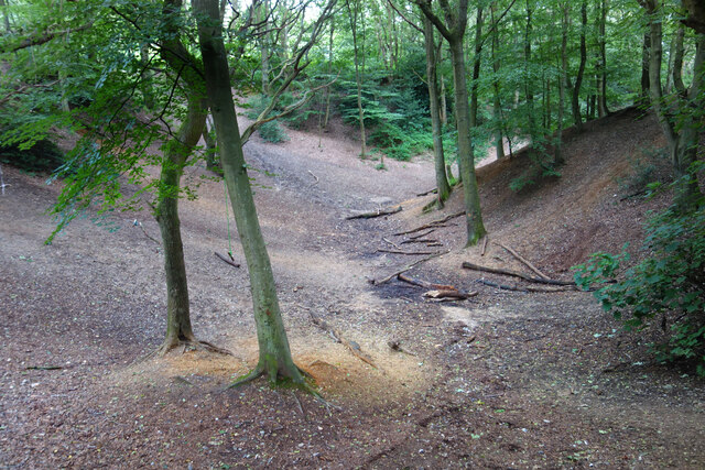
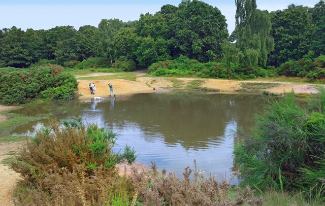
Lion Wood Nature Reserve, located in Norfolk, is a serene and picturesque woodland area that offers visitors the chance to experience the tranquility and natural beauty of a traditional English forest. Spanning over 20 hectares, this nature reserve is known for its diverse range of flora and fauna, making it a haven for nature lovers and wildlife enthusiasts alike.

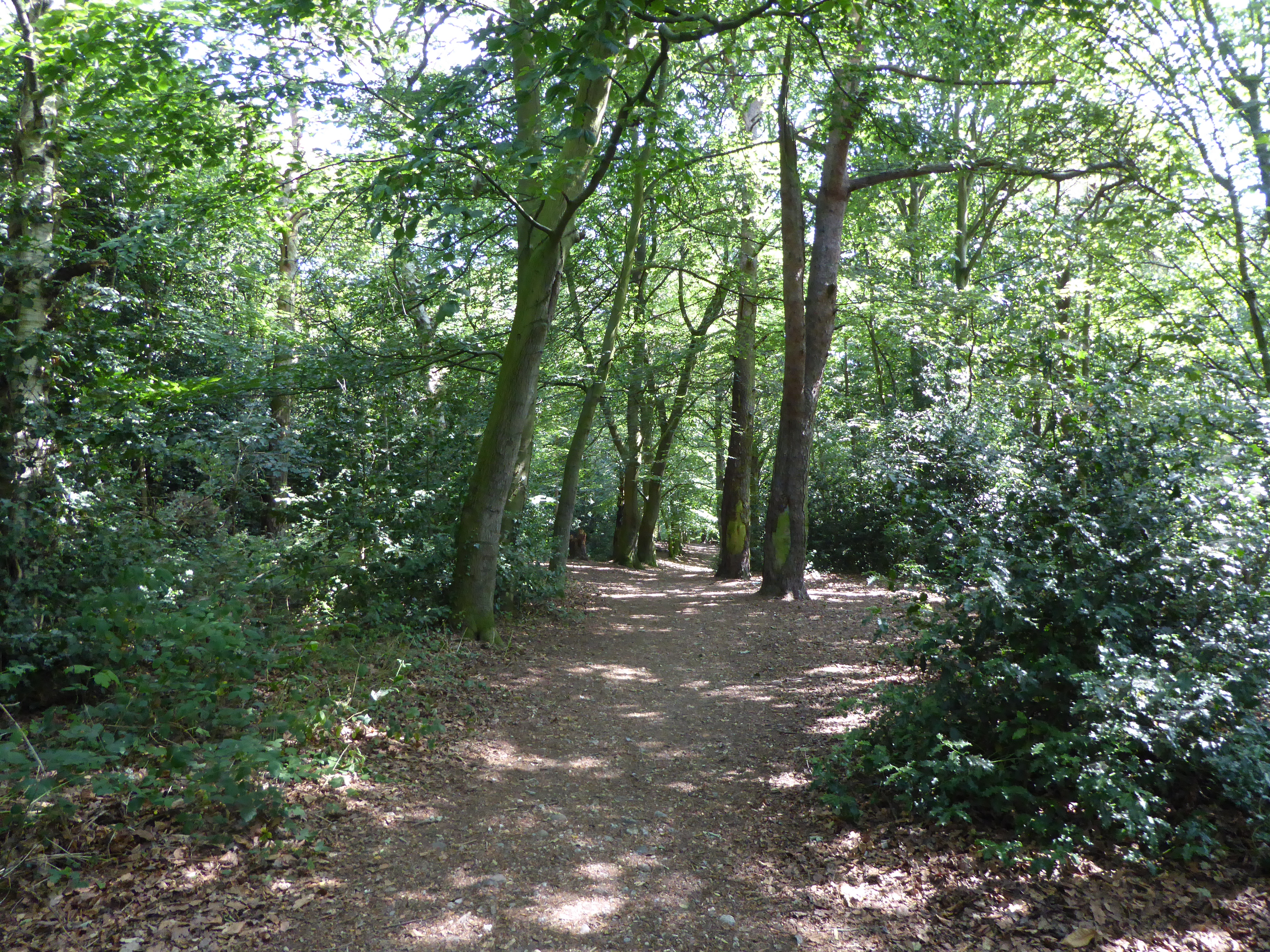
The wood is primarily made up of broadleaf trees, including oak, beech, and ash, which create a dense canopy that provides shade and shelter for a variety of wildlife species. Visitors can explore the reserve through a network of well-maintained trails that wind their way through the forest, offering opportunities for gentle walks and hikes.

One of the main attractions of Lion Wood is its abundance of wildlife. The reserve is home to a wide array of bird species, including woodpeckers, owls, and various songbirds. Additionally, visitors may encounter small mammals like rabbits, squirrels, and hedgehogs, as well as reptiles such as snakes and lizards.

For those interested in plant life, Lion Wood offers a rich tapestry of wildflowers and ferns, particularly in the spring and summer months. Bluebells, primroses, and foxgloves are just a few examples of the vibrant flora that can be found throughout the woodland.

Lion Wood Nature Reserve is a peaceful retreat where visitors can immerse themselves in the beauty of nature and enjoy the sights and sounds of the Norfolk countryside. Whether it's birdwatching, photography, or simply taking a leisurely stroll, this wood offers a truly rewarding experience for all who visit.

If you have any feedback on the listing, please let us know in the comments section below.

Lion Wood Nature Reserve Images

Images are sourced within 2km of 52.631243/1.3209937 or Grid Reference TG2408. Thanks to Geograph Open Source API. All images are credited.

Hills and Hollows, Mousehold Heath A wooded area on the edge of Mousehold Heath which looks like it might have been quarries or claypits at one time.
Hills and Hollows, Mousehold Heath
A wooded area on the edge of Mousehold Heath which looks like it might have been quarries or claypits at one time.
Woodland, Mousehold Heath A surviving fragment of open space now surrounded by suburban Norwich.
"In Tudor times, Mousehold Heath stretched as far north as South Walsham and was 22 miles round. The surviving remnant of the heath was given to Norwich City Council (then known as the local corporation) to look after on behalf of the citizens of Norwich in 1880." quoted from <span class="nowrap"><a title="https://www.norwich.gov.uk/info/20006/sports_parks_and_leisure/1534/about_mousehold_heath" rel="nofollow ugc noopener" href="https://www.norwich.gov.uk/info/20006/sports_parks_and_leisure/1534/about_mousehold_heath">Link</a><img style="margin-left:2px;" alt="External link" title="External link - shift click to open in new window" src="https://s1.geograph.org.uk/img/external.png" width="10" height="10"/></span>
Woodland, Mousehold Heath
A surviving fragment of open space now surrounded by suburban Norwich. "In Tudor times, Mousehold Heath stretched as far north as South Walsham and was 22 miles round. The surviving remnant of the heath was given to Norwich City Council (then known as the local corporation) to look after on behalf of the citizens of Norwich in 1880." quoted from LinkExternal link
The Vinegar Pond, Mousehold Heath The pond gets its name from the occasional red algae bloom turning the water a vinegar like colour.  A long article about the pond and the heath is on <span class="nowrap"><a title="https://www.invisibleworks.co.uk/norwich-the-vinegar-pond/" rel="nofollow ugc noopener" href="https://www.invisibleworks.co.uk/norwich-the-vinegar-pond/">Link</a><img style="margin-left:2px;" alt="External link" title="External link - shift click to open in new window" src="https://s1.geograph.org.uk/img/external.png" width="10" height="10"/></span>
The Vinegar Pond, Mousehold Heath
The pond gets its name from the occasional red algae bloom turning the water a vinegar like colour. A long article about the pond and the heath is on LinkExternal link
Track on Mousehold Heath Mousehold Heath is an 88 hectare remnant of formerly extensive heathland which was given to Norwich City Council in 1880.
It is now surrounded by suburban development.
<span class="nowrap"><a title="https://www.norwich.gov.uk/info/20006/sports_parks_and_leisure/1534/about_mousehold_heath" rel="nofollow ugc noopener" href="https://www.norwich.gov.uk/info/20006/sports_parks_and_leisure/1534/about_mousehold_heath">Link</a><img style="margin-left:2px;" alt="External link" title="External link - shift click to open in new window" src="https://s1.geograph.org.uk/img/external.png" width="10" height="10"/></span>
Track on Mousehold Heath
Mousehold Heath is an 88 hectare remnant of formerly extensive heathland which was given to Norwich City Council in 1880. It is now surrounded by suburban development. LinkExternal link
Gurney Road through Mousehold Heath
Works at Sprowston Retail Park
Gertrude Road, Norwich
Bench in a clearing on Mousehold Heath The heath offers some wild land in easy walking distance from the city centre of Norwich.
Bench in a clearing on Mousehold Heath
The heath offers some wild land in easy walking distance from the city centre of Norwich.
Zaks Diner An American diner in a slightly unexpected place on the edge of Mousehold Heath.
Zaks Diner
An American diner in a slightly unexpected place on the edge of Mousehold Heath.
Woodland path on Mousehold Heath The path is about to descent a gradient which is much steeper than I expected to find in Norfolk.
Woodland path on Mousehold Heath
The path is about to descent a gradient which is much steeper than I expected to find in Norfolk.
Fat Cat Brewery Tap
Fat Cat Brewery Tap
Sprowston Road, Norwich A residential road on the northern side of Norwich. It is quite busy as it is a through road.
Sprowston Road, Norwich
A residential road on the northern side of Norwich. It is quite busy as it is a through road.
Paths diverge, Mousehold Heath Mousehold Heath is the last remnant of a huge area of heathland that, in Tudor times, stretched as far as South Walsham and was 22 miles round. It was given to the city of Norwich in 1880 and is now managed by the city council as a nature reserve. The ill-fated rebel army of Robert Kett camped here in 1549 prior to its attack on Norwich. For more information see <span class="nowrap"><a title="www.norwich.gov.uk/webapps/atoz/service_page.asp?id=1228" rel="nofollow ugc noopener" href="http://www.norwich.gov.uk/webapps/atoz/service_page.asp?id=1228">Link</a><img style="margin-left:2px;" alt="External link" title="External link - shift click to open in new window" src="https://s1.geograph.org.uk/img/external.png" width="10" height="10"/></span> or <span class="nowrap"><a title="http://www.bbc.co.uk/legacies/myths_legends/england/norfolk/" rel="nofollow ugc noopener" href="http://www.bbc.co.uk/legacies/myths_legends/england/norfolk/">Link</a><img style="margin-left:2px;" alt="External link" title="External link - shift click to open in new window" src="https://s1.geograph.org.uk/img/external.png" width="10" height="10"/></span>
Paths diverge, Mousehold Heath
Mousehold Heath is the last remnant of a huge area of heathland that, in Tudor times, stretched as far as South Walsham and was 22 miles round. It was given to the city of Norwich in 1880 and is now managed by the city council as a nature reserve. The ill-fated rebel army of Robert Kett camped here in 1549 prior to its attack on Norwich. For more information see LinkExternal link or LinkExternal link
Tower blocks, Heartsease, Norwich
Road junction, Thorpe St Andrew / Sprowston Double mini roundabouts at junction of Plumstead Road East / Thunder Lane / Woodside Road, by The Woodside pub.
Road junction, Thorpe St Andrew / Sprowston
Double mini roundabouts at junction of Plumstead Road East / Thunder Lane / Woodside Road, by The Woodside pub.
Woodside Road, Norwich Norfolk Children's Services Professional Development Centre (sic) - just where you want to be on a cold, sleety Monday morning
Woodside Road, Norwich
Norfolk Children's Services Professional Development Centre (sic) - just where you want to be on a cold, sleety Monday morning
The Cidershed public house The home of the Fat Cat brewery
The Cidershed public house
The home of the Fat Cat brewery
Lazar House, Norwich The Lazar House was a Leper Hospital in the middle ages. It was outside the city wall, on the north side of the built up area of the time. In recent years it was a branch library, but was closed down due to cutbacks, and is now a community building.
Lazar House, Norwich
The Lazar House was a Leper Hospital in the middle ages. It was outside the city wall, on the north side of the built up area of the time. In recent years it was a branch library, but was closed down due to cutbacks, and is now a community building.
Show me another place!

Lion Wood Nature Reserve is located at Grid Ref: TG2408 (Lat: 52.631243, Lng: 1.3209937)

Administrative County: Norfolk

District: Norwich

Police Authority: Norfolk

What 3 Words

///float.lime.hips. Near Thorpe Hamlet, Norfolk

Related Wikis

Thorpe Hamlet

Thorpe Hamlet is a suburb of Norwich, to the east of the city centre, in the Norwich District, in the English county of Norfolk. It was constituted a separate...

Lion Wood

Lion Wood is a 8.9-hectare (22-acre) Local Nature Reserve in Norwich in Norfolk. It is owned and managed by Norwich City Council.Around a third of this...

Rosary Cemetery, Norwich

Rosary Cemetery was the first non-denominational burial ground in the United Kingdom. Its entrance lies on Rosary Road in Norwich, Norfolk. == History... ==

HM Prison Norwich

HM Prison Norwich is a Category B/C multi-functional prison for adult and juvenile males, located on Mousehold Heath in Norwich, Norfolk, England. The...

Nearby Amenities

Located within 500m of 52.631243,1.3209937
Traffic Calming: hump
Lat/Long: 52.632327/1.327091
Traffic Calming: hump
Lat/Long: 52.631945/1.3263509
Traffic Calming: hump
Lat/Long: 52.6320369/1.3256167
Post Box
Collection Times: Mo-Fr 17:45; Sa 11:00
Operator: Royal Mail
Post Box Type: pillar
Ref: NR1 129
Lat/Long: 52.6271332/1.323072
Post Box
Collection Times: Mo-Fr 16:00; Sa 12:45
Operator: Royal Mail
Post Box Type: pillar
Ref: NR1 138
Royal Cypher: EIIR
Royal Cypher Wikidata: Q33102113
Lat/Long: 52.6336011/1.3161895
Post Box
Collection Times: Mo-Fr 17:30; Sa 11:00
Operator: Royal Mail
Postal Code: NR1
Ref: NR1 141
Lat/Long: 52.6333848/1.3239491
Recycling
William IV PH, Quebec Road
Recycling Glass Bottles: yes
Url: http://www.norwich.gov.uk/intranet_docs/A-Z/Recycling/Recycling_Centres.pdf
Lat/Long: 52.630342/1.315071
Bus Stop
Community Centre, opp
Naptan AtcoCode: 2900N12217
Naptan Bearing: E
Naptan BusStopType: CUS
Naptan CommonName: Community Centre
Naptan Indicator: opp
Naptan Landmark: Community Centre
Naptan Locality: Norwich
Naptan NaptanCode: nfodjdam
Naptan PlusbusZoneRef: NRCH
Naptan Street: Pilling Park Road
Naptan Verified: no
Public Transport: platform
Source: naptan_import
Lat/Long: 52.6320785/1.3261339
Vincent Road, opp
Naptan AtcoCode: 2900N12556
Naptan Bearing: SW
Naptan BusStopType: CUS
Naptan CommonName: Vincent Road
Naptan Indicator: opp
Naptan Landmark: Vincent Road
Naptan Locality: Norwich
Naptan NaptanCode: nfodmdgw
Naptan PlusbusZoneRef: NRCH
Naptan Street: Plumstead Road
Naptan Verified: no
Source: naptan_import
Lat/Long: 52.633809/1.3173514
Hilary Avenue, adj
Naptan AtcoCode: 2900N12557
Naptan Bearing: NE
Naptan BusStopType: CUS
Naptan CommonName: Hilary Avenue
Naptan Indicator: adj
Naptan Landmark: Hilary Avenue
Naptan Locality: Norwich
Naptan NaptanCode: nfodmdja
Naptan PlusbusZoneRef: NRCH
Naptan ShortCommonName: Plumstead Road
Naptan Street: Plumstead Road
Naptan Verified: no
Source: naptan_import
Lat/Long: 52.6351983/1.3216241
Hilary Avenue, opp
Naptan AtcoCode: 2900N12558
Naptan Bearing: SW
Naptan BusStopType: CUS
Naptan CommonName: Hilary Avenue
Naptan Indicator: opp
Naptan Landmark: Hilary Avenue
Naptan Locality: Norwich
Naptan NaptanCode: nfodmdjd
Naptan PlusbusZoneRef: NRCH
Naptan Street: Plumstead Road
Naptan Verified: no
Source: naptan_import
Lat/Long: 52.635288/1.3223418
Bus Stop
Pilling Park Road, adj
Naptan AtcoCode: 2900N12628
Naptan Bearing: W
Naptan CommonName: Pilling Park Road
Naptan Indicator: adj
Naptan Landmark: Lion Wood Road
Naptan Locality: Norwich
Naptan NaptanCode: nfodmgtm
Naptan PlusbusZoneRef: NRCH
Naptan ShortCommonName: Pilling Park Road
Naptan Street: Pilling Park Road
Naptan Verified: no
Public Transport: platform
Source: naptan_import
Lat/Long: 52.6319623/1.3261103
Bus Stop
Pilling Park Road, opp
Naptan AtcoCode: 2900N12629
Naptan Bearing: W
Naptan BusStopType: CUS
Naptan CommonName: Pilling Park Road
Naptan Indicator: opp
Naptan Landmark: Lion Wood Road
Naptan Locality: Norwich
Naptan NaptanCode: nfodmgtp
Naptan PlusbusZoneRef: NRCH
Naptan ShortCommonName: Pilling Park Road
Naptan Street: Pilling Park Road
Naptan Verified: no
Public Transport: platform
Source: naptan_import
Lat/Long: 52.6322873/1.322543
Bus Stop
Wolfe Road
Bus: yes
Naptan AtcoCode: 2900N12630
Naptan Bearing: NE
Naptan BusStopType: CUS
Naptan CommonName: Wolfe Road
Naptan Indicator: opp
Naptan Landmark: Thorpe Middle School
Naptan Locality: Norwich
Naptan NaptanCode: nfodmgtw
Naptan PlusbusZoneRef: NRCH
Naptan ShortCommonName: Wolfe Road
Naptan Street: Wolfe Road
Public Transport: platform
Shelter: no
Source: naptan_import;survey
Lat/Long: 52.6329482/1.3187958
Bus Stop
Wolfe Road
Bus: yes
Naptan AtcoCode: 2900N12631
Naptan Bearing: SW
Naptan BusStopType: CUS
Naptan CommonName: Wolfe Road
Naptan Indicator: adj
Naptan Landmark: Wolf Road Middle School
Naptan Locality: Norwich
Naptan NaptanCode: nfodmgwa
Naptan PlusbusZoneRef: NRCH
Naptan ShortCommonName: Wolfe Road
Naptan Street: Wolfe Road
Public Transport: platform
Shelter: no
Source: naptan_import;survey
Lat/Long: 52.6327985/1.3184748
Bus Stop
Lion Wood Road, adj
Naptan AtcoCode: 2900N12651
Naptan Bearing: E
Naptan CommonName: Lion Wood Road
Naptan Indicator: adj
Naptan Landmark: Lion Wood Road
Naptan Locality: Norwich
Naptan NaptanCode: nfodmjgd
Naptan PlusbusZoneRef: NRCH
Naptan Street: Pilling Park Road
Naptan Verified: no
Public Transport: platform
Source: naptan_import
Lat/Long: 52.6323014/1.3239631
Stanley Avenue, adj
Naptan AtcoCode: 2900N12652
Naptan Bearing: NE
Naptan BusStopType: CUS
Naptan CommonName: Stanley Avenue
Naptan Indicator: adj
Naptan Landmark: Holmwood Rise
Naptan Locality: Norwich
Naptan NaptanCode: nfodmjgj
Naptan PlusbusZoneRef: NRCH
Naptan Street: Harvey Lane
Naptan Verified: no
Source: naptan_import
Lat/Long: 52.6289894/1.3272445
Stanley Avenue, opp
Naptan AtcoCode: 2900N12653
Naptan Bearing: SW
Naptan BusStopType: CUS
Naptan CommonName: Stanley Avenue
Naptan Indicator: opp
Naptan Landmark: Stanley Avenue
Naptan Locality: Norwich
Naptan NaptanCode: nfodmjgm
Naptan PlusbusZoneRef: NRCH
Naptan Street: Harvey Lane
Naptan Verified: no
Source: naptan_import
Lat/Long: 52.6287601/1.3270116
Bus Stop
Waterworks
Bus: yes
Naptan AtcoCode: 2900N12771
Naptan Bearing: SW
Naptan CommonName: Waterworks
Naptan Indicator: adj
Naptan Landmark: Waterworks
Naptan Latitude: 52.6313938
Naptan Locality: Thorpe Hamlet
Naptan Longitude: 1.3152765
Naptan NaptanCode: nfogmwap
Naptan PlusbusZoneRef: NRCH
Naptan Street: Quebec Road
Public Transport: platform
Shelter: no
Source: naptan_import;survey
Lat/Long: 52.6312167/1.3152046
Bus Stop
Waterworks
Bus: yes
Naptan AtcoCode: 2900N12772
Naptan Bearing: NE
Naptan CommonName: Waterworks
Naptan Indicator: opp
Naptan Landmark: Waterworks
Naptan Locality: Thorpe Hamlet
Naptan NaptanCode: nfogmwat
Naptan PlusbusZoneRef: NRCH
Naptan Street: Quebec Road
Public Transport: platform
Shelter: no
Source: naptan_import;survey
Lat/Long: 52.6313265/1.3151289
Check Date: 2023-01-01
Traffic Calming: hump
Lat/Long: 52.6299412/1.3158544
Give Way
Lat/Long: 52.6307002/1.3145898
Turning Circle
Lat/Long: 52.6284031/1.3184511
Turning Circle
Lat/Long: 52.631954/1.3205059
Give Way
Lat/Long: 52.6324387/1.3202435
Turning Circle
Lat/Long: 52.634109/1.321031
Man Made: service_area_interface
Operator: BT
Lat/Long: 52.6340006/1.3213055
Turning Circle
Lat/Long: 52.63266/1.325765
Turning Circle
Lat/Long: 52.633714/1.325835
Traffic Calming: hump
Lat/Long: 52.633118/1.32706
Vincent Road, adj
Naptan AtcoCode: 2900N12555
Naptan Bearing: NE
Naptan BusStopType: CUS
Naptan CommonName: Vincent Road
Naptan Indicator: adj
Naptan Landmark: Vincent Road
Naptan Locality: Norwich
Naptan NaptanCode: nfodmdgt
Naptan PlusbusZoneRef: NRCH
Naptan Street: Plumstead Road
Naptan Verified: no
Source: naptan_import
Lat/Long: 52.6339403/1.3174796
Crossing
Crossing: uncontrolled
Lat/Long: 52.6342956/1.3181345
Parking
Capacity: 21
Lat/Long: 52.631703/1.3264667
Shelter
Lat/Long: 52.6303105/1.3279638
Bench
Backrest: yes
Lat/Long: 52.6306368/1.3279928
Bench
Backrest: yes
Lat/Long: 52.6308549/1.3280604
Barrier: bollard
Lat/Long: 52.6311362/1.3150031
Barrier: bollard
Lat/Long: 52.6314794/1.3136976
Check Date: 2023-01-01
Traffic Calming: hump
Lat/Long: 52.629532/1.3164071
Telegraph Lane East
Operator: UK Power Networks Ltd.
Power: substation
Ref: G 2449 0876 A
Lat/Long: 52.6301843/1.3158045
Give Way
Lat/Long: 52.6324383/1.3155029
Entrance: main
Wheelchair: yes
Lat/Long: 52.6353773/1.3218916
Crossing
Crossing: traffic_signals
Crossing Ref: puffin
Tactile Paving: yes
Lat/Long: 52.6347263/1.3203568
Crossing
Crossing: unmarked
Lat/Long: 52.6351278/1.3237201
Bench
Backrest: no
Seats: 3
Lat/Long: 52.6315372/1.327865
Entrance: yes
Lat/Long: 52.631319/1.313608
Entrance: main
Lat/Long: 52.6312956/1.3136941
Historic: memorial
Memorial: war_memorial
Lat/Long: 52.631124/1.313687
Give Way
Lat/Long: 52.6333236/1.3239965
Give Way
Lat/Long: 52.63333/1.3240857
Barrier: bollard
Lat/Long: 52.6309596/1.3138667
Give Way
Lat/Long: 52.6287753/1.3269424
Give Way
Lat/Long: 52.6286731/1.3267855
Bicycle Rental
Bicycle Rental: dropoff_point
Network: Beryl Bikes
Lat/Long: 52.6352493/1.3218923
Bench
Backrest: yes
Material: wood
Lat/Long: 52.6271371/1.3202352
Bicycle Rental
Britannia Road
Capacity: 6
Email: support@beryl.cc
Fee: yes
Name Signed: no
Network: Beryl - Norwich
Official Name: Britannia Road
Operator: Beryl
Operator Wikidata: Q106575369
Payment App: yes
Payment App Android: cc.beryl.basis
Payment App Ios: 1386768364
Payment Cash: no
Payment Credit Cards: no
Payment Cryptocurrencies: no
Payment Debit Cards: no
Payment Electronic Purses: no
Phone: +44 20 3003 5044
Ref Gbfs: beryl_norwich:2047
Rental: city_bike;ebike;escooter
Website: https://beryl.cc/scheme/norwich
Lat/Long: 52.6334534/1.316327
Bicycle Rental
Plumstead Road Library
Bicycle Rental: dropoff_point
Capacity: 8
Email: support@beryl.cc
Fee: yes
Name Signed: no
Network: Beryl - Norwich
Official Name: Plumstead Road Library
Operator: Beryl
Operator Wikidata: Q106575369
Payment App: yes
Payment App Android: cc.beryl.basis
Payment App Ios: 1386768364
Payment Cash: no
Payment Credit Cards: no
Payment Cryptocurrencies: no
Payment Debit Cards: no
Payment Electronic Purses: no
Phone: +44 20 3003 5044
Ref Gbfs: beryl_norwich:1959
Rental: city_bike;ebike;escooter
Website: https://beryl.cc/scheme/norwich
Lat/Long: 52.6352768/1.322001
Waste Basket
Lat/Long: 52.6305209/1.3269867
Waste Basket
Colour: green
Material: plastic
Lat/Long: 52.6324783/1.3145198
Waste Basket
Lat/Long: 52.6291902/1.3169873
Waste Basket
Lat/Long: 52.6305641/1.3283067
Waste Basket
Lat/Long: 52.6314834/1.3279149
Waste Basket
Colour: green
Material: plastic
Lat/Long: 52.6352575/1.3223045
Waste Basket
Lat/Long: 52.6318747/1.3204614
Waste Basket
Lat/Long: 52.6289737/1.3213032
Waste Basket
Colour: green
Material: plastic
Lat/Long: 52.6297878/1.3159717
Waste Basket
Colour: green
Material: plastic
Lat/Long: 52.6329442/1.3194264
Waste Basket
Colour: green
Material: plastic
Lat/Long: 52.6328657/1.3187503
Waste Basket
Lat/Long: 52.6315323/1.3261666
Waste Basket
Lat/Long: 52.6315266/1.3272503
Waste Basket
Colour: green
Material: plastic
Lat/Long: 52.6336273/1.3199176
Give Way
Lat/Long: 52.6324411/1.315417
Bicycle Rental
Pilling Park
Capacity: 4
Email: support@beryl.cc
Fee: yes
Name Signed: no
Network: Beryl - Norwich
Official Name: Pilling Park
Operator: Beryl
Operator Wikidata: Q106575369
Payment App: yes
Payment App Android: cc.beryl.basis
Payment App Ios: 1386768364
Payment Cash: no
Payment Credit Cards: no
Payment Cryptocurrencies: no
Payment Debit Cards: no
Payment Electronic Purses: no
Phone: +44 20 3003 5044
Ref Gbfs: beryl_norwich:1899
Rental: city_bike;ebike;escooter
Website: https://beryl.cc/scheme/norwich
Lat/Long: 52.6318588/1.32627
Grit Bin
Colour: yellow
Lat/Long: 52.6287801/1.3268325
Barrier: cycle_barrier
Bicycle: no
Lat/Long: 52.6280241/1.3260211
Give Way
Lat/Long: 52.6330115/1.3200559
Give Way
Lat/Long: 52.6330302/1.3201532
Waste Basket
Waste: trash
Lat/Long: 52.6279311/1.3162327
Waste Basket
Waste: trash
Lat/Long: 52.6280363/1.3165683
Entrance: yes
Lat/Long: 52.6284417/1.3260178
Communication Mobile Phone: yes
Layer: 1
Man Made: mast
Material: metal
Operator: Three UK;EE;O2-UK;Vodafone UK
Tower Construction: guyed_tube
Tower Type: communication
Lat/Long: 52.6309514/1.3165622
Give Way
Lat/Long: 52.6318737/1.3153821
The data included in this document is from www.openstreetmap.org. The data is made available under ODbL.

Have you been to Lion Wood Nature Reserve?

Leave your review of Lion Wood Nature Reserve below (or comments, questions and feedback).