Mousehold Heath

Wood, Forest in Norfolk Norwich

England

Mousehold Heath

Alderford Terrace, Magdalen Road, Norwich Some early 19th century cottages along Magdalen Road, Norwich. An OS Map from the 1880s tells me this row is called Alderford Terrace but I am not sure if the name is still in use today.
Alderford Terrace, Magdalen Road, Norwich Credit: Adam Smith

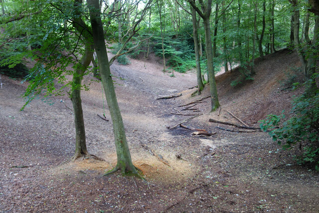
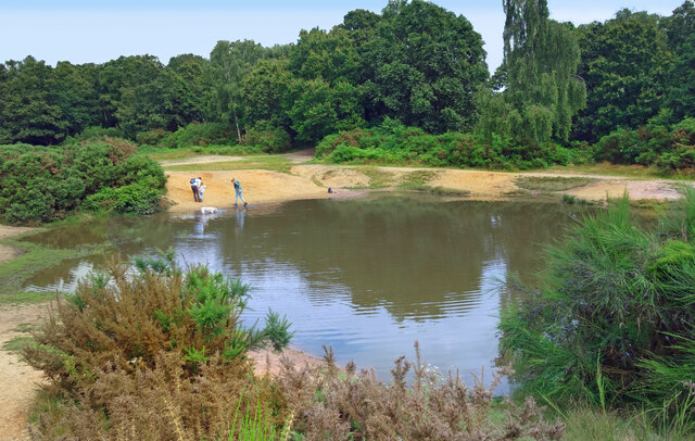
Mousehold Heath is a large woodland area located in Norwich, Norfolk, England. Covering an expansive area of approximately 184 acres, it is a popular destination for both locals and tourists seeking tranquility and natural beauty. The heath is situated on a plateau, providing stunning views of the surrounding landscape.

The woodland is predominantly composed of a mix of deciduous and coniferous trees, including oak, birch, and pine. These trees provide a diverse habitat for a variety of wildlife, making Mousehold Heath a haven for nature enthusiasts. Visitors can spot a range of bird species, such as woodpeckers, buzzards, and tawny owls, along with small mammals like squirrels and rabbits.

The heath has a rich historical significance, with its roots dating back to the medieval era. In the past, it was utilized as a common grazing area for livestock and as a source of timber for the local community. Today, remnants of its history can still be seen, including old quarries and pathways.

Mousehold Heath offers a range of recreational activities for visitors. There are numerous walking trails that wind through the woodland, allowing visitors to explore its natural wonders at their own pace. Additionally, the heath is a popular spot for picnicking, jogging, and dog walking. Its open spaces and peaceful environment make it an ideal place for relaxation and escape from the hustle and bustle of city life.

In conclusion, Mousehold Heath is a picturesque woodland area in Norfolk, offering a blend of natural beauty, historical significance, and recreational opportunities. Its diverse flora and fauna, coupled with its stunning views and serene atmosphere, make it a must-visit destination for nature lovers and those seeking a peaceful retreat.

If you have any feedback on the listing, please let us know in the comments section below.

Mousehold Heath Images

Images are sourced within 2km of 52.642677/1.3173658 or Grid Reference TG2410. Thanks to Geograph Open Source API. All images are credited.

Alderford Terrace, Magdalen Road, Norwich Some early 19th century cottages along Magdalen Road, Norwich. An OS Map from the 1880s tells me this row is called Alderford Terrace but I am not sure if the name is still in use today.
Alderford Terrace, Magdalen Road, Norwich
Some early 19th century cottages along Magdalen Road, Norwich. An OS Map from the 1880s tells me this row is called Alderford Terrace but I am not sure if the name is still in use today.
The Dyers Arms, Magdalen Road, Norwich Sadly no longer a PH having closed around 2019. The former Dyers Arms has become a "health and wellbeing clinic". In 1986 the Norwich Society described it as an "unremarkable local".

<span class="nowrap"><a title="https://www.norfolkpubs.co.uk/norwich/gnorwich/ncgld.htm" rel="nofollow ugc noopener" href="https://www.norfolkpubs.co.uk/norwich/gnorwich/ncgld.htm">Link</a><img style="margin-left:2px;" alt="External link" title="External link - shift click to open in new window" src="https://s1.geograph.org.uk/img/external.png" width="10" height="10"/></span>
The Dyers Arms, Magdalen Road, Norwich
Sadly no longer a PH having closed around 2019. The former Dyers Arms has become a "health and wellbeing clinic". In 1986 the Norwich Society described it as an "unremarkable local". LinkExternal link
Christ Church, New Catton, Norwich A view across to Christ Church, New Catton in Norwich on a wet December morning. A rather striking church dating from 1842 and, apparently, pre-dating all of the housing which surrounds it. Simon Knott's excellent Norfolk Churches site seems to suggest it has a similarly striking mint green interior which I sadly did not get to see.

<span class="nowrap"><a title="http://www.norfolkchurches.co.uk/newcatton/newcatton.htm" rel="nofollow ugc noopener" href="http://www.norfolkchurches.co.uk/newcatton/newcatton.htm">Link</a><img style="margin-left:2px;" alt="External link" title="External link - shift click to open in new window" src="https://s1.geograph.org.uk/img/external.png" width="10" height="10"/></span>
Christ Church, New Catton, Norwich
A view across to Christ Church, New Catton in Norwich on a wet December morning. A rather striking church dating from 1842 and, apparently, pre-dating all of the housing which surrounds it. Simon Knott's excellent Norfolk Churches site seems to suggest it has a similarly striking mint green interior which I sadly did not get to see. LinkExternal link
Sewell Park, New Catton, Norwich The southern entrance to Sewell Park in New Catton. The handsome triangular drinking trough here can be seen on an OS Map from the late-19th century. A final stopping place before heading into the city centre perhaps.

A similarly handsome bronze plaque can be seen behind it describing how this open space was once used and loved by Philip Edward Sewell and is now dedicated to his memory.
Sewell Park, New Catton, Norwich
The southern entrance to Sewell Park in New Catton. The handsome triangular drinking trough here can be seen on an OS Map from the late-19th century. A final stopping place before heading into the city centre perhaps. A similarly handsome bronze plaque can be seen behind it describing how this open space was once used and loved by Philip Edward Sewell and is now dedicated to his memory.
Sewell Park Academy, Norwich As with many schools in Norfolk, this one has a long history of changing with the educational winds. It was opened in 1929 as Blyth Grammar School, it became a comprehensive school in 1971 and merged with Alderman Jex School to become Blyth-Jex School in 1972. In 2008, it became Sewell Park College and, in 2015, it became Sewell Park Academy. 

Apparently a whalebone, donated by a former student, stands in the grounds.
<a href="https://www.geograph.org.uk/photo/166094">TG2310 : Whale's Jawbone Arch in the grounds of Blyth Jex School</a>
Sewell Park Academy, Norwich
As with many schools in Norfolk, this one has a long history of changing with the educational winds. It was opened in 1929 as Blyth Grammar School, it became a comprehensive school in 1971 and merged with Alderman Jex School to become Blyth-Jex School in 1972. In 2008, it became Sewell Park College and, in 2015, it became Sewell Park Academy. Apparently a whalebone, donated by a former student, stands in the grounds. TG2310 : Whale's Jawbone Arch in the grounds of Blyth Jex School
Tombland, Norwich A view of Tombland on an exceptionally wet December morning. The Cathedral can be seen in the distance. 

The obelisk is a memorial to machinery which stood on this site between 1700 and 1830 which raised and stored water for the higher parts of the city. In 1860, a drinking fountain was erected here to commemorate this by John Henry Gurney.

<span class="nowrap"><a title="https://artuk.org/discover/artworks/gurney-drinking-fountain-and-obelisk-313011" rel="nofollow ugc noopener" href="https://artuk.org/discover/artworks/gurney-drinking-fountain-and-obelisk-313011">Link</a><img style="margin-left:2px;" alt="External link" title="External link - shift click to open in new window" src="https://s1.geograph.org.uk/img/external.png" width="10" height="10"/></span>
Tombland, Norwich
A view of Tombland on an exceptionally wet December morning. The Cathedral can be seen in the distance. The obelisk is a memorial to machinery which stood on this site between 1700 and 1830 which raised and stored water for the higher parts of the city. In 1860, a drinking fountain was erected here to commemorate this by John Henry Gurney. LinkExternal link
Former Quayside School, Norwich A quite unusual example of Victorian architecture - this is the former girls and infants section of Quayside School at the bottom of Piggs Lane, Norwich.
Former Quayside School, Norwich
A quite unusual example of Victorian architecture - this is the former girls and infants section of Quayside School at the bottom of Piggs Lane, Norwich.
View along Quayside, Norwich The view along Quayside, Norwich looking towards Fye Bridge on a very rainy December morning. A double decker bus crosses over the bridge heading into the city centre.
View along Quayside, Norwich
The view along Quayside, Norwich looking towards Fye Bridge on a very rainy December morning. A double decker bus crosses over the bridge heading into the city centre.
Looking up Golden Dog Lane, Norwich The view up Golden Dog Lane, Norwich as seen from Magdalen Street. The building on the right was once the Golden Dog PH but is now a barbershop. At one time the Golden Dog had not only a bar but also a very small brewery on site. 

<span class="nowrap"><a title="https://www.norfolkpubs.co.uk/norwich/gnorwich/ncgld.htm" rel="nofollow ugc noopener" href="https://www.norfolkpubs.co.uk/norwich/gnorwich/ncgld.htm">Link</a><img style="margin-left:2px;" alt="External link" title="External link - shift click to open in new window" src="https://s1.geograph.org.uk/img/external.png" width="10" height="10"/></span>
Looking up Golden Dog Lane, Norwich
The view up Golden Dog Lane, Norwich as seen from Magdalen Street. The building on the right was once the Golden Dog PH but is now a barbershop. At one time the Golden Dog had not only a bar but also a very small brewery on site. LinkExternal link
Former Barclays Bank, Magdalen Street, Norwich A rather Brutalist former Barclays Bank built in the 1960s alongside the Anglia Square shopping centre. It is now derelict but was, for a short while, an international food supermarket. There are plans in the work to demolish it and replace it with a four storey block of flats.
Former Barclays Bank, Magdalen Street, Norwich
A rather Brutalist former Barclays Bank built in the 1960s alongside the Anglia Square shopping centre. It is now derelict but was, for a short while, an international food supermarket. There are plans in the work to demolish it and replace it with a four storey block of flats.
Looking south down Magdalen Street, Norwich Looking back south into the city centre from where Bull Close Road meets Magdalen Street. The rather excellent Bread Source bakery and Malt and Mardle pub can be seen to the right.
Looking south down Magdalen Street, Norwich
Looking back south into the city centre from where Bull Close Road meets Magdalen Street. The rather excellent Bread Source bakery and Malt and Mardle pub can be seen to the right.
Hills and Hollows, Mousehold Heath A wooded area on the edge of Mousehold Heath which looks like it might have been quarries or claypits at one time.
Hills and Hollows, Mousehold Heath
A wooded area on the edge of Mousehold Heath which looks like it might have been quarries or claypits at one time.
Woodland, Mousehold Heath A surviving fragment of open space now surrounded by suburban Norwich.
"In Tudor times, Mousehold Heath stretched as far north as South Walsham and was 22 miles round. The surviving remnant of the heath was given to Norwich City Council (then known as the local corporation) to look after on behalf of the citizens of Norwich in 1880." quoted from <span class="nowrap"><a title="https://www.norwich.gov.uk/info/20006/sports_parks_and_leisure/1534/about_mousehold_heath" rel="nofollow ugc noopener" href="https://www.norwich.gov.uk/info/20006/sports_parks_and_leisure/1534/about_mousehold_heath">Link</a><img style="margin-left:2px;" alt="External link" title="External link - shift click to open in new window" src="https://s1.geograph.org.uk/img/external.png" width="10" height="10"/></span>
Woodland, Mousehold Heath
A surviving fragment of open space now surrounded by suburban Norwich. "In Tudor times, Mousehold Heath stretched as far north as South Walsham and was 22 miles round. The surviving remnant of the heath was given to Norwich City Council (then known as the local corporation) to look after on behalf of the citizens of Norwich in 1880." quoted from LinkExternal link
The Vinegar Pond, Mousehold Heath The pond gets its name from the occasional red algae bloom turning the water a vinegar like colour.  A long article about the pond and the heath is on <span class="nowrap"><a title="https://www.invisibleworks.co.uk/norwich-the-vinegar-pond/" rel="nofollow ugc noopener" href="https://www.invisibleworks.co.uk/norwich-the-vinegar-pond/">Link</a><img style="margin-left:2px;" alt="External link" title="External link - shift click to open in new window" src="https://s1.geograph.org.uk/img/external.png" width="10" height="10"/></span>
The Vinegar Pond, Mousehold Heath
The pond gets its name from the occasional red algae bloom turning the water a vinegar like colour. A long article about the pond and the heath is on LinkExternal link
Track on Mousehold Heath Mousehold Heath is an 88 hectare remnant of formerly extensive heathland which was given to Norwich City Council in 1880.
It is now surrounded by suburban development.
<span class="nowrap"><a title="https://www.norwich.gov.uk/info/20006/sports_parks_and_leisure/1534/about_mousehold_heath" rel="nofollow ugc noopener" href="https://www.norwich.gov.uk/info/20006/sports_parks_and_leisure/1534/about_mousehold_heath">Link</a><img style="margin-left:2px;" alt="External link" title="External link - shift click to open in new window" src="https://s1.geograph.org.uk/img/external.png" width="10" height="10"/></span>
Track on Mousehold Heath
Mousehold Heath is an 88 hectare remnant of formerly extensive heathland which was given to Norwich City Council in 1880. It is now surrounded by suburban development. LinkExternal link
The Rosebery, New Catton Light is rapidly fading on this December afternoon but the fine old Victorian pub looks inviting. It was formerly known as the Lord Rosebery, named after Archibald Primrose who was Liberal Prime Minister between 1894 and 1895.
The Rosebery, New Catton
Light is rapidly fading on this December afternoon but the fine old Victorian pub looks inviting. It was formerly known as the Lord Rosebery, named after Archibald Primrose who was Liberal Prime Minister between 1894 and 1895.
Gurney Road through Mousehold Heath
Works at Sprowston Retail Park
Show me another place!

Mousehold Heath is located at Grid Ref: TG2410 (Lat: 52.642677, Lng: 1.3173658)

Administrative County: Norfolk

District: Norwich

Police Authority: Norfolk

What 3 Words

///chair.belong.fantastic. Near Thorpe Hamlet, Norfolk

Related Wikis

Mousehold Heath

Mousehold Heath is a freely accessible area of heathland and woodland which lies to the north-east of the medieval city boundary of Norwich, in Norfolk...

Britannia Barracks

Britannia Barracks was a military installation in Norwich. == History == The barracks were built in the architectural style of Norman Shaw on Mousehold...

HM Prison Norwich

HM Prison Norwich is a Category B/C multi-functional prison for adult and juvenile males, located on Mousehold Heath in Norwich, Norfolk, England. The...
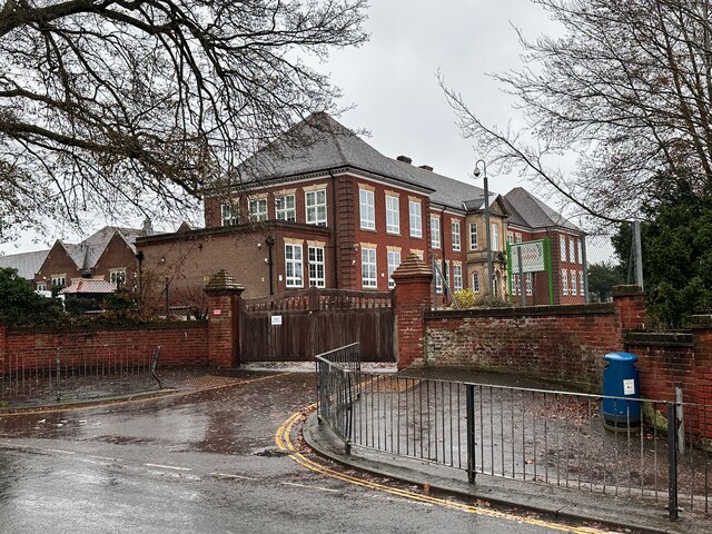
Open Academy

Open Academy (formerly Heartsease High School) is a secondary school with academy status located in the Heartsease area of Norwich, in the English county...

St James' Pit

St James' Pit is a 3.5-hectare (8.6-acre) geological Site of Special Scientific Interest in Norwich in Norfolk. It is a Geological Conservation Review...

Sprowston Community Academy

Sprowston Community Academy is a coeducational secondary school located in Sprowston, Norwich, Norfolk, England. == Description == Ofsted visiting the...

RAF Mousehold Heath

The area of Norwich between the Salhouse and Plumstead roads (outside of the outer ring road) was originally the Cavalry Training Ground and then became...

Heartsease Estate, Norwich

The Heartsease is a housing estate located in Norwich, Norfolk and takes its name from the heartsease, a common European wild flower. == Location == The...

Nearby Amenities

Located within 500m of 52.642677,1.3173658
Traffic Signals
Lat/Long: 52.6449785/1.3230302
Traffic Signals
Lat/Long: 52.645907/1.3212465
Post Box
Collection Times: Mo-Fr 09:00; Sa 07:00
Operator: Royal Mail
Post Box Type: pillar
Ref: NR1 137D
Royal Cypher: EIIR
Royal Cypher Wikidata: Q33102113
Lat/Long: 52.6399078/1.3223655
Bus Stop
Shops, adj
Naptan AtcoCode: 2900N12164
Naptan Bearing: W
Naptan CommonName: Shops
Naptan Indicator: adj
Naptan Landmark: Shops
Naptan Locality: Norwich
Naptan NaptanCode: nfodjajg
Naptan PlusbusZoneRef: NRCH
Naptan Street: Borrowdale Drive
Naptan Verified: no
Public Transport: platform
Source: naptan_import
Lat/Long: 52.6398654/1.322685
Bus Stop
Gilman Road, opp
Naptan AtcoCode: 2900N12166
Naptan Bearing: SW
Naptan CommonName: Gilman Road
Naptan Indicator: opp
Naptan Landmark: Gilman Road
Naptan Locality: Norwich
Naptan NaptanCode: nfogpmdg
Naptan PlusbusZoneRef: NRCH
Naptan Street: Mousehold Avenue
Naptan Verified: no
Shelter: no
Source: naptan_import
Lat/Long: 52.6410228/1.3121907
Bus Stop
Royal Norfolk Cottages, opp
Bench: no
Naptan AtcoCode: 2900N12214
Naptan Bearing: NW
Naptan BusStopType: CUS
Naptan CommonName: Royal Norfolk Cottages
Naptan Indicator: opp
Naptan Landmark: Royal Norfolk Cottages
Naptan Locality: Norwich
Naptan NaptanCode: nfodjdad
Naptan PlusbusZoneRef: NRCH
Naptan Street: Mousehold Lane
Naptan Verified: no
Public Transport: platform
Shelter: no
Source: naptan_import
Tactile Paving: no
Lat/Long: 52.6462744/1.3202475
Bus Stop
Shops, opp
Naptan AtcoCode: 2900N12263
Naptan Bearing: E
Naptan CommonName: Shops
Naptan Indicator: opp
Naptan Locality: Norwich
Naptan NaptanCode: nfodjgap
Naptan PlusbusZoneRef: NRCH
Naptan Street: Borrowdale Drive
Naptan Verified: no
Public Transport: platform
Source: naptan_import
Lat/Long: 52.6399287/1.322675
Bus Stop
Royal Norfolk Cottages, adj
Bench: no
Naptan AtcoCode: 2900N1238
Naptan Bearing: SE
Naptan BusStopType: CUS
Naptan CommonName: Royal Norfolk Cottages
Naptan Indicator: adj
Naptan Landmark: Royal Norfolk Cottages
Naptan Locality: Norwich
Naptan NaptanCode: nfodjpjw
Naptan PlusbusZoneRef: NRCH
Naptan Street: Mousehold Lane
Naptan Verified: no
Public Transport: platform
Shelter: no
Source: naptan_import
Tactile Paving: no
Lat/Long: 52.6463796/1.3203442
Bus Stop
Riseway Close, opp
Naptan AtcoCode: 2900N12657
Naptan Bearing: NW
Naptan BusStopType: CUS
Naptan CommonName: Riseway Close
Naptan Indicator: opp
Naptan Locality: Norwich
Naptan NaptanCode: nfodmjma
Naptan PlusbusZoneRef: NRCH
Naptan Street: Borrowdale Drive
Naptan Verified: no
Public Transport: platform
Source: naptan_import
Lat/Long: 52.6388272/1.3199343
Bus Stop
Riseway Close, adj
Naptan AtcoCode: 2900N12658
Naptan Bearing: SE
Naptan BusStopType: CUS
Naptan CommonName: Riseway Close
Naptan Indicator: adj
Naptan Landmark: Riseway Close
Naptan Locality: Norwich
Naptan NaptanCode: nfodmjmd
Naptan PlusbusZoneRef: NRCH
Naptan Street: Borrowdale Drive
Naptan Verified: no
Public Transport: platform
Source: naptan_import
Lat/Long: 52.6386847/1.3202044
Barrier: swing_gate
Lat/Long: 52.6391561/1.3146835
Check Date: 2021-05-23
Traffic Calming: cushion
Lat/Long: 52.6409465/1.3131254
Barrier: bollard
Lat/Long: 52.6400166/1.3147292
Traffic Calming: choker
Lat/Long: 52.641978/1.310083
Barrier: bollard
Bicycle: yes
Foot: yes
Lat/Long: 52.6412139/1.3125675
Crossing
Crossing: uncontrolled
Tactile Paving: yes
Traffic Calming: table
Lat/Long: 52.6415736/1.314955
Bench
Lat/Long: 52.6457392/1.3170119
Turning Circle
Lat/Long: 52.646474/1.320662
Crossing
Crossing: traffic_signals
Crossing Island: yes
Crossing Ref: pelican
Tactile Paving: yes
Lat/Long: 52.6448794/1.3232208
Barrier: kerb
Kerb: flush
Tactile Paving: no
Lat/Long: 52.6449011/1.3229256
Crossing
Crossing: unmarked
Crossing Island: yes
Tactile Paving: no
Lat/Long: 52.6449314/1.322852
Crossing
Crossing: traffic_signals
Crossing Ref: pelican
Tactile Paving: yes
Lat/Long: 52.6449599/1.323415
Barrier: kerb
Kerb: flush
Tactile Paving: no
Lat/Long: 52.64497/1.3228141
Traffic Signals
Lat/Long: 52.6450038/1.3234514
Crossing
Button Operated: no
Check Date Tactile Paving: 2021-05-23
Crossing: traffic_signals
Crossing Island: no
Tactile Paving: no
Traffic Signals Sound: no
Traffic Signals Vibration: no
Lat/Long: 52.6450338/1.3232574
Grit Bin
Ref: 303
Lat/Long: 52.6397626/1.3227418
Telephone
Booth: KX100
Covered: booth
Operator: BT
Lat/Long: 52.6398952/1.3223677
Check Date: 2021-05-23
Traffic Calming: cushion
Lat/Long: 52.6396818/1.3123142
Check Date: 2021-05-23
Traffic Calming: cushion
Lat/Long: 52.6412847/1.3137961
Bench
Lat/Long: 52.645839/1.3175748
Bench
Lat/Long: 52.6462664/1.3141452
Bench
Lat/Long: 52.6463964/1.3157614
Crossing
Crossing: unmarked
Lat/Long: 52.6412188/1.3134824
Crossing
Crossing: unmarked
Lat/Long: 52.641921/1.3162012
Crossing
Crossing: unmarked
Lat/Long: 52.6414546/1.3143323
Waste Basket
Lat/Long: 52.640579/1.3134186
Waste Basket
Lat/Long: 52.6443599/1.3197045
Waste Basket
Lat/Long: 52.6435889/1.3206771
Waste Basket
Lat/Long: 52.6415809/1.314098
Waste Basket
Lat/Long: 52.6413419/1.3142427
Waste Basket
Lat/Long: 52.6462964/1.3182601
Waste Basket
Lat/Long: 52.6415999/1.3154621
Waste Basket
Lat/Long: 52.6421418/1.3231514
Waste Basket
Lat/Long: 52.6389811/1.3205257
Waste Basket
Lat/Long: 52.6424237/1.3218107
Waste Basket
Colour: green
Material: plastic
Lat/Long: 52.6398661/1.3229883
Waste Basket
Lat/Long: 52.6406192/1.3152724
Waste Basket
Lat/Long: 52.64172/1.3140197
Waste Basket
Lat/Long: 52.6406467/1.3236806
Waste Basket
Lat/Long: 52.6430451/1.3229088
Waste Basket
Lat/Long: 52.6416978/1.3158187
Waste Basket
Lat/Long: 52.6391501/1.3208387
Parcel Locker
faille
Brand: Amazon Locker
Brand Wikidata: Q16974764
Lat/Long: 52.6456698/1.3225932
Bench
Backrest: yes
Inscription: In loving memory of Ian Kent who was proud to be a heath defender
Material: wood
Lat/Long: 52.6462776/1.3179949
Traffic Calming: bump
Lat/Long: 52.6419785/1.3162989
The data included in this document is from www.openstreetmap.org. The data is made available under ODbL.

Have you been to Mousehold Heath?

Leave your review of Mousehold Heath below (or comments, questions and feedback).