Ackholt Wood

Wood, Forest in Kent Dover

England

Ackholt Wood

Lane heading away from Woolage Green
Lane heading away from Woolage Green Credit: Robin Webster

Ackholt Wood is a picturesque forest located in the county of Kent, England. Covering an area of approximately 200 acres, it is a haven for nature enthusiasts and provides a tranquil escape from the hustle and bustle of everyday life.

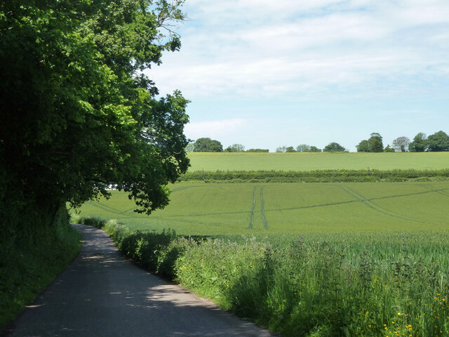
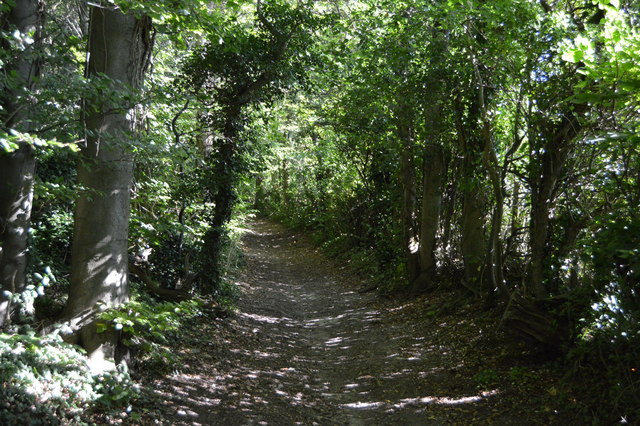
The wood is predominantly made up of broadleaf trees, such as oak, beech, and ash, which create a dense canopy overhead. This natural canopy not only offers shade and shelter for a diverse range of wildlife, but also provides a beautiful backdrop for visitors.

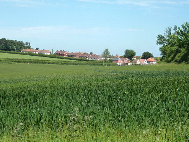
The forest floor is a tapestry of wildflowers, ferns, and mosses, which thrive in the damp and shaded environment. It is also home to a variety of animal species, including deer, rabbits, squirrels, and a wide array of birdlife.

Ackholt Wood is crisscrossed by a network of well-maintained walking trails, allowing visitors to explore the wood at their own pace. These trails lead through different sections of the forest, offering glimpses of ancient trees and hidden glades along the way.

The wood is open to the public year-round, and admission is free. It is a popular destination for families, dog walkers, and nature lovers who come to enjoy the peaceful surroundings and reconnect with nature.

In addition to its natural beauty, Ackholt Wood also has historical significance. The remains of an Iron Age settlement have been discovered within the wood, adding an extra layer of intrigue for those interested in archaeology and history.

Overall, Ackholt Wood is a natural gem in the heart of Kent, offering a serene escape and a chance to immerse oneself in the beauty of the British countryside.

If you have any feedback on the listing, please let us know in the comments section below.

Ackholt Wood Images

Images are sourced within 2km of 51.218204/1.2025353 or Grid Reference TR2351. Thanks to Geograph Open Source API. All images are credited.

Lane heading away from Woolage Green
View towards Woolage Village
Leighgate Bottom
Leighgate Bottom
Byway to Woolage Green
Nethersole Rd
Nethersole Rd
Leighgate Bottom
Leighgate Bottom
Nethersole Rd
Nethersole Rd
North Downs Way A long distance path in southern England. It runs from Farnham to Dover, past Godalming, Guildford, Dorking, Merstham, Otford and Rochester, along the Surrey Hills Area of Outstanding Natural Beauty (AONB) and Kent Downs AONB. East of Boughton Lees, the path splits in two, the northern section running via Canterbury and the southern via Wye. The two sections of the path reunite at Dover. The northern route is 211 km long, and the southern route 201 km, the total length of the North Downs Way being 246 km.
The pathway is mixed in that it varies throughout its length from footpath status to bridleway, byway and road. Some 19% of the Way follows roads, though 75% of those are minor lanes. It is marked by an acorn. See <a href="https://www.geograph.org.uk/photo/1165027">TQ6561 : Crossover in Long Distance pathways</a>.
See <span class="nowrap"><a title="http://www.nationaltrail.co.uk/Northdowns/" rel="nofollow ugc noopener" href="http://www.nationaltrail.co.uk/Northdowns/">Link</a><img style="margin-left:2px;" alt="External link" title="External link - shift click to open in new window" src="https://s1.geograph.org.uk/img/external.png" width="10" height="10"/></span> for more details and an interactive map of the trail.
North Downs Way
A long distance path in southern England. It runs from Farnham to Dover, past Godalming, Guildford, Dorking, Merstham, Otford and Rochester, along the Surrey Hills Area of Outstanding Natural Beauty (AONB) and Kent Downs AONB. East of Boughton Lees, the path splits in two, the northern section running via Canterbury and the southern via Wye. The two sections of the path reunite at Dover. The northern route is 211 km long, and the southern route 201 km, the total length of the North Downs Way being 246 km. The pathway is mixed in that it varies throughout its length from footpath status to bridleway, byway and road. Some 19% of the Way follows roads, though 75% of those are minor lanes. It is marked by an acorn. See TQ6561 : Crossover in Long Distance pathways. See LinkExternal link for more details and an interactive map of the trail.
Farmland, Leightongate Bottom
North Downs Way A long distance path in southern England. It runs from Farnham to Dover, past Godalming, Guildford, Dorking, Merstham, Otford and Rochester, along the Surrey Hills Area of Outstanding Natural Beauty (AONB) and Kent Downs AONB. East of Boughton Lees, the path splits in two, the northern section running via Canterbury and the southern via Wye. The two sections of the path reunite at Dover. The northern route is 211 km long, and the southern route 201 km, the total length of the North Downs Way being 246 km.
The pathway is mixed in that it varies throughout its length from footpath status to bridleway, byway and road. Some 19% of the Way follows roads, though 75% of those are minor lanes. It is marked by an acorn. See <a href="https://www.geograph.org.uk/photo/1165027">TQ6561 : Crossover in Long Distance pathways</a>.
See <span class="nowrap"><a title="http://www.nationaltrail.co.uk/Northdowns/" rel="nofollow ugc noopener" href="http://www.nationaltrail.co.uk/Northdowns/">Link</a><img style="margin-left:2px;" alt="External link" title="External link - shift click to open in new window" src="https://s1.geograph.org.uk/img/external.png" width="10" height="10"/></span> for more details and an interactive map of the trail.
North Downs Way
A long distance path in southern England. It runs from Farnham to Dover, past Godalming, Guildford, Dorking, Merstham, Otford and Rochester, along the Surrey Hills Area of Outstanding Natural Beauty (AONB) and Kent Downs AONB. East of Boughton Lees, the path splits in two, the northern section running via Canterbury and the southern via Wye. The two sections of the path reunite at Dover. The northern route is 211 km long, and the southern route 201 km, the total length of the North Downs Way being 246 km. The pathway is mixed in that it varies throughout its length from footpath status to bridleway, byway and road. Some 19% of the Way follows roads, though 75% of those are minor lanes. It is marked by an acorn. See TQ6561 : Crossover in Long Distance pathways. See LinkExternal link for more details and an interactive map of the trail.
Three Barrows Down
Three Barrows Down
Three Barrows Down
Three Barrows Down
North Downs way, Three Barrows Down
Central Boulevard This was this part of <a href="https://www.geograph.org.uk/photo/6422502">TR2352 : Central Boulevard</a> in March 2020. Since then, construction has started on a terrace of houses, while the public footpath has been tarmacked. The development is part of the Aylesham Garden Village project <span class="nowrap"><a title="http://www.ayleshamgardenvillage.co.uk/" rel="nofollow ugc noopener" href="http://www.ayleshamgardenvillage.co.uk/">Link</a><img style="margin-left:2px;" alt="External link" title="External link - shift click to open in new window" src="https://s1.geograph.org.uk/img/external.png" width="10" height="10"/></span>
Central Boulevard
This was this part of TR2352 : Central Boulevard in March 2020. Since then, construction has started on a terrace of houses, while the public footpath has been tarmacked. The development is part of the Aylesham Garden Village project LinkExternal link
Central Boulevard A closer view of the public footpath, at the temporary end of <a href="https://www.geograph.org.uk/photo/6903706">TR2352 : Central Boulevard</a>. The development is part of the Aylesham Garden Village project <span class="nowrap"><a title="http://www.ayleshamgardenvillage.co.uk/" rel="nofollow ugc noopener" href="http://www.ayleshamgardenvillage.co.uk/">Link</a><img style="margin-left:2px;" alt="External link" title="External link - shift click to open in new window" src="https://s1.geograph.org.uk/img/external.png" width="10" height="10"/></span>
Central Boulevard
A closer view of the public footpath, at the temporary end of TR2352 : Central Boulevard. The development is part of the Aylesham Garden Village project LinkExternal link
Roe Lane The view of this road is from about half way along the public footpath, beyond the temporary end of <a href="https://www.geograph.org.uk/photo/6904654">TR2352 : Central Boulevard</a>. The development is part of the Aylesham Garden Village project <span class="nowrap"><a title="http://www.ayleshamgardenvillage.co.uk/" rel="nofollow ugc noopener" href="http://www.ayleshamgardenvillage.co.uk/">Link</a><img style="margin-left:2px;" alt="External link" title="External link - shift click to open in new window" src="https://s1.geograph.org.uk/img/external.png" width="10" height="10"/></span>
Roe Lane
The view of this road is from about half way along the public footpath, beyond the temporary end of TR2352 : Central Boulevard. The development is part of the Aylesham Garden Village project LinkExternal link
Roe Lane The same houses, as in this view of <a href="https://www.geograph.org.uk/photo/6904665">TR2352 : Roe Lane</a>. The development is part of the Aylesham Garden Village project <span class="nowrap"><a title="http://www.ayleshamgardenvillage.co.uk/" rel="nofollow ugc noopener" href="http://www.ayleshamgardenvillage.co.uk/">Link</a><img style="margin-left:2px;" alt="External link" title="External link - shift click to open in new window" src="https://s1.geograph.org.uk/img/external.png" width="10" height="10"/></span>
Roe Lane
The same houses, as in this view of TR2352 : Roe Lane. The development is part of the Aylesham Garden Village project LinkExternal link
Roe Lane From Mexborough Square with the same houses (at the top of the road), as in this view of <a href="https://www.geograph.org.uk/photo/6905665">TR2352 : Roe Lane</a>. The development is part of the Aylesham Garden Village project <span class="nowrap"><a title="http://www.ayleshamgardenvillage.co.uk/" rel="nofollow ugc noopener" href="http://www.ayleshamgardenvillage.co.uk/">Link</a><img style="margin-left:2px;" alt="External link" title="External link - shift click to open in new window" src="https://s1.geograph.org.uk/img/external.png" width="10" height="10"/></span>
Roe Lane
From Mexborough Square with the same houses (at the top of the road), as in this view of TR2352 : Roe Lane. The development is part of the Aylesham Garden Village project LinkExternal link
Show me another place!

Ackholt Wood is located at Grid Ref: TR2351 (Lat: 51.218204, Lng: 1.2025353)

Administrative County: Kent

District: Dover

Police Authority: Kent

What 3 Words

///customers.hatch.campsites. Near Aylesham, Kent

Nearby Locations

Ackholt Wood

Related Wikis

Nearby Amenities

Located within 500m of 51.218204,1.2025353
North Downs Way inlet
Name En: North Downs Way inlet
Tourism: attraction
Wikidata: Q2000593
Wikipedia: en:North Downs Way
Lat/Long: 51.2216567/1.2001048
Bench
Backrest: yes
Material: wood
Lat/Long: 51.2175779/1.2034286
The data included in this document is from www.openstreetmap.org. The data is made available under ODbL.

Have you been to Ackholt Wood?

Leave your review of Ackholt Wood below (or comments, questions and feedback).