Sheringham Wood

Wood, Forest in Norfolk North Norfolk

England

Sheringham Wood

Sheringham Road and West Beckham village sign For more about the village sign see <a title="https://www.geograph.org.uk/photo/6675577" href="https://www.geograph.org.uk/photo/6675577">Link</a>
Sheringham Road and West Beckham village sign Credit: Adrian S Pye

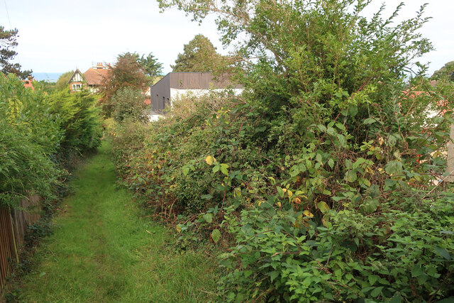
Sheringham Wood is a beautiful woodland located in Norfolk, England. Covering an area of approximately 150 acres, it is a natural haven for wildlife and a popular destination for nature enthusiasts and walkers alike.

The wood is predominantly made up of broadleaf trees, including oak, beech, and silver birch. These tall, majestic trees provide a dense canopy that shelters a variety of flora and fauna. Bluebells, wood anemones, and wild garlic carpet the forest floor during spring, creating a stunning display of color and scent.

Sheringham Wood is home to a diverse range of wildlife. Visitors may spot deer, badgers, and foxes roaming freely, while birdwatchers can observe a plethora of species such as woodpeckers, nuthatches, and tree creepers. The wood is also known for its population of red squirrels, which are a rare sight in many parts of the country.

For those seeking outdoor activities, Sheringham Wood offers a network of well-maintained trails and footpaths. These paths wind through the forest, allowing visitors to explore its hidden corners and discover tranquil spots for picnics or simply to enjoy the peaceful surroundings.

The wood is managed by a local conservation organization, ensuring the preservation of its natural beauty and biodiversity. Educational programs and guided walks are also offered, providing visitors with an opportunity to learn about the wood's history, ecology, and ongoing conservation efforts.

Overall, Sheringham Wood is a treasured natural gem in Norfolk, offering a serene escape from the bustle of everyday life and a chance to connect with the wonders of the natural world.

If you have any feedback on the listing, please let us know in the comments section below.

Sheringham Wood Images

Images are sourced within 2km of 52.928046/1.1811577 or Grid Reference TG1341. Thanks to Geograph Open Source API. All images are credited.

Sheringham Road and West Beckham village sign For more about the village sign see <a title="https://www.geograph.org.uk/photo/6675577" href="https://www.geograph.org.uk/photo/6675577">Link</a>
Sheringham Road and West Beckham village sign
For more about the village sign see Link
East and West Beckham War Memorial The Memorial bears nine names of the men lost in WW1. They are repeated on the Roll of Honour which stands outside the church and is in a very poor condition with the surface of the stone flaking badly. <a title="https://www.geograph.org.uk/photo/2113136" href="https://www.geograph.org.uk/photo/2113136">Link</a>
East and West Beckham War Memorial
The Memorial bears nine names of the men lost in WW1. They are repeated on the Roll of Honour which stands outside the church and is in a very poor condition with the surface of the stone flaking badly. Link
Top of Franklin Hill With sea views limited by growing gorse and trees.
Top of Franklin Hill
With sea views limited by growing gorse and trees.
Path up Franklin Hill A small bump within Sheringham.
Path up Franklin Hill
A small bump within Sheringham.
Building site on the side of Franklin Hill
Steps up Franklin Hill
End of Hooks Hill Road No link through to Uplands Park.
End of Hooks Hill Road
No link through to Uplands Park.
Path down Franklin Hill
North Norfolk Railway Between Sheringham and Weybourne.
North Norfolk Railway
Between Sheringham and Weybourne.
All Saints Church Church at Upper Sheringham.
All Saints Church
Church at Upper Sheringham.
North Norfolk Railway Steam train near Weybourne.
North Norfolk Railway
Steam train near Weybourne.
Sheringham Road Road through Upper Sheringham.
Sheringham Road
Road through Upper Sheringham.
Hall Farm Track to Hall Farm, in Sheringham Park.
Hall Farm
Track to Hall Farm, in Sheringham Park.
Thatched house, Holway Road
Butts Lane off Holway Road Past the new houses.
Butts Lane off Holway Road
Past the new houses.
Butts Lane The southern edge of Sheringham, except for the recently built houses.
Butts Lane
The southern edge of Sheringham, except for the recently built houses.
Field by Butts Lane
Field by Butts Lane
Field by Butts Lane The edge of Sheringham.
Field by Butts Lane
The edge of Sheringham.
Show me another place!

Sheringham Wood is located at Grid Ref: TG1341 (Lat: 52.928046, Lng: 1.1811577)

Administrative County: Norfolk

District: North Norfolk

Police Authority: Norfolk

What 3 Words

///join.relishing.interlude. Near Sheringham, Norfolk

Related Wikis

Sheringham Park

Sheringham Park is a landscape park and gardens near the town of Sheringham, Norfolk, England. The park surrounds Sheringham Hall, lying mostly to its...

Upper Sheringham

Upper Sheringham is a village and a civil parish in the English county of Norfolk. The village is 26.8 miles (43.1 km) north-north-west of Norwich, 6...

Sheringham Woodfields School

Sheringham Woodfields School is a co-educational special school located in Sheringham in the English county of Norfolk.It is a Learning and Cognition Specialist...

Sheringham High School

Sheringham High School is a secondary school and sixth form located in the town of Sheringham in the English county of Norfolk. The school has around 700...

Nearby Amenities

Located within 500m of 52.928046,1.1811577
Sheringham Park, adj
Naptan AtcoCode: 2900S164
Naptan Bearing: N
Naptan BusStopType: CUS
Naptan CommonName: Sheringham Park
Naptan Indicator: adj
Naptan Landmark: park entrance
Naptan Locality: Upper Sheringham
Naptan NaptanCode: nfogpmdw
Naptan Street: Lodge Hill
Naptan Verified: no
Source: naptan_import
Lat/Long: 52.9237571/1.1817846
Sheringham Park, opp
Naptan AtcoCode: 2900S165
Naptan Bearing: S
Naptan BusStopType: CUS
Naptan CommonName: Sheringham Park
Naptan Indicator: opp
Naptan Landmark: park
Naptan Locality: Upper Sheringham
Naptan NaptanCode: nfogpmga
Naptan Street: Lodge Hill
Naptan Verified: no
Source: naptan_import
Lat/Long: 52.9237406/1.1820661
Tourism: viewpoint
Lat/Long: 52.9292093/1.1812446
Caroline's Plantation
Natural: wood
Source: OS_OpenData_StreetView
Lat/Long: 52.9280503/1.1740339
Sheringham Wood
Natural: wood
Source: OS_OpenData_StreetView
Lat/Long: 52.928508/1.1798314
The Bower
Leisure: garden
Tourism: attraction
Lat/Long: 52.9264867/1.1806551
The Temple
Building: yes
Tourism: attraction
Lat/Long: 52.9313189/1.1817726
The Dales
Place: locality
Lat/Long: 52.9319736/1.1846657
Wood Farm
Place: locality
Lat/Long: 52.9254731/1.1809581
Cafe
Courtyard Cafe
Lat/Long: 52.9253509/1.1809557
Information: board
Operator: National Trust
Tourism: information
Lat/Long: 52.9248578/1.1804729
Bench
Lat/Long: 52.9280745/1.1807923
Bench
Backrest: no
Lat/Long: 52.9288838/1.1814514
Tourism: viewpoint
Lat/Long: 52.9298909/1.1763205
Tourism: viewpoint
Lat/Long: 52.9280908/1.1807803
Tourism: viewpoint
Lat/Long: 52.9288988/1.1814671
Bench
Backrest: no
Lat/Long: 52.9288844/1.1814822
Turning Loop
Lat/Long: 52.9315156/1.1850568
Vending Machine
Vending: parking_tickets
Lat/Long: 52.9248333/1.1804885
Charging Station
Hugo-Gino
Capacity: 2
Fee: no
Network: PodPoint
Note: No charge for charging, but usual parking fees apply
Ref: PG-81515
Socket Type2: 2
Socket Type2 Output: 22 kW
Lat/Long: 52.9247047/1.1805797
Entrance: yes
Lat/Long: 52.9254673/1.1813136
Entrance: shop
Lat/Long: 52.9253915/1.1811817
Entrance: shop
Lat/Long: 52.9253569/1.1811171
Hiking: yes
Information: route_marker
Tourism: information
Lat/Long: 52.9324895/1.18178
Power: pole
Lat/Long: 52.9260662/1.1874783
Power: pole
Lat/Long: 52.9250766/1.1866643
Power: pole
Lat/Long: 52.9272304/1.1877693
Power: pole
Lat/Long: 52.9284746/1.1879732
Power: pole
Lat/Long: 52.9296933/1.1878961
The data included in this document is from www.openstreetmap.org. The data is made available under ODbL.

Have you been to Sheringham Wood?

Leave your review of Sheringham Wood below (or comments, questions and feedback).