Fowlmere

Settlement in Cambridgeshire South Cambridgeshire

England

Fowlmere

Former RAF Fowlmere from the air Only 4Km west of RAF Duxford, this <span class="nowrap"><a title="http://en.wikipedia.org/wiki/RAF_Fowlmere" rel="nofollow ugc noopener" href="http://en.wikipedia.org/wiki/RAF_Fowlmere">Link</a><img style="margin-left:2px;" alt="External link" title="External link - shift click to open in new window" src="https://s1.geograph.org.uk/img/external.png" width="10" height="10"/></span> to the Wikipedia article about the base provides more information.
Former RAF Fowlmere from the air Credit: Thomas Nugent

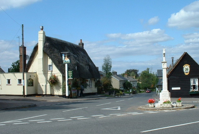
Fowlmere is a small village located in Cambridgeshire, England. It is situated approximately 10 miles south of Cambridge and has a population of around 1,000 residents. The village is known for its picturesque countryside setting, with rolling fields and meadows surrounding the area.

Fowlmere is home to a number of historic buildings, including St. Mary's Church, which dates back to the 13th century. The village also has a primary school, a village hall, and a pub, providing essential amenities for its residents.

The village is surrounded by several nature reserves, making it a popular destination for nature lovers and outdoor enthusiasts. Fowlmere Nature Reserve is particularly well-known for its diverse range of bird species, including kingfishers, bitterns, and water rails.

Overall, Fowlmere offers a peaceful and tranquil setting for those looking to escape the hustle and bustle of city life. Its charming countryside, historic buildings, and natural beauty make it a popular destination for both residents and visitors alike.

If you have any feedback on the listing, please let us know in the comments section below.

Fowlmere Images

Images are sourced within 2km of 52.092563/0.072236 or Grid Reference TL4245. Thanks to Geograph Open Source API. All images are credited.

Former RAF Fowlmere from the air Only 4Km west of RAF Duxford, this <span class="nowrap"><a title="http://en.wikipedia.org/wiki/RAF_Fowlmere" rel="nofollow ugc noopener" href="http://en.wikipedia.org/wiki/RAF_Fowlmere">Link</a><img style="margin-left:2px;" alt="External link" title="External link - shift click to open in new window" src="https://s1.geograph.org.uk/img/external.png" width="10" height="10"/></span> to the Wikipedia article about the base provides more information.
Former RAF Fowlmere from the air
Only 4Km west of RAF Duxford, this LinkExternal link to the Wikipedia article about the base provides more information.
A Grain Store A grain store in Thriplow.
A Grain Store
A grain store in Thriplow.
Thriplow Village Sign The old village sign that represents THRIPLOW
Thriplow Village Sign
The old village sign that represents THRIPLOW
Memorial of Fowlmere The memorial standing to remind you of those who died in the war that lived in FOWLMERE
Memorial of Fowlmere
The memorial standing to remind you of those who died in the war that lived in FOWLMERE
Fowlmere from the air Fowlmere is at the bottom of the photo. Foxton and the chalk quarry at Barrington can be seen in the distance.
Fowlmere from the air
Fowlmere is at the bottom of the photo. Foxton and the chalk quarry at Barrington can be seen in the distance.
Former RAF Fowlmere from the air Only 4Km west of RAF Duxford, this <span class="nowrap"><a title="http://en.wikipedia.org/wiki/RAF_Fowlmere" rel="nofollow ugc noopener" href="http://en.wikipedia.org/wiki/RAF_Fowlmere">Link</a><img style="margin-left:2px;" alt="External link" title="External link - shift click to open in new window" src="https://s1.geograph.org.uk/img/external.png" width="10" height="10"/></span> to the Wikipedia article about the base provides more information.

See also <a href="https://www.geograph.org.uk/photo/2468528">TL4145 : Former RAF Fowlmere from the air</a>.
Former RAF Fowlmere from the air
Only 4Km west of RAF Duxford, this LinkExternal link to the Wikipedia article about the base provides more information. See also TL4145 : Former RAF Fowlmere from the air.
Thriplow Cricket Ground: new nets New practice nets with all-weather wickets are taking shape in the top corner of this attractive ground. The pavilion is in the centre at the far end of the ground. Thriplow was always a good place to play, with fine teas.
Thriplow Cricket Ground: new nets
New practice nets with all-weather wickets are taking shape in the top corner of this attractive ground. The pavilion is in the centre at the far end of the ground. Thriplow was always a good place to play, with fine teas.
Thriplow Cricket Ground Looking towards the Fowlmere Road side of the ground. There is quite a pronounced slope down to the (far) Pavilion End. The square is roped off and looks well prepared for the coming season. March 22 2012 would have been a lovely day for cricket.
Thriplow Cricket Ground
Looking towards the Fowlmere Road side of the ground. There is quite a pronounced slope down to the (far) Pavilion End. The square is roped off and looks well prepared for the coming season. March 22 2012 would have been a lovely day for cricket.
Thriplow: The Old Smithy and the green The village sign - see <a href="https://www.geograph.org.uk/photo/750269">TL4346 : Thriplow Village Sign, detail</a> - has been removed from its maroon post and replaced by a photograph. The daffodils are looking good a few days after the village's 44th Annual Daffodil Weekend.
Thriplow: The Old Smithy and the green
The village sign - see TL4346 : Thriplow Village Sign, detail - has been removed from its maroon post and replaced by a photograph. The daffodils are looking good a few days after the village's 44th Annual Daffodil Weekend.
Thriplow: Lower Street, Bassetts and daffodils This fine 16th-century house is Grade II* listed - see <span class="nowrap"><a title="http://www.britishlistedbuildings.co.uk/en-53126-bassetts-21-thriplow" rel="nofollow ugc noopener" href="http://www.britishlistedbuildings.co.uk/en-53126-bassetts-21-thriplow">Link</a><img style="margin-left:2px;" alt="External link" title="External link - shift click to open in new window" src="https://s1.geograph.org.uk/img/external.png" width="10" height="10"/></span> . The daffodils were looking good a few days after Thriplow's 44th Annual Daffodil Weekend.
Thriplow: Lower Street, Bassetts and daffodils
This fine 16th-century house is Grade II* listed - see LinkExternal link . The daffodils were looking good a few days after Thriplow's 44th Annual Daffodil Weekend.
Thriplow: Middle Street The timber-framed barn on the left is roofed with undulating corrugated iron.
Thriplow: Middle Street
The timber-framed barn on the left is roofed with undulating corrugated iron.
Thriplow: a bend in Middle Street Daffodils were still looking good in the week after Thriplow's Annual Daffodil Weekend.
Thriplow: a bend in Middle Street
Daffodils were still looking good in the week after Thriplow's Annual Daffodil Weekend.
Thriplow: School Lane Looking towards the middle of the village the Thursday after the 44th Annual Daffodil Weekend.
Thriplow: School Lane
Looking towards the middle of the village the Thursday after the 44th Annual Daffodil Weekend.
Eight miles to Cambridge The Fowlmere to Cambridge Turnpike Road dates from 1724-25. It is marked by milestones which date from 1728 and are the work of William Warren, a Fellow of Trinity Hall College. They are thought to be the first milestones to have been erected in Britain since the Roman period. The white stripe on the horizon above the milestone is the chalky summit of Rowley's Hill, a mile and a half or so to the north - at 50m above sea level quite a landmark in these parts.
Eight miles to Cambridge
The Fowlmere to Cambridge Turnpike Road dates from 1724-25. It is marked by milestones which date from 1728 and are the work of William Warren, a Fellow of Trinity Hall College. They are thought to be the first milestones to have been erected in Britain since the Roman period. The white stripe on the horizon above the milestone is the chalky summit of Rowley's Hill, a mile and a half or so to the north - at 50m above sea level quite a landmark in these parts.
Cambridge Road, near Fowlmere Looking towards Newton. The white stripe on the horizon to the left of the trees in the centre is the chalky summit of Rowley's Hill, a mile and a half or so to the north - at 50m above sea level quite a landmark in these parts.
Cambridge Road, near Fowlmere
Looking towards Newton. The white stripe on the horizon to the left of the trees in the centre is the chalky summit of Rowley's Hill, a mile and a half or so to the north - at 50m above sea level quite a landmark in these parts.
Fowlmere High Street in March The north transept and porch of the parish church of St Mary are on the right. This was yet another of the bright and exceptionally warm days in the remarkable early spring of 2012.
Fowlmere High Street in March
The north transept and porch of the parish church of St Mary are on the right. This was yet another of the bright and exceptionally warm days in the remarkable early spring of 2012.
Fowlmere: St Mary "A sizeable cruciform church of flint and pebble rubble, much restored in 1869" (Nikolaus Pevsner). Unusually there is no south aisle. Towers with lead-covered spikes are standard issue in this part of Cambridgeshire (see, for instance, Thriplow and Haslingfield). The picture was taken from the gate at the south-western corner of the churchyard on a bright March morning.
Fowlmere: St Mary
"A sizeable cruciform church of flint and pebble rubble, much restored in 1869" (Nikolaus Pevsner). Unusually there is no south aisle. Towers with lead-covered spikes are standard issue in this part of Cambridgeshire (see, for instance, Thriplow and Haslingfield). The picture was taken from the gate at the south-western corner of the churchyard on a bright March morning.
Fowlmere in spring A view along the High Street towards St Mary's Church on one of the many bright and warm days in the remarkable early spring of 2012.
Fowlmere in spring
A view along the High Street towards St Mary's Church on one of the many bright and warm days in the remarkable early spring of 2012.
Show me another place!

Fowlmere is located at Grid Ref: TL4245 (Lat: 52.092563, Lng: 0.072236)

Administrative County: Cambridgeshire

District: South Cambridgeshire

Police Authority: Cambridgeshire

What 3 Words

///crisper.expensive.switch. Near Fowlmere, Cambridgeshire

Nearby Locations

Fowlmere

Related Wikis

South Cambridgeshire Rural District

South Cambridgeshire was a rural district in Cambridgeshire, England established in 1934 under a County Review Order as a merger of Linton Rural District...

Melbourn Rural District

Melbourn Rural District was a rural district in Cambridgeshire, England, from 1894 to 1934. == Formation == The district had its origins in the Royston...

Fowlmere Airfield

Fowlmere Airfield (ICAO: EGMA) is a small airfield located 4.2 miles (6.8 km) northeast of Royston, Hertfordshire and 8.8 miles (14.2 km) southwest of...

Fowlmere

Fowlmere is one of the southernmost villages in Cambridgeshire, England. The population of the civil parish at the 2011 Census was 1,206. It is very close...

Nearby Amenities

Located within 500m of 52.092563,0.072236
Fowlmere
Is In: Cambridgeshire, England, UK
Place: village
Population: 1200
Source Population: http://www.scambs.gov.uk/CommunityandLiving/VillageServicesAndAmenities/
Wikidata: Q1869427
Lat/Long: 52.089645/0.0756448
Description: Blind corner
Hazard: bend
Lat/Long: 52.0941078/0.0709137
Parking
Addr Street: The Butts
Addr Village: Fowlmere
Capacity: 12
Cctv: no
Covered: no
Description: Free, public car park
Fixme Addr Street: Is this still The Butts?
Motorcar: yes
Source: survey (July 2010)
Lat/Long: 52.0938823/0.0697366
Post Box
Fixme: Collection times?
Ref: SG8 733
Source Ref: survey (October 2010)
Lat/Long: 52.0936123/0.0760857
Barrier: kissing_gate
Bicycle: no
Foot: yes
Wheelchair: no
Lat/Long: 52.0928879/0.0749559
Grit Bin
Access: yes
Lat/Long: 52.0912422/0.0735205
Bus Stop
Chapel Lane
Naptan AtcoCode: 0500SFOWL001
Naptan Bearing: NW
Naptan CommonName: Chapel Lane
Naptan Indicator: opp
Naptan Landmark: Chapel Lane
Naptan NaptanCode: cmbdwdwt
Naptan Street: London Road
Naptan Verified: no
Public Transport: platform
Source: naptan_import
Lat/Long: 52.0906862/0.0726578
Bus Stop
The Butts
Bus Stop: shelter
Description: For services to Cambridge, etc.
Naptan AtcoCode: 0500SFOWL002
Naptan Bearing: N
Naptan CommonName: The Butts
Naptan Indicator: near
Naptan Landmark: The Butts
Naptan NaptanCode: cmbdwgad
Naptan ShortCommonName: The Butts
Naptan Street: High Street
Naptan Verified: yes
Public Transport: platform
Source: naptan_import
Lat/Long: 52.0924208/0.0721591
Bus Stop
The Butts
Naptan AtcoCode: 0500SFOWL003
Naptan Bearing: SW
Naptan CommonName: The Butts
Naptan Indicator: opp
Naptan Landmark: Long Lane
Naptan NaptanCode: cmbdwgag
Naptan ShortCommonName: The Butts
Naptan Street: High Street
Naptan Verified: no
Public Transport: platform
Source: naptan_import
Lat/Long: 52.0927345/0.0727673
Bus Stop
Cambridge Road
Bus Stop: shelter
Description: For services east of this bus stop
Naptan AtcoCode: 0500SFOWL005
Naptan Bearing: NE
Naptan CommonName: Cambridge Road
Naptan Indicator: near
Naptan Landmark: Cambridge Road
Naptan NaptanCode: cmbdwgam
Naptan Street: Thriplow Road
Naptan Verified: no
Public Transport: platform
Source: naptan_import
Lat/Long: 52.0944835/0.0786446
Bus Stop
Chapel Lane
Naptan AtcoCode: 0500SFOWL006
Naptan Bearing: SE
Naptan CommonName: Chapel Lane
Naptan Indicator: near
Naptan Landmark: Chapel Lane
Naptan NaptanCode: cmbdwgap
Naptan Street: London Road
Naptan Verified: no
Public Transport: platform
Source: naptan_import
Lat/Long: 52.0901733/0.0731887
Note: Some kind of water station thingle; I have no clue what, though.
Operator: Anglian Water
Ref: FOWCSP FOWLMERE - CHAPEL LA SP
Source: survey
Lat/Long: 52.0912344/0.0752343
Milestone
Note Ref: 9 miles to Cambridge.
Operator: Trinity Hall, Cambridge
Ref: 9
Source: local_knowledge
Wikidata: Q26420969
Lat/Long: 52.0914018/0.0723705
Building: yes
Description: WW2 generator building
Source: survey
Status: boarded_up;derelict
Lat/Long: 52.0908688/0.0705244
Building: shed
Historic: ruins
Source: survey
Status: derelict
Lat/Long: 52.0909653/0.0705212
Historic: remains
Source: survey
Lat/Long: 52.0906724/0.0712208
Building: remains
Remains: foundations
Source: survey
Lat/Long: 52.0915586/0.0708516
Access Delivery: no
Barrier: kissing_gate
Bicycle: no
Foot: permissive
Wheelchair: no
Lat/Long: 52.091961/0.0699494
Fowlmere War Memorial
Erected: 1919
Historic: memorial
Memorial: war_memorial
Source: Bing
Wikidata: Q26677089
Lat/Long: 52.0925868/0.0723384
The Memorial Well and Pump
Erected: 1911
Historic: memorial
Source: local_knowledge
Lat/Long: 52.0925239/0.0721117
Welding Alloys / Ion Science
Landuse: industrial
Lat/Long: 52.0951755/0.0761746
Give Way
Direction: forward
Lat/Long: 52.0908213/0.0726143
Parking
Capacity: 1
Description: Single-space parking space
Source: survey (August 2010)
Surface: concrete
Lat/Long: 52.0905004/0.0715528
Give Way
Direction: forward
Lat/Long: 52.0903946/0.0730073
Bench
Source: survey (October 2010)
Lat/Long: 52.0931527/0.0750683
Addr Housename: Two Chimneys
Addr Street: High Street
Building: house
Source: survey (October 2010)
Lat/Long: 52.0938151/0.0762977
Parking
Access: private
Description: Large car park on industrial estate
Operator: Ion Science(?)
Source: Bing
Lat/Long: 52.0956164/0.0769013
Addr Street: High Street
Building: house
Note: Possibly also Bridge House
Source: survey (October 2010)
Lat/Long: 52.0936726/0.0768547
Addr Housename: Bridge House
Addr Street: High Street
Building: house
Source: survey (October 2010)
Wikidata: Q26420968
Lat/Long: 52.0936408/0.0767307
Addr Housename: Twentypence
Addr Street: High Street
Source: survey (October 2010)
Lat/Long: 52.094061/0.0771365
Addr Housename: Timbers
Addr Street: High Street
Source: survey (October 2010)
Lat/Long: 52.0939983/0.0769571
Addr Street: High Street
Building: house
Description: House under construction
Source: survey (October 2010)
Lat/Long: 52.0940046/0.0775855
Ryecroft Data
Addr Housename: Graphics House
Addr Street: High Street
Shop: copyshop
Source: survey (October 2010)
Lat/Long: 52.0937888/0.0761047
Addr Housename: Clifton House
Addr Street: High Street
Building: house
Source: survey (October 2010)
Lat/Long: 52.0940958/0.0777866
Power: pole
Source: Bing
Lat/Long: 52.0957669/0.0773329
Street Lamp
Source: Bing
Lat/Long: 52.0915064/0.0739512
Note: The houses aren't connected, but there's only a couple of inches in it. Source: I almost live here.
Lat/Long: 52.0914265/0.0737735
Street Lamp
Source: Bing
Lat/Long: 52.091258/0.0734504
Fixme: What house number is this?
Lat/Long: 52.0900981/0.0734089
Fixme: What house number is this?
Lat/Long: 52.0886782/0.0747342
Street Lamp
Source: local_knowledge
Lat/Long: 52.0912847/0.074086
Give Way
Lat/Long: 52.0945599/0.0713816
Give Way
Lat/Long: 52.0926945/0.072476
Generator Method: photovoltaic
Generator Output Electricity: 3 kW
Generator Source: solar
Generator Type: solar_photovoltaic_panel
Power: generator
Lat/Long: 52.0933982/0.0700338
Generator Method: photovoltaic
Generator Output Electricity: 3 kW
Generator Source: solar
Generator Type: solar_photovoltaic_panel
Power: generator
Lat/Long: 52.0932095/0.0695443
Generator Method: photovoltaic
Generator Output Electricity: 3 kW
Generator Source: solar
Generator Type: solar_photovoltaic_panel
Power: generator
Lat/Long: 52.0931856/0.0694478
Generator Method: photovoltaic
Generator Output Electricity: 2 KW
Generator Source: solar
Generator Type: solar_photovoltaic_panel
Power: generator
Lat/Long: 52.0930571/0.0689395
Bicycle Parking
Access: yes
Bicycle Parking: stands
Capacity: 6
Covered: no
Cyclestreets Id: 194870
Fee: no
Lat/Long: 52.0932445/0.0702634
Waste Basket
Lat/Long: 52.0932556/0.0702966
Advertising: board
Lat/Long: 52.0932359/0.0703136
The data included in this document is from www.openstreetmap.org. The data is made available under ODbL.

Have you been to Fowlmere?

Leave your review of Fowlmere below (or comments, questions and feedback).