Ben Hunt's Plantation

Wood, Forest in Suffolk Mid Suffolk

England

Ben Hunt's Plantation

Field next to Colsey Wood
Field next to Colsey Wood Credit: Chris Holifield

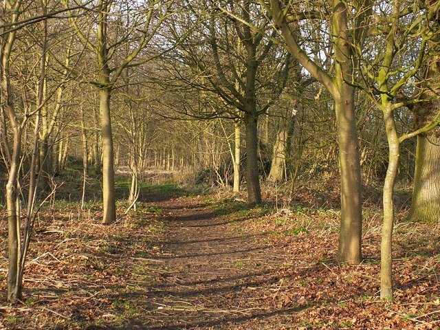
Ben Hunt's Plantation, located in Suffolk, is a picturesque woodland area known for its serene and natural beauty. Covering a vast expanse, it is a popular destination for nature enthusiasts and outdoor lovers alike. The plantation is named after its owner, Ben Hunt, who has dedicated his efforts to preserving and maintaining the area's unique ecosystem.

The woodland is characterized by a rich diversity of flora and fauna. Towering trees, including oak, beech, and pine, dominate the landscape, offering a cool and shaded environment during hot summer months. The forest floor is covered in a thick carpet of moss and ferns, creating a lush and enchanting atmosphere.

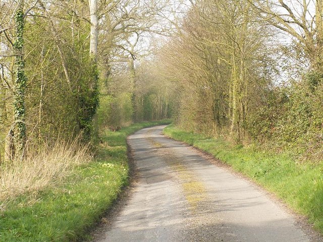
Visitors to Ben Hunt's Plantation can explore numerous walking trails that wind their way through the woodland. These trails offer an opportunity to immerse oneself in nature and enjoy the peaceful sounds of birdsong and rustling leaves. Along the paths, benches and picnic areas are strategically placed, providing visitors with the perfect spot to rest and take in the scenic views.

The plantation is also home to a variety of wildlife species. Deer, rabbits, and squirrels are commonly spotted, while birdwatchers can observe a wide array of avian species, including woodpeckers, owls, and songbirds.

Ben Hunt's Plantation is open to the public year-round, allowing visitors to experience the changing seasons and witness the vibrant colors of autumn or the blooming flowers of spring. It serves as a tranquil oasis, offering a retreat from the hustle and bustle of city life and a chance to reconnect with nature.

If you have any feedback on the listing, please let us know in the comments section below.

Ben Hunt's Plantation Images

Images are sourced within 2km of 52.294395/1.0792437 or Grid Reference TM1070. Thanks to Geograph Open Source API. All images are credited.

Field next to Colsey Wood
Church of St Andrew, Wickham Skeith <span class="nowrap"><a title="https://historicengland.org.uk/listing/the-list/list-entry/1352521?section=official-list-entry" rel="nofollow ugc noopener" href="https://historicengland.org.uk/listing/the-list/list-entry/1352521?section=official-list-entry">Link</a><img style="margin-left:2px;" alt="External link" title="External link - shift click to open in new window" src="https://s1.geograph.org.uk/img/external.png" width="10" height="10"/></span>
Church of St Andrew, Wickham Skeith
Rood Loft Stair at Church of St Andrew, Wickham Skeith <span class="nowrap"><a title="https://historicengland.org.uk/listing/the-list/list-entry/1352521?section=official-list-entry" rel="nofollow ugc noopener" href="https://historicengland.org.uk/listing/the-list/list-entry/1352521?section=official-list-entry">Link</a><img style="margin-left:2px;" alt="External link" title="External link - shift click to open in new window" src="https://s1.geograph.org.uk/img/external.png" width="10" height="10"/></span>
Rood Loft Stair at Church of St Andrew, Wickham Skeith
Font at Church of St Andrew, Wickham Skeith <span class="nowrap"><a title="https://historicengland.org.uk/listing/the-list/list-entry/1352521?section=official-list-entry" rel="nofollow ugc noopener" href="https://historicengland.org.uk/listing/the-list/list-entry/1352521?section=official-list-entry">Link</a><img style="margin-left:2px;" alt="External link" title="External link - shift click to open in new window" src="https://s1.geograph.org.uk/img/external.png" width="10" height="10"/></span>
Font at Church of St Andrew, Wickham Skeith
Doorway at Church of St Andrew, Wickham Skeith <span class="nowrap"><a title="https://historicengland.org.uk/listing/the-list/list-entry/1352521?section=official-list-entry" rel="nofollow ugc noopener" href="https://historicengland.org.uk/listing/the-list/list-entry/1352521?section=official-list-entry">Link</a><img style="margin-left:2px;" alt="External link" title="External link - shift click to open in new window" src="https://s1.geograph.org.uk/img/external.png" width="10" height="10"/></span>
Doorway at Church of St Andrew, Wickham Skeith
Footpath from Thornham Magna to Wickham Skeith
Stoke Ash Primary School Stoke Ash School is on a tiny no through road, separated from the village by the very busy A140. The original victorian school building was extended in the 1950's. The school playing field extends beyond the building.
Stoke Ash Primary School
Stoke Ash School is on a tiny no through road, separated from the village by the very busy A140. The original victorian school building was extended in the 1950's. The school playing field extends beyond the building.
Blue Skies And Green Grass Country view photo taken east of Wickham Skeith Suffolk.
Blue Skies And Green Grass
Country view photo taken east of Wickham Skeith Suffolk.
To Norwich 26 Old milestone on the A140 at Stoke Ash, Suffolk. For close up view see <a title="https://www.geograph.org.uk/photo/1206015" href="https://www.geograph.org.uk/photo/1206015">Link</a> For more info about the stone see <span class="nowrap"><a title="http://milestones.megalithia.com/sites/tm113712.htm" rel="nofollow ugc noopener" href="http://milestones.megalithia.com/sites/tm113712.htm">Link</a><img style="margin-left:2px;" alt="External link" title="External link - shift click to open in new window" src="https://s1.geograph.org.uk/img/external.png" width="10" height="10"/></span> and do have a look at their home page. This is one of a series of mileposts that follow the A140 see <a title="https://www.geograph.org.uk/search.php?i=9240043&displayclass=full" href="https://www.geograph.org.uk/search.php?i=9240043&displayclass=full">Link</a>
To Norwich 26
Old milestone on the A140 at Stoke Ash, Suffolk. For close up view see Link For more info about the stone see LinkExternal link and do have a look at their home page. This is one of a series of mileposts that follow the A140 see Link
Old Milestone Old milestone on the A140 at Stoke Ash, Suffolk. For overall view see <a title="https://www.geograph.org.uk/photo/1206010" href="https://www.geograph.org.uk/photo/1206010">Link</a> For more info on the stone see <span class="nowrap"><a title="http://milestones.megalithia.com/sites/tm113712.htm" rel="nofollow ugc noopener" href="http://milestones.megalithia.com/sites/tm113712.htm">Link</a><img style="margin-left:2px;" alt="External link" title="External link - shift click to open in new window" src="https://s1.geograph.org.uk/img/external.png" width="10" height="10"/></span> and do have a look at their home page. This is one of a series of mileposts that follow the A140 see <a title="https://www.geograph.org.uk/search.php?i=9240043&displayclass=full" href="https://www.geograph.org.uk/search.php?i=9240043&displayclass=full">Link</a>
Old Milestone
Old milestone on the A140 at Stoke Ash, Suffolk. For overall view see Link For more info on the stone see LinkExternal link and do have a look at their home page. This is one of a series of mileposts that follow the A140 see Link
Farm track through pastures at Wickham Skeith The track serves as a public footpath.
Farm track through pastures at Wickham Skeith
The track serves as a public footpath.
Footpath to Wickham Skeith This public footpath follows a track and links Colsey Wood with Wickham Skeith. The trees seen in the background surround St Andrew's church, a dry ford can be seen in the foreground.
Footpath to Wickham Skeith
This public footpath follows a track and links Colsey Wood with Wickham Skeith. The trees seen in the background surround St Andrew's church, a dry ford can be seen in the foreground.
Wickham Skeith church
Railway Bridge This brick railway bridge carries the Norwich to London main line and it blends well into the surrounding wooded countryside between Gislinham and Thornham Magna.
Railway Bridge
This brick railway bridge carries the Norwich to London main line and it blends well into the surrounding wooded countryside between Gislinham and Thornham Magna.
Path on the Thornham Estate Thornham Estate is a beautiful place to walk and is open to the public each day. There are 12 miles of footpaths through ancient parkland, woodland, farmland and water meadows.
Path on the Thornham Estate
Thornham Estate is a beautiful place to walk and is open to the public each day. There are 12 miles of footpaths through ancient parkland, woodland, farmland and water meadows.
Harry Potter's Wife's Grave The grave of Emma Potter the late wife of Harry Potter in the churchyard at Wickham Skeith, Suffolk.
Harry Potter's Wife's Grave
The grave of Emma Potter the late wife of Harry Potter in the churchyard at Wickham Skeith, Suffolk.
Star House Lane
Star House Lane
To Dormans Wood Footpath to Dormans Wood from Clay Street near to Wickham Street Suffolk.
To Dormans Wood
Footpath to Dormans Wood from Clay Street near to Wickham Street Suffolk.
Show me another place!

Ben Hunt's Plantation is located at Grid Ref: TM1070 (Lat: 52.294395, Lng: 1.0792437)

Administrative County: Suffolk

District: Mid Suffolk

Police Authority: Suffolk

What 3 Words

///defectors.proud.insect. Near Bacton, Suffolk

Related Wikis

Thornham Magna

Thornham Magna is the larger sister village of Thornham Parva on the former estate of Thornham Hall, the Henniker family seat, in Suffolk. It is about...

Hartismere Hundred

Hartismere was a hundred of Suffolk, that later gave its name to a poor law union, a rural sanitary district, and the Hartismere Rural District. Listed...

Stoke Ash

Stoke Ash is a village and civil parish in the Mid Suffolk district of Suffolk in eastern England. Located around six miles south of Diss, in 2011 its...

Wickham Skeith

Wickham Skeith is a village and civil parish in Suffolk, England, about 5 miles to the west of Eye and about 3 miles east of Finningham. == History... ==

Gislingham

Gislingham is a village and civil parish in the Mid Suffolk district of Suffolk in eastern England. == History == Gislingham is situated around the area...

St Mary's Church, Thornham Parva

St Mary's Church is a medieval church in Thornham Parva, Suffolk, England. Much of the fabric dates from the 12th century, and it is a Grade I listed building...

Thornham Parva

Thornham Parva is a village and civil parish in the Mid Suffolk district of Suffolk in eastern England. Located to the north of sister village Thornham...

Pye Road

Pye Road is a Roman road running from the capital of the Iceni at Venta Icenorum (Caistor St Edmund near Norwich) to the original Roman provincial capital...

Nearby Amenities

Located within 500m of 52.294395,1.0792437
Bus Stop
Four Horseshoes
Bus: yes
Naptan AtcoCode: 390040173
Naptan Bearing: E
Naptan BusStopType: CUS
Naptan CommonName: Four Horseshoes
Naptan Indicator: E-bound
Naptan Landmark: Four Horseshoes
Naptan NaptanCode: sufawdtp
Naptan Street: Workhouse Road
Naptan Verified: no
Public Transport: platform
Source: naptan_import
Lat/Long: 52.294281/1.08428
Bus Stop
Four Horseshoes
Bus: yes
Naptan AtcoCode: 390040174
Naptan Bearing: W
Naptan CommonName: Four Horseshoes
Naptan Indicator: W-bound
Naptan Landmark: Four Horseshoes
Naptan NaptanCode: sufawdtw
Naptan Street: Workhouse Road
Naptan Verified: no
Public Transport: platform
Source: naptan_import
Lat/Long: 52.2941595/1.0841102
Bus Stop
Four Horseshoes
Bus: yes
Naptan AtcoCode: 390040809
Naptan Bearing: N
Naptan BusStopType: CUS
Naptan CommonName: Four Horseshoes
Naptan Indicator: N-bound
Naptan Landmark: Four Horseshoes
Naptan NaptanCode: sufjgajt
Naptan Street: The Street
Naptan Verified: no
Public Transport: platform
Source: naptan_import
Lat/Long: 52.2945068/1.084589
Bus Stop
Four Horseshoes
Bus: yes
Naptan AtcoCode: 390040810
Naptan Bearing: S
Naptan BusStopType: CUS
Naptan CommonName: Four Horseshoes
Naptan Indicator: S-bound
Naptan Landmark: Four Horseshoes
Naptan NaptanCode: sufjgajw
Naptan Street: The Street
Naptan Verified: no
Public Transport: platform
Source: naptan_import
Lat/Long: 52.2945501/1.0846507
Public Bookcase
BookSwap
Booth: K6
Check Date: 2024-03-31
Colour: red
Disused Amenity: telephone
Man Made: telephone_box
Opening Hours: 24/7
Operator: community
Public Bookcase Type: phone_box
Lat/Long: 52.2978668/1.0838243
Defibrillator
Addr City: Eye
Addr Postcode: IP23 8HB
Addr Street: The Street
Addr Village: Thornham Magna
Defibrillator Location: Wall behind Red Phone Box Library
Emergency: defibrillator
Indoor: no
Ref GB The Circuit: 8D170CC9-A756-40E7-9EC4-B02E00E09EA1
Lat/Long: 52.2978568/1.0837915
Give Way
Lat/Long: 52.2942743/1.0847417
Give Way
Lat/Long: 52.2937259/1.0818926
Give Way
Lat/Long: 52.2937997/1.0820153
Thornham Magna
Traffic Sign: city_limit
Lat/Long: 52.2924397/1.0817336
Give Way
Lat/Long: 52.2943292/1.0846586
Post Box
Collection Times: Mo-Fr 09:00; Sa 09:00
Operator: Royal Mail
Post Box Type: wall
Ref: IP23 7062
Royal Cypher: GR
Royal Cypher Wikidata: Q33102273
Lat/Long: 52.2974667/1.0841266
Addr Housename: Lamb's Farm
Addr Place: Fornham Magna
Building: house
Lat/Long: 52.2977038/1.0835896
Addr Housename: Wisteria Barn
Addr Place: Fornham Magna
Building: house
Lat/Long: 52.2974389/1.0844091
Addr Housename: Gardener's Cottage
Addr Place: Fornham Magna
Building: house
Lat/Long: 52.2973618/1.0841864
Addr Housename: The Old Wash House
Addr Housenumber: 202
Addr Place: Fornham Magna
Building: house
Lat/Long: 52.2971133/1.0842334
Addr Housename: Brook House
Addr Place: Fornham Magna
Building: house
Lat/Long: 52.2969952/1.0842682
Addr Housename: Brambles
Addr Place: Fornham Magna
Building: house
Lat/Long: 52.2965195/1.084515
Addr Place: Fornham Magna
Building: house
Lat/Long: 52.2964374/1.0845311
Addr Housename: Little Street Farm
Addr Place: Fornham Magna
Lat/Long: 52.295591/1.0842401
The data included in this document is from www.openstreetmap.org. The data is made available under ODbL.

Have you been to Ben Hunt's Plantation?

Leave your review of Ben Hunt's Plantation below (or comments, questions and feedback).