Hazel Wood

Wood, Forest in Norfolk Broadland

England

Hazel Wood

Head Shunt The station yard of the heritage Whitwell & Reepham Railway
Head Shunt Credit: Kevin Waterhouse

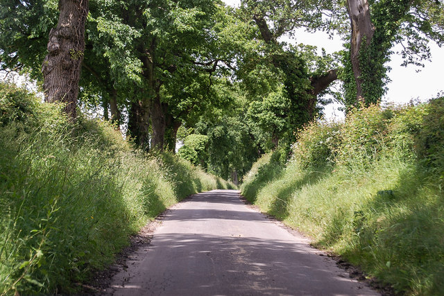
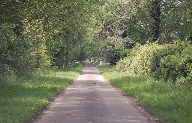
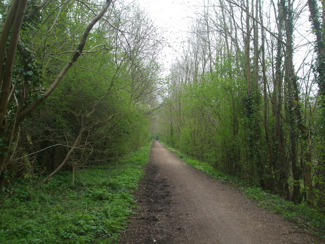
Hazel Wood, located in Norfolk, England, is a picturesque forest that spans an area of approximately 500 acres. This ancient woodland is renowned for its stunning natural beauty and diverse range of flora and fauna. The wood is predominantly composed of mature hazel trees, giving it its name, but it also features a mix of other tree species such as oak, ash, and birch.

Walking through Hazel Wood is a truly enchanting experience. The forest floor is carpeted with a lush layer of ferns, bluebells, and wild garlic, creating a vibrant and colorful atmosphere. The canopy formed by the towering trees provides a cool and shady retreat during the hot summer months.

The wood is home to a variety of wildlife, making it a haven for nature lovers and birdwatchers. Visitors may catch glimpses of deer, foxes, and rabbits darting between the trees, while bird species such as woodpeckers, owls, and warblers can be heard singing their melodic tunes.

Hazel Wood also offers several designated walking trails, allowing visitors to explore its wonders at their own pace. These trails are well-maintained and provide informative signage about the different tree species and wildlife that can be found in the area.

In addition to its natural beauty, Hazel Wood holds cultural and historical significance. It has been a cherished location for local communities for generations, with tales and legends associated with its ancient trees and mystical atmosphere.

Overall, Hazel Wood in Norfolk is a true gem of natural beauty, offering visitors a tranquil escape from the hustle and bustle of modern life.

If you have any feedback on the listing, please let us know in the comments section below.

Hazel Wood Images

Images are sourced within 2km of 52.74385/1.1048247 or Grid Reference TG0920. Thanks to Geograph Open Source API. All images are credited.

Head Shunt The station yard of the heritage Whitwell & Reepham Railway
Head Shunt
The station yard of the heritage Whitwell & Reepham Railway
Station Entrance On the heritage Whitwell & Reepham Railway
Station Entrance
On the heritage Whitwell & Reepham Railway
Reepham: Collecting the baled straw from a harvested cereal crop
Reepham: Harvested cereal crop
Unnamed lane near Great Witchingham Heading towards Whitwell.
Unnamed lane near Great Witchingham
Heading towards Whitwell.
Blackwater Lane towards Sparham
Mill Road, Whitwell At the junction with Mill Road
Mill Road, Whitwell
At the junction with Mill Road
Mill Road & footpath Near Malthouse Farm
Mill Road & footpath
Near Malthouse Farm
Reepham and Whitwell cemetery The cemetery contains four War Graves
Reepham and Whitwell cemetery
The cemetery contains four War Graves
Clayhall Farm near Great Witchingham As agriculture becomes more and more mechanised, indeed industrialised, farms like this one are becoming more common.
Clayhall Farm near Great Witchingham
As agriculture becomes more and more mechanised, indeed industrialised, farms like this one are becoming more common.
Great Witchingham Wildlife Park is now "The Animal Ark" This park has changed its approach and you will be redirected. The focus is now on pets and farm animals.  This photo is taken from the car park.
Great Witchingham Wildlife Park is now "The Animal Ark"
This park has changed its approach and you will be redirected. The focus is now on pets and farm animals. This photo is taken from the car park.
Marriott's Way near Blackwater, looking south-east This section of the Way (footpath and cycleway) is close to the point where it loops back towards Reepham at Themelthorpe <a href="https://www.geograph.org.uk/gridref/TG0623">TG0623</a>. It is close to the weak bridge in <a href="https://www.geograph.org.uk/gridref/TG0920">TG0920</a>.
Marriott's Way near Blackwater, looking south-east
This section of the Way (footpath and cycleway) is close to the point where it loops back towards Reepham at Themelthorpe TG0623. It is close to the weak bridge in TG0920.
Cattle pasture by Sparham House
The Animal Ark Entrance to The Animal Ark viewed from across its car park - what used to be the Witchingham Wildlife Park, and the Norfolk Wildlife Centre & Country Park before that, is presently The Animal Ark.
The Animal Ark
Entrance to The Animal Ark viewed from across its car park - what used to be the Witchingham Wildlife Park, and the Norfolk Wildlife Centre & Country Park before that, is presently The Animal Ark.
The Animal Ark - sign What used to be the Witchingham Wildlife Park, and the Norfolk Wildlife Centre & Country Park before that, is presently The Animal Ark.
The Animal Ark - sign
What used to be the Witchingham Wildlife Park, and the Norfolk Wildlife Centre & Country Park before that, is presently The Animal Ark.
Building by the entrance of The Animal Ark What used to be the Witchingham Wildlife Park, and the Norfolk Wildlife Centre & Country Park before that, is presently The Animal Ark. See also > <a title="https://www.geograph.org.uk/photo/899763" href="https://www.geograph.org.uk/photo/899763">Link</a>.
Building by the entrance of The Animal Ark
What used to be the Witchingham Wildlife Park, and the Norfolk Wildlife Centre & Country Park before that, is presently The Animal Ark. See also > Link.
The Animal Ark - closed today What used to be the Witchingham Wildlife Park, and the Norfolk Wildlife Centre & Country Park before that, is presently The Animal Ark. See also > <a title="https://www.geograph.org.uk/photo/899763" href="https://www.geograph.org.uk/photo/899763">Link</a>. But on this sunny Sunday afternoon in late July the gates were closed. See also > <a title="https://www.geograph.org.uk/photo/527929" href="https://www.geograph.org.uk/photo/527929">Link</a>.
The Animal Ark - closed today
What used to be the Witchingham Wildlife Park, and the Norfolk Wildlife Centre & Country Park before that, is presently The Animal Ark. See also > Link. But on this sunny Sunday afternoon in late July the gates were closed. See also > Link.
Norfolk Wildlife Park in the late seventies Those were the days when the Norfolk Wildlife Park offered wildlife that children could easily see.
Norfolk Wildlife Park in the late seventies
Those were the days when the Norfolk Wildlife Park offered wildlife that children could easily see.
Show me another place!

Hazel Wood is located at Grid Ref: TG0920 (Lat: 52.74385, Lng: 1.1048247)

Administrative County: Norfolk

District: Broadland

Police Authority: Norfolk

What 3 Words

///agreeing.printer.mural. Near Reepham, Norfolk

Nearby Locations

Hazel Wood Fiddler's Hill

Related Wikis

Whitwell & Reepham railway station

Whitwell and Reepham railway station, also known as Whitwell station, is a former station situated in Norfolk, England. The station closed in 1959 and...

Whitwell Common SSSI

Whitwell Common is a 19.4-hectare (48-acre) biological Site of Special Scientific Interest north-east of Dereham in Norfolk.This common in the valley...

Great Witchingham

Great Witchingham is a village and civil parish in the English county of Norfolk about 11 miles (18 km) north-west of Norwich. It covers an area of 9.12...

Reepham High School and College

Reepham High School and College is a secondary school and sixth form with academy status located in Reepham, Norfolk. The majority of the students live...

St Faith's Church, Little Witchingham

St Faith's Church is a redundant Anglican church in the village of Little Witchingham in Norfolk, England. It is recorded in the National Heritage List...

Reepham, Norfolk

Reepham () is a market town and civil parish in the Broadland district of Norfolk, England. Reepham is situated on the B1145 road between the Bure and...

Little Witchingham

Little Witchingham is a village and civil parish in the English county of Norfolk. It covers an area of 3.01 km2 (1.16 sq mi) and had a population of 36...

River Ainse (or Eyn)

The River Ainse (or Eyn) is a small river in the county of Norfolk. It is a tributary of the River Wensum which it merges with at Lenwade. The River Ainse...

Nearby Amenities

Located within 500m of 52.74385,1.1048247
The data included in this document is from www.openstreetmap.org. The data is made available under ODbL.

Have you been to Hazel Wood?

Leave your review of Hazel Wood below (or comments, questions and feedback).