Blean Wood

Wood, Forest in Kent Swale

England

Blean Wood

Ordnance Survey Flush Bracket S6173 This can be found on the roadside wall of the former primary school in Dunkirk.
For more detail see : <span class="nowrap"><a title="http://www.bench-marks.org.uk/bm19720" rel="nofollow ugc noopener" href="http://www.bench-marks.org.uk/bm19720">Link</a><img style="margin-left:2px;" alt="External link" title="External link - shift click to open in new window" src="https://s1.geograph.org.uk/img/external.png" width="10" height="10"/></span>
Ordnance Survey Flush Bracket S6173 Credit: Peter Wood

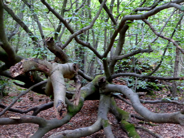
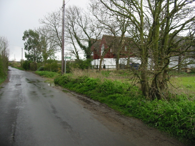
Blean Wood, located in Kent, England, is a picturesque forest that spans over 1,000 hectares. It is one of the largest areas of ancient woodland in the southeastern region of the country. The wood is situated just a few miles north of the historic city of Canterbury and is easily accessible to both locals and tourists.

Blean Wood boasts an impressive variety of plant and animal species, making it a haven for nature enthusiasts and wildlife lovers. The forest is predominantly made up of oak and sweet chestnut trees, with pockets of coniferous plantations scattered throughout. Bluebells, wood anemones, and wild garlic create a stunning carpet of color during the spring months.

The wood is home to numerous bird species, including nightingales, woodpeckers, and tawny owls. Visitors may also spot mammals such as badgers, deer, and foxes while exploring the forest trails. Blean Wood is part of the Blean Complex, an important ecological network that provides a crucial habitat for various rare and endangered species.

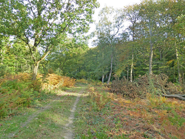
The forest offers a range of recreational activities for visitors to enjoy. There are well-maintained walking and cycling trails that allow visitors to explore the beauty of the wood at their own pace. Additionally, the wood has several designated picnic areas, making it an ideal spot for a family day out.

Blean Wood is not only a natural treasure but also holds historical significance. It was once a source of timber for the shipbuilding industry during the Tudor period. Today, it is managed by the Forestry Commission, who work tirelessly to preserve its ecological and historical value for future generations to appreciate.

If you have any feedback on the listing, please let us know in the comments section below.

Blean Wood Images

Images are sourced within 2km of 51.307831/0.98543921 or Grid Reference TR0860. Thanks to Geograph Open Source API. All images are credited.

Ordnance Survey Flush Bracket S6173 This can be found on the roadside wall of the former primary school in Dunkirk.
For more detail see : <span class="nowrap"><a title="http://www.bench-marks.org.uk/bm19720" rel="nofollow ugc noopener" href="http://www.bench-marks.org.uk/bm19720">Link</a><img style="margin-left:2px;" alt="External link" title="External link - shift click to open in new window" src="https://s1.geograph.org.uk/img/external.png" width="10" height="10"/></span>
Ordnance Survey Flush Bracket S6173
This can be found on the roadside wall of the former primary school in Dunkirk. For more detail see : LinkExternal link
Mount Ephraim Gardens The house was originally built in 1695, then rebuilt in 1878 and then extended in 1913. The gardens were laid out in the Edwardian era, but after wartime neglect (when most adult men were enlisted in wartime services) were substantially restored from the early 1950s. See <span class="nowrap"><a title="http://www.mountephraimgardens.co.uk/the-gardens/" rel="nofollow ugc noopener" href="http://www.mountephraimgardens.co.uk/the-gardens/">Link</a><img style="margin-left:2px;" alt="External link" title="External link - shift click to open in new window" src="https://s1.geograph.org.uk/img/external.png" width="10" height="10"/></span>  for more information.
Mount Ephraim Gardens
The house was originally built in 1695, then rebuilt in 1878 and then extended in 1913. The gardens were laid out in the Edwardian era, but after wartime neglect (when most adult men were enlisted in wartime services) were substantially restored from the early 1950s. See LinkExternal link for more information.
View from the tea room at Mount Ephraim Gardens The house was originally built in 1695, then rebuilt in 1878 and then extended in 1913. The gardens were laid out in the Edwardian era, but after wartime neglect (when most adult men were enlisted in wartime services) were substantially restored from the early 1950s. See <span class="nowrap"><a title="http://www.mountephraimgardens.co.uk/the-gardens/" rel="nofollow ugc noopener" href="http://www.mountephraimgardens.co.uk/the-gardens/">Link</a><img style="margin-left:2px;" alt="External link" title="External link - shift click to open in new window" src="https://s1.geograph.org.uk/img/external.png" width="10" height="10"/></span>  for more information.
View from the tea room at Mount Ephraim Gardens
The house was originally built in 1695, then rebuilt in 1878 and then extended in 1913. The gardens were laid out in the Edwardian era, but after wartime neglect (when most adult men were enlisted in wartime services) were substantially restored from the early 1950s. See LinkExternal link for more information.
The Topiary Garden at Mount Ephraim Gardens The house was originally built in 1695, then rebuilt in 1878 and then extended in 1913. The gardens were laid out in the Edwardian era, but after wartime neglect (when most adult men were enlisted in wartime services) were substantially restored from the early 1950s. See <span class="nowrap"><a title="http://www.mountephraimgardens.co.uk/the-gardens/" rel="nofollow ugc noopener" href="http://www.mountephraimgardens.co.uk/the-gardens/">Link</a><img style="margin-left:2px;" alt="External link" title="External link - shift click to open in new window" src="https://s1.geograph.org.uk/img/external.png" width="10" height="10"/></span> for more information.

This is the Topiary Garden looking towards the 1913 extension to the house.
The Topiary Garden at Mount Ephraim Gardens
The house was originally built in 1695, then rebuilt in 1878 and then extended in 1913. The gardens were laid out in the Edwardian era, but after wartime neglect (when most adult men were enlisted in wartime services) were substantially restored from the early 1950s. See LinkExternal link for more information. This is the Topiary Garden looking towards the 1913 extension to the house.
Plaque in the tea room at Mount Ephraim Gardens Anyone visiting the tea room at Mount Ephraim Gardens will find this on the wall and several pictures of the event - see also <a title="https://www.geograph.org.uk/photo/5029135" href="https://www.geograph.org.uk/photo/5029135">Link</a>  in Hernhill Churchyard.

For further details and full accounts see <span class="nowrap"><a title="https://en.wikipedia.org/wiki/Battle_of_Bossenden_Wood" rel="nofollow ugc noopener" href="https://en.wikipedia.org/wiki/Battle_of_Bossenden_Wood">Link</a><img style="margin-left:2px;" alt="External link" title="External link - shift click to open in new window" src="https://s1.geograph.org.uk/img/external.png" width="10" height="10"/></span>   and <span class="nowrap"><a title="http://hernhill.net/about-hernhill/battle-of-bossenden-wood/" rel="nofollow ugc noopener" href="http://hernhill.net/about-hernhill/battle-of-bossenden-wood/">Link</a><img style="margin-left:2px;" alt="External link" title="External link - shift click to open in new window" src="https://s1.geograph.org.uk/img/external.png" width="10" height="10"/></span>
Plaque in the tea room at Mount Ephraim Gardens
Anyone visiting the tea room at Mount Ephraim Gardens will find this on the wall and several pictures of the event - see also Link in Hernhill Churchyard. For further details and full accounts see LinkExternal link and LinkExternal link
Mount Ephraim House Grade II listed <span class="nowrap"><a title="https://www.historicengland.org.uk/listing/the-list/list-entry/1069118" rel="nofollow ugc noopener" href="https://www.historicengland.org.uk/listing/the-list/list-entry/1069118">Link</a><img style="margin-left:2px;" alt="External link" title="External link - shift click to open in new window" src="https://s1.geograph.org.uk/img/external.png" width="10" height="10"/></span>
Mount Ephraim House
Grade II listed LinkExternal link
Track in Bossenden Wood, Dunkirk It was in this wood in 1835 that what is thought to be the last battle on English soil took place. During a period of unrest a group of rural labourers led by John Tom, who called himself Sir William Courtenay, entered into battle with soldiers after Courtenay had murdered a local constable. A total of 11 men were killed including 8 of Courtenay's followers.
Track in Bossenden Wood, Dunkirk
It was in this wood in 1835 that what is thought to be the last battle on English soil took place. During a period of unrest a group of rural labourers led by John Tom, who called himself Sir William Courtenay, entered into battle with soldiers after Courtenay had murdered a local constable. A total of 11 men were killed including 8 of Courtenay's followers.
Cleared woodland in Bossenden Wood, Dunkirk
Dead tree by a path in Bossenden Wood, Dunkirk It was in this wood in 1835 that what is thought to be the last battle on English soil took place. During a period of unrest a group of rural labourers led by John Tom, who called himself Sir William Courtenay, entered into battle with soldiers after Courtenay had murdered a local constable. A total of 11 men were killed including 8 of Courtenay's followers.
Dead tree by a path in Bossenden Wood, Dunkirk
It was in this wood in 1835 that what is thought to be the last battle on English soil took place. During a period of unrest a group of rural labourers led by John Tom, who called himself Sir William Courtenay, entered into battle with soldiers after Courtenay had murdered a local constable. A total of 11 men were killed including 8 of Courtenay's followers.
Fungi on a tree stump, Bossenden Wood, Dunkirk It was in this wood in 1835 that what is thought to be the last battle on English soil took place. During a period of unrest a group of rural labourers led by John Tom, who called himself Sir William Courtenay, entered into battle with soldiers after Courtenay had murdered a local constable. A total of 11 men were killed including 8 of Courtenay's followers.
Fungi on a tree stump, Bossenden Wood, Dunkirk
It was in this wood in 1835 that what is thought to be the last battle on English soil took place. During a period of unrest a group of rural labourers led by John Tom, who called himself Sir William Courtenay, entered into battle with soldiers after Courtenay had murdered a local constable. A total of 11 men were killed including 8 of Courtenay's followers.
The Topiary Garden, Mount Ephraim Mount Ephraim house was originally built in 1695, then rebuilt in 1878 and extended in 1913. The gardens were laid out in the Edwardian era and have been substantially restored since the early 1950s.
The Topiary Garden, Mount Ephraim
Mount Ephraim house was originally built in 1695, then rebuilt in 1878 and extended in 1913. The gardens were laid out in the Edwardian era and have been substantially restored since the early 1950s.
Mount Ephraim, Boughton-under-Blean Mount Ephraim house was originally built in 1695, then rebuilt in 1878 and extended in 1913. The gardens were laid out in the Edwardian era and have been substantially restored since the early 1950s.
Mount Ephraim, Boughton-under-Blean
Mount Ephraim house was originally built in 1695, then rebuilt in 1878 and extended in 1913. The gardens were laid out in the Edwardian era and have been substantially restored since the early 1950s.
Herbaceous border at Mount Ephraim Gardens The house was originally built in 1695, then rebuilt in 1878 and then extended in 1913. The gardens were laid out in the Edwardian era, but after wartime neglect (when most adult men were enlisted in wartime services) were substantially restored from the early 1950s. See <span class="nowrap"><a title="http://www.mountephraimgardens.co.uk/the-gardens/" rel="nofollow ugc noopener" href="http://www.mountephraimgardens.co.uk/the-gardens/">Link</a><img style="margin-left:2px;" alt="External link" title="External link - shift click to open in new window" src="https://s1.geograph.org.uk/img/external.png" width="10" height="10"/></span>  for more information.

This is one of the herbaceous borders along the edge of the Topiary Garden.
Herbaceous border at Mount Ephraim Gardens
The house was originally built in 1695, then rebuilt in 1878 and then extended in 1913. The gardens were laid out in the Edwardian era, but after wartime neglect (when most adult men were enlisted in wartime services) were substantially restored from the early 1950s. See LinkExternal link for more information. This is one of the herbaceous borders along the edge of the Topiary Garden.
Dovecote at Mount Ephraim Gardens The house was originally built in 1695, then rebuilt in 1878 and then extended in 1913. The gardens were laid out in the Edwardian era, but after wartime neglect (when most adult men were enlisted in wartime services) were substantially restored from the early 1950s. See <span class="nowrap"><a title="http://www.mountephraimgardens.co.uk/the-gardens/" rel="nofollow ugc noopener" href="http://www.mountephraimgardens.co.uk/the-gardens/">Link</a><img style="margin-left:2px;" alt="External link" title="External link - shift click to open in new window" src="https://s1.geograph.org.uk/img/external.png" width="10" height="10"/></span>  for more information.

This attractive brick dovecote has a fine rowan tree behind.
Dovecote at Mount Ephraim Gardens
The house was originally built in 1695, then rebuilt in 1878 and then extended in 1913. The gardens were laid out in the Edwardian era, but after wartime neglect (when most adult men were enlisted in wartime services) were substantially restored from the early 1950s. See LinkExternal link for more information. This attractive brick dovecote has a fine rowan tree behind.
Former Dunkirk Primary School The scaffolding seems to indicate that refurbishment of the building is underway.
Former Dunkirk Primary School
The scaffolding seems to indicate that refurbishment of the building is underway.
Shy llama in Courtney Road, Dunkirk When I approached, it turned its back and refused to turn and face me.
Shy llama in Courtney Road, Dunkirk
When I approached, it turned its back and refused to turn and face me.
Path in Blean Woods Acting as a diversion for one of the waymarked paths in the wood, which turns right here. A section was closed because of forestry work.
Path in Blean Woods
Acting as a diversion for one of the waymarked paths in the wood, which turns right here. A section was closed because of forestry work.
Show me another place!

Blean Wood is located at Grid Ref: TR0860 (Lat: 51.307831, Lng: 0.98543921)

Administrative County: Kent

District: Swale

Police Authority: Kent

What 3 Words

///cattle.increased.vibrate. Near Blean, Kent

Nearby Locations

Blean Wood

Related Wikis

Battle of Bossenden Wood

The Battle of Bossenden Wood took place on 31 May 1838 near Hernhill in Kent; it has been called the last battle on English soil. The battle was fought...

Hernhill

Hernhill is a village and civil parish between Faversham and Canterbury in southeast England. The parish includes the hamlets of Crockham, Dargate, The...

Dunkirk, Kent

Dunkirk is a village and civil parish between Faversham and Canterbury in southeast England. It lies on the Canterbury Road between Boughton under Blean...

Boughton under Blean

Boughton under Blean is a village and civil parish between Faversham and Canterbury in south-east England. "Boughton under Blean" technically refers only...

Mount Ephraim Gardens

Mount Ephraim Gardens is an Edwardian terraced gardens located at Hernhill, near Faversham, in the English county of Kent. == History == The gardens are...

Church Woods, Blean

Church Woods, Blean is a 526.7-hectare (1,302-acre) biological Site of Special Scientific Interest north-west of Canterbury in Kent. It is a Nature Conservation...

Staplestreet

Staplestreet is a village near the village of Boughton Street, in the Swale District of the English county of Kent. It is east of the town of Faversham...

Yorkletts

Yorkletts is a settlement two miles south of Whitstable in Kent in South East England. At the 2011 Census the settlement was included in the Seasalter...

Nearby Amenities

Located within 500m of 51.307831,0.98543921
The data included in this document is from www.openstreetmap.org. The data is made available under ODbL.

Have you been to Blean Wood?

Leave your review of Blean Wood below (or comments, questions and feedback).