Clingoe Hill Wood

Wood, Forest in Essex Colchester

England

Clingoe Hill Wood

Churn Wood, Essex A small track heading south through bluebells in Churn Wood.
Churn Wood, Essex Credit: Rebecca A Wills

Clingoe Hill Wood is a picturesque woodland located in Essex, England. Covering an area of approximately 100 acres, it is a haven for nature enthusiasts and outdoor lovers alike. The woodland is nestled between the villages of Clavering and Langley, making it easily accessible for visitors from nearby areas.

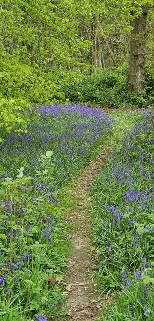
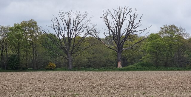
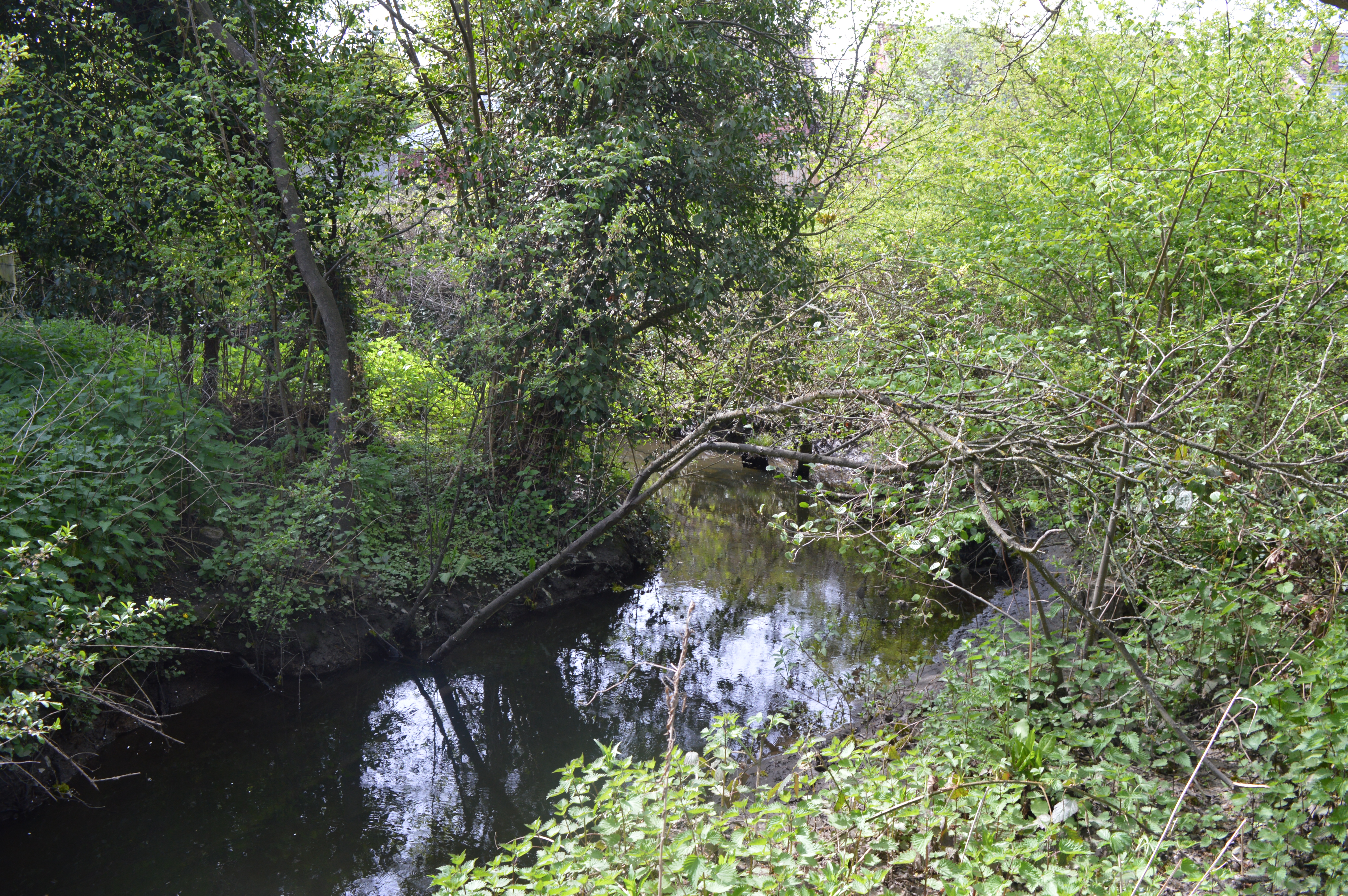
The wood is primarily composed of ancient woodland, displaying a diverse range of flora and fauna. Its dense canopy of tall trees, including oak, beech, and birch, provides a serene and tranquil atmosphere. Bluebells and wild garlic carpet the forest floor during the spring, creating a stunning display of vibrant colors.

Clingoe Hill Wood is home to a rich array of wildlife. Birdwatchers can spot various species, including woodpeckers, owls, and thrushes. Deer and other mammals also roam the wood, adding to the natural charm of the area.

Visitors can explore the woodland through a network of well-maintained footpaths, allowing them to fully immerse themselves in the beauty of the surroundings. There are picnic areas and benches scattered throughout the wood, providing ideal spots for nature enthusiasts to relax and enjoy a picnic amidst the scenic backdrop.

Clingoe Hill Wood also holds historical significance as it was once part of a medieval deer park. The remnants of ancient earthworks and ditches can still be seen today, reminding visitors of the area's past.

Overall, Clingoe Hill Wood offers a peaceful retreat from the hustle and bustle of everyday life, providing a unique opportunity to connect with nature and explore the beauty of the Essex countryside.

If you have any feedback on the listing, please let us know in the comments section below.

Clingoe Hill Wood Images

Images are sourced within 2km of 51.881686/0.94459326 or Grid Reference TM0224. Thanks to Geograph Open Source API. All images are credited.

Churn Wood, Essex A small track heading south through bluebells in Churn Wood.
Churn Wood, Essex
A small track heading south through bluebells in Churn Wood.
Crockleford Hill, Essex Looking across ploughed farmland towards a small copse near Crockleford Hill.
Crockleford Hill, Essex
Looking across ploughed farmland towards a small copse near Crockleford Hill.
Lots of vans, Colchester
Joining the main line from the Colchester Town chord
TS Colne Light Sea Cadets Training Ship has been moored at the Hythe Quay for many years. Commercial operations at the dock have now effectively ceased
TS Colne Light
Sea Cadets Training Ship has been moored at the Hythe Quay for many years. Commercial operations at the dock have now effectively ceased
Wivenhoe Park (University of Essex Buildings) The central block in the photo carries (I believe) the transmitting aerials for local station SGR Colchester. The block in the foreground carries transmitting aerials for a low power TV relay covering parts of Colchester (out of shot).
Wivenhoe Park (University of Essex Buildings)
The central block in the photo carries (I believe) the transmitting aerials for local station SGR Colchester. The block in the foreground carries transmitting aerials for a low power TV relay covering parts of Colchester (out of shot).
Hythe in 1975 This is a picture of Hythe Colchester taken in 1975 when it was still operating as an active dock. The grain was being loaded at Huslers Grain and Silage Company.
Hythe in 1975
This is a picture of Hythe Colchester taken in 1975 when it was still operating as an active dock. The grain was being loaded at Huslers Grain and Silage Company.
Coldock 1975 This is a picture of the Coldock (The Colchester Dock Transport Company) grain silo and cranes. The picture was taken in 1975 as part of a CSE project. The picture was taken looking downstream. You can see the view thirty-two years on at <a href="https://www.geograph.org.uk/photo/445163">TM0223 : Coldock Revisited</a>.
Coldock 1975
This is a picture of the Coldock (The Colchester Dock Transport Company) grain silo and cranes. The picture was taken in 1975 as part of a CSE project. The picture was taken looking downstream. You can see the view thirty-two years on at TM0223 : Coldock Revisited.
Cannock Mill, Old Heath There has been a mill on this site in Old Heath Colchester since the 14th century. The current mill is a nineteenth century structure,  now a tropical fish and aquatics shop. A fuller history may be found at <span class="nowrap"><a title="http://www.british-history.ac.uk/report.asp?compid=21998" rel="nofollow ugc noopener" href="http://www.british-history.ac.uk/report.asp?compid=21998">Link</a><img style="margin-left:2px;" alt="External link" title="External link - shift click to open in new window" src="https://s1.geograph.org.uk/img/external.png" width="10" height="10"/></span>
Cannock Mill, Old Heath
There has been a mill on this site in Old Heath Colchester since the 14th century. The current mill is a nineteenth century structure, now a tropical fish and aquatics shop. A fuller history may be found at LinkExternal link
Tin Tabernacle in Old Heath This corrugated iron chapel in Old Heath Colchester is a Congregational Church dating from 1869
Tin Tabernacle in Old Heath
This corrugated iron chapel in Old Heath Colchester is a Congregational Church dating from 1869
Sir Charles Lucas Arts College Comprehensive School named after the leader of the Royalist Army during the siege of Colchester in the English Civil War.
Sir Charles Lucas Arts College
Comprehensive School named after the leader of the Royalist Army during the siege of Colchester in the English Civil War.
Wivenhoe Fire Station in Colchester Road opposite Vine Drive
Wivenhoe Fire Station
in Colchester Road opposite Vine Drive
Cottages In Clacton Road, Elmstead there are these faintly Dutch style cottages and two other identical buildings within 500 metres in either direction. They may well have been cottages for the workers on the Wivenhoe Park, <a href="https://www.geograph.org.uk/gridref/TM0224">TM0224</a> estate. (That is the stately home painted by John Constable not the ugly tower blocks of the university which now occupy the site.)
Cottages
In Clacton Road, Elmstead there are these faintly Dutch style cottages and two other identical buildings within 500 metres in either direction. They may well have been cottages for the workers on the Wivenhoe Park, TM0224 estate. (That is the stately home painted by John Constable not the ugly tower blocks of the university which now occupy the site.)
St Johns Ambulance Station This is the St Johns Ambulance Station and Garage in Greensted Rd Colchester
St Johns Ambulance Station
This is the St Johns Ambulance Station and Garage in Greensted Rd Colchester
St. Leonard's church, Hythe, Essex Hythe is no longer a village as Colchester has swallowed it up. It still has a few interesting old buildings, which includes this 14th century church.
St. Leonard's church, Hythe, Essex
Hythe is no longer a village as Colchester has swallowed it up. It still has a few interesting old buildings, which includes this 14th century church.
St. Andrew's church, Greenstead, Essex About fifty years ago, Greenstead still had a village feel about it, but now it has been swallowed up by the ever growing town of Colchester. The church is Norman with a 16th century tower and a 19th century south aisle. The Norman builders re-used Roman brick, which must have been in abundance in Colchester.
St. Andrew's church, Greenstead, Essex
About fifty years ago, Greenstead still had a village feel about it, but now it has been swallowed up by the ever growing town of Colchester. The church is Norman with a 16th century tower and a 19th century south aisle. The Norman builders re-used Roman brick, which must have been in abundance in Colchester.
Wivenhoe House Conference Centre This is Wivenhoe House conference centre; part of Essex University. The house was built in 1758 and remodelled in 1816 it was used by the military including the SAS during WW2 and became part of Essex University in 1964. For more history and current info see <span class="nowrap"><a title="http://www.wivenhoehousehotel.co.uk/" rel="nofollow ugc noopener" href="http://www.wivenhoehousehotel.co.uk/">Link</a><img style="margin-left:2px;" alt="External link" title="External link - shift click to open in new window" src="https://s1.geograph.org.uk/img/external.png" width="10" height="10"/></span>
Wivenhoe House Conference Centre
This is Wivenhoe House conference centre; part of Essex University. The house was built in 1758 and remodelled in 1816 it was used by the military including the SAS during WW2 and became part of Essex University in 1964. For more history and current info see LinkExternal link
'The Beehive' inn, on Bromley Road
Show me another place!

Clingoe Hill Wood is located at Grid Ref: TM0224 (Lat: 51.881686, Lng: 0.94459326)

Administrative County: Essex

District: Colchester

Police Authority: Essex

What 3 Words

///pages.inner.plenty. Near Rowhedge, Essex

Nearby Locations

Clingoe Hill Wood

Related Wikis

Salary Brook Local Nature Reserve

Salary Brook Local Nature Reserve is a 17.1 hectare Local Nature Reserve covering a stretch of Salary Brook and its banks on the south-east outskirts of...

UK Data Archive

The UK Data Archive is a national centre of expertise in data archiving in the United Kingdom. It houses the largest collection of social sciences and...

University of Essex

The University of Essex is a public research university in Essex, England. Established by royal charter in 1965, it is one of the original plate glass...

Wivenhoe House

Wivenhoe House is a grade II-listed house located in Colchester, Essex. It is in use as a 4-star hotel. == History == Wivenhoe House's history began in...

Nearby Amenities

Located within 500m of 51.881686,0.94459326
Barrier: lift_gate
Foot: yes
Lat/Long: 51.8786462/0.9440989
Power: tower
Ref: PNB 23
Lat/Long: 51.8859231/0.9421526
Power: tower
Ref: PNB 24
Lat/Long: 51.8844135/0.9390807
Bus Stop
Subway
Bus: yes
Naptan AtcoCode: 150032002004
Naptan Bearing: NW
Naptan CommonName: Subway
Naptan Crossing: Valley Road
Naptan Indicator: NW-bound
Naptan Landmark: Subway
Naptan NaptanCode: esxgjgaj
Naptan PlusbusZoneRef: CLCHSTR
Naptan Street: Boundary Road
Naptan Verified: no
Public Transport: platform
Source: naptan_import
Wheelchair: yes
Lat/Long: 51.8778503/0.9414143
Bus Stop
Subway
Bus: yes
Naptan AtcoCode: 150032002005
Naptan Bearing: SE
Naptan BusStopType: CUS
Naptan CommonName: Subway
Naptan Crossing: Valley Road
Naptan Indicator: SE-bound
Naptan Landmark: Subway
Naptan NaptanCode: esxgjgam
Naptan PlusbusZoneRef: CLCHSTR
Naptan Street: Boundary Road
Naptan Verified: no
Public Transport: platform
Source: naptan_import
Wheelchair: yes
Lat/Long: 51.8778369/0.9416088
University
Layby: yes
Naptan AtcoCode: 150033031003
Naptan Bearing: W
Naptan BusStopType: CUS
Naptan CommonName: University
Naptan Crossing: West Lodge
Naptan Indicator: W-bound
Naptan Landmark: University
Naptan NaptanCode: esxamjma
Naptan PlusbusZoneRef: CLCHSTR
Naptan Street: St. Andrew's Avenue
Naptan Verified: no
Public Transport: platform
Source: naptan_import
Lat/Long: 51.8809333/0.9443625
Traffic Signals
Lat/Long: 51.8812684/0.951156
Standing Stone
Artist Name: John Maine
Artwork Type: sculpture
Tourism: artwork
Wheelchair: limited
Lat/Long: 51.8786814/0.9478484
Bicycle Parking
Capacity: 96
Lat/Long: 51.8776899/0.9449965
Artwork Type: sculpture
Tourism: artwork
Wheelchair: yes
Lat/Long: 51.8782549/0.9440535
Taxi
Check Date: 2024-02-13
Lat/Long: 51.8786767/0.9442456
Crossing
Crossing: uncontrolled
Lat/Long: 51.8780528/0.941373
Traffic Signals
Lat/Long: 51.8815746/0.9396775
Knowledge Gateway
Place: locality
Lat/Long: 51.8803852/0.9419815
Entrance: yes
Lat/Long: 51.8772479/0.9448439
Entrance: yes
Lat/Long: 51.8773039/0.944724
Power: pole
Lat/Long: 51.8855792/0.941796
Power: pole
Lat/Long: 51.8859882/0.9426246
Power: pole
Lat/Long: 51.8851885/0.9409886
Power: pole
Lat/Long: 51.8839749/0.9385129
Power: pole
Lat/Long: 51.8845892/0.9397629
Salary Brook
Description: Local Nature Reserve
Tourism: information
Lat/Long: 51.8849137/0.9399644
Barrier: kissing_gate
Lat/Long: 51.878128/0.9408598
Crossing
Crossing: marked
Crossing Ref: zebra
Lat/Long: 51.8795454/0.9401277
Crossing
Crossing: marked
Crossing Ref: zebra
Lat/Long: 51.8794454/0.9406806
Crossing
Bicycle: yes
Crossing: traffic_signals
Crossing Ref: toucan
Lat/Long: 51.8813709/0.9400321
Crossing
Bicycle: yes
Crossing: traffic_signals
Crossing Ref: toucan
Lat/Long: 51.8814997/0.9400786
Crossing
Crossing: marked
Traffic Calming: table
Lat/Long: 51.8801548/0.9420902
Barrier: yes
Lat/Long: 51.8803509/0.9432858
Ngineered ltd
Addr City: Colchester
Addr Housename: Unit 1 Red, Knowledge Gateway
Addr Postcode: CO4 3ZL
Addr Street: Nesfield Road
Ele: 1
Office: company
Phone: +44 800 088 5823
Website: http://ngineered.co.uk/
Lat/Long: 51.8806571/0.9427076
Traffic Signals
Lat/Long: 51.8813651/0.940066
Crossing
Bicycle: yes
Crossing: traffic_signals
Crossing Ref: toucan
Lat/Long: 51.8811571/0.9401203
Crossing
Crossing: marked
Crossing Ref: zebra
Lat/Long: 51.8798484/0.941018
Crossing
Crossing: marked
Crossing Ref: zebra
Lat/Long: 51.8800161/0.9403575
Traffic Signals
Lat/Long: 51.8813318/0.9397139
Fountain
Drinking Water: no
Lat/Long: 51.877747/0.9480702
Bicycle Parking
Access: yes
Bicycle Parking: stands
Lat/Long: 51.8779798/0.941897
Generator Location: roof
Generator Method: photovoltaic
Generator Output Electricity: yes
Generator Source: solar
Generator Type: solar_photovoltaic_panel
Power: generator
Lat/Long: 51.885267/0.9402132
Crossing
Lat/Long: 51.8801761/0.9453467
Motorcycle Parking
Lat/Long: 51.8786741/0.9439375
Parking
Lat/Long: 51.8798704/0.9429428
Bicycle Parking
Lat/Long: 51.8781985/0.9408512
Parking
Overflow Car Park
Lat/Long: 51.8800438/0.939711
Smoking Area
Lat/Long: 51.8776418/0.9450787
Bicycle Parking
Lat/Long: 51.8789945/0.9425775
Entrance: yes
Lat/Long: 51.8781687/0.9420275
Entrance: yes
Lat/Long: 51.8784903/0.9425478
Parking
Contractor Car Park
Parking: surface
Surface: asphalt
Lat/Long: 51.88021/0.9388211
Crossing
Crossing: marked
Crossing Markings: yes
Lat/Long: 51.8801385/0.9421819
The Copse
Tourism: hostel
Lat/Long: 51.8787882/0.9400596
Colour: yellow
Marker: post
Material: plastic
Utility: gas
Lat/Long: 51.8813526/0.9508001
Colour: yellow
Marker: post
Material: concrete
Utility: gas
Lat/Long: 51.8812181/0.9510041
Crossing
Crossing: unmarked
Crossing Markings: no
Lat/Long: 51.8805922/0.9422873
Crossing
Lat/Long: 51.8801704/0.9421628
Defibrillator
Access: yes
Defibrillator Location: on outside wall of building near road end
Emergency: defibrillator
Indoor: no
Ref GB The Circuit: F65C1327-64EA-4E33-A5E2-AE83009269B7
Lat/Long: 51.8790443/0.9393626
The data included in this document is from www.openstreetmap.org. The data is made available under ODbL.

Have you been to Clingoe Hill Wood?

Leave your review of Clingoe Hill Wood below (or comments, questions and feedback).