Hubbard's Grove

Wood, Forest in Suffolk Babergh

England

Hubbard's Grove

The ford at Kersey The River Brett crosses the main street of the village.
The ford at Kersey Credit: Jonathan Thacker

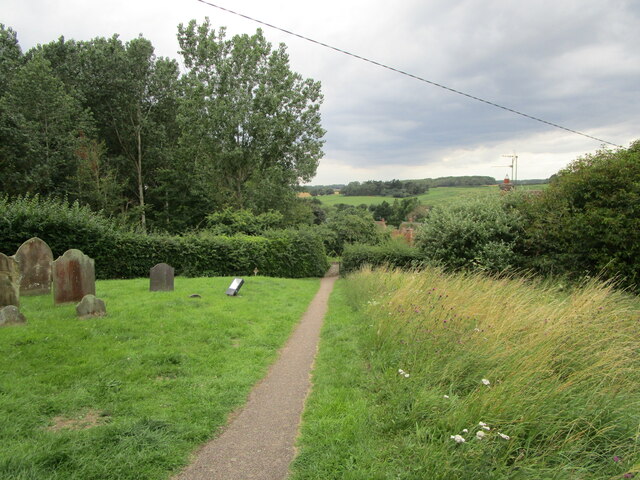
Hubbard's Grove is a picturesque woodland located in Suffolk, England. Situated near the village of Hubbard's Cross, this serene forest is renowned for its natural beauty and abundant wildlife. Spanning over 100 acres, the grove is a popular destination for nature enthusiasts, hikers, and photographers.

The woodland is characterized by its dense canopy of towering trees, mainly consisting of oak, beech, and birch. These ancient trees create a mesmerizing sight, especially during autumn when their leaves turn vibrant shades of red, orange, and gold. The forest floor is carpeted with a diverse range of flora, including bluebells, wild garlic, and foxgloves, adding to the enchanting atmosphere.

Hubbard's Grove is home to a variety of wildlife, making it a haven for animal lovers. Visitors may catch glimpses of deer, foxes, badgers, and squirrels, as well as a multitude of bird species such as woodpeckers, owls, and jays. The forest's tranquil ambiance and secluded trails provide an ideal habitat for these creatures.

For outdoor enthusiasts, the grove offers numerous walking trails and paths, allowing visitors to explore its natural wonders at their own pace. There are also designated picnic areas and benches where visitors can relax and immerse themselves in the peaceful surroundings. Additionally, there are several information boards scattered throughout the woodland, providing educational insights into the local flora and fauna.

Hubbard's Grove is a true gem of Suffolk, offering a serene escape from the bustling city life. Whether it's a leisurely stroll, a wildlife-spotting adventure, or a family picnic, this woodland sanctuary provides an unforgettable experience for all who visit.

If you have any feedback on the listing, please let us know in the comments section below.

Hubbard's Grove Images

Images are sourced within 2km of 52.068013/0.90264471 or Grid Reference TL9945. Thanks to Geograph Open Source API. All images are credited.

The ford at Kersey The River Brett crosses the main street of the village.
The ford at Kersey
The River Brett crosses the main street of the village.
The churchyard at Kersey This churchyard has a numerous collection of iron grave markers of the early twentieth century. There were two local manufacturers of such markers - Hunt at the Atlas Works, Earls Colne, Essex and L Ward at Long Melford <span class="nowrap"><a title="https://industrial-archaeology.org/wp-content/uploads/2016/04/AIA-Bulletin-15-3-1988.pdf" rel="nofollow ugc noopener" href="https://industrial-archaeology.org/wp-content/uploads/2016/04/AIA-Bulletin-15-3-1988.pdf">Link</a><img style="margin-left:2px;" alt="External link" title="External link - shift click to open in new window" src="https://s1.geograph.org.uk/img/external.png" width="10" height="10"/></span>
The churchyard at Kersey
This churchyard has a numerous collection of iron grave markers of the early twentieth century. There were two local manufacturers of such markers - Hunt at the Atlas Works, Earls Colne, Essex and L Ward at Long Melford LinkExternal link
The Bell Inn, Kersey Dates from the fifteenth and sixteenth centuries <span class="nowrap"><a title="https://historicengland.org.uk/listing/the-list/list-entry/1285465?section=official-listing" rel="nofollow ugc noopener" href="https://historicengland.org.uk/listing/the-list/list-entry/1285465?section=official-listing">Link</a><img style="margin-left:2px;" alt="External link" title="External link - shift click to open in new window" src="https://s1.geograph.org.uk/img/external.png" width="10" height="10"/></span>
The Bell Inn, Kersey
Dates from the fifteenth and sixteenth centuries LinkExternal link
Carlton House, Kersey Datea from the sixteenth and seventeenth centuries <span class="nowrap"><a title="https://historicengland.org.uk/listing/the-list/list-entry/1037248?section=official-listing" rel="nofollow ugc noopener" href="https://historicengland.org.uk/listing/the-list/list-entry/1037248?section=official-listing">Link</a><img style="margin-left:2px;" alt="External link" title="External link - shift click to open in new window" src="https://s1.geograph.org.uk/img/external.png" width="10" height="10"/></span>
Carlton House, Kersey
Datea from the sixteenth and seventeenth centuries LinkExternal link
The River Brett at Kersey
River View, Kersey Of seventeenth century origin <span class="nowrap"><a title="https://historicengland.org.uk/listing/the-list/list-entry/1037234?section=official-listing" rel="nofollow ugc noopener" href="https://historicengland.org.uk/listing/the-list/list-entry/1037234?section=official-listing">Link</a><img style="margin-left:2px;" alt="External link" title="External link - shift click to open in new window" src="https://s1.geograph.org.uk/img/external.png" width="10" height="10"/></span>
River View, Kersey
Of seventeenth century origin LinkExternal link
Olde Drift House. Kersey Much altered house dating from the sixteenth century <span class="nowrap"><a title="https://historicengland.org.uk/listing/the-list/list-entry/1037235?section=official-listing" rel="nofollow ugc noopener" href="https://historicengland.org.uk/listing/the-list/list-entry/1037235?section=official-listing">Link</a><img style="margin-left:2px;" alt="External link" title="External link - shift click to open in new window" src="https://s1.geograph.org.uk/img/external.png" width="10" height="10"/></span>
Olde Drift House. Kersey
Much altered house dating from the sixteenth century LinkExternal link
7 Church Hill, Kersey Seventeenth century cottage <span class="nowrap"><a title="https://historicengland.org.uk/listing/the-list/list-entry/1037274?section=official-listing" rel="nofollow ugc noopener" href="https://historicengland.org.uk/listing/the-list/list-entry/1037274?section=official-listing">Link</a><img style="margin-left:2px;" alt="External link" title="External link - shift click to open in new window" src="https://s1.geograph.org.uk/img/external.png" width="10" height="10"/></span>
7 Church Hill, Kersey
Seventeenth century cottage LinkExternal link
Path and steps to the church, Kersey
Church Hill, Kersey
Church Hill, Kersey
St. Mary's church, Kersey The church largely dates from the fourteenth and fifteenth centuries <span class="nowrap"><a title="https://historicengland.org.uk/listing/the-list/list-entry/1351459?section=official-listing" rel="nofollow ugc noopener" href="https://historicengland.org.uk/listing/the-list/list-entry/1351459?section=official-listing">Link</a><img style="margin-left:2px;" alt="External link" title="External link - shift click to open in new window" src="https://s1.geograph.org.uk/img/external.png" width="10" height="10"/></span>
St. Mary's church, Kersey
The church largely dates from the fourteenth and fifteenth centuries LinkExternal link
Church Hill, Kersey
Church Hill, Kersey
Path through the churchyard, Kersey
The Little Manor, Kersey The oldest parts date to the fourteenth century <span class="nowrap"><a title="https://historicengland.org.uk/listing/the-list/list-entry/1351461?section=official-listing" rel="nofollow ugc noopener" href="https://historicengland.org.uk/listing/the-list/list-entry/1351461?section=official-listing">Link</a><img style="margin-left:2px;" alt="External link" title="External link - shift click to open in new window" src="https://s1.geograph.org.uk/img/external.png" width="10" height="10"/></span>
The Little Manor, Kersey
The oldest parts date to the fourteenth century LinkExternal link
Ley's House, Kersey A much altered timber framed house <span class="nowrap"><a title="https://historicengland.org.uk/listing/the-list/list-entry/1180354?section=official-listing" rel="nofollow ugc noopener" href="https://historicengland.org.uk/listing/the-list/list-entry/1180354?section=official-listing">Link</a><img style="margin-left:2px;" alt="External link" title="External link - shift click to open in new window" src="https://s1.geograph.org.uk/img/external.png" width="10" height="10"/></span>
Ley's House, Kersey
A much altered timber framed house LinkExternal link
The ford at Kersey With St Mary’s church beyond, at the summit of Church Hill.
The ford at Kersey
With St Mary’s church beyond, at the summit of Church Hill.
Church Hill The village of Kersey from near the summit.
Church Hill
The village of Kersey from near the summit.
Show me another place!

Hubbard's Grove is located at Grid Ref: TL9945 (Lat: 52.068013, Lng: 0.90264471)

Administrative County: Suffolk

District: Babergh

Police Authority: Suffolk

What 3 Words

///consonant.retaliate.active. Near Hadleigh, Suffolk

Related Wikis

Kersey Priory

Kersey Priory was a priory in Kersey, Suffolk, England. It was founded before 1218 as a hospital dedicated St Mary the Blessed Virgin and St Anthony under...

Lindsey, Suffolk

Lindsey is a small village and a civil parish, located in mid-to-south Suffolk, under the purview of Babergh District Council. == Layout == The parish...

Semer, Suffolk

Semer is a small village and civil parish in Suffolk, England. Located adjacent to a bridge over the River Brett on the B1115 between Hadleigh and Stowmarket...

Kersey, Suffolk

Kersey is a village and civil parish in the Babergh district in Suffolk, in the east of England. The main street has a ford across a stream. Its principal...

Nearby Amenities

Located within 500m of 52.068013,0.90264471
Drakestone Green
Place: hamlet
Wikidata: Q1391138
Lat/Long: 52.0706446/0.9078509
The data included in this document is from www.openstreetmap.org. The data is made available under ODbL.

Have you been to Hubbard's Grove?

Leave your review of Hubbard's Grove below (or comments, questions and feedback).