Auchencairn

Settlement in Kirkcudbrightshire

Scotland

Auchencairn

Track to Bluehill Leaving Blackford Bridge.
Track to Bluehill Credit: Jon Alexander

Auchencairn is a small village located in Kirkcudbrightshire, Scotland. Situated on the east coast of the Solway Firth, the village is known for its picturesque views of the surrounding countryside and the nearby Auchencairn Bay. The village has a population of around 400 residents and is surrounded by rolling hills and farmland.

Auchencairn is a popular destination for outdoor enthusiasts, with a range of activities available such as hiking, cycling, and birdwatching. The village is also close to several sandy beaches, making it an ideal spot for beachgoers and water sports enthusiasts.

The village has a strong sense of community, with a range of amenities including a primary school, church, village hall, and a few local shops and restaurants. Auchencairn also hosts various events throughout the year, such as a summer fete and a Christmas market, which bring residents and visitors together.

Overall, Auchencairn is a charming and peaceful village that offers a relaxing retreat for those looking to escape the hustle and bustle of city life.

If you have any feedback on the listing, please let us know in the comments section below.

Auchencairn Images

Images are sourced within 2km of 54.843124/-3.872655 or Grid Reference NX7951. Thanks to Geograph Open Source API. All images are credited.

Track to Bluehill Leaving Blackford Bridge.
Track to Bluehill
Leaving Blackford Bridge.
Blackford Bridge The remaining visible parapet of Blackford Bridge crossing Blackford Burn on the old A711, left when it was straightened.
Blackford Bridge
The remaining visible parapet of Blackford Bridge crossing Blackford Burn on the old A711, left when it was straightened.
Minor road near Farhills
Farhills steading The local joke has it that Farhills is so named because it isn't very far and doesn't have any hills. However, as this photo shows, it has a reasonable view of Bengairn; and, looking the other way, the English hills are visible across the water.
Farhills steading
The local joke has it that Farhills is so named because it isn't very far and doesn't have any hills. However, as this photo shows, it has a reasonable view of Bengairn; and, looking the other way, the English hills are visible across the water.
Whitewashed Shed A whitewashed outbuilding on Farhills Farm.
Whitewashed Shed
A whitewashed outbuilding on Farhills Farm.
Roadway & Steading, Farhills, Auchencairn.
Auchencairn Parish Church
Church Road, Auchencairn
Farmland at Auchencairn With view over to Torr Point.
Farmland at Auchencairn
With view over to Torr Point.
Farmland, Farhills
Farmland, Farhills
Bluebells beside a wall, near Farhills
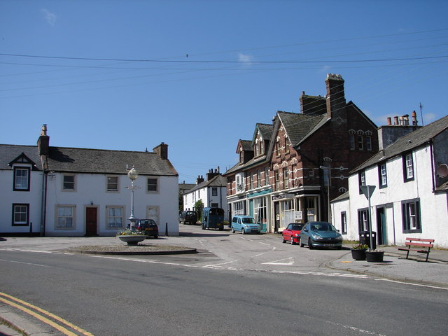
In the centre of Auchencairn The "Jubilee Lamp" was erected by public subscription in 1897 to mark the sixtieth year of Queen Victoria's long reign.
In the centre of Auchencairn
The "Jubilee Lamp" was erected by public subscription in 1897 to mark the sixtieth year of Queen Victoria's long reign.
Looking north-east from the viewpoint at Hazlefield The house on the right is Drungans. The A711 can just be seen curving round to the left.
Looking north-east from the viewpoint at Hazlefield
The house on the right is Drungans. The A711 can just be seen curving round to the left.
Junction of A711 and Shore Road, Auchencairn The bridge on the left carries the A711 across the Auchencairn Burn, which enters Auchencairn Bay less than half a mile from this point. This is the section of the A711 from Dalbeattie to Kirkcudbright.
The War Memorial on the right is a simple stone Maltese Cross located at the corner of the A711 and Shore Road, a 'no-through road' branching off to the right.
Junction of A711 and Shore Road, Auchencairn
The bridge on the left carries the A711 across the Auchencairn Burn, which enters Auchencairn Bay less than half a mile from this point. This is the section of the A711 from Dalbeattie to Kirkcudbright. The War Memorial on the right is a simple stone Maltese Cross located at the corner of the A711 and Shore Road, a 'no-through road' branching off to the right.
Rascarrel Lane The hill ahead is Bengairn.
Rascarrel Lane
The hill ahead is Bengairn.
Show me another place!

Auchencairn is located at Grid Ref: NX7951 (Lat: 54.843124, Lng: -3.872655)

Unitary Authority: Dumfries and Galloway

Police Authority: Dumfries and Galloway

What 3 Words

///processor.direction.parent. Near Dalbeattie, Dumfries & Galloway

Nearby Locations

Auchencairn

Related Wikis

Auchencairn

Auchencairn ([ɔxən'kʰɛ:(r)n]) is a village in the historical county of Kirkcudbrightshire in the Dumfries and Galloway region of Scotland. It is located...

Orchardton Castle

Orchardton Castle overlooks the Solway Coast. Built in the 1880s, this is a Grade B listed property formerly known as Orchardton House. Built around a...

Urr Water

Urr Water or River Urr (arc. River Orr) is a river in which flows through the counties of Dumfriesshire and Kirkcudbrightshire in southwest Scotland....

Hestan Island

Hestan Island is a small coastal island at the southern foot of the River Urr estuary in the Solway Firth, in the historical county of Kirkcudbrightshire...

Nearby Amenities

Located within 500m of 54.843124,-3.872655
Auchencairn
Is In: Dumfries & Galloway, Scotland, UK
Is In Country Code: GB
Is In County: Dumfries & Galloway
Is In Historic County: Dumfriesshire
Name En: Auchencairn
Name Gd: Achadh nan Càrn
Place: village
Lat/Long: 54.8433925/-3.87245
Recycling
Lat/Long: 54.8449654/-3.8680109
Parking
Created By: Potlatch 0.10f
Lat/Long: 54.845352/-3.8672227
Pub
Old Smugglers Inn
Lat/Long: 54.8437237/-3.8718468
Post Box
Post Box Type: lamp
Royal Cypher: scottish_crown
Lat/Long: 54.8425337/-3.8722194
Bus Stop
Village
Naptan AtcoCode: 680000062333
Naptan Bearing: S
Naptan CommonName: Village
Naptan Indicator: Balcary Bay Road End
Naptan Landmark: Balcary bay
Naptan NaptanCode: 34236395
Naptan Notes: none
Naptan Street: Main Street
Naptan Verified: no
Source: naptan_import
Lat/Long: 54.8440853/-3.8706612
Bus Stop
Village
Naptan AtcoCode: 680000062444
Naptan Bearing: N
Naptan BusStopType: CUS
Naptan CommonName: Village
Naptan Indicator: opp Balcary Bay Road End
Naptan Landmark: Balcary Bay
Naptan NaptanCode: 34236396
Naptan Notes: none
Naptan Street: Main Street
Naptan Verified: no
Source: naptan_import
Lat/Long: 54.8439987/-3.871031
Bus Stop
Village
Naptan AtcoCode: 680000062501
Naptan Bearing: N
Naptan CommonName: Village
Naptan Indicator: Fountain
Naptan Landmark: Fountain
Naptan NaptanCode: 34236397
Naptan Notes: none
Naptan Street: Main Street
Naptan Verified: no
Shelter: yes
Source: naptan_import
Lat/Long: 54.8425686/-3.8722575
Bus Stop
Village
Naptan AtcoCode: 680000062502
Naptan Bearing: S
Naptan CommonName: Village
Naptan Indicator: School
Naptan Landmark: Primary School
Naptan NaptanCode: 34236423
Naptan Notes: none
Naptan Street: Main Street
Naptan Verified: no
Source: naptan_import
Lat/Long: 54.8416355/-3.8750644
Bus Stop
Village
Naptan AtcoCode: 680000062503
Naptan Bearing: N
Naptan CommonName: Village
Naptan Indicator: opp School
Naptan Landmark: Primary School
Naptan NaptanCode: 34236424
Naptan Notes: none
Naptan Street: Main Street
Naptan Verified: no
Source: naptan_import
Lat/Long: 54.8415156/-3.8752613
Bus Stop
Village
Naptan AtcoCode: 680000062504
Naptan Bearing: S
Naptan CommonName: Village
Naptan Indicator: opp Fountain
Naptan Landmark: Fountain
Naptan NaptanCode: 34236398
Naptan Notes: none
Naptan Street: Main Street
Naptan Verified: no
Source: naptan_import
Lat/Long: 54.842589/-3.8721027
Toilets
Lat/Long: 54.8429758/-3.872165
Spout
Drinking Water: yes
Drinking Water Legal: no
Natural: spring
Lat/Long: 54.8426399/-3.8729831
Tourism: picnic_site
Lat/Long: 54.8440422/-3.8717746
Cafe
Auchencairn Store
Addr City: Auchencairn
Addr Country: GB
Addr Housenumber: 7
Addr Postcode: DG7 1QU
Addr Street: Main Street
Contact Facebook: https://www.facebook.com/Auchencairn-Store-350201085665575/
Cuisine: cake;coffee_shop;ice_cream;tea
Fhrs Id: 1051881
Phone: +44 1556 640385
Lat/Long: 54.8438915/-3.8713586
Restaurant
The Dragonfly
Addr City: Auchencairn
Addr Country: GB
Addr Housenumber: 11
Addr Postcode: DG7 1QU
Addr Street: Main Street
Contact Facebook: https://www.facebook.com/The-Dragonfly-2284925428452467/
Diet Vegan: yes
Diet Vegetarian: yes
Email: relax@gallowayholisticretreats.co.uk
Fhrs Id: 1152616
Phone: +44 1556 640088
Lat/Long: 54.8435472/-3.8716481
Historic: memorial
Memorial: war_memorial
Lat/Long: 54.8443695/-3.8703758
Post Office
Auchencairn Post Office
Addr City: Castle Douglas
Addr Country: GB
Addr Housename: Heughan House
Addr Postcode: DG7 1QU
Addr Street: Main Street
Addr Village: Auchencairn
Brand: Post Office
Brand Wikidata: Q1783168
Check Date: 2022-05-27
Check Date Opening Hours: 2022-05-27
Contact Website: https://www.postoffice.co.uk/branch-finder/0134724/auchencairn
Opening Hours: Tu 13:30-14:30
Ref Pol Id: 178238
Lat/Long: 54.843888/-3.8712358
Power: pole
Lat/Long: 54.8444341/-3.8751725
Power: pole
Lat/Long: 54.8433515/-3.875523
Power: pole
Lat/Long: 54.8422909/-3.8758289
Power: pole
Lat/Long: 54.8418897/-3.8759628
Power: pole
Lat/Long: 54.8413269/-3.8761412
Power: pole
Lat/Long: 54.840911/-3.8736174
Power: pole
Lat/Long: 54.8406443/-3.871973
Power: pole
Lat/Long: 54.8402858/-3.8698401
Power: pole
Lat/Long: 54.8459999/-3.8780894
Power: pole
Lat/Long: 54.8455302/-3.8772035
Power: pole
Lat/Long: 54.8449858/-3.8761965
Power: pole
Lat/Long: 54.8435375/-3.8744034
Power: pole
Lat/Long: 54.8431913/-3.8741039
Power: pole
Lat/Long: 54.8436769/-3.8738298
Power: pole
Lat/Long: 54.8438298/-3.8736662
Power: pole
Lat/Long: 54.8441369/-3.8732541
Power: pole
Lat/Long: 54.8460739/-3.8675032
Power: pole
Lat/Long: 54.8456286/-3.8670634
Power: pole
Lat/Long: 54.8451663/-3.8666428
Power: pole
Lat/Long: 54.8450623/-3.8661966
Power: pole
Lat/Long: 54.8449424/-3.8657165
Power: pole
Lat/Long: 54.8446647/-3.8667745
Power: pole
Lat/Long: 54.8442696/-3.8698571
Power: pole
Lat/Long: 54.8443295/-3.8688947
Power: pole
Lat/Long: 54.8444005/-3.8678495
The data included in this document is from www.openstreetmap.org. The data is made available under ODbL.

Have you been to Auchencairn?

Leave your review of Auchencairn below (or comments, questions and feedback).