Birch Belt
Wood, Forest in Norfolk Breckland
England
Birch Belt

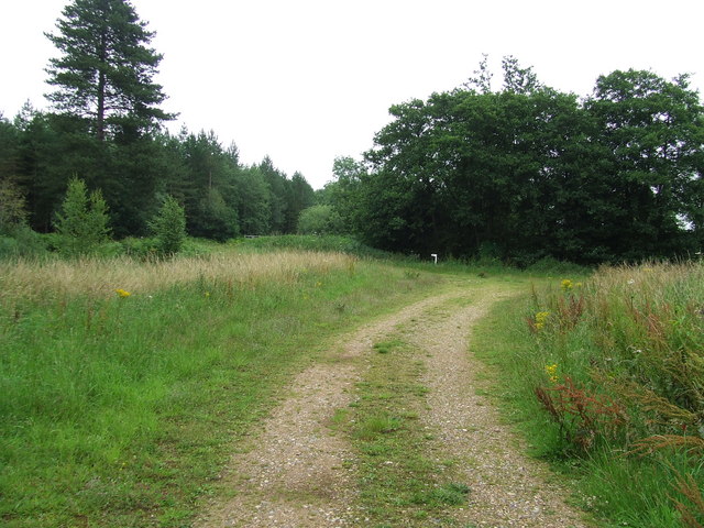
Birch Belt, Norfolk, also known as the Birch Wood or Birch Forest, is a natural area located in the county of Norfolk, England. The Birch Belt is characterized by its extensive growth of birch trees, which dominate the landscape and give the area its name.
This woodland is situated in a rural setting, encompassing an area of approximately 100 hectares. It is known for its diverse flora and fauna, offering a habitat for various species. The birch trees, with their slender trunks and distinctive white bark, create an enchanting atmosphere throughout the forest.
The Birch Belt is renowned for its scenic beauty, attracting nature enthusiasts, hikers, and photographers alike. The area is crisscrossed by numerous walking trails, allowing visitors to explore and immerse themselves in the tranquil surroundings. These paths wind through the woodland, providing glimpses of wildflowers, moss-covered rocks, and occasional wildlife sightings.
The forest is also home to a variety of bird species, including woodpeckers, owls, and warblers. Additionally, small mammals such as squirrels and rabbits can be spotted darting among the undergrowth. The Birch Belt provides an important habitat for these creatures, contributing to the local ecosystem's biodiversity.
As an area of natural beauty, the Birch Belt is protected and managed by local conservation organizations. They ensure the preservation of the woodland and its delicate balance of flora and fauna. The site is open to the public, allowing visitors to appreciate the wonders of nature while respecting the environment and its inhabitants.
If you have any feedback on the listing, please let us know in the comments section below.
Birch Belt Images
Images are sourced within 2km of 52.482112/0.89019052 or Grid Reference TL9691. Thanks to Geograph Open Source API. All images are credited.


Birch Belt is located at Grid Ref: TL9691 (Lat: 52.482112, Lng: 0.89019052)
Administrative County: Norfolk
District: Breckland
Police Authority: Norfolk
What 3 Words
///beginning.flotation.hops. Near East Harling, Norfolk
Nearby Locations
Related Wikis

Great Hockham
Great Hockham is a village in the English county of Norfolk within the civil parish of Hockham, though the distinction between village and parish may now...

Hockham
Hockham is a civil parish in the English county of Norfolk. It covers an area of 13.36 km2 (5.16 sq mi) and had a population of 620 in 252 households at...

Illington
Illington is a village and former civil parish, now in the parish of Wretham in the Breckland district, in the county of Norfolk, England. The village...

Larling
Larling is a village and former civil parish, now in the parish of Roudham and Larling, in the Breckland district, in the county of Norfolk, England. The...
Shropham Hall
Shropham Hall is an early Georgian country house in Shropham in the county of Norfolk. It was completed by 1729 for John Barker, later High Sheriff of...

Shropham
Shropham is a civil parish in the English county of Norfolk. It covers an area of 11.12 km2 (4.29 sq mi) and had a population of 351 in 155 households...

Snetterton
Snetterton is a village and civil parish in Norfolk, England. The village is about 9 miles (14 km) east-northeast of Thetford and 19 miles (31 km) southwest...

Roudham and Larling
Roudham and Larling is a civil parish in the English county of Norfolk. It includes the villages of Roudham and Larling. It covers an area of 15.20 km2...
Nearby Amenities
Located within 500m of 52.482112,0.89019052Have you been to Birch Belt?
Leave your review of Birch Belt below (or comments, questions and feedback).