Potter's Plantation

Wood, Forest in Suffolk West Suffolk

England

Potter's Plantation

Pakenham watermill Rebuilt 1814 on an ancient site <span class="nowrap"><a title="https://historicengland.org.uk/listing/the-list/list-entry/1285022" rel="nofollow ugc noopener" href="https://historicengland.org.uk/listing/the-list/list-entry/1285022">Link</a><img style="margin-left:2px;" alt="External link" title="External link - shift click to open in new window" src="https://s1.geograph.org.uk/img/external.png" width="10" height="10"/></span>
Pakenham watermill Credit: Jonathan Thacker

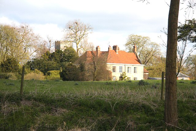
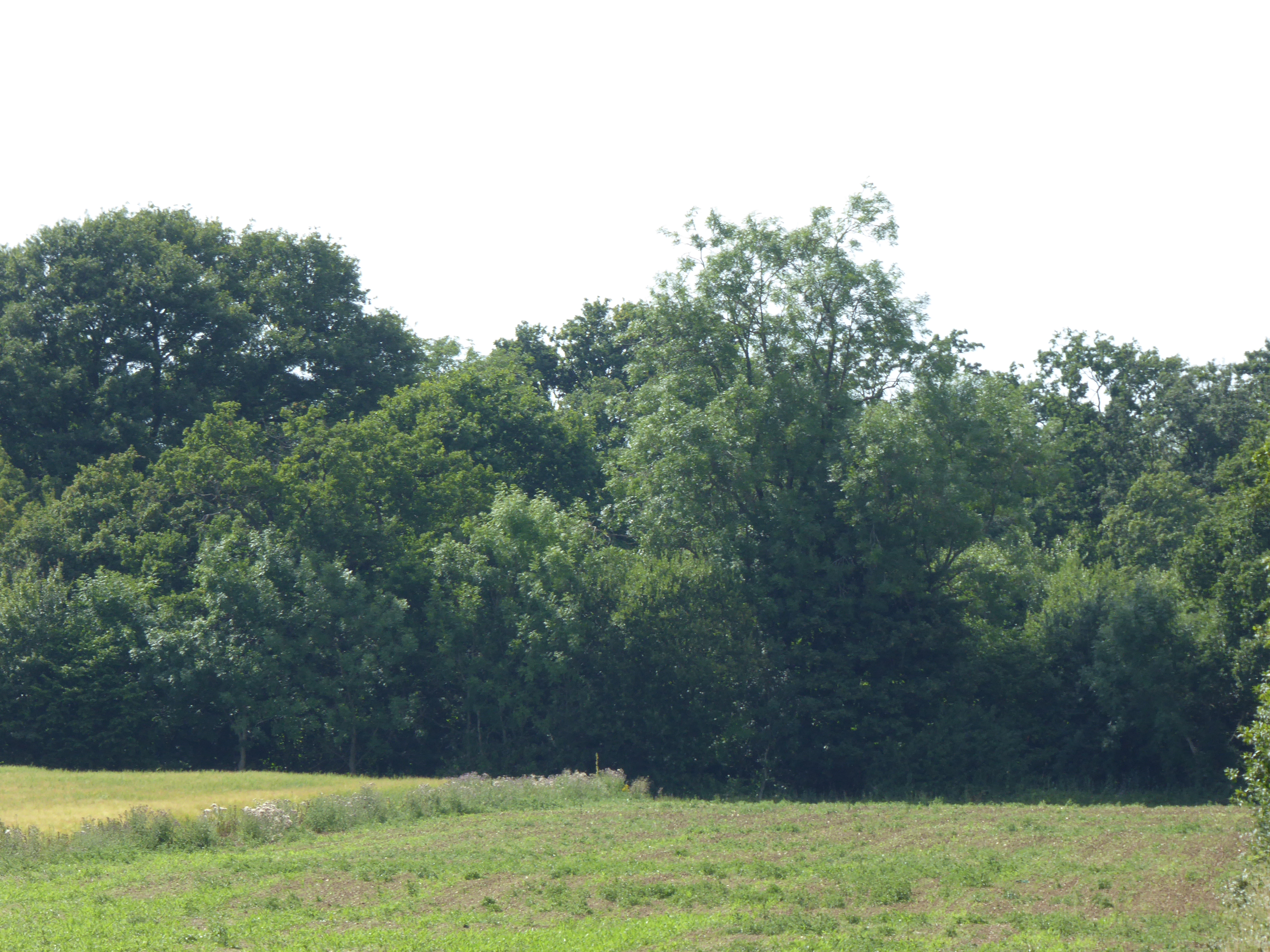
Potter's Plantation, located in Suffolk, is a captivating woodland area that offers a serene and picturesque experience for nature enthusiasts. Covering a vast expanse of land, this forested plantation boasts an impressive array of trees, creating a lush and vibrant environment. The plantation is particularly famous for its diverse collection of oak, beech, and pine trees, which dominate the landscape.

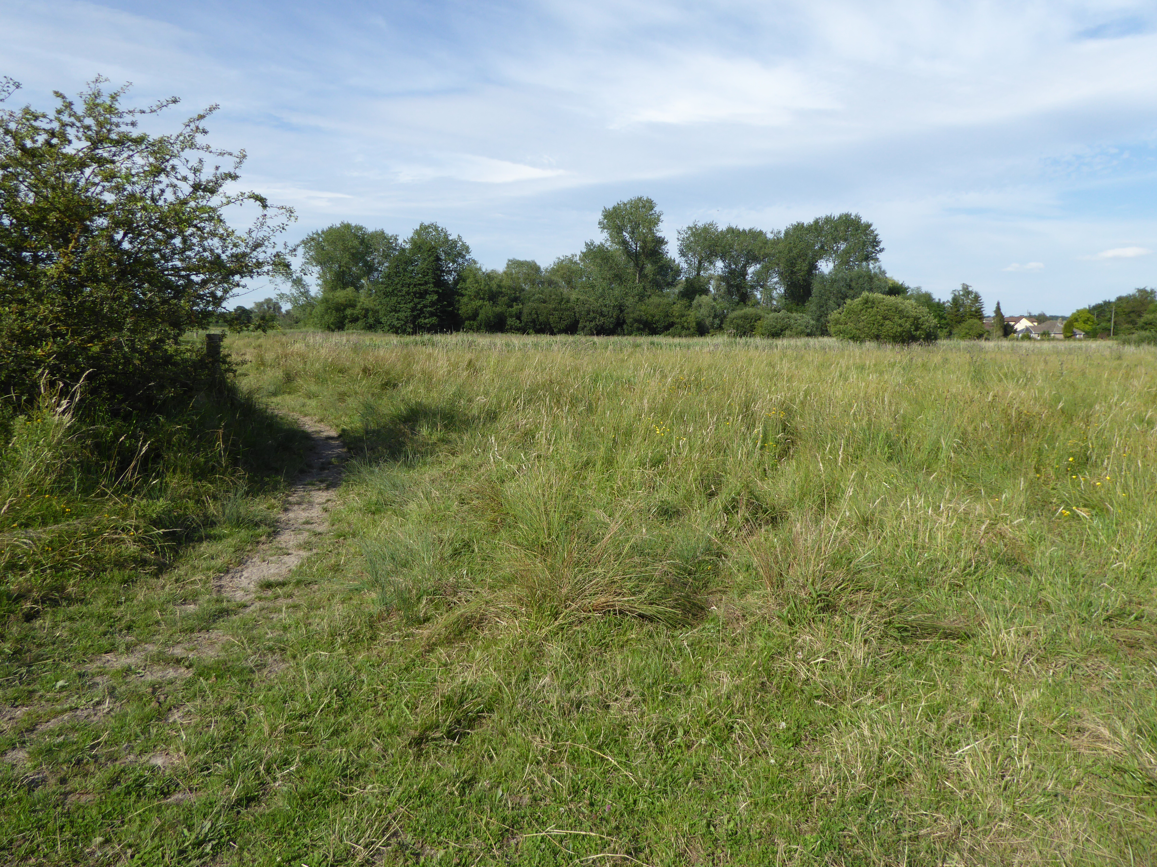
Visitors to Potter's Plantation can enjoy leisurely walks along the well-maintained trails that wind through the forest. The paths are lined with wildflowers and various species of shrubs, adding a splash of color to the surroundings. The plantation's well-preserved ecosystem provides a habitat for numerous wildlife species, including deer, rabbits, and a wide variety of birds, making it a popular destination for birdwatchers.

In addition to its natural beauty, Potter's Plantation also offers recreational activities such as picnicking and camping. Several designated picnic areas are scattered throughout the forest, providing visitors with the perfect spot to relax and enjoy a meal amidst the tranquil surroundings. For those seeking a longer stay, the plantation offers camping facilities, allowing visitors to spend the night under the stars and fully immerse themselves in the peaceful ambiance of the forest.

Potter's Plantation is not only a haven for nature lovers but also serves as an educational site. The plantation regularly hosts guided tours and workshops, providing visitors with insights into the local flora and fauna, as well as the historical significance of the area.

Overall, Potter's Plantation in Suffolk is a natural oasis that offers a unique combination of scenic beauty, recreational activities, and educational opportunities, making it a must-visit destination for anyone seeking a peaceful retreat in the heart of nature.

If you have any feedback on the listing, please let us know in the comments section below.

Potter's Plantation Images

Images are sourced within 2km of 52.303153/0.82400212 or Grid Reference TL9270. Thanks to Geograph Open Source API. All images are credited.

Pakenham watermill Rebuilt 1814 on an ancient site <span class="nowrap"><a title="https://historicengland.org.uk/listing/the-list/list-entry/1285022" rel="nofollow ugc noopener" href="https://historicengland.org.uk/listing/the-list/list-entry/1285022">Link</a><img style="margin-left:2px;" alt="External link" title="External link - shift click to open in new window" src="https://s1.geograph.org.uk/img/external.png" width="10" height="10"/></span>
Pakenham watermill
Rebuilt 1814 on an ancient site LinkExternal link
Pakenham Watermill, still grinding flour Pakenham Watermill stands on a tributary of the Black Bourn and still grinds flour. It is open to visitors at designated times. A datestone on the south gable wall reads 'C.L. 1814', for Charles Low, who rebuilt much of the mill about that time utilising earlier foundations. The mill was restored to full working order in the late 1970s. It consists of three storeys and an attic story where the lucum is located in the pantiled roof. The ground floor is tarred brick with timber-framed upper storeys, and rendered on the front of the building. Weather-boarded on the gable ends. A loading door on the first floor has a semi-circular fanlight and a loading skid below to prevent damage to sacks and wall. The waterwheel is a low breast shot waterwheel installed about 19OO. It drives three pairs of under-driven millstones.
Pakenham Watermill, still grinding flour
Pakenham Watermill stands on a tributary of the Black Bourn and still grinds flour. It is open to visitors at designated times. A datestone on the south gable wall reads 'C.L. 1814', for Charles Low, who rebuilt much of the mill about that time utilising earlier foundations. The mill was restored to full working order in the late 1970s. It consists of three storeys and an attic story where the lucum is located in the pantiled roof. The ground floor is tarred brick with timber-framed upper storeys, and rendered on the front of the building. Weather-boarded on the gable ends. A loading door on the first floor has a semi-circular fanlight and a loading skid below to prevent damage to sacks and wall. The waterwheel is a low breast shot waterwheel installed about 19OO. It drives three pairs of under-driven millstones.
Pakenham Watermill, still grinding flour Pakenham Watermill stands on a tributary of the Black Bourn and still grinds flour. It is open to visitors at designated times. A datestone on the south gable wall reads 'C.L. 1814', for Charles Low, who rebuilt much of the mill about that time utilising earlier foundations. The mill was restored to full working order in the late 1970s. It consists of three storeys and an attic story where the lucum is located in the pantiled roof. The ground floor is tarred brick with timber-framed upper storeys, and rendered on the front of the building. Weather-boarded on the gable ends. A loading door on the first floor has a semi-circular fanlight and a wooden loading skid below to prevent damage to sacks and wall. The waterwheel is a low breast shot waterwheel installed about 19OO. It drives three pairs of under-driven millstones. <a title="https://www.geograph.org.uk/photo/6980654" href="https://www.geograph.org.uk/photo/6980654">Link</a>
Pakenham Watermill, still grinding flour
Pakenham Watermill stands on a tributary of the Black Bourn and still grinds flour. It is open to visitors at designated times. A datestone on the south gable wall reads 'C.L. 1814', for Charles Low, who rebuilt much of the mill about that time utilising earlier foundations. The mill was restored to full working order in the late 1970s. It consists of three storeys and an attic story where the lucum is located in the pantiled roof. The ground floor is tarred brick with timber-framed upper storeys, and rendered on the front of the building. Weather-boarded on the gable ends. A loading door on the first floor has a semi-circular fanlight and a wooden loading skid below to prevent damage to sacks and wall. The waterwheel is a low breast shot waterwheel installed about 19OO. It drives three pairs of under-driven millstones. Link
The tailrace after passing beneath the road The mill pond and headrace are behind the mill and the water comes from Pakenham Fen and beyond. After leaving the mill through the tailrace the water travels about 300 yards before joining the Black Bourn before converging with the Little Ouse south of Thetford.
Pakenham Watermill stands on the Black Bourn and still grinds flour. It is open to visitors at designated times. A datestone on the south gable wall reads 'C.L. 1814', for Charles Low, who rebuilt much of the mill about that time utilising earlier foundations. The mill was restored to full working order in the late 1970s. It consists of three storeys and an attic story where the lucum is located in the pantiled roof. The ground floor is tarred brick with timber-framed upper storeys, and rendered on the front of the building. Weather-boarded on the gable ends. A loading door on the first floor has a semi-circular fanlight and a wooden loading skid below to prevent damage to sacks and wall. The waterwheel is a low breast shot waterwheel installed about 19OO. It drives three pairs of under-driven millstones. <a title="https://www.geograph.org.uk/photo/6980654" href="https://www.geograph.org.uk/photo/6980654">Link</a>
The tailrace after passing beneath the road
The mill pond and headrace are behind the mill and the water comes from Pakenham Fen and beyond. After leaving the mill through the tailrace the water travels about 300 yards before joining the Black Bourn before converging with the Little Ouse south of Thetford. Pakenham Watermill stands on the Black Bourn and still grinds flour. It is open to visitors at designated times. A datestone on the south gable wall reads 'C.L. 1814', for Charles Low, who rebuilt much of the mill about that time utilising earlier foundations. The mill was restored to full working order in the late 1970s. It consists of three storeys and an attic story where the lucum is located in the pantiled roof. The ground floor is tarred brick with timber-framed upper storeys, and rendered on the front of the building. Weather-boarded on the gable ends. A loading door on the first floor has a semi-circular fanlight and a wooden loading skid below to prevent damage to sacks and wall. The waterwheel is a low breast shot waterwheel installed about 19OO. It drives three pairs of under-driven millstones. Link
Pakenham Watermill, still grinding flour Pakenham Watermill stands on a tributary of the Black Bourn and still grinds flour. It is open to visitors at designated times. A datestone on the south gable wall reads 'C.L. 1814', for Charles Low, who rebuilt much of the mill about that time utilising earlier foundations. The mill was restored to full working order in the late 1970s. It consists of three storeys and an attic story where the lucum is located in the pantiled roof. The ground floor is tarred brick with timber-framed upper storeys, and rendered on the front of the building. Weather-boarded on the gable ends. A loading door on the first floor has a semi-circular fanlight and a wooden loading skid below to prevent damage to sacks and wall. The waterwheel is a low breast shot waterwheel installed about 19OO. It drives three pairs of under-driven millstones. <a title="https://www.geograph.org.uk/photo/6980654" href="https://www.geograph.org.uk/photo/6980654">Link</a>
Pakenham Watermill, still grinding flour
Pakenham Watermill stands on a tributary of the Black Bourn and still grinds flour. It is open to visitors at designated times. A datestone on the south gable wall reads 'C.L. 1814', for Charles Low, who rebuilt much of the mill about that time utilising earlier foundations. The mill was restored to full working order in the late 1970s. It consists of three storeys and an attic story where the lucum is located in the pantiled roof. The ground floor is tarred brick with timber-framed upper storeys, and rendered on the front of the building. Weather-boarded on the gable ends. A loading door on the first floor has a semi-circular fanlight and a wooden loading skid below to prevent damage to sacks and wall. The waterwheel is a low breast shot waterwheel installed about 19OO. It drives three pairs of under-driven millstones. Link
Water meadow near Pakenham Watermill
Buildings at Pakenham Watermill The one on the right houses the Blackstone oil engine.
Buildings at Pakenham Watermill
The one on the right houses the Blackstone oil engine.
The Blackstone Engine at Pakenham Watermill Ashley Dace has provided a lot of information about this engine <a title="https://www.geograph.org.uk/photo/1997244" href="https://www.geograph.org.uk/photo/1997244">Link</a> , but here are some more bits.
The engine is occasionally run as it used to do, but there is also an electric drive allowing it to be turned over at slow speed for demonstration purposes. In addition to the drive to the Midget mill, it could be connected to shafting which would have either allowed it to be turned from the main vertical shaft of the water mill when starting the engine, or technically it could have driven the shaft instead of using water power, although there is no evidence that this was ever done in practice.
The Blackstone Engine at Pakenham Watermill
Ashley Dace has provided a lot of information about this engine Link , but here are some more bits. The engine is occasionally run as it used to do, but there is also an electric drive allowing it to be turned over at slow speed for demonstration purposes. In addition to the drive to the Midget mill, it could be connected to shafting which would have either allowed it to be turned from the main vertical shaft of the water mill when starting the engine, or technically it could have driven the shaft instead of using water power, although there is no evidence that this was ever done in practice.
At Pakenham Watermill A view across the millpond.
At Pakenham Watermill
A view across the millpond.
The mill house at Pakenham Watermill The watermill gets most of the attention, but the house is also Grade II* Listed, dating from the early 17th century. This is the rear of the house facing the millpond.
The mill house at Pakenham Watermill
The watermill gets most of the attention, but the house is also Grade II* Listed, dating from the early 17th century. This is the rear of the house facing the millpond.
Pakenham Watermill A view from the south. The mill and its equipment are copiously described by other Geograph contributors. It is Grade II* Listed.
Pakenham Watermill
A view from the south. The mill and its equipment are copiously described by other Geograph contributors. It is Grade II* Listed.
Fulmer Bridge Thieves Lane crosses the brook feeding Pakenham Watermill.
Fulmer Bridge
Thieves Lane crosses the brook feeding Pakenham Watermill.
Pakenham Windmill Restored to full working order in the 1950s, but currently unworkable due to problems with the track of the cap, which would require substantial finance to correct. Currently, the patent sails have had all the slats removed to minimise wind stresses. Tower mill with fantail and patent sails, built c.1820. Listed Grade II*.
Pakenham Windmill
Restored to full working order in the 1950s, but currently unworkable due to problems with the track of the cap, which would require substantial finance to correct. Currently, the patent sails have had all the slats removed to minimise wind stresses. Tower mill with fantail and patent sails, built c.1820. Listed Grade II*.
Cutter’s Lane, Pakenham In the parish of Pakenham although much closer to the village of Ixworth. It links Thurston Road with the A143.
Cutter’s Lane, Pakenham
In the parish of Pakenham although much closer to the village of Ixworth. It links Thurston Road with the A143.
Mill Farm, Pakenham Looking along Cutter’s Lane from the A143.
Mill Farm, Pakenham
Looking along Cutter’s Lane from the A143.
Heath Lane, Pakenham Looking towards Pakenham Windmill. Field access track and bridleway.
Heath Lane, Pakenham
Looking towards Pakenham Windmill. Field access track and bridleway.
Bridleway sign On Heath Lane, a bridleway leading west from Mill Farm.
Bridleway sign
On Heath Lane, a bridleway leading west from Mill Farm.
Show me another place!

Potter's Plantation is located at Grid Ref: TL9270 (Lat: 52.303153, Lng: 0.82400212)

Administrative County: Suffolk

District: West Suffolk

Police Authority: Suffolk

What 3 Words

///declines.deal.lawyer. Near Ixworth, Suffolk

Related Wikis

Ixworth Priory

Ixworth Priory was an Augustine priory at Ixworth in the English county of Suffolk. It was founded in the 12th century and dissolved in 1537. The priory...

Ixworth

Ixworth is a village and civil parish in the West Suffolk district of Suffolk, England, 6 miles (9.7 km) north-east of Bury St Edmunds on the A143 road...

Bangrove Wood, Ixworth

Bangrove Wood is an 18.6-hectare (46-acre) biological Site of Special Scientific Interest north of Ixworth in Suffolk, England.This is ancient coppice...

Pakenham Windmill

Pakenham Mill is a Grade II* listed tower mill at Pakenham, Suffolk, England which has been restored and is maintained in working order. == History... ==

Mickle Mere

Mickle Mere is a 17 hectare nature reserve south of Ixworth in Suffolk. It is managed by the Suffolk Wildlife Trust.This area of open water and wet meadows...

Ixworth Thorpe

Ixworth Thorpe is a small village and civil parish in the West Suffolk district of the English county of Suffolk. The village is located on the A1088 road...

Bardwell, Suffolk

Bardwell is a village and civil parish in the West Suffolk district of Suffolk, England. == Location == Bardwell is located about ten miles north-east...

Pakenham Meadows

Pakenham Meadows is a 5.8-hectare (14-acre) biological Site of Special Scientific Interest north of Pakenham in Suffolk.This unimproved and poorly drained...

Nearby Amenities

Located within 500m of 52.303153,0.82400212
Post Box
Collection Times: Mo-Fr 09:00; Sa 07:00
Post Box Mounting: pier
Post Box Type: lamp
Ref: IP31 2232D
Royal Cypher: EIIR
Royal Cypher Wikidata: Q33102113
Lat/Long: 52.3023004/0.8300416
Pharmacy
Ixworth Pharmacy
Lat/Long: 52.3025965/0.8305575
The data included in this document is from www.openstreetmap.org. The data is made available under ODbL.

Have you been to Potter's Plantation?

Leave your review of Potter's Plantation below (or comments, questions and feedback).