Bull's Wood

Wood, Forest in Suffolk Babergh

England

Bull's Wood

Little green at Cockfield
Little green at Cockfield Credit: Jonathan Thacker

Bull's Wood is a picturesque woodland located in the county of Suffolk, England. Situated near the village of Sutton, this well-preserved forest covers an area of approximately 150 acres and is a popular destination for nature enthusiasts and hikers alike.

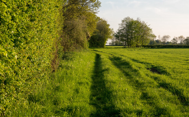
The woodland is characterized by a diverse range of tree species, including ancient oaks, beech, and birch trees, which provide a rich habitat for a variety of flora and fauna. The forest floor is adorned with carpets of bluebells and wildflowers during the spring, creating a stunning display of natural beauty.

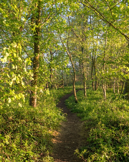
Bull's Wood is intersected by a network of well-maintained walking trails, allowing visitors to explore its enchanting surroundings. The paths wind through the dense foliage, offering glimpses of hidden ponds and streams that add to the tranquility of the area. Wildlife is abundant, with sightings of deer, foxes, and a plethora of bird species being common.

The wood has a fascinating history, with evidence of human habitation dating back to the Neolithic period. Archaeological findings include flint tools and pottery fragments, indicating that the area was once frequented by ancient settlers.

Today, Bull's Wood is managed by a local conservation group, ensuring the protection and preservation of its natural wonders. Educational programs and guided tours are often organized, providing visitors with the opportunity to learn about the woodland's biodiversity and its importance for the local ecosystem.

Overall, Bull's Wood is a serene and captivating woodland, offering a peaceful retreat and a chance to immerse oneself in the beauty of nature.

If you have any feedback on the listing, please let us know in the comments section below.

Bull's Wood Images

Images are sourced within 2km of 52.156849/0.81178882 or Grid Reference TL9254. Thanks to Geograph Open Source API. All images are credited.

Little green at Cockfield
Footpath on Field Boundary, Thorpe Green The path leads to Bull's Wood Nature Reserve - <a href="https://www.geograph.org.uk/photo/7477940">TL9254 : Path in Bull's Wood, Cockfield</a>
Footpath on Field Boundary, Thorpe Green
The path leads to Bull's Wood Nature Reserve - TL9254 : Path in Bull's Wood, Cockfield
Path in Bull's Wood, Cockfield Bull's Wood Nature Reserve is is part of the Thorpe Morieux Woods Site of Special Scientific Interest and is managed by the Suffolk Wildlife Trust: <span class="nowrap"><a title="https://www.suffolkwildlifetrust.org/bullswood" rel="nofollow ugc noopener" href="https://www.suffolkwildlifetrust.org/bullswood">Link</a><img style="margin-left:2px;" alt="External link" title="External link - shift click to open in new window" src="https://s1.geograph.org.uk/img/external.png" width="10" height="10"/></span> . They say:

"The wood is famed countrywide for its rare spring-time oxlips, which are limited to just 100 sites in East Anglia, carpeting swathes of the woodland floor in buttery yellow. Anyone visiting between March and June will also be treated to abundant displays of early-purple orchid, spurge-laurel, wood anemone and herb-paris. Yet, the spectacular show of flowers is certainly not the only reason to visit Bull’s Wood.

The circular walk that winds past traditionally managed coppices of hazel and ash, takes you through lush rides opened up for butterflies such as the gatekeeper, speckled wood and orange tip. Birds such as marsh tits, long-tailed tits and tree-creeper can also be regularly seen. The walk itself is relatively short and can be completed in about 15 minutes. But with the only other foot prints you are likely to see belonging to the wood’s roe deer, there is plenty of opportunity just to stand and stare."
Path in Bull's Wood, Cockfield
Bull's Wood Nature Reserve is is part of the Thorpe Morieux Woods Site of Special Scientific Interest and is managed by the Suffolk Wildlife Trust: LinkExternal link . They say: "The wood is famed countrywide for its rare spring-time oxlips, which are limited to just 100 sites in East Anglia, carpeting swathes of the woodland floor in buttery yellow. Anyone visiting between March and June will also be treated to abundant displays of early-purple orchid, spurge-laurel, wood anemone and herb-paris. Yet, the spectacular show of flowers is certainly not the only reason to visit Bull’s Wood. The circular walk that winds past traditionally managed coppices of hazel and ash, takes you through lush rides opened up for butterflies such as the gatekeeper, speckled wood and orange tip. Birds such as marsh tits, long-tailed tits and tree-creeper can also be regularly seen. The walk itself is relatively short and can be completed in about 15 minutes. But with the only other foot prints you are likely to see belonging to the wood’s roe deer, there is plenty of opportunity just to stand and stare."
B17 Crash Site Memorial B17 G, Ser: 42-38085 of the 711st Bomb Squadron of the 447th Bomb Group (Heavy) from USAAF Station Rattlesden crashed here on the 27th of March 1944 killing all on board.
1st Lt. W.C. Hudson, Pilot; 2nd Lt. W.B. Corley, Co-pilot; 2nd Lt. N. Bishusky, Navigator; 2nd Lt. J.C. Henix Jr., Bombardier; T. Sgt. J.C. Cunningham, Eng'r/ Top Turret; T. Sgt. D.N. Jugenberg, R/Operator; S/Sgt. C.E. Gorman, B/Turret; S/Sgt. L.A. St. Laurent, L/Waist Gnr; S/Sgt. J.C. Badenhoffer, R/Waist Gnr; S/Sgt. J. Penwell, Tail Gunner.
B17 Crash Site Memorial
B17 G, Ser: 42-38085 of the 711st Bomb Squadron of the 447th Bomb Group (Heavy) from USAAF Station Rattlesden crashed here on the 27th of March 1944 killing all on board. 1st Lt. W.C. Hudson, Pilot; 2nd Lt. W.B. Corley, Co-pilot; 2nd Lt. N. Bishusky, Navigator; 2nd Lt. J.C. Henix Jr., Bombardier; T. Sgt. J.C. Cunningham, Eng'r/ Top Turret; T. Sgt. D.N. Jugenberg, R/Operator; S/Sgt. C.E. Gorman, B/Turret; S/Sgt. L.A. St. Laurent, L/Waist Gnr; S/Sgt. J.C. Badenhoffer, R/Waist Gnr; S/Sgt. J. Penwell, Tail Gunner.
B17 Crash Site Memorial For more details please see <a title="https://www.geograph.org.uk/photo/5519479" href="https://www.geograph.org.uk/photo/5519479">Link</a>
B17 Crash Site Memorial
For more details please see Link
B17 Crash site plaque This plaque is attached to the wall of the reservoir pumping station. A general view can be seen here <a title="https://www.geograph.org.uk/photo/5519509" href="https://www.geograph.org.uk/photo/5519509">Link</a>

For more details please see <a title="https://www.geograph.org.uk/photo/5519479" href="https://www.geograph.org.uk/photo/5519479">Link</a>
B17 Crash site plaque
This plaque is attached to the wall of the reservoir pumping station. A general view can be seen here Link For more details please see Link
Reservoir pumping Station On which can be seen two plaques in memory of the crews lost from two B17 Flying Fortresses in 1944
For a close view <a title="https://www.geograph.org.uk/photo/5519512" href="https://www.geograph.org.uk/photo/5519512">Link</a>
Details of the plaques <a title="https://www.geograph.org.uk/photo/5519498" href="https://www.geograph.org.uk/photo/5519498">Link</a> /
Reservoir pumping Station
On which can be seen two plaques in memory of the crews lost from two B17 Flying Fortresses in 1944 For a close view Link Details of the plaques Link /
B17 Flying Fortress crash site memorial plaques Close-up of <a title="https://www.geograph.org.uk/photo/5519509" href="https://www.geograph.org.uk/photo/5519509">Link</a>
Plaque details <a title="https://www.geograph.org.uk/photo/5519498" href="https://www.geograph.org.uk/photo/5519498">Link</a> and <a title="https://www.geograph.org.uk/photo/5519538" href="https://www.geograph.org.uk/photo/5519538">Link</a>
B17 Flying Fortress crash site memorial plaques
Close-up of Link Plaque details Link and Link
B17 Crash site plaque #2 B17 Ser: 42-31088 'Heaven can Wait' of the 711st Bomb Squadron of the 447th Bomb Group from USAAF Station Rattlesden crashed here on the 12th of April 1944 killing seven of the ten men on board.
2nd Lt. P.D. King, Pilot; 2nd Lt. J.F. Dillon, Co-Pilot; 2nd Lt. C.V. Anderson, Navigator; 2nd Lt. J.M. Pruner, Bombardier; S/Sgt. W.H. Harrison, Eng'r/ Top Turret; S/Sgt L.A. Boltz, R/Operator; Sgt. D.A. Campbell, L/Waist Gnr.

This plaque is attached to the wall of the reservoir pumping station. A general view can be seen here <a title="https://www.geograph.org.uk/photo/5519509" href="https://www.geograph.org.uk/photo/5519509">Link</a>
B17 Crash site plaque #2
B17 Ser: 42-31088 'Heaven can Wait' of the 711st Bomb Squadron of the 447th Bomb Group from USAAF Station Rattlesden crashed here on the 12th of April 1944 killing seven of the ten men on board. 2nd Lt. P.D. King, Pilot; 2nd Lt. J.F. Dillon, Co-Pilot; 2nd Lt. C.V. Anderson, Navigator; 2nd Lt. J.M. Pruner, Bombardier; S/Sgt. W.H. Harrison, Eng'r/ Top Turret; S/Sgt L.A. Boltz, R/Operator; Sgt. D.A. Campbell, L/Waist Gnr. This plaque is attached to the wall of the reservoir pumping station. A general view can be seen here Link
Reservoir at Thorpe Morieux
Rowing boat on the reservoir at Thorpe Morieux
A long way from home? Ravensthorpe Water is in Northamptonshire 80 miles away.
A long way from home?
Ravensthorpe Water is in Northamptonshire 80 miles away.
Hawthorn berries
Hawthorn berries
Boat on a reservoir The boat was originally on Grafham water before it was brought here.
Boat on a reservoir
The boat was originally on Grafham water before it was brought here.
The old chapel at Thorpe Morieux looking very smart
Felsham: Three Grange Farm
Show me another place!

Bull's Wood is located at Grid Ref: TL9254 (Lat: 52.156849, Lng: 0.81178882)

Administrative County: Suffolk

District: Babergh

Police Authority: Suffolk

What 3 Words

///guesswork.commit.weds. Near Lavenham, Suffolk

Nearby Locations

Bull's Wood

Related Wikis

Bull's Wood

Bull's Wood is a 12 hectare nature reserve east of Cockfield in Suffolk, England. It is managed by the Suffolk Wildlife Trust, and is part of the Thorpe...

Cockfield, Suffolk

Cockfield is a village and civil parish located approximately 3+1⁄2 miles (5.6 km) from Lavenham in Suffolk, England. The village consists of a central...

Thorpe Morieux Woods

Thorpe Morieux Woods is a 45.2-hectare (112-acre) biological Site of Special Scientific Interest north of Thorpe Morieux in Suffolk. Part of it is Bull...

Cockfield railway station

Cockfield railway station was on the Long Melford-Bury St Edmunds branch line in Cockfield, Suffolk. The station building still stands, but is in a semi...

Cockfield Windmill

Cockfield Mill is a tower mill at Cockfield, Suffolk, England, which has been converted to residential accommodation. == History == Cockfield Mill was...

Thorpe Morieux

Thorpe Morieux ( Mə-ROO) is a small village and civil parish in Suffolk, England. It is 10 miles south-east of Bury St Edmunds and 10 miles north east...

Bradfield Woods

Bradfield Woods is an 81.4-hectare (201-acre) biological Site of Special Scientific Interest between Bury St Edmunds and Stowmarket in Suffolk. The site...

Windsor Green

Windsor Green is a hamlet in the civil parish of Cockfield, in the Babergh district of the county of Suffolk, England. It is about four miles away from...

Nearby Amenities

Located within 500m of 52.156849,0.81178882
The data included in this document is from www.openstreetmap.org. The data is made available under ODbL.

Have you been to Bull's Wood?

Leave your review of Bull's Wood below (or comments, questions and feedback).