Sett's Wood

Wood, Forest in Kent Ashford

England

Sett's Wood

Ramsden Oast, Reading Street Single round kiln oast house. Black weatherboard stowage.

Keywords: roundel, hop drying, beer, weatherboard, tenterden, converted, house
Ramsden Oast, Reading Street Credit: Julian P Guffogg

Sett's Wood is a picturesque woodland located in the county of Kent, England. Covering an area of approximately 100 acres, this ancient woodland is a haven for nature enthusiasts and those seeking tranquility amidst the beauty of nature.

The wood is predominantly composed of native broadleaf trees, including oak, beech, ash, and birch, which create a diverse and rich ecosystem. The dense canopy formed by these trees allows only dappled sunlight to filter through, casting a magical glow on the forest floor. This creates an ideal habitat for a wide variety of flora and fauna.

Walking through Sett's Wood, visitors can enjoy the peaceful ambiance as they traverse the well-maintained footpaths. The woodland is home to an array of wildlife, including deer, foxes, badgers, and an abundance of bird species. Birdwatchers can spot species such as robins, blue tits, and woodpeckers, among others.

Sett's Wood also boasts a diverse range of plant life, with carpets of bluebells in the spring and a vibrant display of wildflowers in the summer months. Ferns, mosses, and lichens thrive in the damp, shaded areas, adding to the wood's enchanting allure.

The wood is open to the public year-round, and its peaceful setting attracts walkers, joggers, and nature lovers alike. Sett's Wood is a valuable natural resource, providing a sanctuary for wildlife and a place for visitors to connect with nature and find solace in its serene surroundings.

If you have any feedback on the listing, please let us know in the comments section below.
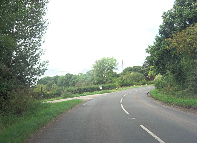
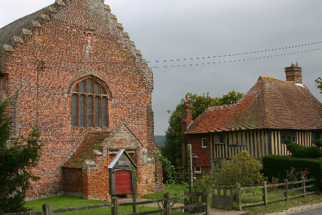
Sett's Wood Images

Images are sourced within 2km of 51.051892/0.7163981 or Grid Reference TQ9031. Thanks to Geograph Open Source API. All images are credited.

Ramsden Oast, Reading Street Single round kiln oast house. Black weatherboard stowage.

Keywords: roundel, hop drying, beer, weatherboard, tenterden, converted, house
Ramsden Oast, Reading Street
Single round kiln oast house. Black weatherboard stowage. Keywords: roundel, hop drying, beer, weatherboard, tenterden, converted, house
B2080 near Frenchay Farm The B2080 is a road of several names: Tenterden Road leaving Appledore and Appledore Road approaching Tenterden make sense but why Reading Street between the two?
B2080 near Frenchay Farm
The B2080 is a road of several names: Tenterden Road leaving Appledore and Appledore Road approaching Tenterden make sense but why Reading Street between the two?
B2080 at Leigh Green
Tenterden, Appledore Road (B2080)
Tenterden, Appledore Road (B2080) Tenterden, Appledore Road (B2080) near Barrack Farm.
Tenterden, Appledore Road (B2080)
Tenterden, Appledore Road (B2080) near Barrack Farm.
Tenterden, Appledore Road (B2080) Tenterden, Appledore Road (B2080) near Spring Farm Cottages.
Tenterden, Appledore Road (B2080)
Tenterden, Appledore Road (B2080) near Spring Farm Cottages.
Tenterden, Appledore Road (B2080) Tenterden, Appledore Road (B2080), Reading Street visible in the distance.
Tenterden, Appledore Road (B2080)
Tenterden, Appledore Road (B2080), Reading Street visible in the distance.
Tenterden, Reading Street (B2080) Tenterden, Reading Street (B2080), Little Ramsden Oast visible in the distance.
Tenterden, Reading Street (B2080)
Tenterden, Reading Street (B2080), Little Ramsden Oast visible in the distance.
Tenterden, Reading Street (B2080) Tenterden, Reading Street (B2080), Little Ramsden Oast visible in the distance.
Tenterden, Reading Street (B2080)
Tenterden, Reading Street (B2080), Little Ramsden Oast visible in the distance.
Tenterden, Reading Street (B2080) Tenterden, Reading Street (B2080), Little Ramsden Oasthouse.
Tenterden, Reading Street (B2080)
Tenterden, Reading Street (B2080), Little Ramsden Oasthouse.
Coneyboro Wood
Coneyboro Wood
Coneyboro Wood
Coneyboro Wood
High Weald Landscape Trail The High Weald Landscape Trail (HWLT) is a 90 mile route between Horsham, West Sussex and Rye, East Sussex, designed to pass through the main landscape types of the High Weald Area of Outstanding Natural Beauty (AONB). It does not follow the highest ground, and the eastern section is only a few feet above sea level. It keeps to the northern edge of the High Weald except in the west where it runs close to the southern edge for a short distance.
It is a trail of regional importance supported by the High Weald Forum and local authorities in East and West Sussex, and Kent. The route is well signposted. It follows public rights of way and roads with the occasional permissive path.
The geology is alternating sandstones and clays, and the latter can be very muddy in wet conditions so boots are a must except in very dry weather. Some sections become very overgrown in summer with nettles and brambles.
High Weald Landscape Trail
The High Weald Landscape Trail (HWLT) is a 90 mile route between Horsham, West Sussex and Rye, East Sussex, designed to pass through the main landscape types of the High Weald Area of Outstanding Natural Beauty (AONB). It does not follow the highest ground, and the eastern section is only a few feet above sea level. It keeps to the northern edge of the High Weald except in the west where it runs close to the southern edge for a short distance. It is a trail of regional importance supported by the High Weald Forum and local authorities in East and West Sussex, and Kent. The route is well signposted. It follows public rights of way and roads with the occasional permissive path. The geology is alternating sandstones and clays, and the latter can be very muddy in wet conditions so boots are a must except in very dry weather. Some sections become very overgrown in summer with nettles and brambles.
Footbridge, High Weald Landscape Trail The High Weald Landscape Trail (HWLT) is a 90 mile route between Horsham, West Sussex and Rye, East Sussex, designed to pass through the main landscape types of the High Weald Area of Outstanding Natural Beauty (AONB). It does not follow the highest ground, and the eastern section is only a few feet above sea level. It keeps to the northern edge of the High Weald except in the west where it runs close to the southern edge for a short distance.
It is a trail of regional importance supported by the High Weald Forum and local authorities in East and West Sussex, and Kent. The route is well signposted. It follows public rights of way and roads with the occasional permissive path.
The geology is alternating sandstones and clays, and the latter can be very muddy in wet conditions so boots are a must except in very dry weather. Some sections become very overgrown in summer with nettles and brambles.
Footbridge, High Weald Landscape Trail
The High Weald Landscape Trail (HWLT) is a 90 mile route between Horsham, West Sussex and Rye, East Sussex, designed to pass through the main landscape types of the High Weald Area of Outstanding Natural Beauty (AONB). It does not follow the highest ground, and the eastern section is only a few feet above sea level. It keeps to the northern edge of the High Weald except in the west where it runs close to the southern edge for a short distance. It is a trail of regional importance supported by the High Weald Forum and local authorities in East and West Sussex, and Kent. The route is well signposted. It follows public rights of way and roads with the occasional permissive path. The geology is alternating sandstones and clays, and the latter can be very muddy in wet conditions so boots are a must except in very dry weather. Some sections become very overgrown in summer with nettles and brambles.
Trees by Tilder Gill
Stile by the High Weald Landscape Trail
Farmland by Tilder Gill
High Weald Landscape Trail The High Weald Landscape Trail (HWLT) is a 90 mile route between Horsham, West Sussex and Rye, East Sussex, designed to pass through the main landscape types of the High Weald Area of Outstanding Natural Beauty (AONB). It does not follow the highest ground, and the eastern section is only a few feet above sea level. It keeps to the northern edge of the High Weald except in the west where it runs close to the southern edge for a short distance.
It is a trail of regional importance supported by the High Weald Forum and local authorities in East and West Sussex, and Kent. The route is well signposted. It follows public rights of way and roads with the occasional permissive path.
The geology is alternating sandstones and clays, and the latter can be very muddy in wet conditions so boots are a must except in very dry weather. Some sections become very overgrown in summer with nettles and brambles.
High Weald Landscape Trail
The High Weald Landscape Trail (HWLT) is a 90 mile route between Horsham, West Sussex and Rye, East Sussex, designed to pass through the main landscape types of the High Weald Area of Outstanding Natural Beauty (AONB). It does not follow the highest ground, and the eastern section is only a few feet above sea level. It keeps to the northern edge of the High Weald except in the west where it runs close to the southern edge for a short distance. It is a trail of regional importance supported by the High Weald Forum and local authorities in East and West Sussex, and Kent. The route is well signposted. It follows public rights of way and roads with the occasional permissive path. The geology is alternating sandstones and clays, and the latter can be very muddy in wet conditions so boots are a must except in very dry weather. Some sections become very overgrown in summer with nettles and brambles.
Show me another place!

Sett's Wood is located at Grid Ref: TQ9031 (Lat: 51.051892, Lng: 0.7163981)

Administrative County: Kent

District: Ashford

Police Authority: Kent

What 3 Words

///popular.buzzards.latched. Near Tenterden, Kent

Related Wikis

Leigh Green

Leigh Green is a hamlet 2 miles (3 km) southeast of the town of Tenterden in Kent, England .

Small Hythe

Small Hythe (or Smallhythe) is a hamlet near Tenterden in Kent, England. The population is included in Tenterden. It stood on a branch of the Rother estuary...

Chapel Down

Chapel Down based in Tenterden in Kent, is an English vineyard and winemaker. It is the largest producer of English wine, with over 950 acres under vine...

Smallhythe Place

Smallhythe Place in Small Hythe, near Tenterden in Kent, is a half-timbered house built in the late 15th or early 16th century and since 1947 cared for...

Nearby Amenities

Located within 500m of 51.051892,0.7163981
The data included in this document is from www.openstreetmap.org. The data is made available under ODbL.

Have you been to Sett's Wood?

Leave your review of Sett's Wood below (or comments, questions and feedback).