Conyfield Wood

Wood, Forest in Essex Colchester

England

Conyfield Wood

Barn, Messing The barn stands beside the private drive to Bouchiers Hall.
Barn, Messing Credit: Trevor Harris

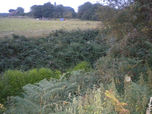
Conyfield Wood is a picturesque woodland located in the county of Essex, England. Situated in the southeast of the county, it covers an area of approximately 30 hectares. The wood is predominantly composed of deciduous trees, including oak, birch, and beech, which create a vibrant and diverse ecosystem.

The woodland is characterized by its enchanting beauty, with a dense canopy that provides a sheltered and tranquil environment. It is a popular destination for nature enthusiasts and walkers, who are drawn to its peaceful atmosphere and scenic surroundings. The wood boasts a network of well-maintained pathways and trails, allowing visitors to explore its various corners and discover its hidden treasures.

Conyfield Wood is also home to a wide array of wildlife. The woodland provides a habitat for numerous species of birds, such as woodpeckers, owls, and warblers, which can be observed and heard throughout the year. Additionally, the wood supports a variety of mammals, including foxes, rabbits, and squirrels, which thrive within its protective boundaries.

Throughout the seasons, Conyfield Wood showcases a stunning display of nature's changing colors. In spring, the woodland bursts with vibrant wildflowers and blossoming trees, while autumn paints the forest floor with a rich carpet of fallen leaves. The wood is especially captivating in winter when a dusting of snow blankets the landscape, creating a magical and ethereal ambiance.

Overall, Conyfield Wood offers visitors a chance to escape the hustle and bustle of everyday life and immerse themselves in the beauty of nature. Whether exploring its winding paths, observing its diverse wildlife, or simply enjoying a peaceful stroll, this woodland is a haven for those seeking tranquility and a connection with the natural world.

If you have any feedback on the listing, please let us know in the comments section below.

Conyfield Wood Images

Images are sourced within 2km of 51.828492/0.75336988 or Grid Reference TL8918. Thanks to Geograph Open Source API. All images are credited.

Barn, Messing The barn stands beside the private drive to Bouchiers Hall.
Barn, Messing
The barn stands beside the private drive to Bouchiers Hall.
Domsey Brook Taken from the footbridge which carries the path to Scottie's Farm. The brook is a tributary of the River Blackwater which it joins at Kelvedon.
Domsey Brook
Taken from the footbridge which carries the path to Scottie's Farm. The brook is a tributary of the River Blackwater which it joins at Kelvedon.
Tiptree: 'Springfields' show home
Tiptree: Heathland Avenue
Tiptree: Grange Road
Pond at Messing Lodge The Lodge itself can be glimpsed through the trees ahead. Taken on Lodge Road.
Pond at Messing Lodge
The Lodge itself can be glimpsed through the trees ahead. Taken on Lodge Road.
Tiptree URC The back entrance of Tiptree United Reformed Church
Tiptree URC
The back entrance of Tiptree United Reformed Church
Giant Sequoioa One of four on the track going down Pods Wood.
Giant Sequoioa
One of four on the track going down Pods Wood.
Bluebells in Pods wood Growing in bettwen the birch trees
Bluebells in Pods wood
Growing in bettwen the birch trees
A very overgrown rampart The rampart is a deep ditch dug by the Romans. It was used to defend the Romans from another army.
A very overgrown rampart
The rampart is a deep ditch dug by the Romans. It was used to defend the Romans from another army.
Wheat field near Layer Lakes In winter this is just grass.
Wheat field near Layer Lakes
In winter this is just grass.
Pathway looking towards the Rampart The rampart is a defensive ditch <a href="https://www.geograph.org.uk/photo/2801512">TL9017 : A very overgrown rampart</a>
Pathway looking towards the Rampart
The rampart is a defensive ditch TL9017 : A very overgrown rampart
Shooting tower
Shooting tower
Pods Wood in spring Blue bells
Pods Wood in spring
Blue bells
Looking along the ramparts The Ramparts Layer Marney
Looking along the ramparts
The Ramparts Layer Marney
Lodge Road The road beside Messing Lodge which gives it its name. The finger post for the footpath to Scottie's Farm can be seen in the distance beside the road.
Lodge Road
The road beside Messing Lodge which gives it its name. The finger post for the footpath to Scottie's Farm can be seen in the distance beside the road.
Paths cross in Pods Wood, Messing Pods Wood is managed by the Forestry Commission.
Paths cross in Pods Wood, Messing
Pods Wood is managed by the Forestry Commission.
Pond in Pods Wood, Messing Pods Wood is managed by the Forestry Commission.
Pond in Pods Wood, Messing
Pods Wood is managed by the Forestry Commission.
Show me another place!

Conyfield Wood is located at Grid Ref: TL8918 (Lat: 51.828492, Lng: 0.75336988)

Administrative County: Essex

District: Colchester

Police Authority: Essex

What 3 Words

///shiver.prune.confusion. Near Tiptree, Essex

Related Wikis

Messing, Essex

Messing is a village and former civil parish, 14 miles (23 km) north east of Chelmsford, now in the parish of Messing-cum-Inworth, in the Colchester district...

Messing-cum-Inworth

Messing-cum-Inworth is a civil parish in the Colchester district, in north-east Essex, 8.5 miles west of Colchester, and 15 miles east of Chelmsford. The...

Thurstable School

Thurstable School is a mixed (ages 11–18) secondary academy school, situated in the village of Tiptree, Essex, England. The school is about 8 miles south...

Messing Maypole Mill

Messing Maypole Mill is a grade II listed Tower mill at Tiptree, Essex, England which has been converted to a residence. Prior to boundary changes made...

Nearby Amenities

Located within 500m of 51.828492,0.75336988
Barrier: stile
Lat/Long: 51.8284918/0.7516766
Barrier: stile
Lat/Long: 51.8282435/0.7504112
Barrier: stile
Lat/Long: 51.8244171/0.7532967
Barrier: stile
Lat/Long: 51.8275834/0.749952
Barrier: stile
Lat/Long: 51.8261196/0.7515371
Barrier: stile
Lat/Long: 51.8256008/0.752036
Barrier: stile
Lat/Long: 51.8268474/0.7507673
Power: pole
Lat/Long: 51.832612/0.7561549
Power: pole
Lat/Long: 51.8320617/0.7571563
Power: pole
Lat/Long: 51.8315057/0.7581514
Power: pole
Lat/Long: 51.8309468/0.7591356
Colour: red and white
Description: temporary
Marker: aerial
Material: plastic
Utility: gas
Lat/Long: 51.8307876/0.7493764
Colour: yellow
Description: temporary
Marker: post
Material: plastic
Utility: gas
Lat/Long: 51.8307757/0.7492973
The data included in this document is from www.openstreetmap.org. The data is made available under ODbL.

Have you been to Conyfield Wood?

Leave your review of Conyfield Wood below (or comments, questions and feedback).