Doctor's Plantation
Wood, Forest in Norfolk King's Lynn and West Norfolk
England
Doctor's Plantation

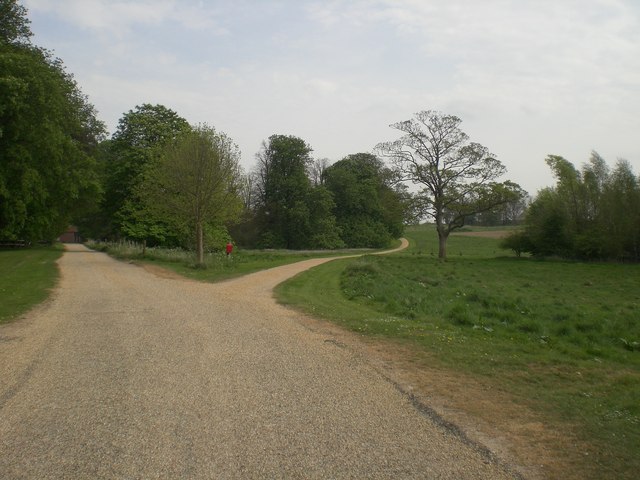
Doctor's Plantation, Norfolk, also known as Wood or Forest, is a notable woodlands area located in the county of Norfolk, England. Spanning approximately 200 acres, this plantation is a significant natural asset to the region, comprising a diverse range of tree species and serving as a haven for wildlife.
The woodland is situated in the eastern part of Norfolk, near the village of Doctor's Common. It is characterized by its dense tree cover, featuring a mixture of deciduous and coniferous trees, including oak, beech, pine, and birch. This varied tree composition provides a rich habitat for numerous bird species, small mammals, and insects, making it an ideal location for nature enthusiasts and wildlife conservationists.
Within the plantation, there are several well-maintained walking trails that offer visitors the opportunity to explore the woodland's beauty and tranquility. The paths wind through the trees, providing glimpses of picturesque landscapes and allowing visitors to immerse themselves in the natural surroundings. These trails are also accessible for wheelchair users, ensuring that everyone can enjoy the plantation's splendor.
Doctor's Plantation is managed by the local authorities, who actively work to preserve and enhance its natural features. Conservation efforts include regular tree maintenance, clearing invasive species, and promoting biodiversity. The woodland also serves as an educational resource, with local schools and community groups often organizing visits to learn about the importance of forests and environmental conservation.
Overall, Doctor's Plantation in Norfolk is a cherished natural gem, appreciated for its beauty, biodiversity, and recreational opportunities. Whether it's a leisurely walk, birdwatching, or simply seeking solace in nature, this woodland offers a serene retreat for visitors of all ages.
If you have any feedback on the listing, please let us know in the comments section below.
Doctor's Plantation Images
Images are sourced within 2km of 52.902219/0.74599115 or Grid Reference TF8437. Thanks to Geograph Open Source API. All images are credited.


Doctor's Plantation is located at Grid Ref: TF8437 (Lat: 52.902219, Lng: 0.74599115)
Administrative County: Norfolk
District: King's Lynn and West Norfolk
Police Authority: Norfolk
What 3 Words
///narrating.warriors.spends. Near Wells-next-the-Sea, Norfolk
Nearby Locations
Related Wikis

North Creake
North Creake is a village and civil parish in the north west of the English county of Norfolk. It covers an area of 14.99 km2 (5.79 sq mi) and had a population...

Bloodgate Hill Iron Age Fort
The Bloodgate Hill Iron Age Fort is an Iron Age hill fort in Norfolk, England, situated on a hill above the village of South Creake in the north of the...

Creake Abbey
Creake Abbey is a ruined abbey in Norfolk, England, situated alongside the River Burn and a mile to the north of the village of North Creake. The abbey...

South Creake
South Creake is a village and civil parish in north west Norfolk, England. The village lies 1+1⁄2 miles (2.4 km) south of its twin village of North Creake...
Quarles, Norfolk
Quarles is a hamlet and former civil parish, now in the civil parish of Holkham, in the North Norfolk district, in the county of Norfolk, England. The...

Burnham Thorpe
Burnham Thorpe is a hamlet and civil parish on the River Burn and near the coast of Norfolk, England. It is famous for being the birthplace of Vice Admiral...
Waterden medieval settlement
Waterden medieval settlement is a deserted medieval village in Norfolk, England, about 3 miles (4.8 km) west of Walsingham. It is a Scheduled Monument...

Burnham Market railway station
Burnham Market was a railway station which served the village of Burnham Market in Norfolk, England. Opened by the West Norfolk Junction railway in 1866...
Nearby Amenities
Located within 500m of 52.902219,0.74599115Have you been to Doctor's Plantation?
Leave your review of Doctor's Plantation below (or comments, questions and feedback).