Austen's Wood

Wood, Forest in Sussex Rother

England

Austen's Wood

The Ornamental Pond Ornamental pond in the garden of "The Patched Gloves", Chitcombe Road.
The Ornamental Pond Credit: David Wright

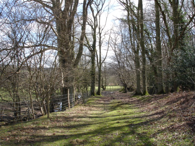
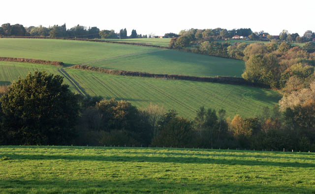
Austen's Wood is a picturesque forest located in the county of Sussex, England. With its lush greenery and ancient trees, it is a haven for nature lovers and outdoor enthusiasts. The wood covers an area of approximately 100 acres and is part of the wider Ashdown Forest, which is a designated Area of Outstanding Natural Beauty.

The forest is home to a variety of tree species, including oak, beech, and birch, creating a diverse and vibrant ecosystem. The towering trees provide a canopy of shade, creating a peaceful and serene atmosphere. In spring, the forest floor is carpeted with bluebells, creating a breathtaking display of color.

Austen's Wood offers numerous walking trails, allowing visitors to explore its natural beauty. These trails range in difficulty, catering to both casual strollers and avid hikers. The forest is also a popular spot for birdwatching, with a wide range of species calling it home, including woodpeckers, owls, and various songbirds.

History buffs will appreciate the ancient origins of Austen's Wood. The forest has been standing for centuries and has witnessed the passage of time. It is believed to have been part of the medieval hunting grounds of the Ashdown Forest, once frequented by the royalty of England.

Overall, Austen's Wood is a must-visit destination for those seeking tranquility and a connection with nature. Its beauty and historical significance make it a truly enchanting place to explore.

If you have any feedback on the listing, please let us know in the comments section below.

Austen's Wood Images

Images are sourced within 2km of 50.954965/0.5907385 or Grid Reference TQ8220. Thanks to Geograph Open Source API. All images are credited.

The Ornamental Pond Ornamental pond in the garden of "The Patched Gloves", Chitcombe Road.
The Ornamental Pond
Ornamental pond in the garden of "The Patched Gloves", Chitcombe Road.
Farmland Beckley East Sussex Farmland along the River Tillingham looking north towards Beckley Furnace grid square TQ8321.
Farmland Beckley East Sussex
Farmland along the River Tillingham looking north towards Beckley Furnace grid square TQ8321.
Beckley Furnace East Sussex Furnace Lane leading to small Hamlet of Beckley Furnace.In the background is Furnace Wood.
Beckley Furnace East Sussex
Furnace Lane leading to small Hamlet of Beckley Furnace.In the background is Furnace Wood.
Farmland Beckley Furnace East Sussex The Oast across Furnace farmland along the side of Kicker Wood.
Farmland Beckley Furnace East Sussex
The Oast across Furnace farmland along the side of Kicker Wood.
Birch Wood Beckley Furnace East Sussex On the edge of Birch Wood near Beckley Furnace.
Birch Wood Beckley Furnace East Sussex
On the edge of Birch Wood near Beckley Furnace.
The  Oast  Beckley  Furnace  East Sussex The Oast and Furnace Farm is in Furnace Lane Beckley Furnace.
The Oast Beckley Furnace East Sussex
The Oast and Furnace Farm is in Furnace Lane Beckley Furnace.
Spring Time Beckley Furnace East Sussex Furnace Lane looking to The Oast with the primroses showing sure sign spring is here.
Spring Time Beckley Furnace East Sussex
Furnace Lane looking to The Oast with the primroses showing sure sign spring is here.
New House This far from 'new' house straddles a gridline, but the front and gardens are within TQ8122.
New House
This far from 'new' house straddles a gridline, but the front and gardens are within TQ8122.
Farm Buildings at Benedict Farm A functional set of buildings which have been captured to hedge against the borderline New House, in the same, square being rejected.
Farm Buildings at Benedict Farm
A functional set of buildings which have been captured to hedge against the borderline New House, in the same, square being rejected.
St Teresa's Catholic Church A cartographic conundrum; this tiny catholic Church is marked on the OS map as a chapel.
St Teresa's Catholic Church
A cartographic conundrum; this tiny catholic Church is marked on the OS map as a chapel.
Furnace Lane road junction The name of the lane that leads to Furnace Green; both names reminiscent of the Sussex Weald's iron making history.
Furnace Lane road junction
The name of the lane that leads to Furnace Green; both names reminiscent of the Sussex Weald's iron making history.
Fields north of Chitcombe
Rickety Stile close to Broad Oak Not the sort of stile to trust your weight on; this footpath crosses the lane running from New House Farm to Brede High Wood
Rickety Stile close to Broad Oak
Not the sort of stile to trust your weight on; this footpath crosses the lane running from New House Farm to Brede High Wood
Watts Palace Lane, in Hoath Wood Get off the main road and you are immediately into a different world.
Watts Palace Lane, in Hoath Wood
Get off the main road and you are immediately into a different world.
Well hidden picnic spot Foresters often provide facilities for visitors, encouraging appreciation and care for the surprisingly important part played by woodland in the southern landscape.
Well hidden picnic spot
Foresters often provide facilities for visitors, encouraging appreciation and care for the surprisingly important part played by woodland in the southern landscape.
Bridleway? Always make sure that access is legal, whether for 'shanks pony', or four legs, or even for wheeled transport.  Wrong use can spoil the facility for anyone else.
Bridleway?
Always make sure that access is legal, whether for 'shanks pony', or four legs, or even for wheeled transport. Wrong use can spoil the facility for anyone else.
Footpath in Coneyburrow Wood A surprise round every corner. This time it's the foxgloves.
Footpath in Coneyburrow Wood
A surprise round every corner. This time it's the foxgloves.
Oast House Twin round kiln oast house.
Oast House
Twin round kiln oast house.
Show me another place!

Austen's Wood is located at Grid Ref: TQ8220 (Lat: 50.954965, Lng: 0.5907385)

Administrative County: East Sussex

District: Rother

Police Authority: Sussex

What 3 Words

///booster.variously.ordinary. Near Northiam, East Sussex

Related Wikis

Broad Oak, Rother

Broad Oak is a small village in the Rother district, in eastern East Sussex, England, referred to also as Broad Oak Brede, as there is a village with the...

Brede, East Sussex

Brede is a village and civil parish in the Rother district of East Sussex, England. It is located eight miles (13 km) north of Hastings and four miles...

Powdermill Reservoir

Powdermill Reservoir lies to the east of Sedlescombe, East Sussex, England. The reservoir provides water for Southern Water customers. == History == Originally...

Brede Pit and Cutting

Brede Pit and Cutting is a 0.6-hectare (1.5-acre) geological Site of Special Scientific Interest in Brede in East Sussex. It is a Geological Conservation...

Brede Waterworks

Brede Waterworks (grid reference TQ 813 178) is a waterworks at Brede, East Sussex, England. It was built to supply Hastings with drinking water. The waterworks...

Northiam

Northiam is a village and civil parish in the Rother district, in East Sussex, England, 13 miles (21 km) north of Hastings in the valley of the River Rother...

Doleham

Doleham is a small hamlet in East Sussex, England. The hamlet consists of only a handful of houses, and takes its name from Doleham Farm. The area is popular...

Doleham railway station

Doleham railway station is a small, single-platform wayside halt in Doleham, East Sussex, England. It is on the Marshlink line, and train services are...

Nearby Amenities

Located within 500m of 50.954965,0.5907385
Power: tower
Source: Bing
Lat/Long: 50.9565831/0.5858985
Power: tower
Source: Bing
Lat/Long: 50.9534775/0.5850283
Barrier: kissing_gate
Foot: designated
Material: metal
Lat/Long: 50.9582677/0.590425
Barrier: kissing_gate
Foot: designated
Lat/Long: 50.9522802/0.5915232
Fixme: Continue
Lat/Long: 50.9522018/0.5962838
Man Made: mast
Lat/Long: 50.955603/0.5848847
The data included in this document is from www.openstreetmap.org. The data is made available under ODbL.

Have you been to Austen's Wood?

Leave your review of Austen's Wood below (or comments, questions and feedback).