Elveden Lower Warren

Wood, Forest in Suffolk West Suffolk

England

Elveden Lower Warren

A11 towards London On the Elveden Bypass.
A11 towards London Credit: Robin Webster

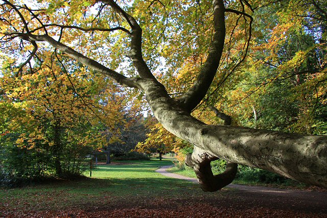
Elveden Lower Warren is a stunning wood located in the county of Suffolk, England. Nestled within the larger Elveden Forest, it covers an area of approximately 200 acres, showcasing a rich and diverse ecosystem.

This woodland is renowned for its picturesque beauty, with tall, majestic trees providing a lush canopy that filters sunlight, creating a tranquil and serene atmosphere. The dominant tree species found in Elveden Lower Warren include oak, beech, and birch, which thrive in the fertile, well-drained soil.

The forest floor is adorned with a multitude of flora, including bluebells, primroses, and wild garlic during the spring season, offering a vibrant display of colors and scents. Various species of ferns and mosses can also be found, adding to the enchanting ambiance.

Elveden Lower Warren is not only a haven for nature enthusiasts but also serves as a habitat for a diverse array of wildlife. Deer, foxes, badgers, and rabbits are commonly spotted, while a variety of bird species, such as woodpeckers and owls, fill the air with their melodious calls.

The wood is open to the public, offering numerous walking trails and paths that wind through the forest, allowing visitors to immerse themselves in the natural beauty and tranquility of the surroundings. It is also a popular destination for photographers, artists, and nature lovers, who seek inspiration and solace in its idyllic setting.

Overall, Elveden Lower Warren in Suffolk is a captivating woodland that captivates with its natural splendor, providing a peaceful escape from the hustle and bustle of everyday life.

If you have any feedback on the listing, please let us know in the comments section below.

Elveden Lower Warren Images

Images are sourced within 2km of 52.398246/0.64517669 or Grid Reference TL8081. Thanks to Geograph Open Source API. All images are credited.

A11 towards London On the Elveden Bypass.
A11 towards London
On the Elveden Bypass.
Tesla Model 3 at Supercharger A lovely location near the Elveden Inn.
Tesla Model 3 at Supercharger
A lovely location near the Elveden Inn.
Thetford Forest near Mayday Farm
Stump row in conifer plantation A line of stumps from the previous crop. Now a rarer feature as stumps are ground up in situ rather than pulled out.
Stump row in conifer plantation
A line of stumps from the previous crop. Now a rarer feature as stumps are ground up in situ rather than pulled out.
Lakenheath Warren Grassy heath. The area is open access land, but only between November and February due to sensitive wildlife, <a href="https://www.geograph.org.uk/photo/7383126">TL7779 : Open access sign</a>. Looking towards the Center Parcs site.
Lakenheath Warren
Grassy heath. The area is open access land, but only between November and February due to sensitive wildlife, TL7779 : Open access sign. Looking towards the Center Parcs site.
Path through Lakenheath Warren Grassy heath, with the number of trees and bushes controlled. The area is open access land, but only between November and February due to sensitive wildlife, <a href="https://www.geograph.org.uk/photo/7383126">TL7779 : Open access sign</a>
Path through Lakenheath Warren
Grassy heath, with the number of trees and bushes controlled. The area is open access land, but only between November and February due to sensitive wildlife, TL7779 : Open access sign
Lakenheath Warren Grassy heath. The area is open access land, but only between November and February due to sensitive wildlife, <a href="https://www.geograph.org.uk/photo/7383126">TL7779 : Open access sign</a>.
Lakenheath Warren
Grassy heath. The area is open access land, but only between November and February due to sensitive wildlife, TL7779 : Open access sign.
Lakenheath Warren Grassy heath. The area is open access land, but only between November and February due to sensitive wildlife, <a href="https://www.geograph.org.uk/photo/7383126">TL7779 : Open access sign</a>
Lakenheath Warren
Grassy heath. The area is open access land, but only between November and February due to sensitive wildlife, TL7779 : Open access sign
Track to Spinks Lodge, Elveden
Trees on the edge of Upper Elvedon Warren
This way to Spinks Lodge, Elvedon
Snow At Centerparcs Looking along the boundary footpath at Centerparcs (just inside the barbed wire) adjoining the Lakenheath SSSI.
Snow At Centerparcs
Looking along the boundary footpath at Centerparcs (just inside the barbed wire) adjoining the Lakenheath SSSI.
Heading towards the Perimeter This is one of the tracks that lead to the perimeter track around Center Parcs.
Heading towards the Perimeter
This is one of the tracks that lead to the perimeter track around Center Parcs.
Forest track Forest track on Parsonage Heath forest.
Forest track
Forest track on Parsonage Heath forest.
Show me another place!

Elveden Lower Warren is located at Grid Ref: TL8081 (Lat: 52.398246, Lng: 0.64517669)

Administrative County: Suffolk

District: West Suffolk

Police Authority: Suffolk

What 3 Words

///bolsters.protest.store. Near Thetford, Norfolk

Nearby Locations

Elveden Lower Warren

Related Wikis

Elveden

Elveden is a village and civil parish in the West Suffolk district of Suffolk in eastern England. In 2005 it had a population of 270. The village is bypassed...

Elveden Hall

Elveden Hall is a large stately home on the Elveden Estate in Elveden, Suffolk, England. The seat of the Earls of Iveagh, it is a Grade II* listed building...

Breckland Farmland

Breckland Farmland is a 13,392.4 hectare biological Site of Special Scientific Interest (SSSI) in many separate areas between Swaffham in Norfolk and Bury...

Weather and Horn Heaths, Eriswell

Weather and Horn Heaths, Eriswell is a 133.3-hectare (329-acre) biological Site of Special Scientific Interest east of Eriswell in Suffolk. It is a Nature...

Breckland Forest

Breckland Forest is an 18,126 hectare biological and geological Site of Special Scientific Interest in many separate areas between Swaffham in Norfolk...

Lakenheath Warren

Lakenheath Warren is a 588.3-hectare (1,454-acre) biological Site of Special Scientific Interest south-east of Lakenheath in Suffolk, England. It is a...

Berner's Heath

Berner's Heath is a 236.9-hectare (585-acre) biological Site of Special Scientific Interest north-east of Icklingham in Suffolk. It is a Nature Conservation...

Brandon Country Park

Brandon Country Park is a country park in Brandon, Suffolk, England. == History == In 1820 Edward Bliss bought Brandon Park house and grounds using wealth...

Nearby Amenities

Located within 500m of 52.398246,0.64517669
Parking
Access: private
Capacity: 1
Capacity Disabled: 1
Lat/Long: 52.3951502/0.6410661
Parking
Access: private
Capacity: 1
Capacity Disabled: 1
Lat/Long: 52.3952034/0.6418322
Recycling
Recycling Cans: yes
Recycling Cardboard: yes
Recycling Glass: yes
Recycling Paper: yes
Recycling Waste: yes
Recycling Type: centre
Lat/Long: 52.3952399/0.6421351
Recycling
Recycling Cans: yes
Recycling Cardboard: yes
Recycling Glass: yes
Recycling Paper: yes
Recycling Waste: yes
Recycling Type: centre
Lat/Long: 52.3950158/0.6439951
Recycling
Recycling Cans: yes
Recycling Cardboard: yes
Recycling Glass: yes
Recycling Paper: yes
Recycling Waste: yes
Recycling Type: centre
Lat/Long: 52.3950836/0.642617
Telephone
Check Date: 2023-06-29
Lat/Long: 52.3950282/0.6407836
Fire Beater
Lat/Long: 52.395029/0.6407968
Waste Basket
Check Date: 2023-06-29
Lat/Long: 52.3950281/0.640816
Bench
Backrest: no
Lat/Long: 52.3950593/0.6408074
Recycling
Recycling Cans: yes
Recycling Cardboard: yes
Recycling Glass: yes
Recycling Paper: yes
Recycling Waste: yes
Recycling Type: centre
Lat/Long: 52.3950673/0.6405293
Waste Basket
Lat/Long: 52.3942915/0.6422369
Life Ring
Emergency: life_ring
Lat/Long: 52.3943487/0.6474702
Life Ring
Emergency: life_ring
Lat/Long: 52.3941524/0.6455654
Telephone
Check Date: 2023-06-29
Lat/Long: 52.3949196/0.6461026
Waste Basket
Check Date: 2023-06-29
Lat/Long: 52.3941417/0.644521
Recycling
Recycling Cans: yes
Recycling Cardboard: yes
Recycling Glass: yes
Recycling Paper: yes
Recycling Waste: yes
Recycling Type: centre
Lat/Long: 52.3948652/0.6458902
Waste Basket
Check Date: 2023-06-29
Lat/Long: 52.3947203/0.6454024
Bench
Backrest: no
Lat/Long: 52.3947539/0.6453427
Fire Beater
Lat/Long: 52.3949162/0.6460695
Life Ring
Emergency: life_ring
Lat/Long: 52.3941557/0.64482
Recycling
Recycling Cans: yes
Recycling Cardboard: yes
Recycling Glass: yes
Recycling Paper: yes
Recycling Waste: yes
Recycling Type: centre
Lat/Long: 52.3949971/0.6471255
Recycling
Recycling Cans: yes
Recycling Cardboard: yes
Recycling Glass: yes
Recycling Paper: yes
Recycling Waste: yes
Recycling Type: centre
Lat/Long: 52.3947239/0.6483389
Waste Basket
Lat/Long: 52.3941777/0.6436259
Fire Hydrant
Emergency: fire_hydrant
Fire Hydrant Diameter: 125
Fire Hydrant Position: green
Fire Hydrant Type: underground
Lat/Long: 52.3950821/0.6424378
Fire Hydrant
Emergency: fire_hydrant
Fire Hydrant Diameter: 125
Fire Hydrant Position: green
Fire Hydrant Type: underground
Lat/Long: 52.3950195/0.6441881
Fire Hydrant
Emergency: fire_hydrant
Lat/Long: 52.3951322/0.6401647
Waste Basket
Lat/Long: 52.3944293/0.6489473
Recycling
Location: overground
Recycling Cans: yes
Recycling Glass Bottles: yes
Recycling Paper: yes
Recycling Plastic: yes
Recycling Type: container
Lat/Long: 52.3947753/0.6451248
The data included in this document is from www.openstreetmap.org. The data is made available under ODbL.

Have you been to Elveden Lower Warren?

Leave your review of Elveden Lower Warren below (or comments, questions and feedback).