Francis Wood

Wood, Forest in Suffolk West Suffolk

England

Francis Wood

Broomagefield Wood Walking a footpath near Rede.
Broomagefield Wood Credit: steven ruffles

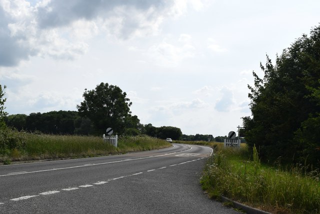
Francis Wood, Suffolk, also known as Wood or Forest, is a small village located in the East Anglia region of England. Situated in the county of Suffolk, it is about 6 miles southwest of the town of Bury St Edmunds. The village is surrounded by picturesque countryside, offering residents and visitors a tranquil and scenic setting.

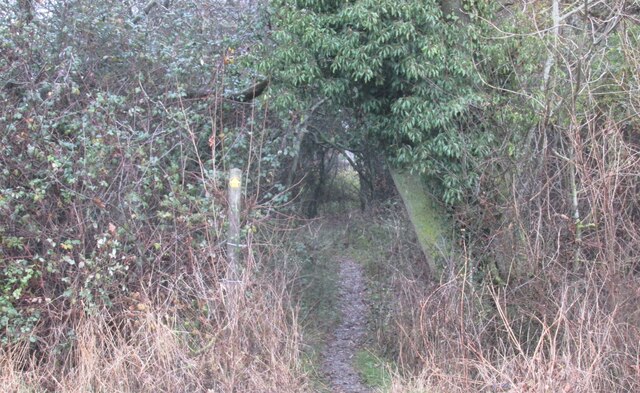
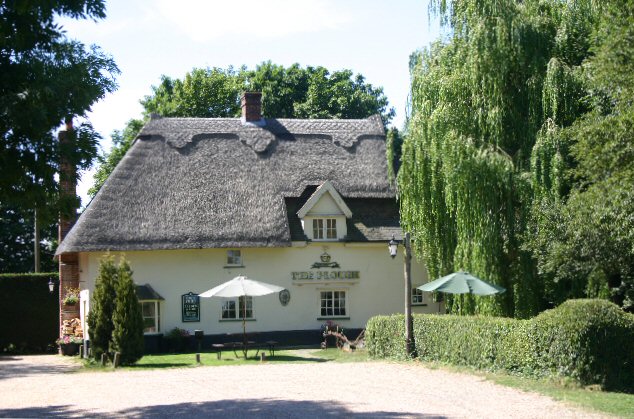
Francis Wood is known for its rich history, dating back to medieval times. It was originally a royal forest, and remnants of its ancient woodland can still be found in the surrounding area. The village has managed to preserve its traditional character, with many old timber-framed buildings and charming thatched cottages lining its streets.

Despite its small size, Francis Wood offers a range of amenities to its residents. These include a village hall, a local pub, and a primary school. The village also benefits from its proximity to larger towns, such as Bury St Edmunds, which provides additional amenities and services.

The natural beauty of Francis Wood and its surroundings makes it a popular destination for outdoor enthusiasts. The village is surrounded by walking and cycling trails, allowing visitors to explore the stunning countryside. Nearby attractions include country parks, nature reserves, and historical sites, providing plenty of opportunities for exploration and discovery.

Overall, Francis Wood, Suffolk, with its charming village atmosphere and beautiful surroundings, offers a peaceful retreat for those seeking a slower pace of life in a picturesque English village.

If you have any feedback on the listing, please let us know in the comments section below.

Francis Wood Images

Images are sourced within 2km of 52.176968/0.6268887 or Grid Reference TL7956. Thanks to Geograph Open Source API. All images are credited.

Broomagefield Wood Walking a footpath near Rede.
Broomagefield Wood
Walking a footpath near Rede.
Footpath through hedge near Rede Hole Taken on a walk to Suffolk's highest ground
Footpath through hedge near Rede Hole
Taken on a walk to Suffolk's highest ground
All Saints' Church, Rede Colourful cottages beside the church.
All Saints' Church, Rede
Colourful cottages beside the church.
Chedburgh War Memorial The memorial is housed in the 'church' for which there is no keyholder. This image was taken through a (thankfully clean) south window.
The memorial bears 19 names of those lost in WW1. No losses are recorded for WW2.
Chedburgh War Memorial
The memorial is housed in the 'church' for which there is no keyholder. This image was taken through a (thankfully clean) south window. The memorial bears 19 names of those lost in WW1. No losses are recorded for WW2.
Field of rye grass, Chedburgh
Road leading to mast The location at the camera position is reckoned to be the Suffolk county top.
Road leading to mast
The location at the camera position is reckoned to be the Suffolk county top.
Walkers along bridleway between fields The pair are heading south-west between fields close to Gatesbury's Farm.
Walkers along bridleway between fields
The pair are heading south-west between fields close to Gatesbury's Farm.
A143 towards Bury St Edmunds In the parish of Depden.
A143 towards Bury St Edmunds
In the parish of Depden.
A143 towards Bury St Edmunds Passing through Depden, although  not much to see on the main road.
A143 towards Bury St Edmunds
Passing through Depden, although not much to see on the main road.
Bury Road, Chedburgh The older part of the village is off to the left.
Bury Road, Chedburgh
The older part of the village is off to the left.
A143 west of Chedburgh Taken from the end of The Street at its junction with the A143.
A143 west of Chedburgh
Taken from the end of The Street at its junction with the A143.
RAF Chedburgh station memorial Opening in September 1942, Chedburgh was one of the earliest operational wartime airfields in Suffolk, it was a satellite bomber station for nearby RAF Stradishall.
Various Units were stationed at RAF Chedburgh in its short history.
620 Squadron was formed at RAF Chedburgh on 17 June 1943 as a heavy bomber squadron equipped with the Short Stirling. It was a part of No.3 Group of RAF Bomber Command and carried out night 61 operations, bombing and minelaying missions until November 1943 when it was transferred to No 38 Group. 
No. 23 Heavy Glider Maintenance Section
No. 214 Squadron RAF flying Handley Page Type O/100 and 400 bombers.
No. 218 Squadron RAF flying Short Sterlings as a transport Unit.
No. 301 Squadron RAF flying Handley Page Halifaxs until they were disbanded in December 1946 
No. 304 Squadron RAF  flying Halifax Mk C.8 unarmed transports and was disbanded a few months later on 18 December 1946.
No. 1653 Heavy Conversion Unit RAF
RAF Chedburgh station memorial
Opening in September 1942, Chedburgh was one of the earliest operational wartime airfields in Suffolk, it was a satellite bomber station for nearby RAF Stradishall. Various Units were stationed at RAF Chedburgh in its short history. 620 Squadron was formed at RAF Chedburgh on 17 June 1943 as a heavy bomber squadron equipped with the Short Stirling. It was a part of No.3 Group of RAF Bomber Command and carried out night 61 operations, bombing and minelaying missions until November 1943 when it was transferred to No 38 Group. No. 23 Heavy Glider Maintenance Section No. 214 Squadron RAF flying Handley Page Type O/100 and 400 bombers. No. 218 Squadron RAF flying Short Sterlings as a transport Unit. No. 301 Squadron RAF flying Handley Page Halifaxs until they were disbanded in December 1946 No. 304 Squadron RAF flying Halifax Mk C.8 unarmed transports and was disbanded a few months later on 18 December 1946. No. 1653 Heavy Conversion Unit RAF
RAF Chedburgh station memorial RAF Chedburgh station memorial
Opening in September 1942, Chedburgh was one of the earliest operational wartime airfields in Suffolk, it was a satellite bomber station for nearby RAF Stradishall.
Various Units were stationed at RAF Chedburgh in its short history.
620 Squadron was formed at RAF Chedburgh on 17 June 1943 as a heavy bomber squadron equipped with the Short Stirling. It was a part of No.3 Group of RAF Bomber Command and carried out night 61 operations, bombing and minelaying missions until November 1943 when it was transferred to No 38 Group.
No. 23 Heavy Glider Maintenance Section
No. 214 Squadron RAF flying Handley Page Type O/100 and 400 bombers.
No. 218 Squadron RAF flying Short Sterlings as a transport Unit.
No. 301 Squadron RAF flying Handley Page Halifaxs until they were disbanded in December 1946
No. 304 Squadron RAF flying Halifax Mk C.8 unarmed transports and was disbanded a few months later on 18 December 1946.
No. 1653 Heavy Conversion Unit RAF
RAF Chedburgh station memorial
RAF Chedburgh station memorial Opening in September 1942, Chedburgh was one of the earliest operational wartime airfields in Suffolk, it was a satellite bomber station for nearby RAF Stradishall. Various Units were stationed at RAF Chedburgh in its short history. 620 Squadron was formed at RAF Chedburgh on 17 June 1943 as a heavy bomber squadron equipped with the Short Stirling. It was a part of No.3 Group of RAF Bomber Command and carried out night 61 operations, bombing and minelaying missions until November 1943 when it was transferred to No 38 Group. No. 23 Heavy Glider Maintenance Section No. 214 Squadron RAF flying Handley Page Type O/100 and 400 bombers. No. 218 Squadron RAF flying Short Sterlings as a transport Unit. No. 301 Squadron RAF flying Handley Page Halifaxs until they were disbanded in December 1946 No. 304 Squadron RAF flying Halifax Mk C.8 unarmed transports and was disbanded a few months later on 18 December 1946. No. 1653 Heavy Conversion Unit RAF
Depden WW1 War Memorial The memorial bears nine names of men lost in the Great War.
Depden WW1 War Memorial
The memorial bears nine names of men lost in the Great War.
Depden village sign Depden is a haven for wildlife if the sign is anything to go by. The church is tucked away in the background and never seen by a passer-by due to its remoteness. The sign features a rather oversize fox who looks about to devour a horse and cart. A cock and hen pheasant survey the scene. The brown hare in the centre is looking butterflies in the blackberry flowers. Nearby a badger peers out of its sett at a hedgehog tucked away in the corner. Flanking the name is Depden windmill which used to stand on Depden Green many years ago and a notable former resident of Depden, Anthony Sparrow (1612-1685) who was Bishop of Exeter and later Bishop of Norwich.
Since this image was taken the painting has been re-modelled and includes another badger, a wren and a robin but has lost the hedgehog. <a title="https://www.geograph.org.uk/photo/4192983" href="https://www.geograph.org.uk/photo/4192983">Link</a>
Incidentally Depden is the highest point in Suffolk, at 128m above sea level. It’s all downhill from here! <a title="https://www.geograph.org.uk/photo/4291801" href="https://www.geograph.org.uk/photo/4291801">Link</a>
Depden village sign
Depden is a haven for wildlife if the sign is anything to go by. The church is tucked away in the background and never seen by a passer-by due to its remoteness. The sign features a rather oversize fox who looks about to devour a horse and cart. A cock and hen pheasant survey the scene. The brown hare in the centre is looking butterflies in the blackberry flowers. Nearby a badger peers out of its sett at a hedgehog tucked away in the corner. Flanking the name is Depden windmill which used to stand on Depden Green many years ago and a notable former resident of Depden, Anthony Sparrow (1612-1685) who was Bishop of Exeter and later Bishop of Norwich. Since this image was taken the painting has been re-modelled and includes another badger, a wren and a robin but has lost the hedgehog. Link Incidentally Depden is the highest point in Suffolk, at 128m above sea level. It’s all downhill from here! Link
Chedburgh village sign The sign depicts an Avro Lancaster of the type based at RAF Chedburgh during World War II.  Below and on the ground, are a pair of heavy horses ploughing the fertile clay soil and a wheatsheaf standing in a field. It is the result of their yearlong labours and symbolic of the agricultural heritage of the parish. <a title="https://www.geograph.org.uk/photo/6767890" href="https://www.geograph.org.uk/photo/6767890">Link</a>
The sign replaced an earlier version <a title="https://www.geograph.org.uk/photo/4291589" href="https://www.geograph.org.uk/photo/4291589">Link</a> with the same theme.
Chedburgh village sign
The sign depicts an Avro Lancaster of the type based at RAF Chedburgh during World War II. Below and on the ground, are a pair of heavy horses ploughing the fertile clay soil and a wheatsheaf standing in a field. It is the result of their yearlong labours and symbolic of the agricultural heritage of the parish. Link The sign replaced an earlier version Link with the same theme.
Chedburgh village sign The sign depicts an Avro Lancaster of the type based at RAF Chedburgh during World War II.  Below and on the ground, are a pair of heavy horses ploughing the fertile clay soil and a wheatsheaf standing in a field. It is the result of their yearlong labours and symbolic of the agricultural heritage of the parish. <a title="https://www.geograph.org.uk/photo/6767889" href="https://www.geograph.org.uk/photo/6767889">Link</a>
The sign replaced an earlier version <a title="https://www.geograph.org.uk/photo/4291589" href="https://www.geograph.org.uk/photo/4291589">Link</a> with the same theme.
Chedburgh village sign
The sign depicts an Avro Lancaster of the type based at RAF Chedburgh during World War II. Below and on the ground, are a pair of heavy horses ploughing the fertile clay soil and a wheatsheaf standing in a field. It is the result of their yearlong labours and symbolic of the agricultural heritage of the parish. Link The sign replaced an earlier version Link with the same theme.
Entrance to Kings Park An exclusive housing complex on the northern outskirts of the village of Chedburgh.
Entrance to Kings Park
An exclusive housing complex on the northern outskirts of the village of Chedburgh.
Show me another place!

Francis Wood is located at Grid Ref: TL7956 (Lat: 52.176968, Lng: 0.6268887)

Administrative County: Suffolk

District: West Suffolk

Police Authority: Suffolk

What 3 Words

///messy.stored.workroom. Near Glemsford, Suffolk

Nearby Locations

Francis Wood

Related Wikis

RAF Chedburgh

Royal Air Force Chedburgh or more simply RAF Chedburgh is a former Royal Air Force satellite station located near Bury St Edmunds, Suffolk, UK. The Bury...

Rede, Suffolk

Rede is a village and civil parish in the West Suffolk district of Suffolk in eastern England. Its location is situated South East of Chedburgh. In 1887...

Newmarket Ridge

The Newmarket Ridge or East Anglian Ridge is a ridge starting north-west of Hertford, Hertfordshire near the Chiltern Hills and ending near Sudbury, Suffolk...

Great Wood Hill

At 128 metres (420 ft), Great Wood Hill, near Chedburgh, is the highest point in the English county of Suffolk. It is the highest part of the Newmarket...

Have you been to Francis Wood?

Leave your review of Francis Wood below (or comments, questions and feedback).