Fring Plantation

Wood, Forest in Norfolk King's Lynn and West Norfolk

England

Fring Plantation

Barley fields near Thornham Corner
Barley fields near Thornham Corner Credit: Jonathan Thacker

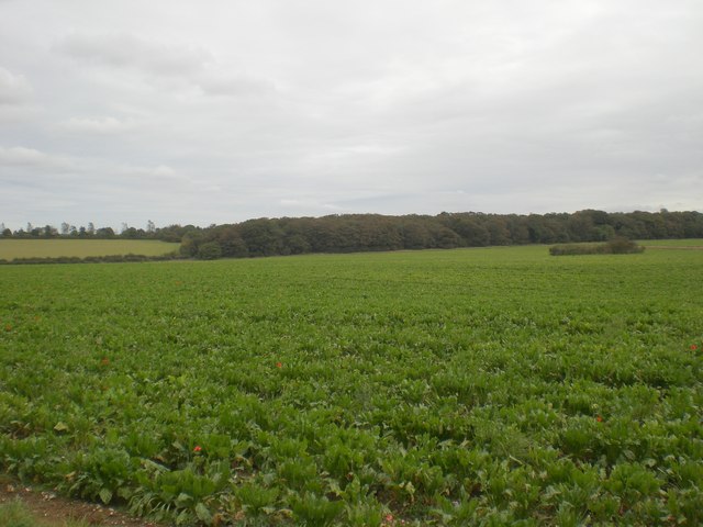
Fring Plantation is a picturesque woodland located in the county of Norfolk, England. Situated near the village of Fring, this plantation covers a vast area of land and is renowned for its diverse range of flora and fauna.

The woodland is predominantly composed of a mixture of broadleaf and coniferous trees, creating a harmonious blend of colors and textures throughout the year. Majestic oak, beech, and ash trees dominate the landscape, providing a dense canopy that filters sunlight and creates a tranquil atmosphere underneath. These ancient trees are interspersed with tall pine and spruce trees, adding an evergreen touch to the plantation.

Fring Plantation is home to a rich variety of plant species, including bluebells, wild garlic, and bracken, which flourish in the shaded areas. The forest floor is a vibrant tapestry of ferns, mosses, and fungi, creating a haven for many woodland creatures.

The plantation is a haven for wildlife enthusiasts, with numerous bird species nesting and foraging amongst the trees. Woodpeckers, treecreepers, and tawny owls are frequently spotted, adding to the auditory delights of the woodland. Squirrels scamper through the branches, while deer and rabbits can often be seen grazing in the clearings.

Fring Plantation offers a range of recreational activities, including walking trails and nature walks, allowing visitors to immerse themselves in the natural beauty of the woodland. The plantation is maintained by local conservation groups, ensuring its preservation for future generations to enjoy.

If you have any feedback on the listing, please let us know in the comments section below.

Fring Plantation Images

Images are sourced within 2km of 52.907936/0.58425032 or Grid Reference TF7337. Thanks to Geograph Open Source API. All images are credited.

Barley fields near Thornham Corner
Wheat field near Summerfield
Ringstead Road running north west near Docking
Former Docking Union Workhouse, Heacham Road Built 1835-6 with accommodation for 450 inmates this workhouse served 36 parishes from Hunstanton in the west, the Burnhams in the north, the Creakes to the east and the Rudhams to the south.  Now converted to houses and apartments more information on its workhouse history can be found at <span class="nowrap"><a title="http://www.workhouses.org.uk/index.html?Docking/Docking.shtml" rel="nofollow ugc noopener" href="http://www.workhouses.org.uk/index.html?Docking/Docking.shtml">Link</a><img style="margin-left:2px;" alt="External link" title="External link - shift click to open in new window" src="https://s1.geograph.org.uk/img/external.png" width="10" height="10"/></span>
Former Docking Union Workhouse, Heacham Road
Built 1835-6 with accommodation for 450 inmates this workhouse served 36 parishes from Hunstanton in the west, the Burnhams in the north, the Creakes to the east and the Rudhams to the south. Now converted to houses and apartments more information on its workhouse history can be found at LinkExternal link
North north east along track towards Burntstalk Former Docking Union Workhouse is on horizon centre right in the trees
North north east along track towards Burntstalk
Former Docking Union Workhouse is on horizon centre right in the trees
Lane north to Summerfield from Burnstalk Junction with B1454 Heacham Road
Lane north to Summerfield from Burnstalk
Junction with B1454 Heacham Road
East towards Docking Taken from track south of Burnstalk. On the middle horizon between the trees the white water tower at Docking can just be made out.  Docking is the highest point in Norfolk and the water tower is on the highest ground in Docking - gaze in awe!
East towards Docking
Taken from track south of Burnstalk. On the middle horizon between the trees the white water tower at Docking can just be made out. Docking is the highest point in Norfolk and the water tower is on the highest ground in Docking - gaze in awe!
Farmhouse and barns
Farmhouse and barns
Dwelling and heifers
Field View East of Sedgeford This ungated field access is directly opposite the drive to East Hall on the B1454
Field View East of Sedgeford
This ungated field access is directly opposite the drive to East Hall on the B1454
Field Trackway, East of Sedgeford View south - the B1454 is behind the photographer
Field Trackway, East of Sedgeford
View south - the B1454 is behind the photographer
East Hall Farm
East Hall Farm
North from B1454 between Docking and Sedgeford The field boundary immediately ahead marks the line of the disused Great Eastern Railway from Docking to Hunstanton.
North from B1454 between Docking and Sedgeford
The field boundary immediately ahead marks the line of the disused Great Eastern Railway from Docking to Hunstanton.
Field Barn Cottage North of B1454 between Docking and Sedgeford
Field Barn Cottage
North of B1454 between Docking and Sedgeford
Grazing land west of Field Barn Cottage North of B1454 between Docking and Sedgeford
Grazing land west of Field Barn Cottage
North of B1454 between Docking and Sedgeford
Track near Courtyard Farm Running south west towards Stormhill Plantation
Track near Courtyard Farm
Running south west towards Stormhill Plantation
South east across beet towards Blackhorn Plantation
West from Stormhill Plantation Seagulls are flocking behind the tractors as they harrow and drill the field.
West from Stormhill Plantation
Seagulls are flocking behind the tractors as they harrow and drill the field.
Show me another place!

Fring Plantation is located at Grid Ref: TF7337 (Lat: 52.907936, Lng: 0.58425032)

Administrative County: Norfolk

District: King's Lynn and West Norfolk

Police Authority: Norfolk

What 3 Words

///positives.competent.third. Near Heacham, Norfolk

Nearby Locations

Fring Plantation

Related Wikis

Sedgeford Torc

The Sedgeford Torc is a broken Iron Age gold torc found near the village of Sedgeford in Norfolk. The main part of the torc was found during harrowing...

Docking railway station

Docking railway station was a station in Norfolk, serving the village of Docking. It closed to passengers in 1952. == References ==

Docking, Norfolk

Docking is a village and ancient civil parish in the north-west of the English county of Norfolk. It is near the North Norfolk Coast Site of Special Scientific...

Sedgeford railway station

Sedgeford was a railway station which served the village of Sedgeford in Norfolk, England. Opened by the West Norfolk Junction Railway in 1866, passenger...

Nearby Amenities

Located within 500m of 52.907936,0.58425032
Barn Cottages
Place: isolated_dwelling
Lat/Long: 52.904072/0.5841994
Field Barn Cottage
Place: isolated_dwelling
Lat/Long: 52.9045408/0.5826448
The data included in this document is from www.openstreetmap.org. The data is made available under ODbL.

Have you been to Fring Plantation?

Leave your review of Fring Plantation below (or comments, questions and feedback).