Bluebell Wood
Wood, Forest in Essex Chelmsford
England
Bluebell Wood

Bluebell Wood is a picturesque woodland located in the county of Essex, England. Situated near the town of Chelmsford, this enchanting forest spans over a vast area and is renowned for its stunning display of bluebells during the spring season. The wood is nestled within the Essex countryside, offering visitors a serene and tranquil environment to explore.
Covering an area of approximately 50 hectares, Bluebell Wood boasts a diverse range of flora and fauna. The woodland is predominantly composed of oak and beech trees, creating a dense canopy that provides a cool and shaded atmosphere. These towering trees also offer a habitat for a variety of wildlife, including squirrels, deer, and an array of bird species.
The main attraction of Bluebell Wood is undoubtedly the breathtaking display of bluebells that carpet the forest floor each spring. This spectacle attracts visitors from far and wide, who come to witness the vibrant blue hues that dominate the landscape. The bluebells create a fragrant carpet, creating a magical atmosphere as visitors wander through the woodland paths.
The wood is also home to a network of well-maintained walking trails, allowing visitors to explore the area at their own pace. These paths wind through the forest, offering glimpses of the wildlife and providing opportunities for peaceful reflection in nature.
Bluebell Wood is a popular destination for nature lovers, photographers, and families seeking a day out in the countryside. Its captivating beauty and tranquil ambiance make it a true gem of Essex, offering a respite from the hustle and bustle of everyday life. Whether it's the bluebells in spring or the serene woodland atmosphere, Bluebell Wood is a must-visit for anyone seeking a slice of natural beauty in Essex.
If you have any feedback on the listing, please let us know in the comments section below.
Bluebell Wood Images
Images are sourced within 2km of 51.686996/0.50523889 or Grid Reference TL7301. Thanks to Geograph Open Source API. All images are credited.


Bluebell Wood is located at Grid Ref: TL7301 (Lat: 51.686996, Lng: 0.50523889)
Administrative County: Essex
District: Chelmsford
Police Authority: Essex
What 3 Words
///prove.loom.overheard. Near Stock, Essex
Nearby Locations
Related Wikis
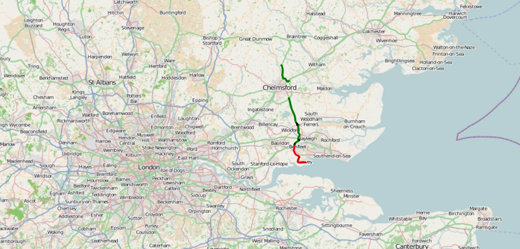
A130 road
The A130 is a major road in England linking Little Waltham, near Chelmsford, the county town of Essex, with Canvey Island in the south of that county....
Baddow Park
Baddow Park is a settlement in Essex, England. It is near the A12 road and is 3 kilometres (2 mi) south of the town of Chelmsford. == External links... ==

West Hanningfield
West Hanningfield is a small village and civil parish in south Essex, England. It is located approximately 5 mi (8.0 km) south-south-east of the county...

Howe Green, Chelmsford
Howe Green is a village in the civil parish of Sandon, in the Chelmsford district, in the county, Essex, England. In 2011 it had a population of 666....
Marconi Research Centre
Marconi Research Centre is the former name of the current BAE Systems Applied Intelligence Laboratories facility at Great Baddow in Essex, United Kingdom...

Galleywood
Galleywood is a village surrounded by countryside in Essex; it is situated on the outskirts of the city of Chelmsford, about 30 miles from London. The...
Galleywood Common
Galleywood Common is a 44.6 hectare Local Nature Reserve in Chelmsford in Essex, near the village of Galleywood. It is owned and managed by Chelmsford...

Hanningfield Reservoir
Hanningfield Reservoir is a large 25,500-million-litre (900,000,000 cu ft) pumped storage reservoir located between Billericay and Chelmsford in Essex...
Nearby Amenities
Located within 500m of 51.686996,0.50523889Have you been to Bluebell Wood?
Leave your review of Bluebell Wood below (or comments, questions and feedback).