High Peartree Wood

Wood, Forest in Sussex Rother

England

High Peartree Wood

Gillham Wood Road A view of Gillham Wood Road. A dead end road leading to Gillham Wood Sussex Wildlife Trust Nature Reserve in Cooden, East Sussex.
Gillham Wood Road Credit: John P Reeves

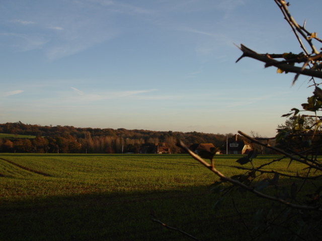
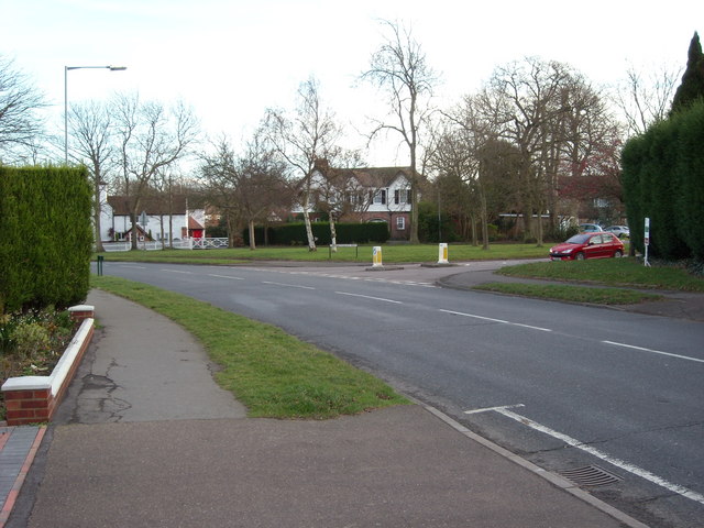
High Peartree Wood is a charming woodland located in Sussex, England. Covering an area of approximately 100 acres, this ancient forest is known for its rich biodiversity and stunning natural beauty. The wood is situated in a rural area, surrounded by picturesque countryside, making it a popular destination for nature enthusiasts and hikers.

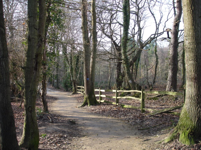
The woodland is primarily composed of native tree species such as oak, ash, and beech, creating a dense and diverse canopy that provides a habitat for a wide range of flora and fauna. The forest floor is adorned with a carpet of wildflowers, including bluebells, primroses, and wood anemones, which bloom in abundance during the spring months, adding to the wood's enchanting atmosphere.

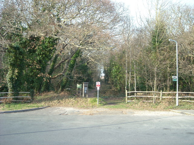
High Peartree Wood is home to a variety of wildlife, including deer, foxes, and numerous bird species such as owls, woodpeckers, and songbirds. Nature lovers can explore the forest's network of well-maintained trails, which wind through the woodland, offering glimpses of hidden glades and tranquil streams.

The wood also boasts a rich history, with evidence of human habitation dating back thousands of years. Archaeological discoveries have revealed traces of ancient settlements and ceremonial sites within its boundaries, adding to its cultural significance.

Visitors to High Peartree Wood can enjoy a peaceful and immersive experience in nature, with opportunities for birdwatching, photography, and simply soaking in the serene ambiance. The forest's accessibility and well-preserved ecosystem make it a cherished gem in the Sussex countryside, attracting both locals and tourists alike.

If you have any feedback on the listing, please let us know in the comments section below.

High Peartree Wood Images

Images are sourced within 2km of 50.85657/0.43359071 or Grid Reference TQ7109. Thanks to Geograph Open Source API. All images are credited.

Gillham Wood Road A view of Gillham Wood Road. A dead end road leading to Gillham Wood Sussex Wildlife Trust Nature Reserve in Cooden, East Sussex.
Gillham Wood Road
A view of Gillham Wood Road. A dead end road leading to Gillham Wood Sussex Wildlife Trust Nature Reserve in Cooden, East Sussex.
Little Common Football Club View of covered stands at the main pitch at Little Common Recreation Ground.
Little Common Football Club
View of covered stands at the main pitch at Little Common Recreation Ground.
Little Common FC Little Common vs Saltdean United in the Southern Combination Premier Division.
Little Common FC
Little Common vs Saltdean United in the Southern Combination Premier Division.
Postbox in Cooden Sea Road, Little Common
Junction of Birkdale and Copse Road, Little Common
Cooden Sea Road, Cooden, Sussex
Fingerpost, Little Common Road, Bexhill, Sussex At junction of Little Common Road and Sutherland Ave (B2098)
Fingerpost, Little Common Road, Bexhill, Sussex
At junction of Little Common Road and Sutherland Ave (B2098)
Cemetery Bexhill-on-Sea East Sussex The Cemetery at Bexhill-on-Sea East Sussex.The sea is in the background behind the trees.
Cemetery Bexhill-on-Sea East Sussex
The Cemetery at Bexhill-on-Sea East Sussex.The sea is in the background behind the trees.
Coneyburrow Lane Nr Little Common Bexhill-on-Sea East Sussex Coneyburrow Lane going towards the A259 from Hooe Nr Bexhill East Sussex
Coneyburrow Lane Nr Little Common Bexhill-on-Sea East Sussex
Coneyburrow Lane going towards the A259 from Hooe Nr Bexhill East Sussex
Footpath from Coneyburrow Lane to Whydown East Sussex Footpath in Coneyburrow Lane across the farmland to Whydown near Hooe, East Sussex.
Footpath from Coneyburrow Lane to Whydown East Sussex
Footpath in Coneyburrow Lane across the farmland to Whydown near Hooe, East Sussex.
Farmland at Whydown East Sussex Farmland at Whydown from the Whydown Road looking towards High Woods Nr Hooe East Sussex
Farmland at Whydown East Sussex
Farmland at Whydown from the Whydown Road looking towards High Woods Nr Hooe East Sussex
Broad Oak  Park  Bexhill-on-Sea East Sussex Broad Oak Park. Farmland looking towards Highwoods golf course and Turkey Road Bexhill-on-Sea.
Broad Oak Park Bexhill-on-Sea East Sussex
Broad Oak Park. Farmland looking towards Highwoods golf course and Turkey Road Bexhill-on-Sea.
Road Little Common East Sussex Pear Tree Lane heading south into the village of Little Common which is on the A259
Road Little Common East Sussex
Pear Tree Lane heading south into the village of Little Common which is on the A259
High Woods Nr Little Common East Sussex Woodland near Peartree Lane.While we were in this wood we saw a white Squirrel which I took a photo of.
High Woods Nr Little Common East Sussex
Woodland near Peartree Lane.While we were in this wood we saw a white Squirrel which I took a photo of.
Farmland Nr Little Common East Sussex View looking across farmland to Picknill Green from Sandhurst Lane which joins Conneyburrow Lane.
Farmland Nr Little Common East Sussex
View looking across farmland to Picknill Green from Sandhurst Lane which joins Conneyburrow Lane.
Summer Hill Allotments, Bexhill The Summer Hill Allotments are to be found at the north end of Knebworth Road close to the Glenleigh Park area of Bexhill.
Summer Hill Allotments, Bexhill
The Summer Hill Allotments are to be found at the north end of Knebworth Road close to the Glenleigh Park area of Bexhill.
Birkdale Nursery, Bexhill-on-Sea What was obviously a former chapel is now a day nursery.
Birkdale Nursery, Bexhill-on-Sea
What was obviously a former chapel is now a day nursery.
Birkdale, Bexhill-on-Sea This junction marks a 'boundary' between Collington and the posher reaches of west Bexhill.
Birkdale, Bexhill-on-Sea
This junction marks a 'boundary' between Collington and the posher reaches of west Bexhill.
Show me another place!

High Peartree Wood is located at Grid Ref: TQ7109 (Lat: 50.85657, Lng: 0.43359071)

Administrative County: East Sussex

District: Rother

Police Authority: Sussex

What 3 Words

///elect.lorry.drift. Near Bexhill-on-Sea, East Sussex

Related Wikis

High Woods

High Woods is a 33.7-hectare (83-acre) biological Site of Special Scientific Interest on the northern outskirts of Bexhill-on-Sea in East Sussex. It is...
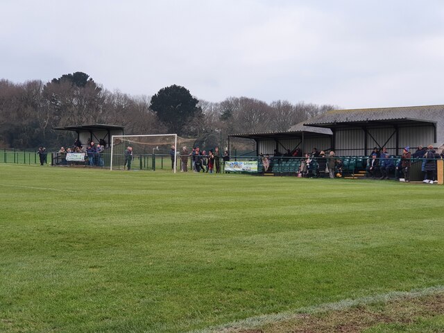
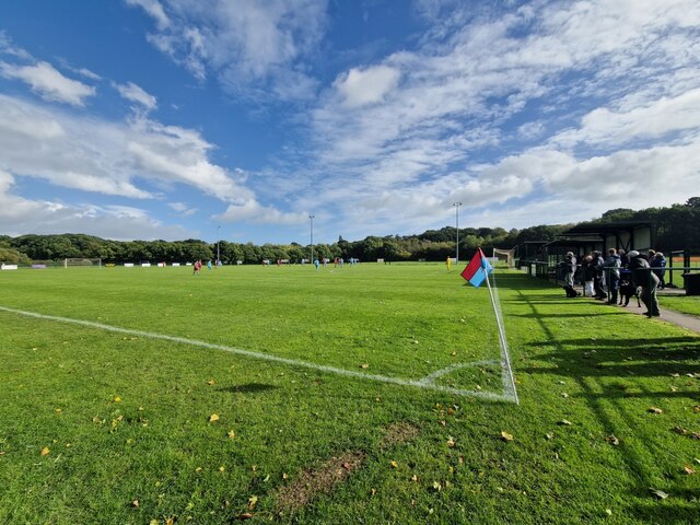
Little Common F.C.

Little Common Football Club is a football club based in the Little Common area of Bexhill-on-Sea, East Sussex, England. They are currently members of the...

Bexhill High Academy

Bexhill High Academy (formerly Bexhill High School) is a coeducational secondary school with academy status, located in Bexhill-on-Sea in the English county...

Beeches Farm

Beeches Farm is a farm and country house in Bexhill, East Sussex, England. A Grade II listed building, it dates to at least the 18th century, and is a...

HM Prison Northeye

H.M. Prison Northeye was a prison located at Bexhill-on-Sea, East Sussex, England which was in operation from 1969 to 1992. The prison was formerly the...

Gillham Wood

Gillham Wood is a 3-hectare (7.4-acre) nature reserve west of Bexhill-on-Sea in East Sussex. It is managed by the Sussex Wildlife Trust.The wood is mainly...

Hooe Common

Hooe Common is a village in the Wealden district of East Sussex. == References ==

Sidley, East Sussex

Sidley is a village on the outskirts of Bexhill-on-Sea in East Sussex, England. Its governance falls within the jurisdiction of the Charter Trustees town...

Nearby Amenities

Located within 500m of 50.85657,0.43359071
Power: pole
Lat/Long: 50.8558726/0.4318168
Power: pole
Lat/Long: 50.8564659/0.4327472
Power: pole
Lat/Long: 50.8558203/0.4319217
Power: pole
Lat/Long: 50.8565194/0.4326337
Post Box
Addr City: Bexhill-on-Sea
Addr Street: Peartree Lane
Collection Times: Mo-Fr 17:00; Sa 07:15
Description: Red pouch box attached
Operator: Royal Mail
Post Box Type: pillar
Ref: TN39 57
Ref GB Uprn: 10015470598
Royal Cypher: EIIR
Royal Cypher Wikidata: Q33102113
Wikimedia Commons: File:PB Peartree Lane TN3957.jpg
Lat/Long: 50.8526852/0.436968
Post Box
Addr City: Bexhill-on-Sea
Addr Street: Whydown Road
Collection Times: Mo-Fr 09:00; Sa 07:00
Operator: Royal Mail
Operator Wikidata: Q638098
Post Box Type: lamp
Ref: TN39 33
Ref GB Uprn: 10015313120
Royal Cypher: EIIR
Royal Cypher Wikidata: Q33102113
Wikimedia Commons: File:PB Whydown Road TN3933.jpg
Lat/Long: 50.8573587/0.4291206
Loc Name: Four Turnings
Lat/Long: 50.8578265/0.4361548
Access: yes
Barrier: stile
Foot: designated
Material: wood
Stile: stepover
Lat/Long: 50.8558416/0.4275992
Barrier: height_restrictor
Maxheight: 2.1
Lat/Long: 50.8596652/0.4363881
Welcome to Highwoods
Addr Place: Highwoods SSSI
Board Type: notice
Information: board
Operator: Highwoods Preservation Society
Tourism: information
Wikimedia Commons: File:Highwoods information board, Bexhill-on-Sea.jpg
Lat/Long: 50.8603251/0.4359341
Addr Place: Highwoods SSSI
Covered: no
Leisure: picnic_table
Wikimedia Commons: File:Picnic area, Highwoods, Bexhill.jpg
Lat/Long: 50.8608133/0.4355216
Power: pole
Lat/Long: 50.8604347/0.4372182
Power: pole
Lat/Long: 50.8609748/0.4342448
Power: pole
Lat/Long: 50.8574254/0.4334185
Power: pole
Lat/Long: 50.8574542/0.4333111
Power: pole
Lat/Long: 50.8583647/0.4340758
Power: pole
Lat/Long: 50.8583956/0.4339668
Power: pole
Lat/Long: 50.8592062/0.4346806
Power: pole
Lat/Long: 50.8592378/0.4345629
Power: pole
Lat/Long: 50.8601652/0.4353538
Power: pole
Lat/Long: 50.860206/0.4352382
Power: pole
Lat/Long: 50.8607919/0.4357958
Power: pole
Lat/Long: 50.8608313/0.4356786
Power: pole
Lat/Long: 50.8579268/0.4287605
Power: pole
Lat/Long: 50.8590628/0.4292031
Power: pole
Lat/Long: 50.8600101/0.4295531
Power: pole
Lat/Long: 50.8599195/0.4371692
Dragonflies & Damselflies
Addr Place: Highwoods SSSI
Board Type: wildlife
Description: Insect life around ponds and woods.
Information: board
Operator: Highwoods Preservation Society
Tourism: information
Wikimedia Commons: File:Dragonflies & Damselflies Information Board, Highwoods, Bexhill-on-Sea.jpg
Lat/Long: 50.8597942/0.4342765
Bench
Backrest: no
Colour: brown
Material: wood
Seats: 2
Lat/Long: 50.8600465/0.434133
Bench
Backrest: no
Colour: brown
Material: wood
Seats: 2
Lat/Long: 50.861004/0.433917
Bench
Backrest: no
Colour: brown
Material: wood
Seats: 2
Lat/Long: 50.8597816/0.4343783
Bench
Backrest: no
Colour: brown
Material: wood
Seats: 2
Lat/Long: 50.8592973/0.4335147
Bench
Backrest: no
Colour: brown
Material: wood
Seats: 2
Lat/Long: 50.8586624/0.4343542
Bench
Backrest: no
Colour: brown
Material: wood
Seats: 2
Lat/Long: 50.8591094/0.4347566
Bench
Backrest: no
Colour: brown
Material: wood
Seats: 2
Lat/Long: 50.8606442/0.4359448
Welcome to Highwoods
Addr Place: Highwoods SSSI
Board Type: notice
Information: board
Operator: Highwoods Preservation Society
Tourism: information
Wikimedia Commons: File:Highwoods information board, Bexhill-on-Sea.jpg
Lat/Long: 50.860617/0.4358617
Waste Basket
Lat/Long: 50.8604021/0.4360118
Power: pole
Lat/Long: 50.8537263/0.4290858
Power: pole
Lat/Long: 50.8537871/0.4289888
Power: pole
Lat/Long: 50.8547679/0.4304334
Power: pole
Lat/Long: 50.85482/0.4303389
Man Made: flagpole
Lat/Long: 50.8566395/0.4272551
Fountain
Lat/Long: 50.8566577/0.4272732
Power: pole
Lat/Long: 50.8542527/0.429704
Power: pole
Lat/Long: 50.8543063/0.429606
Power: pole
Lat/Long: 50.8553387/0.4312448
Power: pole
Lat/Long: 50.8553982/0.4311527
Watering Place
Lat/Long: 50.8604351/0.4360655
Golf: pin
Ref: 15
Lat/Long: 50.8553379/0.4397093
Golf: tee
Ref: 14
Tee: red
Lat/Long: 50.8555978/0.4400405
Golf: tee
Ref: 14
Tee: yellow
Lat/Long: 50.8555792/0.4395819
Golf: tee
Ref: 14
Tee: white
Lat/Long: 50.8555436/0.4394183
Golf: pin
Ref: 13
Lat/Long: 50.8554115/0.4389462
Golf: tee
Ref: 8
Tee: yellow
Lat/Long: 50.8566064/0.4393359
Golf: tee
Ref: 8
Tee: white
Lat/Long: 50.8566652/0.4391242
Golf: tee
Ref: 8
Tee: red
Lat/Long: 50.8565492/0.4395418
Golf: pin
Ref: 7
Lat/Long: 50.8563377/0.4391889
Golf: tee
Ref: 7
Tee: white
Lat/Long: 50.8555233/0.4380798
Golf: tee
Ref: 7
Tee: yellow
Lat/Long: 50.8556181/0.4381737
Golf: tee
Ref: 7
Tee: red
Lat/Long: 50.8556892/0.4381791
Golf: pin
Ref: 6
Lat/Long: 50.8553421/0.4383025
Golf: pin
Ref: 3
Lat/Long: 50.8534304/0.4379725
Golf: tee
Ref: 3
Tee: white
Lat/Long: 50.8564376/0.4382582
Golf: tee
Ref: 3
Tee: yellow
Lat/Long: 50.8563597/0.4381375
Golf: tee
Ref: 3
Tee: red
Lat/Long: 50.8562785/0.4380289
Golf: pin
Ref: 2
Lat/Long: 50.856888/0.4395175
Addr Street: Peartree Lane
Barrier: tank_trap
Description: 14 concrete tank-trap from WWII, both sides of road. The Home Guard Sidley platoon manned a roadblock here with a weapon pit stocked with Molotov Cocktails and sticky bombs.
Historic: barrier
Military: barrier
Start Date: c1940
Tank Trap: dragons_teeth
Wikimedia Commons: File:World War 2 Anti-tank Cubes, Peartree Lane, Bexhill.jpg
Wikimedia Commons 1: File:World War 2 Anti-tank Cubes, Peartree Lane, Bexhill (2).jpg
Lat/Long: 50.8574417/0.4359153
Addr Place: Highwoods SSSI
Covered: no
Leisure: picnic_table
Lat/Long: 50.8596643/0.4341444
Addr Place: Highwoods SSSI
Covered: no
Leisure: picnic_table
Lat/Long: 50.8596723/0.4349121
Give Way
Direction: backward
Lat/Long: 50.8578625/0.436209
Give Way
Direction: forward
Lat/Long: 50.8577779/0.4360823
Access: yes
Barrier: cycle_barrier
Lat/Long: 50.85407/0.4360888
The data included in this document is from www.openstreetmap.org. The data is made available under ODbL.

Have you been to High Peartree Wood?

Leave your review of High Peartree Wood below (or comments, questions and feedback).