Barnfield Wood

Wood, Forest in Sussex Rother

England

Barnfield Wood

Jack Fuller's Inn This Inn, in the hamlet of Oxley's Green near Brightling, is named after the eccentric MP for Eastbourne, Mad Jack Fuller. He built numerous follies in the area and also the Belle Tout lighthouse near Birling Gap.
Jack Fuller's Inn Credit: Geoff Ayres

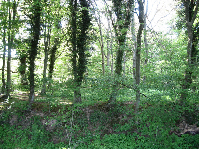
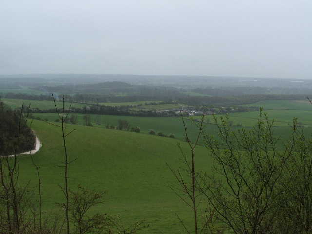
Barnfield Wood is a picturesque woodland located in Sussex, England. Covering an area of approximately 50 acres, it is a popular destination for nature enthusiasts and locals alike.

The wood is predominantly composed of broad-leaved trees, with a diverse range of species including oak, birch, and beech. These trees provide a dense canopy, creating a cool and shaded environment perfect for a leisurely stroll on a hot summer's day. In spring, Barnfield Wood is transformed into a vibrant display of wildflowers, with bluebells carpeting the forest floor.

The wood is home to a wide variety of wildlife, making it a haven for nature lovers. Visitors may spot small mammals such as squirrels and rabbits, along with a plethora of bird species including woodpeckers, thrushes, and warblers. Additionally, the wood provides a habitat for a range of insects and butterflies, adding to its biodiversity.

For those interested in history, Barnfield Wood holds cultural significance as it was once part of the medieval Wealden Forest, an important hunting ground for the Norman kings. Today, visitors can still find remnants of ancient boundary banks and ditches, offering a glimpse into the area's past.

With its tranquil atmosphere and natural beauty, Barnfield Wood offers a wonderful escape from the hustle and bustle of everyday life. Whether you are seeking a peaceful walk, a chance to observe wildlife, or a glimpse into history, this woodland is sure to captivate visitors of all ages.

If you have any feedback on the listing, please let us know in the comments section below.

Barnfield Wood Images

Images are sourced within 2km of 50.980722/0.42721267 or Grid Reference TQ7022. Thanks to Geograph Open Source API. All images are credited.

Jack Fuller's Inn This Inn, in the hamlet of Oxley's Green near Brightling, is named after the eccentric MP for Eastbourne, Mad Jack Fuller. He built numerous follies in the area and also the Belle Tout lighthouse near Birling Gap.
Jack Fuller's Inn
This Inn, in the hamlet of Oxley's Green near Brightling, is named after the eccentric MP for Eastbourne, Mad Jack Fuller. He built numerous follies in the area and also the Belle Tout lighthouse near Birling Gap.
Across the bean field To buildings at Fonthill Farm. Broad beans are harvested as an animal feed crop.
Across the bean field
To buildings at Fonthill Farm. Broad beans are harvested as an animal feed crop.
Bridleway off Fontridge Lane This lane leads to some fantastically named places; Grandturzel, Glydwish Wood, and Toad Cottage.
Bridleway off Fontridge Lane
This lane leads to some fantastically named places; Grandturzel, Glydwish Wood, and Toad Cottage.
Grandturzel and Little Grandturzel Two isolated properties in the valley south of Etchingham.
Grandturzel and Little Grandturzel
Two isolated properties in the valley south of Etchingham.
Hay field and woodland north of Oxley's Green Wealden mix of field and woods.
Hay field and woodland north of Oxley's Green
Wealden mix of field and woods.
Jack Fuller's Located at Oxley Green, just outside Brightling village on the road to Robertsbridge, is a building that was once a pub called The Fullers Arms. Legend has it that in order to gain permission to erect his pyramid mausoleum in the churchyard, the vicar of Brightling asked that Jack Fuller move the local pub to a new location. The Green Man,  then across the street from the church, was moved to the new site, half a mile down the road. Local lore explains that the vicar was disconcerted because too many village folk, including the bell ringers,  were spending part of their Sunday at the pub.
In recent years it was a restaurant called Jack Fuller's. The property was sold and re-opened as a pub in the spring of 2002. It is now a private home.
Jack Fuller's
Located at Oxley Green, just outside Brightling village on the road to Robertsbridge, is a building that was once a pub called The Fullers Arms. Legend has it that in order to gain permission to erect his pyramid mausoleum in the churchyard, the vicar of Brightling asked that Jack Fuller move the local pub to a new location. The Green Man, then across the street from the church, was moved to the new site, half a mile down the road. Local lore explains that the vicar was disconcerted because too many village folk, including the bell ringers, were spending part of their Sunday at the pub. In recent years it was a restaurant called Jack Fuller's. The property was sold and re-opened as a pub in the spring of 2002. It is now a private home.
The Oast, Brightling Place, Brightling, East Sussex
Oast House at Manor Farm, Brightling Road, Oxley Green, East Sussex Single round kiln oast house. A horse and carriage icon to vane.
Oast House at Manor Farm, Brightling Road, Oxley Green, East Sussex
Single round kiln oast house. A horse and carriage icon to vane.
Oast House at Manor Farm, Brightling Road, Oxley Green, East Sussex Single round kiln oast house. A horse and carriage icon to vane.
Oast House at Manor Farm, Brightling Road, Oxley Green, East Sussex
Single round kiln oast house. A horse and carriage icon to vane.
Fontridge Lane
Fontridge Lane
House on Fontridge Lane
Oast House at Grandturzel Farm, Fontridge Lane, Burwash, East Sussex
Grandturzel Farm, Fontridge Lane, Burwash, East Sussex Built c1820.

Grade II listed.
Grandturzel Farm, Fontridge Lane, Burwash, East Sussex
Built c1820. Grade II listed.
Oast House at Browns Oak Farm, Brick Yard Lane, Burwash, East Sussex Internal kilned oast house.
Oast House at Browns Oak Farm, Brick Yard Lane, Burwash, East Sussex
Internal kilned oast house.
Drusilla's Oast, Fontridge Lane, Etchingham, East Sussex Single internal kilned oast house. Now known as Drusilla's Oast.
Drusilla's Oast, Fontridge Lane, Etchingham, East Sussex
Single internal kilned oast house. Now known as Drusilla's Oast.
Stable at Old Brick Farm
Lane through the woods This lane has just crossed the headwaters of the infant River Rother and is going uphill on its way to Oxley's Green. Little Hoaths Wood is to the right and Great Hoaths Wood is to the left.
Lane through the woods
This lane has just crossed the headwaters of the infant River Rother and is going uphill on its way to Oxley's Green. Little Hoaths Wood is to the right and Great Hoaths Wood is to the left.
Bridge over the River Rother This lane has just crossed the headwaters of the infant River Rother and is going uphill on its way to Fontridge Lane. The edge of Little Hoaths Wood is to the left and the edge of Great Hoaths Wood is to the right.

The source of the River Rother is not far from here and it eventually flows into the English Channel at Rye Bay. See <span class="nowrap"><a title="https://en.wikipedia.org/wiki/River_Rother,_East_Sussex" rel="nofollow ugc noopener" href="https://en.wikipedia.org/wiki/River_Rother,_East_Sussex">Link</a><img style="margin-left:2px;" alt="External link" title="External link - shift click to open in new window" src="https://s1.geograph.org.uk/img/external.png" width="10" height="10"/></span>   for more information on the Rother.
Bridge over the River Rother
This lane has just crossed the headwaters of the infant River Rother and is going uphill on its way to Fontridge Lane. The edge of Little Hoaths Wood is to the left and the edge of Great Hoaths Wood is to the right. The source of the River Rother is not far from here and it eventually flows into the English Channel at Rye Bay. See LinkExternal link for more information on the Rother.
Show me another place!

Barnfield Wood is located at Grid Ref: TQ7022 (Lat: 50.980722, Lng: 0.42721267)

Administrative County: East Sussex

District: Rother

Police Authority: Sussex

What 3 Words

///dispensed.items.ponies. Near Burwash, East Sussex

Related Wikis

Darwell Reservoir

Darwell Reservoir lies to the west of Mountfield, East Sussex, England. The reservoir provides water for Southern Water customers. The reservoir covers...

Etchingham

Etchingham is a village and civil parish in the Rother district of East Sussex in southern England. The village is located approximately 15 miles (24 km...

Glottenham Castle

Glottenham Castle was a castle in Mountfield, East Sussex, around 5 miles (8 km) north of Battle Abbey. Built in the 13th century, it was abandoned in...

Robertsbridge Community College

Robertsbridge Community College is a coeducational secondary school located in Robertsbridge in the English county of East Sussex.It was established in...

Brightling

Brightling is a village and civil parish in the Rother district of East Sussex, England. It is located on the Weald eight miles (13 km) north-west of Battle...

Weald

The Weald () is an area of South East England between the parallel chalk escarpments of the North and the South Downs. It crosses the counties of Hampshire...

Darwell Wood

Darwell Wood is a 37.5-hectare (93-acre) biological Site of Special Scientific Interest north-west of Battle in East Sussex. == Species == Most of the...

Robertsbridge Junction railway station

Robertsbridge Junction is the terminus of the Rother Valley Railway, the extension of the Kent and East Sussex Railway from Bodiam to Robertsbridge. Because...

Have you been to Barnfield Wood?

Leave your review of Barnfield Wood below (or comments, questions and feedback).