Beech Wood

Wood, Forest in Kent Maidstone

England

Beech Wood

Yalding Station Building
Yalding Station Building Credit: Dave Thompson

Beech Wood, located in Kent, England, is a picturesque forest known for its abundant beech trees. Spanning an area of approximately 500 acres, it forms part of a larger woodland area known as the Kent Downs Area of Outstanding Natural Beauty.

The woodland is characterized by its dense canopy of towering beech trees, which create a tranquil and serene atmosphere. The smooth, silver-grey bark of the beech trees contrasts beautifully with the vibrant green foliage, especially during the spring and summer months. The forest floor is covered in a thick carpet of fallen leaves, adding to the area's natural charm.

Beech Wood is a haven for wildlife, offering a diverse range of habitats for many species. It is home to a variety of birds, including woodpeckers, owls, and warblers, which fill the air with their melodic calls. The forest also provides a habitat for small mammals such as squirrels, hedgehogs, and foxes.

The wood is a popular destination for nature lovers, hikers, and photographers who visit to immerse themselves in the natural beauty and tranquility it offers. Walking trails wind through the forest, allowing visitors to explore its hidden corners and discover its unique flora and fauna.

Beech Wood, Kent, offers a peaceful retreat from the hustle and bustle of everyday life, providing a chance to connect with nature and experience the beauty of a well-preserved woodland ecosystem.

If you have any feedback on the listing, please let us know in the comments section below.

Beech Wood Images

Images are sourced within 2km of 51.228018/0.39254922 or Grid Reference TQ6750. Thanks to Geograph Open Source API. All images are credited.

Yalding Station Building
Yalding Station building and footbridge
Yalding Station looking North
Yalding Station looking South
Canal beside Hampstead Lane When drained it is surprising how shallow it is.
Canal beside Hampstead Lane
When drained it is surprising how shallow it is.
Hampstead Lock
Hampstead Lock
Stanford Lane, near Hadlow
Bells Farm Road, near East Peckham
Fingerpost, near East Peckham At the junction of Bells farm Lane, Bullen Lane and Martins Lane.
Fingerpost, near East Peckham
At the junction of Bells farm Lane, Bullen Lane and Martins Lane.
Martins Lane, near East Peckham
Old Church Lane This is just off the very busy race track of the A228. It leads ahead up the hill to the isolated St Michael's Church at East Peckham - see <a title="https://www.geograph.org.uk/photo/3025307" href="https://www.geograph.org.uk/photo/3025307">Link</a>
Old Church Lane
This is just off the very busy race track of the A228. It leads ahead up the hill to the isolated St Michael's Church at East Peckham - see Link
The bottom of Old Church Lane The very busy race track of the A228 is just around the bend ahead. Old Church Lane leads down the hill from the isolated St Michael's Church at East Peckham - see <a title="https://www.geograph.org.uk/photo/3025307" href="https://www.geograph.org.uk/photo/3025307">Link</a>
The bottom of Old Church Lane
The very busy race track of the A228 is just around the bend ahead. Old Church Lane leads down the hill from the isolated St Michael's Church at East Peckham - see Link
Road junction near Crowhurst Hop Farm Bells Farm Road is to the left and Martins Lane to the right, while Bullen Lane is behind. Crowhurst Hop Farm is beyond the hedge on the right.
Road junction near Crowhurst Hop Farm
Bells Farm Road is to the left and Martins Lane to the right, while Bullen Lane is behind. Crowhurst Hop Farm is beyond the hedge on the right.
Triangular green at a road junction near Crowhurst Hop Farm Bells Farm Road is to the left and Martins Lane to the right, while Bullen Lane is behind. Crowhurst Hop Farm is beyond the hedge on the right.
Triangular green at a road junction near Crowhurst Hop Farm
Bells Farm Road is to the left and Martins Lane to the right, while Bullen Lane is behind. Crowhurst Hop Farm is beyond the hedge on the right.
Show me another place!

Beech Wood is located at Grid Ref: TQ6750 (Lat: 51.228018, Lng: 0.39254922)

Administrative County: Kent

District: Maidstone

Police Authority: Kent

What 3 Words

///claps.motels.chuckling. Near East Peckham, Kent

Related Wikis

Nettlestead Green

Nettlestead Green, like its near neighbour Nettlestead, lies in the Medway valley southwest of Maidstone in Kent. It has a church and a 17th-century pub...

East Peckham

East Peckham is a village and civil parish in Kent, England on the River Medway. The parish covers the main village as well as Hale Street and Beltring...

Yalding railway station

Yalding railway station is on the Medway Valley Line in Kent, England, serving the village of Yalding. It is 38 miles 19 chains (61.5 km) down the line...

Holy Trinity Church, East Peckham

St Mary's Church is a parish church in East Peckham, Kent. It is a Grade II listed building. == Building == Built of coursed rubble stone with a tiled...
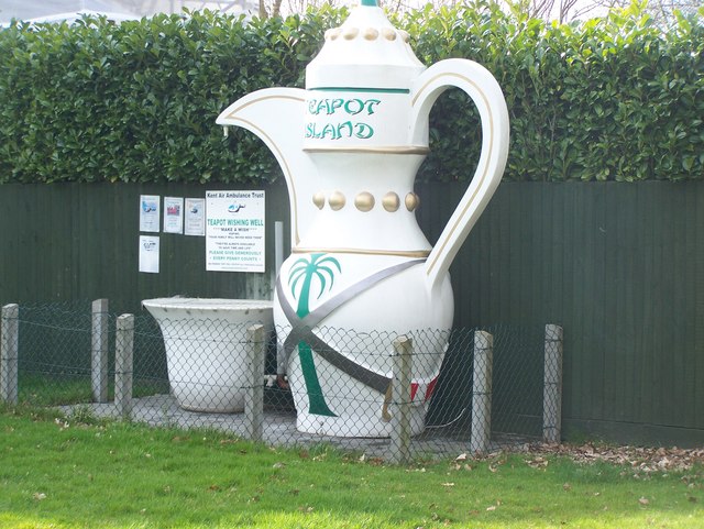
Teapot Island

Teapot Island is a teapot museum in Kent, England. The museum grew from the personal teapot collection of owner Sue Blazye, which started when her grandmother...

St Michael's Church, East Peckham

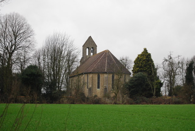
St Michael's is a redundant Anglican church in East Peckham, Kent, England. The church is recorded in the National Heritage List for England as a designated...
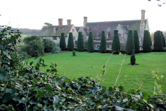
Nettlestead Place

Nettlestead Place is a country house in Nettlestead, Kent, England. The house and its gatehouse are each separately Grade I listed buildings. == Buildings... ==

St Mary's Church, Nettlestead

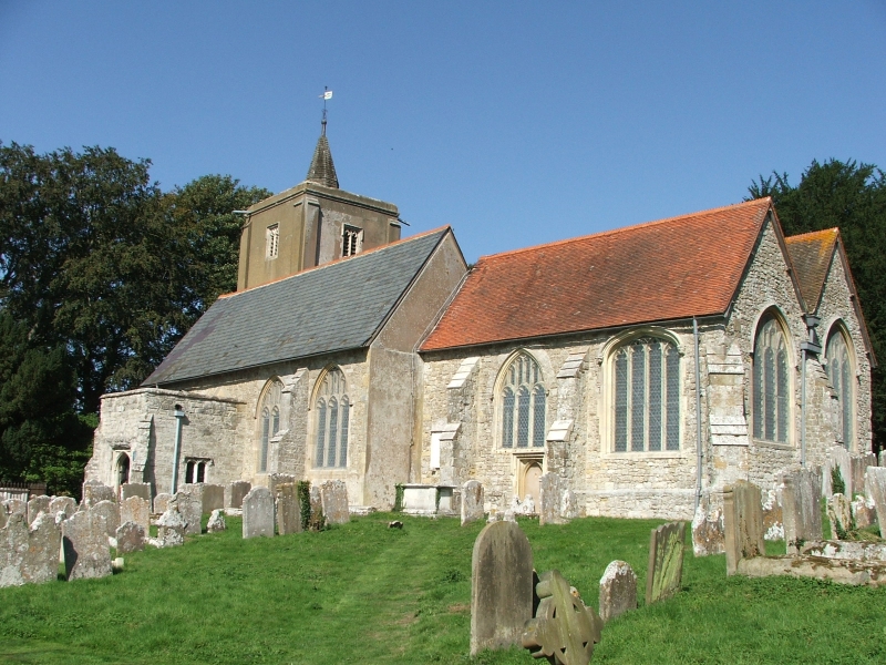
St Mary the Virgin is a parish church in Nettlestead, Kent, begun in the 13th century. == Building == Construction of the church began in the 13th century...

Nearby Amenities

Located within 500m of 51.228018,0.39254922
Barrier: stile
Lat/Long: 51.2241771/0.3962246
Barrier: stile
Lat/Long: 51.2242458/0.3960406
Barrier: stile
Lat/Long: 51.2242347/0.3937861
Barrier: stile
Lat/Long: 51.2244275/0.3917829
Barrier: kissing_gate
Lat/Long: 51.2247002/0.3894441
Barrier: kissing_gate
Lat/Long: 51.2248186/0.3911716
The data included in this document is from www.openstreetmap.org. The data is made available under ODbL.

Have you been to Beech Wood?

Leave your review of Beech Wood below (or comments, questions and feedback).