Fenny Bentley

Settlement in Derbyshire Derbyshire Dales

England

Fenny Bentley

Bridge over Spend Lane north of Ashbourne This carries the Tissington Trail, along the former railway line
Bridge over Spend Lane north of Ashbourne Credit: David Smith

Fenny Bentley is a charming little village located in the Derbyshire Dales district of Derbyshire, England. Situated in the heart of the Peak District National Park, this picturesque village is surrounded by breathtaking natural beauty and offers a peaceful and idyllic setting.

The village is known for its quaint stone cottages and traditional architecture, which adds to its charm and character. Fenny Bentley is home to a close-knit community of friendly residents who take great pride in their village and its heritage.

One of the notable landmarks in Fenny Bentley is the beautiful St. Edmund's Church, a Grade II listed building that dates back to the 12th century. The church showcases stunning stained glass windows and intricate stonework, making it a must-visit for history and architecture enthusiasts.

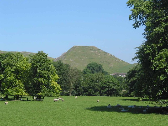
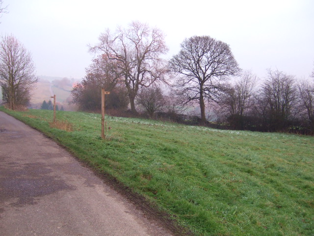
Nature lovers are in for a treat in Fenny Bentley, as the village is surrounded by rolling hills, lush meadows, and picturesque walking trails. The nearby Dovedale is a popular destination for hikers and nature enthusiasts, offering breathtaking views of limestone cliffs and the River Dove.

Despite its tranquil atmosphere, Fenny Bentley is conveniently located close to the market town of Ashbourne, which is just a short drive away. Ashbourne offers a range of amenities including shops, restaurants, and pubs, ensuring residents have access to everything they need.

In conclusion, Fenny Bentley is a delightful village nestled in the heart of the Peak District National Park. With its stunning natural surroundings, historic landmarks, and strong sense of community, it is a truly special place to visit or call home.

If you have any feedback on the listing, please let us know in the comments section below.

Fenny Bentley Images

Images are sourced within 2km of 53.0446/-1.736445 or Grid Reference SK1749. Thanks to Geograph Open Source API. All images are credited.

Bridge over Spend Lane north of Ashbourne This carries the Tissington Trail, along the former railway line
Bridge over Spend Lane north of Ashbourne
This carries the Tissington Trail, along the former railway line
Spend Lane west of Sandybrook Hall Crossing the shallow valley of a small stream
Spend Lane west of Sandybrook Hall
Crossing the shallow valley of a small stream
Misty morning A misty view over fields at Thorpe.
Misty morning
A misty view over fields at Thorpe.
Fields beside the Tissington Trail Early morning mist still hanging in the valley.
Fields beside the Tissington Trail
Early morning mist still hanging in the valley.
Tissington Trail footbridge Crossing the A515 on the old railway line heading to Tissington Village.
Tissington Trail footbridge
Crossing the A515 on the old railway line heading to Tissington Village.
Picnic tables by the Tissington Trail At the Thorpe station cat park.
Picnic tables by the Tissington Trail
At the Thorpe station cat park.
Bridge over Tissington Trail
Tissington Trail South of Tissington Station.
Tissington Trail
South of Tissington Station.
Coach and Horses, Fenny Bentley Pub <span class="nowrap"><a title="https://www.coachandhorsesfennybentley.co.uk/" rel="nofollow ugc noopener" href="https://www.coachandhorsesfennybentley.co.uk/">Link</a><img style="margin-left:2px;" alt="External link" title="External link - shift click to open in new window" src="https://s1.geograph.org.uk/img/external.png" width="10" height="10"/></span> on the eastern side of the A515 to the south of the village
Coach and Horses, Fenny Bentley
Pub LinkExternal link on the eastern side of the A515 to the south of the village
Spend Lane, Thorpe Illuminated by a burst of winter afternoon sunshine, Spend Lane is very narrow as it heads north from the Old Dog pub. It eventually turns into Gag Lane and emerges on the A515 south of Alsop en le Dale.
Spend Lane, Thorpe
Illuminated by a burst of winter afternoon sunshine, Spend Lane is very narrow as it heads north from the Old Dog pub. It eventually turns into Gag Lane and emerges on the A515 south of Alsop en le Dale.
The Old Dog, Thorpe Until 2012 this pub was called the Dog & Partridge; contemporary reviews suggest it was a rather miserable grimy place. After a two year refurbishment it opened in its new guise and, if this Saturday lunchtime was typical, it is now a thriving establishment. See <a href="https://www.geograph.org.uk/photo/2032714">SK1650 : The Dog & Partridge</a> for a view of it as the Dog & Partridge; note that the rendering has been completely removed.
The Old Dog, Thorpe
Until 2012 this pub was called the Dog & Partridge; contemporary reviews suggest it was a rather miserable grimy place. After a two year refurbishment it opened in its new guise and, if this Saturday lunchtime was typical, it is now a thriving establishment. See SK1650 : The Dog & Partridge for a view of it as the Dog & Partridge; note that the rendering has been completely removed.
Dovedale Garage, Thorpe This is a curious establishment, combining a country garage with a restored and fully working cinema organ. The organ came from the ABC cinema at Derby and regular concerts have been given here since 1999. The fuel prices shown are probably not correct - at the time unleaded petrol was generally available for about £1-55 per litre in urban areas.
Dovedale Garage, Thorpe
This is a curious establishment, combining a country garage with a restored and fully working cinema organ. The organ came from the ABC cinema at Derby and regular concerts have been given here since 1999. The fuel prices shown are probably not correct - at the time unleaded petrol was generally available for about £1-55 per litre in urban areas.
Field at Thorpe This is the field at the rear of the Old Dog pub running alongside Wintercroft Lane. The high ground in the distance is on the far side of the Dove valley with Hazelton Clump visible.
Field at Thorpe
This is the field at the rear of the Old Dog pub running alongside Wintercroft Lane. The high ground in the distance is on the far side of the Dove valley with Hazelton Clump visible.
Descending past The Priory
Landscape above Bentley Brook at Woodeaves Mill
Secluded corner
Secluded corner
Narlows Lane car park On the outskirts of Thorpe village in the south of the Peak District National Park.
Narlows Lane car park
On the outskirts of Thorpe village in the south of the Peak District National Park.
"There's Life in the Old Dog Yet" This is the Dog & Partridge public house which closed in 2012, it was undergoing extensive renovation.
"There's Life in the Old Dog Yet"
This is the Dog & Partridge public house which closed in 2012, it was undergoing extensive renovation.
Show me another place!

Fenny Bentley is located at Grid Ref: SK1749 (Lat: 53.0446, Lng: -1.736445)

Administrative County: Derbyshire

District: Derbyshire Dales

Police Authority: Derbyshire

What 3 Words

///consoled.qualifier.feelers. Near Ashbourne, Derbyshire

Related Wikis

Fenny Bentley

Fenny Bentley is a small village and civil parish located close to Dovedale in the Derbyshire Dales district of Derbyshire, England. The population in...

St Edmund's Church, Fenny Bentley

St Edmund's Church, Fenny Bentley is a Grade II* listed parish church in the Church of England in Fenny Bentley, Derbyshire. == History == The church dates...

Thorpe Cloud railway station

Thorpe Cloud railway station was opened in 1899 between the villages of Thorpe and Fenny Bentley in Derbyshire, south east of Buxton. == History == The...

Woodeaves Canal

The Woodeaves Canal (sometimes hyphenated as Wood-Eaves) was a short, privately owned canal near Ashbourne, Derbyshire, England. It was a short waterway...

Mapleton, Derbyshire

Mapleton, sometimes spelt Mappleton, is a village and a civil parish in the Derbyshire Dales District, in the English county of Derbyshire. It is near...

Okeover, Staffordshire

Okeover is a civil parish in the East Staffordshire district, in the county of Staffordshire, England. It has a small population and no central village...

Thorpe, Derbyshire

Thorpe is a village and civil parish in the English county of Derbyshire; it is on the Derbyshire/Staffordshire border, on the east bank of the River Dove...

Ashbourne Green

Ashbourne Green is an area of Derbyshire, England. It is located in the Peak District, 1 mile north-east of Ashbourne in the Offcote and Underwood parish...

Nearby Amenities

Located within 500m of 53.0446,-1.736445
Fenny Bentley
Place: village
Source: local_knowledge
Wikidata: Q4007961
Lat/Long: 53.0478128/-1.7403248
Pub
Bentley Brook Inn
Addr City: Ashbourne
Addr Postcode: DE6 1LF
Addr Street: Bradbourne Road
Addr Village: Fenny Bentley
Beer Garden: yes
Car Park: yes
Fhrs Id: 1626306
Food: yes
Opening Hours Food: All Day
Outdoor Seating: yes
Real Ale: Marston's Pedigree, 1 or 2 other local beers
Source Opening Hours Food: Sign
Website: https://www.bentleybrookinn.co.uk/
Lat/Long: 53.0443151/-1.7370723
Post Box
Brand: Royal Mail
Brand Wikidata: Q638098
Brand Wikipedia: en:Royal Mail
Mapillary: 544409940219781
Operator: Royal Mail
Operator Wikidata: Q638098
Post Box Mounting: pier
Post Box Type: lamp
Ref: DE6 889
Survey Date: 2021-07-17
Lat/Long: 53.0421367/-1.7366747
Ele: 140.4774170
Lat/Long: 53.0472863/-1.7417265
Ele: 140.9580078
Lat/Long: 53.0476699/-1.7412458
Pub
Coach and Horses
Addr City: Ashbourne
Addr County: Derbyshire
Addr Postcode: DE6 1LB
Addr Street: Ashbourne Road
Addr Village: Fenny Bentley
Description Floor: stone
Ele: 133.7480469
Fhrs Id: 1626926
Food: yes
Real Ale: Pedigree, Abbeydale Moonshine (varies)
Source Addr: FHRS Open Data
Lat/Long: 53.0473325/-1.7393275
Bus Stop
Bus: yes
Ele: 133.9884033
Public Transport: platform
Lat/Long: 53.0475582/-1.7394347
Ele: 153.6953125
Lat/Long: 53.0466863/-1.7333602
Barrier: stile
Material: stone
Source: survey;gps
Stile: squeezer
Lat/Long: 53.0431248/-1.7407256
Millfields Bed and Breakfast
Source: survey
Tourism: guest_house
Website: http://www.millfieldsbandb.co.uk/
Lat/Long: 53.0420942/-1.7368379
Bench
Lat/Long: 53.04781/-1.7405161
Bench
Lat/Long: 53.0476933/-1.7400507
Ele: 130.0000000
Lat/Long: 53.04783/-1.7406332
Ele: 130.0000000
Lat/Long: 53.0477124/-1.7402729
Ele: 128.0000000
Lat/Long: 53.0476823/-1.7400646
Ele: 132.0000000
Lat/Long: 53.0479901/-1.741067
Ele: 140.0000000
Lat/Long: 53.0439643/-1.7373652
Ele: 140.0000000
Lat/Long: 53.0439627/-1.7373498
Ele: 141.0000000
Lat/Long: 53.0439577/-1.7373239
Ele: 141.0000000
Lat/Long: 53.0439535/-1.7373007
Ele: 145.0000000
Lat/Long: 53.0439946/-1.7371933
Ele: 155.0000000
Lat/Long: 53.0446619/-1.7362104
Barrier: cattle_grid
Ele: 158.0000000
Lat/Long: 53.0446971/-1.7359685
Fixme: gate or stile?
Lat/Long: 53.0453465/-1.7428133
Barrier: kissing_gate
Lat/Long: 53.0447817/-1.7364303
Barrier: stile
Material: stone
Source: survey
Stile: squeezer
Lat/Long: 53.0479828/-1.7410085
Barrier: stile
Material: stone
Source: survey;gps
Stile: squeezer
Lat/Long: 53.0468526/-1.7425822
Barrier: kissing_gate
Source: survey;gps
Lat/Long: 53.0463785/-1.7398611
Barrier: stile
Ele: 140.7176514
Material: stone
Source: survey
Stile: squeezer
Lat/Long: 53.0476298/-1.7413156
Historic: milestone
Source: NLS - OS 1:25k 1st Series 1937-61
Lat/Long: 53.0439439/-1.7377086
Barrier: stile
Fixme: location of stile reletive to field boundary needs survey. Previously path drawn on south side of fence but it is on the North side at the East End with a marked PROW gate in the hedge
Source: personal observation
Lat/Long: 53.0418398/-1.7363396
The data included in this document is from www.openstreetmap.org. The data is made available under ODbL.

Have you been to Fenny Bentley?

Leave your review of Fenny Bentley below (or comments, questions and feedback).