Graces Wood

Wood, Forest in Essex Uttlesford

England

Graces Wood

TESCO Great Dunmow
TESCO Great Dunmow Credit: Andrew Tatlow

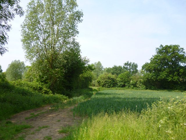
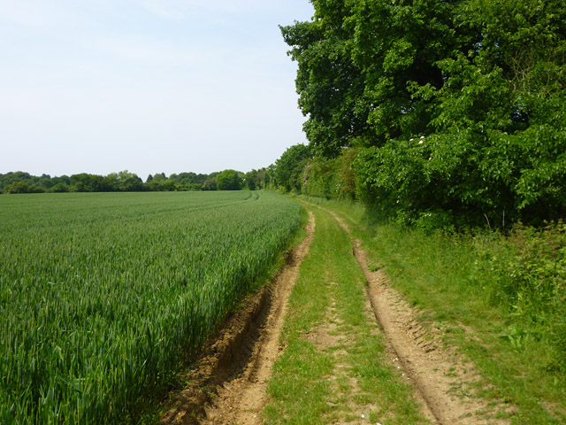
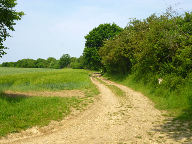
Graces Wood, located in Essex, England, is a picturesque forest area known for its natural beauty and diverse wildlife. Spanning approximately 200 acres, this woodland is a popular destination for nature enthusiasts and outdoor recreation enthusiasts alike.

The forest is characterized by a mix of deciduous and coniferous trees, creating a vibrant and lush environment year-round. Visitors can expect to see a variety of tree species, including oak, beech, pine, and birch. These trees provide a stunning backdrop and create a peaceful atmosphere for visitors to enjoy.

Graces Wood is home to a wide range of wildlife, making it an ideal spot for nature lovers and birdwatchers. Throughout the forest, visitors may catch glimpses of deer, squirrels, foxes, and a variety of bird species, including woodpeckers and owls. The forest's diverse ecosystem supports these animals and provides them with a natural habitat to thrive.

Nature trails and walking paths wind through Graces Wood, offering visitors a chance to explore the area at their own pace. These trails are well-maintained and provide an opportunity to immerse oneself in the tranquility of the forest. Additionally, picnic areas and benches are available, allowing visitors to relax and enjoy the surroundings.

Graces Wood is easily accessible, with ample parking and nearby facilities. Whether visitors are seeking a peaceful stroll, a family picnic, or an opportunity to connect with nature, this woodland in Essex provides a serene and captivating experience for all.

If you have any feedback on the listing, please let us know in the comments section below.

Graces Wood Images

Images are sourced within 2km of 51.886013/0.35411256 or Grid Reference TL6223. Thanks to Geograph Open Source API. All images are credited.

TESCO Great Dunmow
TESCO Great Dunmow
TESCO car park Great Dunmow
New houses, Great Dunmow The recent residential enlargement of Great Dunmow to the north-west spreads further north.
New houses, Great Dunmow
The recent residential enlargement of Great Dunmow to the north-west spreads further north.
Church Row, Little Easton Grade II listed former almshouses, built 1895. The date and a 'W' are placed centrally. The 'W' perhaps stands for Warwick, as apparently Frances, the Countess of Warwick, had them built.
Church Row, Little Easton
Grade II listed former almshouses, built 1895. The date and a 'W' are placed centrally. The 'W' perhaps stands for Warwick, as apparently Frances, the Countess of Warwick, had them built.
Quarry area on site of RAF Great Dunmow 'Quarry' was what the warning notice called it, but there is little sign here apart from the wide and shallow trench between earth banks. In the distance beyond the dead tree are more quarry-like features.
Quarry area on site of RAF Great Dunmow
'Quarry' was what the warning notice called it, but there is little sign here apart from the wide and shallow trench between earth banks. In the distance beyond the dead tree are more quarry-like features.
Mawbyns, Duck Street, Little Easton A 16th century timber framed house, with several alterations over the years. Grade II listed.
Mawbyns, Duck Street, Little Easton
A 16th century timber framed house, with several alterations over the years. Grade II listed.
Field by the B184 It looks like wheat growing.
Field by the B184
It looks like wheat growing.
Field edge track and public footpath Heading towards Bigods Hall Farm.
Field edge track and public footpath
Heading towards Bigods Hall Farm.
Private track to Bigod's Wood The half-hidden sign on the right advises that it is private and firearms are in use.
Private track to Bigod's Wood
The half-hidden sign on the right advises that it is private and firearms are in use.
Frosty lane, Great Dunmow
Pump, High Street, Great Dunmow
Resting on thin ice, or taking a cold bath!
Rosemary Lane, Great Dunmow
New Street at the junction of Great Dunmow High Street
Houses on High Street, Great Dunmow
Houses on The Downs, Great Dunmow
Rosemary Close, Great Dunmow
Show me another place!

Graces Wood is located at Grid Ref: TL6223 (Lat: 51.886013, Lng: 0.35411256)

Administrative County: Essex

District: Uttlesford

Police Authority: Essex

What 3 Words

///corporate.decimal.raven. Near Great Dunmow, Essex

Nearby Locations

Graces Wood

Related Wikis

Helena Romanes School

Helena Romanes School (also known/abbreviated as HRS) is a coeducational all-through school and sixth form. It is situated in Great Dunmow in the English...

Talliston House

Talliston House & Gardens is an ex-council house in Essex, England that has been transformed by owner John Trevillian into a miniature palace. The house...

Little Easton

Little Easton is a village and civil parish in Essex, England. The village is situated approximately 7 miles (11 km) east from the town of Bishop's Stortford...

Great Dunmow

Great Dunmow is a historic market town and civil parish in the Uttlesford district of Essex, England. It is situated on the north of the A120 road, approximately...

Old Town Hall, Great Dunmow

The Old Town Hall is a municipal building in the Market Place, Great Dunmow, Essex, England. The structure, which is now used as the offices of a firm...

Church End Mill, Great Dunmow

Church End Mill is a grade II listed Tower mill at Great Dunmow, Essex, England which has been converted to residential use. == History == Church End Mill...

Stane Street (Colchester)

Stane Street is a 39 mi (63 km) Roman road that runs from Ermine Street at Braughing, Hertfordshire to Colchester in Essex. == Route == Stane Street can...

Dunmow railway station

Dunmow railway station was a station serving Great Dunmow, Essex. The station was 9 miles 38 chains (15.25 km) from Bishop's Stortford on the Bishop's...

Nearby Amenities

Located within 500m of 51.886013,0.35411256
Bus Stop
Helena Romanes School
Bus: yes
Naptan AtcoCode: 1500HRSCHOOL
Naptan CommonName: Helena Romanes School
Naptan Indicator: Forecourt
Naptan Landmark: Helena Romanes School
Naptan NaptanCode: esxjdwgw
Naptan Street: Beaumont Hill
Naptan Verified: no
Public Transport: platform
Source: naptan_import
Lat/Long: 51.8820187/0.3546268
Leisure: swimming_pool
Lat/Long: 51.8816171/0.352796
Power: pole
Lat/Long: 51.8873072/0.3606538
Power: pole
Lat/Long: 51.8877363/0.3572059
Line Management: transition
Power: pole
Lat/Long: 51.8881062/0.3544232
Power: pole
Lat/Long: 51.8875437/0.3589531
Power: pole
Lat/Long: 51.8880048/0.355441
Line Management: transition
Power: pole
Lat/Long: 51.888183/0.3543398
Power: pole
Lat/Long: 51.8855438/0.3610231
Power: pole
Lat/Long: 51.8847839/0.3607576
Power: pole
Lat/Long: 51.8841686/0.3605238
Building: bunker
Bunker Type: pillbox
Military: bunker
Lat/Long: 51.8841473/0.3605216
Power: pole
Lat/Long: 51.8866134/0.3470087
Power: pole
Lat/Long: 51.8870125/0.3487343
Power: pole
Lat/Long: 51.8874305/0.3504637
Power: pole
Lat/Long: 51.8878409/0.3520856
Line Management: transition
Power: pole
Lat/Long: 51.8880255/0.3529889
Line Management: transition
Power: pole
Lat/Long: 51.8881067/0.35301
Direction: both
Traffic Calming: table
Lat/Long: 51.8854671/0.3501486
Direction: both
Traffic Calming: table
Lat/Long: 51.8857558/0.3518844
Barrier: swing_gate
Lat/Long: 51.8887974/0.3528761
Crossing
Crossing: unmarked
Crossing Island: yes
Crossing Markings: no
Tactile Paving: yes
Lat/Long: 51.8879056/0.3534152
Crossing
Crossing: unmarked
Crossing Island: yes
Crossing Markings: no
Tactile Paving: yes
Lat/Long: 51.8878489/0.3534421
Crossing
Lat/Long: 51.8825819/0.3573292
Direction: both
Traffic Calming: table
Lat/Long: 51.8866463/0.3533759
Barrier: wicket_gate
Lat/Long: 51.8857886/0.3492722
Barrier: cycle_barrier
Lat/Long: 51.8872716/0.3543053
Direction: both
Traffic Calming: table
Lat/Long: 51.8862762/0.3523804
The data included in this document is from www.openstreetmap.org. The data is made available under ODbL.

Have you been to Graces Wood?

Leave your review of Graces Wood below (or comments, questions and feedback).