Broad Belt

Wood, Forest in Cambridgeshire East Cambridgeshire

England

Broad Belt

A crossroads on Brinkley Road Brinkley to the left, Six Mile Bottom and Cambridge to the right, Weston Colville and (not very directly) Balsham straight ahead. The road behind the camera runs to Dullingham.
A crossroads on Brinkley Road Credit: John Sutton

Broad Belt is a small woodland area located in Cambridgeshire, England. Covering an area of approximately 200 acres, it is known for its dense and diverse forest habitat. The woodland is characterized by a mix of deciduous and coniferous trees, including oak, beech, pine, and birch, creating a rich and vibrant ecosystem.

As one explores Broad Belt, they are greeted with a variety of plant life, such as bluebells, ferns, and wildflowers, which thrive in the shaded areas beneath the towering trees. This diverse vegetation provides an ideal habitat for a wide range of wildlife. Visitors may spot various species of birds, including woodpeckers, owls, and songbirds, as well as small mammals like squirrels, rabbits, and foxes.

The woodland is intersected by a network of well-maintained footpaths, allowing visitors to easily navigate through the area and enjoy the peaceful surroundings. These paths lead to secluded areas, where one can find benches and picnic spots, providing the perfect setting for relaxation and contemplation.

Broad Belt is also home to a number of historical sites, including remnants of old stone walls and abandoned farmhouses, offering glimpses into the area's past. These historical features add to the charm and intrigue of the woodland, attracting history enthusiasts and nature lovers alike.

Overall, Broad Belt in Cambridgeshire is a picturesque and serene woodland, offering a tranquil escape from the hustle and bustle of everyday life. With its diverse flora and fauna, well-maintained paths, and historical remnants, it is a haven for nature enthusiasts and a place of exploration and discovery.

If you have any feedback on the listing, please let us know in the comments section below.

Broad Belt Images

Images are sourced within 2km of 52.186953/0.35198446 or Grid Reference TL6056. Thanks to Geograph Open Source API. All images are credited.

A crossroads on Brinkley Road Brinkley to the left, Six Mile Bottom and Cambridge to the right, Weston Colville and (not very directly) Balsham straight ahead. The road behind the camera runs to Dullingham.
A crossroads on Brinkley Road
Brinkley to the left, Six Mile Bottom and Cambridge to the right, Weston Colville and (not very directly) Balsham straight ahead. The road behind the camera runs to Dullingham.
North-west from Westley Waterless Straight on for Westley Bottom.
North-west from Westley Waterless
Straight on for Westley Bottom.
Westley Waterless: water shortage After the drought summer of 2022 the water level looks low in the pond on Church Lane.

For comparison: <a href="https://www.geograph.org.uk/photo/3276200">TL6156 : Westley Waterless: Church Lane and pond</a> (2012).
Westley Waterless: water shortage
After the drought summer of 2022 the water level looks low in the pond on Church Lane. For comparison: TL6156 : Westley Waterless: Church Lane and pond (2012).
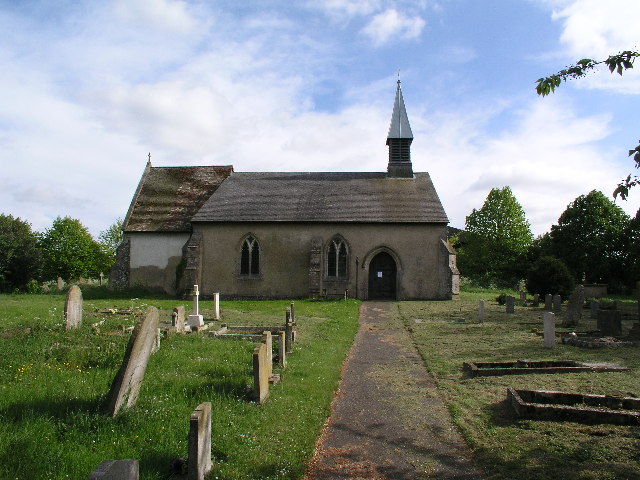
Westley Waterless: St Mary - restoration Two men were working on the bellcote - one on the lead, the other painting the louvres. The spirelet replaced a round tower which collapsed in 1855.

Inside are two exquisite 14th-century brasses: <a href="https://www.geograph.org.uk/photo/3276297">TL6156 : Westley Waterless: brass of Sir John Creke (detail)</a> and <a href="https://www.geograph.org.uk/photo/3276294">TL6156 : Westley Waterless: brass of Lady Creke (detail)</a>.
Westley Waterless: St Mary - restoration
Two men were working on the bellcote - one on the lead, the other painting the louvres. The spirelet replaced a round tower which collapsed in 1855. Inside are two exquisite 14th-century brasses: TL6156 : Westley Waterless: brass of Sir John Creke (detail) and TL6156 : Westley Waterless: brass of Lady Creke (detail).
Westley Waterless: building work A new house on Main Road
Westley Waterless: building work
A new house on Main Road
The eastern edge of Brinkley Wood At over 350ft, the hills of East Cambridgeshire are a lot higher than much of the rest of the county. Big fields and large plantations typify the area.
The eastern edge of Brinkley Wood
At over 350ft, the hills of East Cambridgeshire are a lot higher than much of the rest of the county. Big fields and large plantations typify the area.
Towards Brinkley Wood At over 350ft, the hills of East Cambridgeshire are a lot higher than much of the rest of the county. Big fields and large plantations typify the area. A little further from here, Six Mile Bottom Road, from which this picture was taken, begins to slope down to the lower-lying villages east of Cambridge, near the edge of The Fens.
Towards Brinkley Wood
At over 350ft, the hills of East Cambridgeshire are a lot higher than much of the rest of the county. Big fields and large plantations typify the area. A little further from here, Six Mile Bottom Road, from which this picture was taken, begins to slope down to the lower-lying villages east of Cambridge, near the edge of The Fens.
Dullingham: along Station Road The level crossing is behind the camera. The road leads to the A1304 midway between Six Mile Bottom and Newmarket.
Dullingham: along Station Road
The level crossing is behind the camera. The road leads to the A1304 midway between Six Mile Bottom and Newmarket.
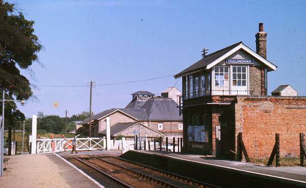
Dullingham Station and level crossing Dullingham is a stop for some Cambridge-Ipswich trains - and a reminder of railways as they used to be as it still has a signal box and traditional hand-operated crossing gates. The signal box is a good example of the Great Eastern Railway type once found all over East Anglia.
Dullingham Station and level crossing
Dullingham is a stop for some Cambridge-Ipswich trains - and a reminder of railways as they used to be as it still has a signal box and traditional hand-operated crossing gates. The signal box is a good example of the Great Eastern Railway type once found all over East Anglia.
Barn near Westley Waterless
Dullingham Station
Dullingham Station
Station Road crossing
St Mary, Westley Waterless
St Mary, Westley Waterless - East end
St Mary, Westley, Waterless
Show me another place!

Broad Belt is located at Grid Ref: TL6056 (Lat: 52.186953, Lng: 0.35198446)

Administrative County: Cambridgeshire

District: East Cambridgeshire

Police Authority: Cambridgeshire

What 3 Words

///visits.skies.pushy. Near Balsham, Cambridgeshire

Related Wikis

Westley Waterless

Westley Waterless is a small village and civil parish in East Cambridgeshire, England, 5 miles south west of Newmarket. == History == The parish of Westley...

Dullingham railway station

Dullingham is a railway station that serves the village of Dullingham in Cambridgeshire, England. It is about 1 mile (1.6 km) north-west of the centre...

Dullingham

Dullingham is a small village and civil parish in East Cambridgeshire, England. It is situated 4 miles (6 km) south of Newmarket and 14 miles (23 km) east...

Six Mile Bottom

Six Mile Bottom is a hamlet within the parish of Little Wilbraham, near Cambridge in England. == Etymology == The hamlet was named in 1801, deriving its...

Nearby Amenities

Located within 500m of 52.186953,0.35198446
Power: pole
Lat/Long: 52.1901058/0.3532166
Power: pole
Lat/Long: 52.1893583/0.348553
Power: pole
Lat/Long: 52.1892993/0.3571519
Power: pole
Lat/Long: 52.1895162/0.3557949
Power: pole
Lat/Long: 52.187207/0.3477523
Power: pole
Lat/Long: 52.1902068/0.3486925
Power: pole
Lat/Long: 52.1882758/0.3481278
Power: pole
Lat/Long: 52.1897334/0.3542875
Power: pole
Lat/Long: 52.1905339/0.3521581
Power: pole
Lat/Long: 52.1909647/0.3510744
The data included in this document is from www.openstreetmap.org. The data is made available under ODbL.

Have you been to Broad Belt?

Leave your review of Broad Belt below (or comments, questions and feedback).