Oak and Ash Plantation

Wood, Forest in Essex

England

Oak and Ash Plantation

Footpath in Mardyke Woods
Footpath in Mardyke Woods Credit: Adrian Benn

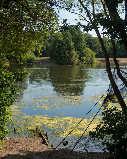
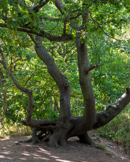
Oak and Ash Plantation is a sprawling woodland located in the picturesque county of Essex, England. Covering an area of approximately 500 acres, this plantation is renowned for its majestic oak and ash trees, which dominate the landscape and provide a haven for a diverse range of flora and fauna.

The woodland is characterized by its dense canopy, creating a cool and serene atmosphere even during the hottest summer days. The oak trees, with their distinctive lobed leaves and sturdy trunks, can reach heights of up to 100 feet, while the ash trees, known for their compound leaves and slender trunks, provide a beautiful contrast to the oaks. These trees are not only aesthetically pleasing but also play an important ecological role, providing nesting sites for birds, shelter for small mammals, and food for various insects.

Walking through Oak and Ash Plantation, visitors can enjoy a network of well-maintained trails that wind their way through the forest, offering breathtaking views of the surrounding countryside. The plantation is also home to a rich variety of wildlife, including deer, foxes, badgers, and a myriad of bird species, making it a popular destination for nature enthusiasts and birdwatchers alike.

In addition to its natural beauty, Oak and Ash Plantation also boasts several amenities for visitors to enjoy. These include picnic areas, designated camping spots, and educational facilities where visitors can learn about the importance of woodland conservation and the history of the area.

Overall, Oak and Ash Plantation offers a tranquil escape from the hustle and bustle of everyday life, providing a serene and awe-inspiring environment for nature lovers and outdoor enthusiasts to explore and appreciate the wonders of the natural world.

If you have any feedback on the listing, please let us know in the comments section below.

Oak and Ash Plantation Images

Images are sourced within 2km of 51.513164/0.27126068 or Grid Reference TQ5781. Thanks to Geograph Open Source API. All images are credited.

Footpath in Mardyke Woods
Flooded Path alongside Mardyke Woods
Tree on one of the ex-gravel pit lakes at Belhus Woods Country Park Sections of Belhus Woods Country Park park were originally part of the Belhus Estate, the grounds of which were designed by Capability Brown; some remnants of which can still be seen.

As well as the areas of grassland and woodland, past gravel extraction on the site has created a series of lakes and clay extraction has created a number of small ponds.

The park includes land owned by Thurrock Council and Essex County Council and is managed by Essex County Council Ranger Service. 

It is situated within Thames Chase Community Forest and borders woodland owned by the Woodland Trust and Forestry Commission.

It is linked to the Oakwood and Ash Plantation by a footbridge <a href="https://www.geograph.org.uk/photo/2651109">TQ5781 : Longpond footbridge</a>.

See <span class="nowrap"><a title="http://www.visitparks.co.uk/placestovisit/belhuscountrypark.php" rel="nofollow ugc noopener" href="http://www.visitparks.co.uk/placestovisit/belhuscountrypark.php">Link</a><img style="margin-left:2px;" alt="External link" title="External link - shift click to open in new window" src="https://s1.geograph.org.uk/img/external.png" width="10" height="10"/></span>
Tree on one of the ex-gravel pit lakes at Belhus Woods Country Park
Sections of Belhus Woods Country Park park were originally part of the Belhus Estate, the grounds of which were designed by Capability Brown; some remnants of which can still be seen. As well as the areas of grassland and woodland, past gravel extraction on the site has created a series of lakes and clay extraction has created a number of small ponds. The park includes land owned by Thurrock Council and Essex County Council and is managed by Essex County Council Ranger Service. It is situated within Thames Chase Community Forest and borders woodland owned by the Woodland Trust and Forestry Commission. It is linked to the Oakwood and Ash Plantation by a footbridge TQ5781 : Longpond footbridge. See LinkExternal link
The A13 at Mar Dyke Interchange, Aveley
Rain on lake in Belhus Woods Country Park Just starting to rain after a long dry period
Rain on lake in Belhus Woods Country Park
Just starting to rain after a long dry period
Angler's view, Belhus Woods Country Park These sections are well used by anglers, as can be seen here with a net leaning against a tree.
Angler's view, Belhus Woods Country Park
These sections are well used by anglers, as can be seen here with a net leaning against a tree.
Limbs entwined (summer), Belhus Woods Country Park Compare to <a href="https://www.geograph.org.uk/photo/5260169">TQ5782 : Limbs entwined, like two old friends, Belhus Woods Country Park</a> taken in winter a few years ago.
Limbs entwined (summer), Belhus Woods Country Park
Autumn walk, Belhus Woods Country Park Sections of Belhus Woods Country Park park were originally part of the Belhus Estate, the grounds of which were designed by Capability Brown; some remnants of which can still be seen.

As well as the areas of grassland and woodland, past gravel extraction on the site has created a series of lakes and clay extraction has created a number of small ponds.

The park includes land owned by Thurrock Council and Essex County Council and is managed by Essex County Council Ranger Service. 

It is situated within Thames Chase Community Forest and borders woodland owned by the Woodland Trust and Forestry Commission.

It is linked to the Oakwood and Ash Plantation by a footbridge <a href="https://www.geograph.org.uk/photo/2651109">TQ5781 : Longpond footbridge</a>.

See <span class="nowrap"><a title="http://www.visitparks.co.uk/placestovisit/belhuscountrypark.php" rel="nofollow ugc noopener" href="http://www.visitparks.co.uk/placestovisit/belhuscountrypark.php">Link</a><img style="margin-left:2px;" alt="External link" title="External link - shift click to open in new window" src="https://s1.geograph.org.uk/img/external.png" width="10" height="10"/></span>
Autumn walk, Belhus Woods Country Park
Sections of Belhus Woods Country Park park were originally part of the Belhus Estate, the grounds of which were designed by Capability Brown; some remnants of which can still be seen. As well as the areas of grassland and woodland, past gravel extraction on the site has created a series of lakes and clay extraction has created a number of small ponds. The park includes land owned by Thurrock Council and Essex County Council and is managed by Essex County Council Ranger Service. It is situated within Thames Chase Community Forest and borders woodland owned by the Woodland Trust and Forestry Commission. It is linked to the Oakwood and Ash Plantation by a footbridge TQ5781 : Longpond footbridge. See LinkExternal link
20 zone on Ship Lane, Aveley
M25 northbound, within Junction 30
Tamarisk Road at the junction of North Road
The entrance to Mardyke Valley Golf Club, South Ockendon
The entrance to Mardyke Valley Golf Club, South Ockendon At the junction of South Road
The entrance to Mardyke Valley Golf Club, South Ockendon
At the junction of South Road
South Road, South Ockendon
Thurrock Garden Centre, South Ockendon, Essex
Village Green, South Ockendon, Essex
Thames Chase at  Belhus Newly planted mixed woodland in Belhus Park. South Ockendon. Part of Thames Chase the new community forest to the East of London. See a couple of years more growth at <a href="https://www.geograph.org.uk/photo/536329">TQ5781 : Belhus Chase</a>. For more information see the Woodland Trust Website <span class="nowrap"><a title="http://www.woodlandtrust.org.uk/visiting-woods/wood-information/belhus-chase/" rel="nofollow ugc noopener" href="http://www.woodlandtrust.org.uk/visiting-woods/wood-information/belhus-chase/">Link</a><img style="margin-left:2px;" alt="External link" title="External link - shift click to open in new window" src="https://s1.geograph.org.uk/img/external.png" width="10" height="10"/></span>
Thames Chase at Belhus
Newly planted mixed woodland in Belhus Park. South Ockendon. Part of Thames Chase the new community forest to the East of London. See a couple of years more growth at TQ5781 : Belhus Chase. For more information see the Woodland Trust Website LinkExternal link
Kennington Park Lake The flooded gravel pit shown and its environs have during the past ten years  been remodelled into a country park for recreation. This is part of Thames Chase community forest.
Kennington Park Lake
The flooded gravel pit shown and its environs have during the past ten years been remodelled into a country park for recreation. This is part of Thames Chase community forest.
Show me another place!

Oak and Ash Plantation is located at Grid Ref: TQ5781 (Lat: 51.513164, Lng: 0.27126068)

Unitary Authority: Thurrock

Police Authority: Essex

What 3 Words

///newest.drips.stir. Near South Ockendon, Essex

Related Wikis

Belhus, Essex

Belhus is a golf course, country park, former stately home and manor in the parish of Aveley in Essex, England. The historic manor was known in medieval...

Beacon Hill Academy

Beacon Hill Academy (formerly Beacon Hill School) is a coeducational special school with academy status located in South Ockendon, Essex, England. The...

Harris Academy Ockendon

Harris Academy Ockendon (formerly The Ockendon Academy, originally Lennard's Secondary Modern School) is a coeducational secondary school and sixth form...

Aveley F.C.

Aveley Football Club are a semi–professional football club based in Aveley, Essex, England. They are currently members of the National League South and...

Grays Athletic F.C.

Grays Athletic Football Club is a football club based in Grays, Essex, England. They are currently members of the Isthmian League North Division and play...

May & Baker F.C.

May & Baker Eastbrook Community Football Club is a football club based in Dagenham, Greater London, England. They are currently members of the Eastern...

Ockendon railway station

Ockendon railway station is located on a passing loop on a single-track branch of the London, Tilbury and Southend line, serving the town of South Ockendon...

Ormiston Park Academy

Ormiston Park Academy, formerly the Belhus Chase Specialist Humanities College, is now a secondary school and academy located in Aveley, Essex, England...

Nearby Amenities

Located within 500m of 51.513164,0.27126068
Milestone
Distance: 183.8
Ref: B
Source: Mapillary (2019-04-09)
Lat/Long: 51.5118095/0.2676935
Direction: both
Surface: asphalt
Traffic Calming: cushion
Lat/Long: 51.511184/0.2759873
Direction: both
Surface: asphalt
Traffic Calming: cushion
Lat/Long: 51.5125025/0.2776512
Turning Circle
Lat/Long: 51.5105058/0.2703451
Post Box
Brand: Royal Mail
Brand Wikidata: Q638098
Brand Wikipedia: en:Royal Mail
Operator: Royal Mail
Operator Wikidata: Q638098
Ref: RM15 208
Lat/Long: 51.5122914/0.2759118
Bus Stop
Easington Way
Bus: yes
Naptan AtcoCode: 1590005901
Naptan Bearing: N
Naptan CommonName: Easington Way
Naptan Indicator: Northbound
Naptan Landmark: Easington Way
Naptan NaptanCode: thuagja
Naptan Street: Foyle Drive
Naptan Verified: no
Public Transport: platform
Source: naptan_import
Lat/Long: 51.5111887/0.2758994
Bus Stop
Elmdon Road
Bus: yes
Naptan AtcoCode: 1590006001
Naptan Bearing: W
Naptan CommonName: Elmdon Road
Naptan Indicator: Westbound
Naptan Landmark: School
Naptan NaptanCode: thuagjd
Naptan Street: Erriff Drive
Naptan Verified: no
Public Transport: platform
Source: naptan_import
Lat/Long: 51.5123362/0.2770482
Bicycle: no
Foot: yes
Horse: yes
Lat/Long: 51.5100929/0.268524
Belhus Icehouse
Historic: ruins
Lat/Long: 51.5107857/0.2686906
Crossing
Crossing: unmarked
Crossing Island: no
Crossing Markings: no
Tactile Paving: yes
Traffic Calming: table
Lat/Long: 51.5123023/0.2765639
Direction: both
Surface: asphalt
Traffic Calming: cushion
Lat/Long: 51.511835/0.2759243
Direction: both
Surface: asphalt
Traffic Calming: cushion
Lat/Long: 51.5103904/0.2760745
Phone
Check Date: 2022-08-19
Emergency: phone
Lat/Long: 51.5148393/0.2683584
Phone
Check Date: 2022-08-19
Emergency: phone
Lat/Long: 51.5147059/0.2689384
Street Lamp
Lamp Model: Schréder Sapphire 2
Lamp Type: high_pressure_sodium
Light Count: 1
Source: Mapillary (2019-04-09)
Lat/Long: 51.5093498/0.2678456
Street Lamp
Lamp Model: Schréder Sapphire 2
Lamp Type: high_pressure_sodium
Light Count: 1
Source: Mapillary (2019-04-09)
Lat/Long: 51.5110979/0.2680056
Street Lamp
Lamp Model: Schréder Sapphire 2
Lamp Type: high_pressure_sodium
Light Count: 1
Source: Mapillary (2019-04-09)
Lat/Long: 51.5111299/0.2673721
Street Lamp
Lamp Model: Schréder Sapphire 2
Lamp Type: high_pressure_sodium
Light Count: 1
Source: Mapillary (2019-04-09)
Lat/Long: 51.5102232/0.2672473
Street Lamp
Lamp Model: Schréder Sapphire 2
Lamp Type: high_pressure_sodium
Light Count: 1
Source: Mapillary (2019-04-09)
Lat/Long: 51.5102123/0.2678896
Street Lamp
Lamp Model: Schréder Sapphire 2
Lamp Type: high_pressure_sodium
Light Count: 1
Source: Mapillary (2019-04-09)
Lat/Long: 51.5097726/0.2672271
Street Lamp
Lamp Model: Schréder Sapphire 2
Lamp Type: high_pressure_sodium
Light Count: 1
Source: Mapillary (2019-04-09)
Lat/Long: 51.5097669/0.2678572
Street Lamp
Lamp Model: Schréder Sapphire 2
Lamp Type: high_pressure_sodium
Light Count: 1
Source: Mapillary (2019-04-09)
Lat/Long: 51.5106772/0.2673049
Street Lamp
Lamp Model: Schréder Sapphire 2
Lamp Type: high_pressure_sodium
Light Count: 1
Source: Mapillary (2019-04-09)
Lat/Long: 51.5106563/0.2679437
Street Lamp
Lamp Model: Schréder Sapphire 2
Lamp Type: high_pressure_sodium
Light Count: 1
Source: Mapillary (2019-04-09)
Lat/Long: 51.5124801/0.2676198
Street Lamp
Lamp Model: Schréder Sapphire 2
Lamp Type: high_pressure_sodium
Light Count: 1
Source: Mapillary (2019-04-09)
Lat/Long: 51.5124272/0.2683365
Street Lamp
Lamp Model: Schréder Sapphire 2
Lamp Type: high_pressure_sodium
Light Count: 1
Source: Mapillary (2019-04-09)
Lat/Long: 51.5120341/0.2675278
Street Lamp
Lamp Model: Schréder Sapphire 2
Lamp Type: high_pressure_sodium
Light Count: 1
Source: Mapillary (2019-04-09)
Lat/Long: 51.5119768/0.268218
Street Lamp
Lamp Model: Schréder Sapphire 2
Lamp Type: high_pressure_sodium
Light Count: 1
Source: Mapillary (2019-04-09)
Lat/Long: 51.5115407/0.2680923
Street Lamp
Lamp Model: Schréder Sapphire 2
Lamp Type: high_pressure_sodium
Light Count: 1
Source: Mapillary (2019-04-09)
Lat/Long: 51.511588/0.2674623
Milestone
Distance: 183.8
Ref: A
Source: Mapillary (2019-04-09)
Lat/Long: 51.5116882/0.2679234
Street Lamp
Lamp Model: Schréder Sapphire 2
Lamp Type: high_pressure_sodium
Light Count: 1
Source: Mapillary (2019-04-09)
Lat/Long: 51.512925/0.2677384
Street Lamp
Lamp Model: Schréder Sapphire 2
Lamp Type: high_pressure_sodium
Light Count: 1
Source: Mapillary (2019-04-09)
Lat/Long: 51.5128633/0.2684038
Street Lamp
Lamp Model: Schréder Sapphire 2
Lamp Type: high_pressure_sodium
Light Count: 1
Source: Mapillary (2019-04-09)
Lat/Long: 51.5141727/0.2687435
Street Lamp
Lamp Model: Schréder Sapphire 2
Lamp Type: high_pressure_sodium
Light Count: 1
Source: Mapillary (2019-04-09)
Lat/Long: 51.514252/0.2681366
Street Lamp
Lamp Model: Schréder Sapphire 2
Lamp Type: high_pressure_sodium
Light Count: 1
Source: Mapillary (2019-04-09)
Lat/Long: 51.5162392/0.2695933
Street Lamp
Lamp Model: Schréder Sapphire 2
Lamp Type: high_pressure_sodium
Light Count: 1
Source: Mapillary (2019-04-09)
Lat/Long: 51.5163447/0.2690372
Street Lamp
Lamp Model: Schréder Sapphire 2
Lamp Type: high_pressure_sodium
Light Count: 1
Source: Mapillary (2019-04-09)
Lat/Long: 51.5150604/0.2684657
Street Lamp
Lamp Model: Schréder Sapphire 2
Lamp Type: high_pressure_sodium
Light Count: 1
Source: Mapillary (2019-04-09)
Lat/Long: 51.5149778/0.2690408
Milestone
Distance: 183.3
Ref: B
Source: Mapillary (2019-04-09)
Lat/Long: 51.5168608/0.2694695
Milestone
Distance: 183.3
Ref: A
Source: Mapillary (2019-04-09)
Lat/Long: 51.5168091/0.2697149
Golf: pin
Lat/Long: 51.5105144/0.2662438
Crossing
Crossing: unmarked
Crossing Island: no
Crossing Markings: no
Tactile Paving: no
Lat/Long: 51.5093417/0.2746639
Crossing
Crossing: unmarked
Crossing Island: no
Crossing Markings: no
Tactile Paving: no
Lat/Long: 51.510233/0.2746899
Crossing
Crossing: unmarked
Crossing Island: no
Crossing Markings: no
Tactile Paving: no
Lat/Long: 51.5102272/0.274542
Give Way
Direction: backward
Lat/Long: 51.5102284/0.2745729
Give Way
Direction: forward
Lat/Long: 51.5102315/0.2746525
Crossing
Crossing: unmarked
Crossing Island: no
Crossing Markings: no
Tactile Paving: no
Lat/Long: 51.5095415/0.2710918
The data included in this document is from www.openstreetmap.org. The data is made available under ODbL.

Have you been to Oak and Ash Plantation?

Leave your review of Oak and Ash Plantation below (or comments, questions and feedback).