Bushy Wood

Wood, Forest in Sussex Wealden

England

Bushy Wood

Eridge Rocks Eridge Rocks are owned and managed by the Sussex Wildlife Trust and extend for a considerable distance with a footpath running along the foot of them. They are 135 million years old and are described in the British Geological Survey: "Ashdown Formation - Sandstone And Siltstone, Interbedded. Sedimentary Bedrock formed approximately 134 to 145 million years ago in the Cretaceous Period. Local environment previously dominated by swamps, estuaries and deltas." The dinosaurs were wiped out 65 million years ago.

One of the information boards can be seen at <a title="https://www.geograph.org.uk/photo/6723121" href="https://www.geograph.org.uk/photo/6723121">Link</a>  I always think that this rock looks like a sphinx.
Eridge Rocks Credit: Marathon

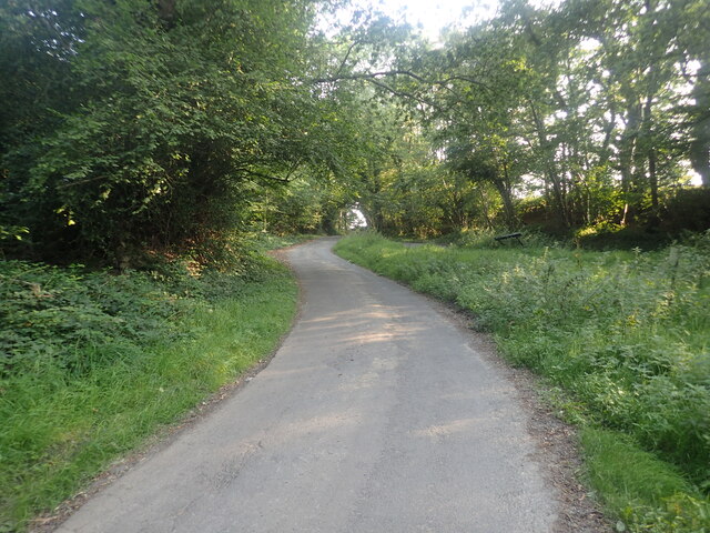
Bushy Wood is a picturesque woodland located in the county of Sussex, England. Spread over an area of approximately 100 acres, this forest is known for its dense foliage, diverse wildlife, and tranquil atmosphere. The wood is situated near the village of Horsted Keynes, making it easily accessible to visitors from nearby towns and cities.

As its name suggests, Bushy Wood is characterized by its lush green trees, including oak, beech, and birch, which form a dense canopy overhead. These trees create a serene environment, offering shade and tranquility to those who venture into the woodland. The forest floor is covered with a vibrant carpet of wildflowers, adding bursts of color to the landscape.

The wood is home to a wide variety of wildlife, making it a popular spot for nature enthusiasts and birdwatchers. Visitors may catch glimpses of roe deer, foxes, badgers, and a multitude of bird species, including woodpeckers, owls, and warblers. The forest's diverse ecosystem provides ample opportunities for wildlife observation and photography.

Bushy Wood offers numerous walking trails, allowing visitors to explore its natural beauty at their own pace. These paths wind through the forest, leading to hidden clearings and enchanting glades. The wood is well-maintained, with informative signage providing educational insights into the flora and fauna found within.

Whether visitors seek a peaceful stroll amidst nature, a chance to spot wildlife, or simply a break from the hustle and bustle of everyday life, Bushy Wood in Sussex offers a serene and captivating experience for all.

If you have any feedback on the listing, please let us know in the comments section below.

Bushy Wood Images

Images are sourced within 2km of 51.086685/0.21304707 or Grid Reference TQ5534. Thanks to Geograph Open Source API. All images are credited.

Eridge Rocks Eridge Rocks are owned and managed by the Sussex Wildlife Trust and extend for a considerable distance with a footpath running along the foot of them. They are 135 million years old and are described in the British Geological Survey: "Ashdown Formation - Sandstone And Siltstone, Interbedded. Sedimentary Bedrock formed approximately 134 to 145 million years ago in the Cretaceous Period. Local environment previously dominated by swamps, estuaries and deltas." The dinosaurs were wiped out 65 million years ago.

One of the information boards can be seen at <a title="https://www.geograph.org.uk/photo/6723121" href="https://www.geograph.org.uk/photo/6723121">Link</a>  I always think that this rock looks like a sphinx.
Eridge Rocks
Eridge Rocks are owned and managed by the Sussex Wildlife Trust and extend for a considerable distance with a footpath running along the foot of them. They are 135 million years old and are described in the British Geological Survey: "Ashdown Formation - Sandstone And Siltstone, Interbedded. Sedimentary Bedrock formed approximately 134 to 145 million years ago in the Cretaceous Period. Local environment previously dominated by swamps, estuaries and deltas." The dinosaurs were wiped out 65 million years ago. One of the information boards can be seen at Link I always think that this rock looks like a sphinx.
Eridge Rocks Eridge Rocks are owned and managed by the Sussex Wildlife Trust and extend for a considerable distance with a footpath running along the foot of them. They are 135 million years old and are described in the British Geological Survey: "Ashdown Formation - Sandstone And Siltstone, Interbedded. Sedimentary Bedrock formed approximately 134 to 145 million years ago in the Cretaceous Period. Local environment previously dominated by swamps, estuaries and deltas." The dinosaurs were wiped out 65 million years ago.

One of the information boards can be seen at <a title="https://www.geograph.org.uk/photo/6723121" href="https://www.geograph.org.uk/photo/6723121">Link</a>
Eridge Rocks
Eridge Rocks are owned and managed by the Sussex Wildlife Trust and extend for a considerable distance with a footpath running along the foot of them. They are 135 million years old and are described in the British Geological Survey: "Ashdown Formation - Sandstone And Siltstone, Interbedded. Sedimentary Bedrock formed approximately 134 to 145 million years ago in the Cretaceous Period. Local environment previously dominated by swamps, estuaries and deltas." The dinosaurs were wiped out 65 million years ago. One of the information boards can be seen at Link
The Sussex Border Path near Stitches Farm The Sussex Border Path drops down ahead to the valley of the Eridge Brook which also carries the Uckfield Line between Eridge and Crowborough. See <span class="nowrap"><a title="https://www.walkingenglishman.com/ldp/sussexborderpath.html" rel="nofollow ugc noopener" href="https://www.walkingenglishman.com/ldp/sussexborderpath.html">Link</a><img style="margin-left:2px;" alt="External link" title="External link - shift click to open in new window" src="https://s1.geograph.org.uk/img/external.png" width="10" height="10"/></span>
The Sussex Border Path near Stitches Farm
The Sussex Border Path drops down ahead to the valley of the Eridge Brook which also carries the Uckfield Line between Eridge and Crowborough. See LinkExternal link
The Deer Park Campsite This is just outside the Deer Park Cafe.
The Deer Park Campsite
This is just outside the Deer Park Cafe.
Sham Farm Road This looks downhill to Steel Bridge where Sham Farm Road crosses a stream.
Sham Farm Road
This looks downhill to Steel Bridge where Sham Farm Road crosses a stream.
Stream near Forge Wood House This stream flows from the main lake in Eridge Park.
Stream near Forge Wood House
This stream flows from the main lake in Eridge Park.
The Tunbridge Wells Circular Walk passes through Eridge Park The current Georgian-style house of Eridge Park was built in the late 1930s to replace the neo-Gothic Eridge Castle that had been inspired by Strawberry Hill House in Twickenham. The Castle had been begun in 1787. Eridge Park is said to be the oldest enclosed deer park in the country. The lakes were created in the 16th century to hold water to power iron works on the estate.
The Tunbridge Wells Circular Walk passes through Eridge Park
The current Georgian-style house of Eridge Park was built in the late 1930s to replace the neo-Gothic Eridge Castle that had been inspired by Strawberry Hill House in Twickenham. The Castle had been begun in 1787. Eridge Park is said to be the oldest enclosed deer park in the country. The lakes were created in the 16th century to hold water to power iron works on the estate.
Eridge Rocks Eridge Rocks are owned and managed by the Sussex Wildlife Trust and extend for a considerable distance with a footpath running along the foot of them. They are 135 million years old and are described in the British Geological Survey: "Ashdown Formation - Sandstone And Siltstone, Interbedded. Sedimentary Bedrock formed approximately 134 to 145 million years ago in the Cretaceous Period. Local environment previously dominated by swamps, estuaries and deltas." The dinosaurs were wiped out 65 million years ago.

One of the information boards can be seen at <a title="https://www.geograph.org.uk/photo/6723121" href="https://www.geograph.org.uk/photo/6723121">Link</a>  this formation is next to the car park.
Eridge Rocks
Eridge Rocks are owned and managed by the Sussex Wildlife Trust and extend for a considerable distance with a footpath running along the foot of them. They are 135 million years old and are described in the British Geological Survey: "Ashdown Formation - Sandstone And Siltstone, Interbedded. Sedimentary Bedrock formed approximately 134 to 145 million years ago in the Cretaceous Period. Local environment previously dominated by swamps, estuaries and deltas." The dinosaurs were wiped out 65 million years ago. One of the information boards can be seen at Link this formation is next to the car park.
Lake in Eridge Park The current Georgian-style house of Eridge Park was built in the late 1930s to replace the neo-Gothic Eridge Castle that had been inspired by Strawberry Hill House in Twickenham. The Castle had been begun in 1787. Eridge Park is said to be the oldest enclosed deer park in the country. The lakes were created in the 16th century to hold water to power iron works on the estate.

This view is from the Tunbridge Wells Circular Walk where it passes through the park. The house is at the top of the slope on the left, out of the picture.
Lake in Eridge Park
The current Georgian-style house of Eridge Park was built in the late 1930s to replace the neo-Gothic Eridge Castle that had been inspired by Strawberry Hill House in Twickenham. The Castle had been begun in 1787. Eridge Park is said to be the oldest enclosed deer park in the country. The lakes were created in the 16th century to hold water to power iron works on the estate. This view is from the Tunbridge Wells Circular Walk where it passes through the park. The house is at the top of the slope on the left, out of the picture.
Stitches Farm from the Sussex Border Path Beyond the farm, the Sussex Border Path drops down to the valley of the Eridge Brook which also carries the Uckfield Line between Eridge and Crowborough. See <span class="nowrap"><a title="https://www.walkingenglishman.com/ldp/sussexborderpath.html" rel="nofollow ugc noopener" href="https://www.walkingenglishman.com/ldp/sussexborderpath.html">Link</a><img style="margin-left:2px;" alt="External link" title="External link - shift click to open in new window" src="https://s1.geograph.org.uk/img/external.png" width="10" height="10"/></span>
Stitches Farm from the Sussex Border Path
Beyond the farm, the Sussex Border Path drops down to the valley of the Eridge Brook which also carries the Uckfield Line between Eridge and Crowborough. See LinkExternal link
The Sussex Border Path heading towards Stitches Farm Beyond the farm, the Sussex Border Path drops down to the valley of the Eridge Brook which also carries the Uckfield Line between Eridge and Crowborough. See <span class="nowrap"><a title="https://www.walkingenglishman.com/ldp/sussexborderpath.html" rel="nofollow ugc noopener" href="https://www.walkingenglishman.com/ldp/sussexborderpath.html">Link</a><img style="margin-left:2px;" alt="External link" title="External link - shift click to open in new window" src="https://s1.geograph.org.uk/img/external.png" width="10" height="10"/></span>
The Sussex Border Path heading towards Stitches Farm
Beyond the farm, the Sussex Border Path drops down to the valley of the Eridge Brook which also carries the Uckfield Line between Eridge and Crowborough. See LinkExternal link
The Sussex Border Path on the way to Stitches Farm Beyond the farm, the Sussex Border Path drops down to the valley of the Eridge Brook which also carries the Uckfield Line between Eridge and Crowborough. See <span class="nowrap"><a title="https://www.walkingenglishman.com/ldp/sussexborderpath.html" rel="nofollow ugc noopener" href="https://www.walkingenglishman.com/ldp/sussexborderpath.html">Link</a><img style="margin-left:2px;" alt="External link" title="External link - shift click to open in new window" src="https://s1.geograph.org.uk/img/external.png" width="10" height="10"/></span>
The Sussex Border Path on the way to Stitches Farm
Beyond the farm, the Sussex Border Path drops down to the valley of the Eridge Brook which also carries the Uckfield Line between Eridge and Crowborough. See LinkExternal link
Sham Farm Road The Deer Park Cafe and Camp Site is just ahead.
Sham Farm Road
The Deer Park Cafe and Camp Site is just ahead.
Sheep rounded up on the Tunbridge Wells Circular Walk These sheep had been expertly rounded up by two sheepdogs.
Sheep rounded up on the Tunbridge Wells Circular Walk
These sheep had been expertly rounded up by two sheepdogs.
View from Sandhill Lane This is close to and within the sound of the A26.
View from Sandhill Lane
This is close to and within the sound of the A26.
View from Sandhill Lane This is close to Sandhill Cottages and looks across the valley through which the Uckfield line runs.
View from Sandhill Lane
This is close to Sandhill Cottages and looks across the valley through which the Uckfield line runs.
Sandhill Lane Sandhill Lane here passes through Roughets Wood but keeps along the south side of the wood.
Sandhill Lane
Sandhill Lane here passes through Roughets Wood but keeps along the south side of the wood.
Triangular junction at Danegate There is a triangular junction where Danegate meets Sham Farm Road and Blackdon Hill. This view looks up from Danegate to Blackdon Hill. The triangle is on the right.
Triangular junction at Danegate
There is a triangular junction where Danegate meets Sham Farm Road and Blackdon Hill. This view looks up from Danegate to Blackdon Hill. The triangle is on the right.
Show me another place!

Bushy Wood is located at Grid Ref: TQ5534 (Lat: 51.086685, Lng: 0.21304707)

Administrative County: East Sussex

District: Wealden

Police Authority: Sussex

What 3 Words

///promising.owls.tripods. Near Groombridge, East Sussex

Related Wikis

Eridge railway station

Eridge railway station is on the Uckfield branch of the Oxted line in southern England and serves a rural district around Eridge in East Sussex. It is...

Eridge Green

Eridge Green is a 8.4-hectare (21-acre) biological Site of Special Scientific Interest north-east of Crowborough in East Sussex. It is part of the 44 hectares...
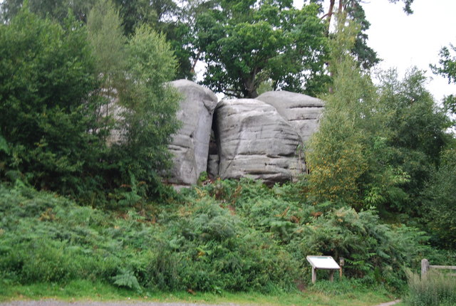
Bowles Rocks

Bowles Rocks is a sandstone crag in the county of East Sussex, on the border with Kent, approximately 8 kilometres (5 mi) south of the town of Royal Tunbridge...

Bowles Outdoor Centre

Bowles Outdoor Centre is an outdoor education/outdoor learning centre in southeast England, located between Royal Tunbridge Wells and Crowborough at Bowles...
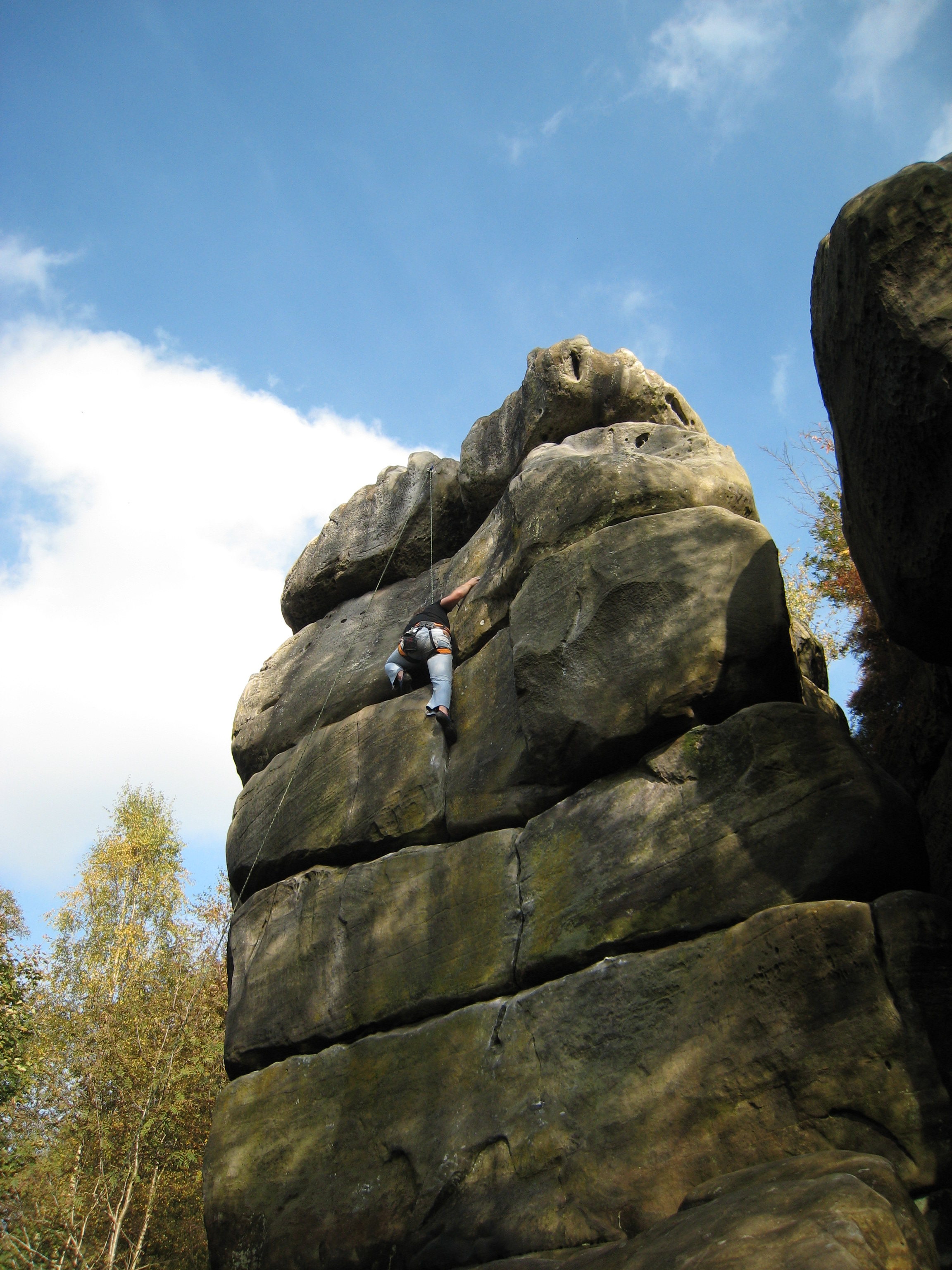
Harrison's Rocks

Harrison's Rocks is a series of sandstone crags approximately 1.5 kilometres (1 mi) south of the village of Groombridge in the county of East Sussex. The...

Eridge Park

Eridge Park () is a village and historic park located north of the parish of Rotherfield, to the north-east of Crowborough in East Sussex, England. The...

Penn's Rocks

Penn's Rocks is a 10.2-hectare (25-acre) biological Site of Special Scientific Interest north of Crowborough in East Sussex.This site is a steep sided...

High Rocks

High Rocks is a 3.2-hectare (7.9-acre) geological Site of Special Scientific Interest west of Tunbridge Wells in East Sussex and Kent. It is a Geological...

Nearby Amenities

Located within 500m of 51.086685,0.21304707
Barrier: stile
Lat/Long: 51.0867247/0.2175099
The data included in this document is from www.openstreetmap.org. The data is made available under ODbL.

Have you been to Bushy Wood?

Leave your review of Bushy Wood below (or comments, questions and feedback).