Beechen Wood

Wood, Forest in Sussex Wealden

England

Beechen Wood

Foxy Field/Round Field The name of the fields according to Withyham's 1842 tithe map that have been merged to form a larger unit. Foxy Field is in the foreground whilst Round Field is beyond the hedgerow in the distance adjacent to Badbrook Wood. Now part of Park Grove Deer Farm.
Foxy Field/Round Field Credit: Simon Carey

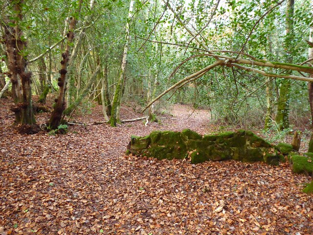
Beechen Wood is a picturesque woodland area located in the county of Sussex, England. Covering an expansive area of approximately 300 acres, it is considered one of the largest and most significant woodlands in the region. The wood is situated near the village of Battle, which is renowned for its historical significance as the site of the famous Battle of Hastings in 1066.

The wood is predominantly comprised of beech trees, which give it its name. These magnificent trees create a dense canopy that provides shelter and habitat for a diverse range of flora and fauna. Walking through Beechen Wood, visitors are greeted by an enchanting atmosphere created by the play of light filtering through the leaves, casting dappled shadows on the forest floor.

The woodland is home to a variety of wildlife species, including deer, badgers, foxes, and a plethora of bird species. The tranquil surroundings and abundance of natural resources make it an ideal habitat for these creatures to thrive.

In addition to its natural beauty, Beechen Wood offers a range of recreational activities for visitors. There are well-maintained walking trails that wind through the woodland, allowing nature enthusiasts to explore the area at their leisure. The wood also provides an opportunity for birdwatching, photography, and simply enjoying the peace and tranquility of the natural surroundings.

Overall, Beechen Wood is a captivating destination for nature lovers, offering a serene escape from the hustle and bustle of everyday life. Its rich biodiversity and scenic beauty make it a must-visit location for anyone seeking a connection with nature in the heart of Sussex.

If you have any feedback on the listing, please let us know in the comments section below.

Beechen Wood Images

Images are sourced within 2km of 51.0694/0.16794359 or Grid Reference TQ5132. Thanks to Geograph Open Source API. All images are credited.

Foxy Field/Round Field The name of the fields according to Withyham's 1842 tithe map that have been merged to form a larger unit. Foxy Field is in the foreground whilst Round Field is beyond the hedgerow in the distance adjacent to Badbrook Wood. Now part of Park Grove Deer Farm.
Foxy Field/Round Field
The name of the fields according to Withyham's 1842 tithe map that have been merged to form a larger unit. Foxy Field is in the foreground whilst Round Field is beyond the hedgerow in the distance adjacent to Badbrook Wood. Now part of Park Grove Deer Farm.
Park Grove/Long Field The name of the fields according to Withyham's 1842 tithe map that have been merged to form a larger unit. Park Grove is in the foreground whilst Long field was to the east adjacent to Badbrook Wood. Both are bounded to the south by Parkgrove Wood.
Park Grove/Long Field
The name of the fields according to Withyham's 1842 tithe map that have been merged to form a larger unit. Park Grove is in the foreground whilst Long field was to the east adjacent to Badbrook Wood. Both are bounded to the south by Parkgrove Wood.
Barn Mead The name of the field according to Withyham's 1842 tithe map located to the south of Park Grove.
Barn Mead
The name of the field according to Withyham's 1842 tithe map located to the south of Park Grove.
Park Grove Cottage Former farm outbuilding belonging to Parkgrove Farm whose original farmhouse, now called Home Place, can be seen in the distance.
Park Grove Cottage
Former farm outbuilding belonging to Parkgrove Farm whose original farmhouse, now called Home Place, can be seen in the distance.
Home Place Originally a farmhouse for Wiggs Farm later known as Parkgrove Farm. Now converted into a residence.
Home Place
Originally a farmhouse for Wiggs Farm later known as Parkgrove Farm. Now converted into a residence.
Park Lodge, Lye Green Built as a lodge for Park House around 1874.
Park Lodge, Lye Green
Built as a lodge for Park House around 1874.
Gate Field/Hollands Field The name of the fields according to Withyham's 1842 tithe map that have been merged to form a larger unit. Gate field was in the foreground whilst Hollands Field was on the slope in the distance.
Gate Field/Hollands Field
The name of the fields according to Withyham's 1842 tithe map that have been merged to form a larger unit. Gate field was in the foreground whilst Hollands Field was on the slope in the distance.
Gate Field The name of the field according to Withyham's 1842 tithe map located to the north of the High Weald Landscape Trail.
Gate Field
The name of the field according to Withyham's 1842 tithe map located to the north of the High Weald Landscape Trail.
Kiln Field The name of the field according to Withyham's 1842 tithe map located to the west of Littlebrook.
Kiln Field
The name of the field according to Withyham's 1842 tithe map located to the west of Littlebrook.
Four Acre Mead The name of the field according to Withyham's 1842 tithe map that is now part of Park Grove Deer Farm. The herd was lying against the fence as I approached and didn't take off as wild deer are prone to do but slowly rose and gradually moved further up the hill. A brave younger stag even decided to have a sniff at my hand when I put it through the fence. What was interesting was observing the herd's leader stag, clearly visible on the left, gently shift the herd away from the fence as I walked past them.
Four Acre Mead
The name of the field according to Withyham's 1842 tithe map that is now part of Park Grove Deer Farm. The herd was lying against the fence as I approached and didn't take off as wild deer are prone to do but slowly rose and gradually moved further up the hill. A brave younger stag even decided to have a sniff at my hand when I put it through the fence. What was interesting was observing the herd's leader stag, clearly visible on the left, gently shift the herd away from the fence as I walked past them.
The Reading Room, School Lane, St John's, Crowborough Built in the late 19th century as a reading room now home to St John's Preschool Nursery.
The Reading Room, School Lane, St John's, Crowborough
Built in the late 19th century as a reading room now home to St John's Preschool Nursery.
Fourways, School Lane, St John's, Crowborough Built in the first decade of the 20th century.
Fourways, School Lane, St John's, Crowborough
Built in the first decade of the 20th century.
St John's Primary School, School Lane, St John's, Crowborough The old part of the school dates from 1840 originally as a church school for nearby St John's. There is a newer block out of shot to the right.
St John's Primary School, School Lane, St John's, Crowborough
The old part of the school dates from 1840 originally as a church school for nearby St John's. There is a newer block out of shot to the right.
Providence Cottages, School Lane, St John's, Crowborough A set of four semi-detached cottages built in the first decade of the 20th century.
Providence Cottages, School Lane, St John's, Crowborough
A set of four semi-detached cottages built in the first decade of the 20th century.
Hazel Side and Forest Cottage, St John's, Crowborough Located in a small clearing next to Keyward's Wood. Hazel Side is on the left and Forest Cottage is to the right.
Hazel Side and Forest Cottage, St John's, Crowborough
Located in a small clearing next to Keyward's Wood. Hazel Side is on the left and Forest Cottage is to the right.
Ditch, High Wood Covered in fallen leaves and adjacent to the footpath heading to Frair's Gate Farm.
Ditch, High Wood
Covered in fallen leaves and adjacent to the footpath heading to Frair's Gate Farm.
Withyham 13a Public Footpath Crossing an unnamed tributary of King's Standing Gill in High Wood.
Withyham 13a Public Footpath
Crossing an unnamed tributary of King's Standing Gill in High Wood.
Withyham 13b Public Footpath Heading through what was once a field called Grubs Five Acres, according to Withyham's 1842 tithe map, hence the remnant of a stone wall on the footpath.
Withyham 13b Public Footpath
Heading through what was once a field called Grubs Five Acres, according to Withyham's 1842 tithe map, hence the remnant of a stone wall on the footpath.
Show me another place!

Beechen Wood is located at Grid Ref: TQ5132 (Lat: 51.0694, Lng: 0.16794359)

Administrative County: East Sussex

District: Wealden

Police Authority: Sussex

What 3 Words

///terribly.longer.timer. Near Crowborough, East Sussex

Related Wikis

Bream Wood

Bream Wood is a 7.8-hectare (19-acre) biological Site of Special Scientific Interest north of Crowborough in East Sussex.This steep sided valley wood has...

Crowborough Community Church

Crowborough Community Church (also known as Community Church, Crowborough) is an Evangelical church in the town of Crowborough in East Sussex, England...

Pratt's Mill, Crowborough

Pratt's Mill is a tower mill at Crowborough, Sussex, England which has been truncated and converted to residential accommodation. == History == Pratt...

Crowborough

Crowborough is a town and civil parish in East Sussex, England, in the Weald at the edge of Ashdown Forest in the High Weald Area of Outstanding Natural...

Beacon Academy

Beacon Academy (formerly Beacon Community College) is a coeducational secondary school and sixth form located in Crowborough in the English county of East...

A26 road

The A26 road is a primary route in the southeast of England, going from Maidstone to Newhaven through the counties of Kent and East Sussex. The road is...

Bowles Rocks

Bowles Rocks is a sandstone crag in the county of East Sussex, on the border with Kent, approximately 8 kilometres (5 mi) south of the town of Royal Tunbridge...

Bowles Outdoor Centre

Bowles Outdoor Centre is an outdoor education/outdoor learning centre in southeast England, located between Royal Tunbridge Wells and Crowborough at Bowles...

Nearby Amenities

Located within 500m of 51.0694,0.16794359
Generator Method: photovoltaic
Generator Output Electricity: yes
Generator Source: solar
Generator Type: solar_photovoltaic_panel
Location: roof
Power: generator
Lat/Long: 51.0661243/0.1636094
The data included in this document is from www.openstreetmap.org. The data is made available under ODbL.

Have you been to Beechen Wood?

Leave your review of Beechen Wood below (or comments, questions and feedback).