Chapman's Plantation

Wood, Forest in Cambridgeshire South Cambridgeshire

England

Chapman's Plantation

The A1303 This is a very busy road and waiting for a gap in the traffic took some time, even so there is a lorry and car visible.
The A1303 Credit: Malcolm Neal

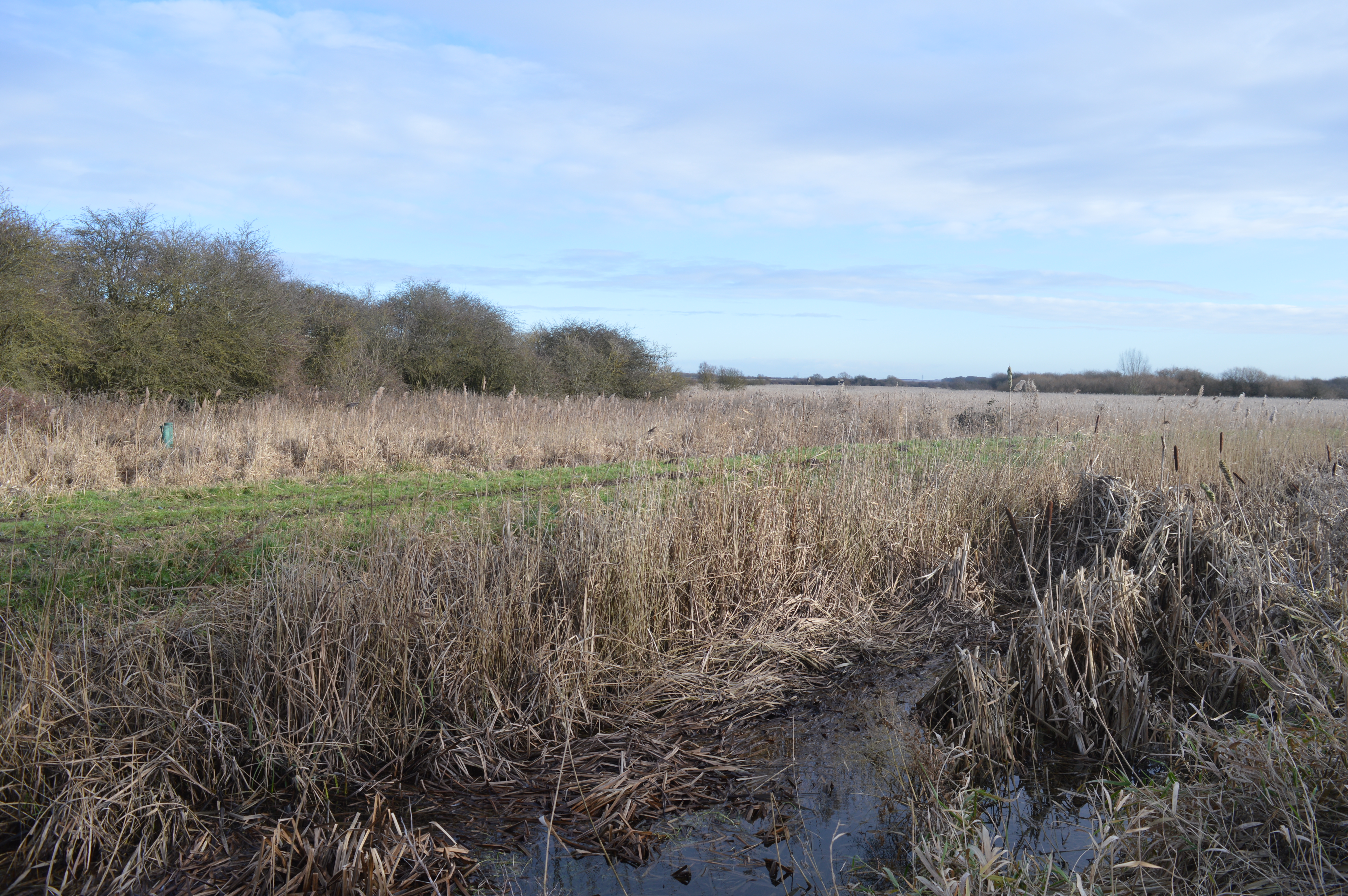
Chapman's Plantation is a picturesque woodland located in Cambridgeshire, England. Situated in the heart of the county, it covers an area of approximately 50 hectares. The plantation is part of the larger Thetford Forest, which spans across Norfolk and Suffolk as well.

The woodland is characterized by a diverse range of tree species, including oak, beech, birch, and pine. These trees create a dense canopy, providing ample shade and shelter for a variety of wildlife. Visitors to Chapman's Plantation can expect to encounter an array of bird species, such as woodpeckers, nightingales, and owls, as well as small mammals like squirrels and hedgehogs.

The plantation offers several well-maintained walking trails that wind through the woodland, allowing visitors to explore its natural beauty. These trails are suitable for all ages and fitness levels, and provide opportunities for both leisurely strolls and more challenging hikes. Along the way, hikers can enjoy beautiful views of the surrounding countryside and may even spot some of the plantation's resident deer.

Chapman's Plantation is a popular destination for nature lovers, birdwatchers, and families looking for a day out in a tranquil setting. The plantation is easily accessible, with ample parking available for visitors. Facilities such as picnic areas and toilets are also provided, ensuring a comfortable and enjoyable experience for all who visit this enchanting woodland retreat.

If you have any feedback on the listing, please let us know in the comments section below.

Chapman's Plantation Images

Images are sourced within 2km of 52.222152/0.20704817 or Grid Reference TL5060. Thanks to Geograph Open Source API. All images are credited.

The A1303 This is a very busy road and waiting for a gap in the traffic took some time, even so there is a lorry and car visible.
The A1303
This is a very busy road and waiting for a gap in the traffic took some time, even so there is a lorry and car visible.
Working the land in November Sugar beet has been lifted from this large field on the edge of the Cambridgeshire Fens and is on its way to the refinery - see <a href="https://www.geograph.org.uk/photo/7013788">TL5159 : Stow-cum-Quy: loading sugar beet</a>, taken a couple of minutes earlier. Stow-cum-Quy church tower is on the skyline in the centre of the picture.
Working the land in November
Sugar beet has been lifted from this large field on the edge of the Cambridgeshire Fens and is on its way to the refinery - see TL5159 : Stow-cum-Quy: loading sugar beet, taken a couple of minutes earlier. Stow-cum-Quy church tower is on the skyline in the centre of the picture.
Stow-cum-Quy: loading sugar beet Beet is piled at the edge of the field and a tractor and a conveyor transfer it to the lorry which will take it to the sugar refinery (the nearest is at Bury St Edmunds).
Stow-cum-Quy: loading sugar beet
Beet is piled at the edge of the field and a tractor and a conveyor transfer it to the lorry which will take it to the sugar refinery (the nearest is at Bury St Edmunds).
On High Ditch Road in September A view from the side of High Ditch Road, on the way to Fen Ditton, taken on a late-summer morning. The bridge in the distance on the right carries Low Fen Drove Way over the A14 and out into the fen.
On High Ditch Road in September
A view from the side of High Ditch Road, on the way to Fen Ditton, taken on a late-summer morning. The bridge in the distance on the right carries Low Fen Drove Way over the A14 and out into the fen.
Cycleway to the A1303 Newmarket Road Off High Ditch Road
Fen Ditton Cycleway No.51
Cycleway to the A1303 Newmarket Road
Off High Ditch Road Fen Ditton Cycleway No.51
High Ditch Road, Fen Ditton At the junction with the A1303 Newmarket Road
High Ditch Road, Fen Ditton
At the junction with the A1303 Newmarket Road
Cycleway signpost on High Ditch Road <span class="nowrap"><a title="https://en.wikipedia.org/wiki/Fen_Ditton" rel="nofollow ugc noopener" href="https://en.wikipedia.org/wiki/Fen_Ditton">Link</a><img style="margin-left:2px;" alt="External link" title="External link - shift click to open in new window" src="https://s1.geograph.org.uk/img/external.png" width="10" height="10"/></span>
Cycleway signpost on High Ditch Road
High Ditch Road, Fen Ditton At the junction with the A1303 Newmarket Road
High Ditch Road, Fen Ditton
At the junction with the A1303 Newmarket Road
High Ditch Road, Fen Ditton <span class="nowrap"><a title="https://en.wikipedia.org/wiki/Fen_Ditton" rel="nofollow ugc noopener" href="https://en.wikipedia.org/wiki/Fen_Ditton">Link</a><img style="margin-left:2px;" alt="External link" title="External link - shift click to open in new window" src="https://s1.geograph.org.uk/img/external.png" width="10" height="10"/></span>
High Ditch Road, Fen Ditton
Farmland off High Ditch Road <span class="nowrap"><a title="https://en.wikipedia.org/wiki/Fen_Ditton" rel="nofollow ugc noopener" href="https://en.wikipedia.org/wiki/Fen_Ditton">Link</a><img style="margin-left:2px;" alt="External link" title="External link - shift click to open in new window" src="https://s1.geograph.org.uk/img/external.png" width="10" height="10"/></span>
Farmland off High Ditch Road
House on the A1303 Newmarket Road Taken from  High Drift Road
House on the A1303 Newmarket Road
Taken from High Drift Road
Cycleway to the A1303 Newmarket Road Off High Ditch Road
Fen Ditton Cycleway No.51
Cycleway to the A1303 Newmarket Road
Off High Ditch Road Fen Ditton Cycleway No.51
Cycleway signpost on High Ditch Road Fen Ditton Cycleway No.51
Cycleway signpost on High Ditch Road
Fen Ditton Cycleway No.51
Cycleway signpost on High Ditch Road Fen Ditton Cycleway No.51
Cycleway signpost on High Ditch Road
Fen Ditton Cycleway No.51
High Ditch Road sign On High Ditch Road at the junction with the A1303 Newmarket Road
High Ditch Road sign
On High Ditch Road at the junction with the A1303 Newmarket Road
Roadsigns on the A1303 Newmarket Road At the junction with High Ditch Road
Roadsigns on the A1303 Newmarket Road
At the junction with High Ditch Road
Farmland looking towards the A1303 Newmarket Road Taken from High Ditch Road
Farmland looking towards the A1303 Newmarket Road
Taken from High Ditch Road
Near Quy Mill Hotel on a frosty morning On this very cold January morning there was fog out in The Fens, but in and near the city the sky was clear.
Near Quy Mill Hotel on a frosty morning
On this very cold January morning there was fog out in The Fens, but in and near the city the sky was clear.
Show me another place!

Chapman's Plantation is located at Grid Ref: TL5060 (Lat: 52.222152, Lng: 0.20704817)

Administrative County: Cambridgeshire

District: South Cambridgeshire

Police Authority: Cambridgeshire

What 3 Words

///tides.amazed.passing. Near Bottisham, Cambridgeshire

Nearby Locations

Chapman's Plantation

Related Wikis

Quy Hall

Quy Hall is a Grade II* listed English country house at Stow cum Quy, Cambridgeshire. Originally dating from the late 15th century, it was completely remodelled...

Stow cum Quy

Stow cum Quy , commonly referred to as Quy, is a village and civil parish in Cambridgeshire, England. Situated around 4 miles (6.4 km) north east of Cambridge...

Quy railway station

Quy railway station served the parish of Stow cum Quy, Cambridgeshire, England from 1884 to 1964 on the Cambridge to Mildenhall railway. == History... ==

Wilbraham Fens

Wilbraham Fens is a 62.5-hectare (154-acre) biological Site of Special Scientific Interest east of Cambridge.This is an example of a fen habitat, which...

Stow-Cum-Quy Fen

Stow-Cum-Quy Fen is a 29.9-hectare (74-acre) biological Site of Special Scientific Interest west of Lode in Cambridgeshire. Most of it is common land.The...

Horningsea

Horningsea is a small village north of Cambridge in Cambridgeshire in England. The parish covers an area of 2.6 square miles (6.7 km2; 1,700 acres). It...

Fen Ditton Halt railway station

Fen Ditton Halt railway station served the village of Fen Ditton, Cambridgeshire, England from 1922 to 1962 on the Cambridge to Mildenhall railway. �...

Fen Ditton

Fen Ditton is a village on the northeast edge of Cambridge in Cambridgeshire, England. The parish covers an area of 5.99 square kilometres (2 sq mi). Fen...

Nearby Amenities

Located within 500m of 52.222152,0.20704817
Design: barrel
Line Attachment: suspension
Power: tower
Ref: PTC 40
Source: survey
Source Geometry: yahoo
Lat/Long: 52.219495/0.2023888
Power: tower
Ref: PTC 39
Source: yahoo
Source Ref: survey
Lat/Long: 52.2216809/0.2007419
The data included in this document is from www.openstreetmap.org. The data is made available under ODbL.

Have you been to Chapman's Plantation?

Leave your review of Chapman's Plantation below (or comments, questions and feedback).