Kidman's Plantation

Wood, Forest in Cambridgeshire South Cambridgeshire

England

Kidman's Plantation

Memorial of Newton The memorial standing to remind you of those who died in the war that lived in Newton.
Memorial of Newton Credit: Finlay Cox

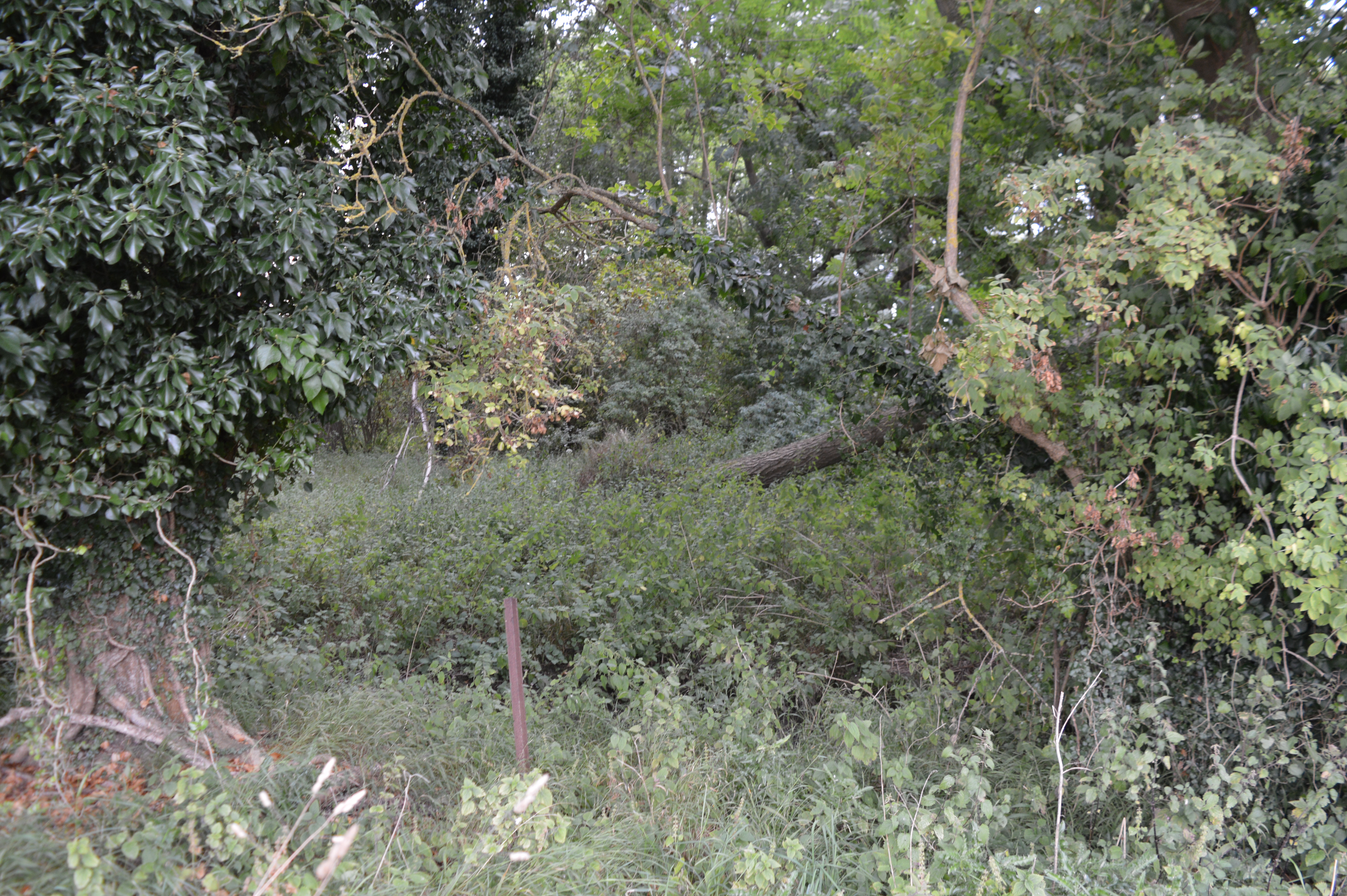
Kidman's Plantation is a picturesque woodland located in Cambridgeshire, England. Covering an area of approximately 50 acres, this enchanting forest offers visitors a serene and captivating natural environment.

The woodland is characterized by a diverse range of trees, including oak, beech, ash, and birch. These majestic trees create a dense canopy, providing shade and shelter for a variety of flora and fauna. The forest floor is adorned with a vibrant carpet of wildflowers, ferns, and mosses, adding to the enchanting atmosphere.

Kidman's Plantation is an ideal destination for nature lovers and outdoor enthusiasts. The woodland is crisscrossed by well-maintained footpaths and trails, allowing visitors to explore its beauty at their own pace. As they meander through the forest, visitors may encounter a plethora of wildlife, such as deer, foxes, squirrels, and a myriad of bird species.

The plantation also offers several recreational activities for visitors to enjoy. There are designated picnic areas where families and friends can relax, surrounded by the tranquility of nature. The forest also provides an excellent setting for birdwatching and photography, with its abundance of avian species and captivating scenery.

Kidman's Plantation is easily accessible, with ample parking facilities available nearby. The woodland is open to the public throughout the year, providing a peaceful retreat from the hustle and bustle of daily life.

In conclusion, Kidman's Plantation in Cambridgeshire is a captivating woodland that offers a serene and enchanting natural environment. With its diverse range of trees, abundant wildlife, and recreational activities, it is a must-visit destination for nature enthusiasts and those seeking solace in the beauty of the great outdoors.

If you have any feedback on the listing, please let us know in the comments section below.

Kidman's Plantation Images

Images are sourced within 2km of 52.1197/0.11208724 or Grid Reference TL4448. Thanks to Geograph Open Source API. All images are credited.

Memorial of Newton The memorial standing to remind you of those who died in the war that lived in Newton.
Memorial of Newton
The memorial standing to remind you of those who died in the war that lived in Newton.
Whittlesford Road Leaving Newton.
Whittlesford Road
Leaving Newton.
Cottage on the edge of Newton
Cockle Close, Newton New housing on the edge of the village.
Cockle Close, Newton
New housing on the edge of the village.
Thatched Cottage, Newton With a lick of paint since <a href="https://www.geograph.org.uk/photo/749751">TL4349 : Deep Thatch, Fowlmere Road</a>.
Thatched Cottage, Newton
With a lick of paint since TL4349 : Deep Thatch, Fowlmere Road.
Kidmans Close, Newton
Top Farm, Newton
Top Farm, Newton
Footpath to Newton Following a farm track.
Footpath to Newton
Following a farm track.
Footpath to Newton Along Hoffer Brook.
Footpath to Newton
Along Hoffer Brook.
Cycling to and from Newton Two cyclists, one with serious kit, the other with a camera, are about to pass on the bridleway which links Newton and Stapleford. It was a hot Sunday morning during the heatwave of autumn 2011.
Cycling to and from Newton
Two cyclists, one with serious kit, the other with a camera, are about to pass on the bridleway which links Newton and Stapleford. It was a hot Sunday morning during the heatwave of autumn 2011.
Sunday-morning traffic on the M11 Looking towards Cambridge from the bridge which carries the Newton-Stapleford bridleway.
Sunday-morning traffic on the M11
Looking towards Cambridge from the bridge which carries the Newton-Stapleford bridleway.
Bridle path and motorway bridge The bridge carries the Newton-Stapleford bridleway and was built with farm vehicles in mind. The sign gives early warning of Trumpington Park & Ride, near the next turn-off, Junction 11.
Bridle path and motorway bridge
The bridge carries the Newton-Stapleford bridleway and was built with farm vehicles in mind. The sign gives early warning of Trumpington Park & Ride, near the next turn-off, Junction 11.
Byway to Stapleford <a href="https://www.geograph.org.uk/photo/749805">TL4449 : Public Bridleway to the Shelfords</a> shows more or less the same view towards the M11 in Spring 2008, when South Cambridgeshire was rather greener than during the 2011 drought.
Byway to Stapleford
TL4449 : Public Bridleway to the Shelfords shows more or less the same view towards the M11 in Spring 2008, when South Cambridgeshire was rather greener than during the 2011 drought.
Cockle Hill Taken during the 2011 drought (and the September-October heatwave). Compare this picture with Duncan Grey's <a href="https://www.geograph.org.uk/photo/840222">TL4449 : Across the field to Cockle Hill</a> from June 2008.
Cockle Hill
Taken during the 2011 drought (and the September-October heatwave). Compare this picture with Duncan Grey's TL4449 : Across the field to Cockle Hill from June 2008.
Footpath to New Farm and Cambridge Road Taken during the 2011 drought (and the September-October heatwave). Compare this picture with Keith Edkins' <a href="https://www.geograph.org.uk/photo/749802">TL4449 : Public Footpath to New Farm Road</a>, taken in spring 2008.
Footpath to New Farm and Cambridge Road
Taken during the 2011 drought (and the September-October heatwave). Compare this picture with Keith Edkins' TL4449 : Public Footpath to New Farm Road, taken in spring 2008.
Newton: St Margaret A small cruciform 14th-century church with a tall Perpendicular tower, surrounded by tall trees.
Newton: St Margaret
A small cruciform 14th-century church with a tall Perpendicular tower, surrounded by tall trees.
Newton: St Margaret "Built of clunch. W tower, plastered, Perp...the chancel too much re-done to be of value" (Nikolaus Pevsner). Surrounded by tall trees and in a small churchyard, this 14th-century church and its tall tower are quite tricky to photograph. Colour seemed almost unreally vivid in the morning light of the first Sunday in October 2011, as the autumn heatwave continued.
Newton: St Margaret
"Built of clunch. W tower, plastered, Perp...the chancel too much re-done to be of value" (Nikolaus Pevsner). Surrounded by tall trees and in a small churchyard, this 14th-century church and its tall tower are quite tricky to photograph. Colour seemed almost unreally vivid in the morning light of the first Sunday in October 2011, as the autumn heatwave continued.
Newton: St Margaret - tower and churchyard Surrounded by tall trees and in a small churchyard, this 14th-century church and its imposing Perpendicular tower (grand enough for a much larger church) are quite tricky to photograph.
Newton: St Margaret - tower and churchyard
Surrounded by tall trees and in a small churchyard, this 14th-century church and its imposing Perpendicular tower (grand enough for a much larger church) are quite tricky to photograph.
Show me another place!

Kidman's Plantation is located at Grid Ref: TL4448 (Lat: 52.1197, Lng: 0.11208724)

Administrative County: Cambridgeshire

District: South Cambridgeshire

Police Authority: Cambridgeshire

What 3 Words

///huddled.glitz.shred. Near Whittlesford, Cambridgeshire

Nearby Locations

Kidman's Plantation

Related Wikis

Whittlesford - Thriplow Hummocky Fields

Whittlesford - Thriplow Hummocky Fields is a 55.6-hectare (137-acre) biological Site of Special Scientific Interest between Whittlesford and Thriplow in...

Queen's Head, Newton

The Queen's Head is a pub in Newton, Cambridgeshire, England. It is Grade II listed and has been a pub since 1729. It is on the Regional Inventory of...

Newton, South Cambridgeshire

Newton is a civil parish and small village in Cambridgeshire, England. Situated around 7 miles to the south-west of Cambridge, it lies on the old coaching...

Thriplow Peat Holes

Thriplow Peat Holes is a 12.2-hectare (30-acre) biological Site of Special Scientific Interest north-east of Thriplow in Cambridgeshire.The site has rare...

South Cambridgeshire

South Cambridgeshire is a local government district of Cambridgeshire, England, with a population of 162,119 at the 2021 census. It was formed on 1 April...

Thriplow Meadows

Thriplow Meadows is a 3.5-hectare (8.6-acre) biological Site of Special Scientific Interest in Thriplow in Cambridgeshire.The site has two fields with...

Rowley's Hill

Rowley's Hill is a hill in Cambridgeshire, near the villages of Harston and Newton. Although of only moderate height (50 m/164 ft), it has a relatively...

Thriplow

Thriplow () is a village in the civil parish of Thriplow and Heathfield, in Cambridgeshire, England, 8 miles (13 km) south of Cambridge. The village also...

Nearby Amenities

Located within 500m of 52.1197,0.11208724
Power: pole
Lat/Long: 52.1228053/0.1162046
Power: pole
Lat/Long: 52.1230407/0.1144832
Power: pole
Lat/Long: 52.1234225/0.1121903
Power: pole
Lat/Long: 52.117627/0.1174266
Power: pole
Lat/Long: 52.1198206/0.1150295
Power: pole
Lat/Long: 52.1217711/0.112983
Power: pole
Lat/Long: 52.1208122/0.1139617
Power: pole
Lat/Long: 52.1186974/0.1162472
Power: pole
Lat/Long: 52.1219237/0.1125027
Power: pole
Lat/Long: 52.1220835/0.112095
Power: pole
Lat/Long: 52.1236299/0.1107201
The data included in this document is from www.openstreetmap.org. The data is made available under ODbL.

Have you been to Kidman's Plantation?

Leave your review of Kidman's Plantation below (or comments, questions and feedback).