Lord Padgets Wood
Wood, Forest in Essex Epping Forest
England
Lord Padgets Wood

Lord Padget's Wood is a picturesque woodland area located in the county of Essex, England. Situated in the heart of Epping Forest, it covers an area of approximately 30 acres. The wood is named after Lord Padget, a prominent figure in the local history of Essex.
The woodland is characterized by a diverse range of tree species, including oak, beech, birch, and hornbeam. These trees create a dense canopy, providing shade and shelter for a variety of wildlife. The forest floor is covered in a thick layer of leaf litter, which supports a rich ecosystem of plants and small animals.
Lord Padget's Wood is a popular destination for nature enthusiasts and outdoor enthusiasts alike. It offers numerous walking trails, allowing visitors to explore the natural beauty of the area. The wood is particularly renowned for its bluebell displays in the spring, attracting photographers and nature lovers from far and wide.
In addition to its natural beauty, Lord Padget's Wood holds historical significance. It is rumored to have been a hiding place for outlaws and highwaymen in the past. The remnants of old pathways and stone structures can still be found within the wood, adding to its charm and mystique.
Overall, Lord Padget's Wood is a tranquil and enchanting woodland, offering a peaceful escape from the hustle and bustle of city life. Its combination of natural beauty and historical significance makes it a unique and cherished part of Essex's landscape.
If you have any feedback on the listing, please let us know in the comments section below.
Lord Padgets Wood Images
Images are sourced within 2km of 51.676572/0.029786507 or Grid Reference TQ4099. Thanks to Geograph Open Source API. All images are credited.


Lord Padgets Wood is located at Grid Ref: TQ4099 (Lat: 51.676572, Lng: 0.029786507)
Administrative County: Essex
District: Epping Forest
Police Authority: Essex
What 3 Words
///fire.lease.soap. Near Waltham Abbey, Essex
Nearby Locations
Related Wikis
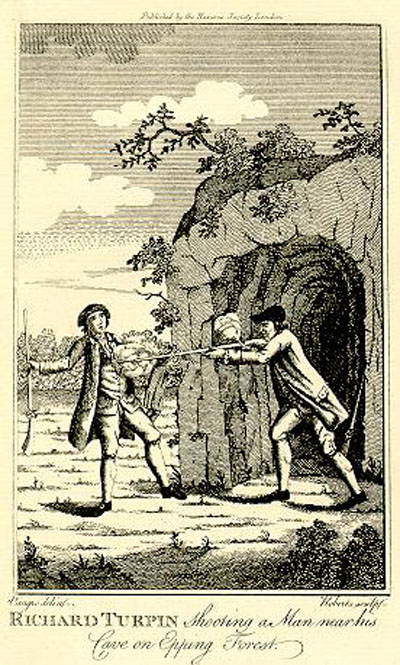
Turpin's Cave
Turpin's Cave is an area of Epping Forest in Essex which has been attributed as a hiding place of the highwayman Dick Turpin. Dick Turpin knew Epping...

High Beach
High Beach (or High Beech) is a village inside Epping Forest in south-west Essex, England. Part of the civil parish of Waltham Abbey, the village is within...

King Harold Business and Enterprise Academy
King Harold Business and Enterprise Academy (formerly King Harold School) is a secondary school and specialist business and enterprise college located...

Waltham Abbey F.C.
Waltham Abbey F.C. is an English football club based in Waltham Abbey, Essex. The team currently plays in the Southern League Division One Central....

Upshire
Upshire is a village and area of Waltham Abbey in the Epping Forest District of Essex, England. The centre of the village is on Horseshoe Hill (a minor...

Great Monk Wood
Great Monk Wood is a wood within Epping Forest, in Essex, England. The wood, in the parish of Loughton, is centred on the Wakes Arms junction roundabout...
Waltham Abbey
Waltham Abbey is a town and civil parish in the Epping Forest District of Essex, within the metropolitan and urban area of London, England, 13.5 miles...

Epping Forest
Epping Forest is a 2,400-hectare (5,900-acre) area of ancient woodland, and other established habitats, which straddles the border between Greater London...
Nearby Amenities
Located within 500m of 51.676572,0.029786507Have you been to Lord Padgets Wood?
Leave your review of Lord Padgets Wood below (or comments, questions and feedback).