Threecorner Grove

Wood, Forest in Surrey

England

Threecorner Grove

The Bull Inn, Chelsham Common, CR6 South aspect, with cricket pitch in foreground.
The Bull Inn, Chelsham Common, CR6 Credit: Philip Talmage

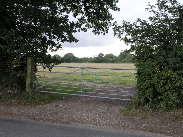
Threecorner Grove, located in Surrey, England, is a picturesque woodland area known for its natural beauty and serene atmosphere. Situated in the heart of Surrey's countryside, this enchanting forest offers visitors a tranquil escape from the hustle and bustle of everyday life.

Covering an area of approximately 100 acres, Threecorner Grove is characterized by its dense and diverse tree population. The forest is predominantly composed of oak, beech, and birch trees, which create a lush and green canopy overhead. Walking through the grove, visitors can immerse themselves in the soothing sounds of nature, with the rustling of leaves and the occasional chirping of birds.

The woodland is crisscrossed with well-maintained footpaths, providing visitors with the opportunity to explore the area at their own pace. These paths wind through the forest, leading to hidden clearings and secluded picnic spots. Additionally, the grove is home to a small stream, meandering its way through the trees, adding to the overall charm of the location.

Threecorner Grove is a popular destination for outdoor enthusiasts, offering a range of activities such as hiking, birdwatching, and photography. The forest's diverse ecosystem attracts a variety of bird species, making it a haven for birdwatchers seeking to spot rare and unique feathered creatures.

In conclusion, Threecorner Grove in Surrey is a stunning woodland area that promises a peaceful and immersive experience in the heart of nature. Whether you're looking for a quiet stroll or an adventurous hike, this forest offers something for everyone, making it a must-visit destination for nature lovers in Surrey.

If you have any feedback on the listing, please let us know in the comments section below.

Threecorner Grove Images

Images are sourced within 2km of 51.332596/-0.013464799 or Grid Reference TQ3861. Thanks to Geograph Open Source API. All images are credited.

The Bull Inn, Chelsham Common, CR6 South aspect, with cricket pitch in foreground.
The Bull Inn, Chelsham Common, CR6
South aspect, with cricket pitch in foreground.
Farm gate Some fields, intersected by a road which follows the course of an old Roman Road. The path of the roman road can be seen just behind the gate.
Farm gate
Some fields, intersected by a road which follows the course of an old Roman Road. The path of the roman road can be seen just behind the gate.
St Leonard, Chelsham, Surrey - Wall monument
Holt Wood, Chelsham (2) Plenty of oaks in this woodland.
Holt Wood, Chelsham (2)
Plenty of oaks in this woodland.
Holt Wood, Chelsham (3) Three curious bits of equipment. The middle one appears to be holding up the tree, but that could be an illusion.
Fellow Geographer 4wd has suggested that the contraption on the left might be a (fence) stake driver or a hydraulic powered log-splitter, and the red one a log splitter.
Holt Wood, Chelsham (3)
Three curious bits of equipment. The middle one appears to be holding up the tree, but that could be an illusion. Fellow Geographer 4wd has suggested that the contraption on the left might be a (fence) stake driver or a hydraulic powered log-splitter, and the red one a log splitter.
Oak, Chelsham Splendidly intricate and convoluted branches of one of many oaks in Holt Wood.
Oak, Chelsham
Splendidly intricate and convoluted branches of one of many oaks in Holt Wood.
Former water tower, Chelsham All that remains of the former Warlingham Park Hospital, a psychiatric hospital which closed in 1999. A free-standing Venetian-style campanile of polychromatic brick designed by G.H. Oatley and W.S. Skinner. Grade II listed.
 The rest of the site is now an upmarket, gated housing estate of no architectural interest.
Former water tower, Chelsham
All that remains of the former Warlingham Park Hospital, a psychiatric hospital which closed in 1999. A free-standing Venetian-style campanile of polychromatic brick designed by G.H. Oatley and W.S. Skinner. Grade II listed. The rest of the site is now an upmarket, gated housing estate of no architectural interest.
Fields near Chelsham A number of shaws, or small woods, on either side of the small valley.
Fields near Chelsham
A number of shaws, or small woods, on either side of the small valley.
Scotshall Lane, Chelsham Lined with large broadleaved trees - beeches and limes among others.
Scotshall Lane, Chelsham
Lined with large broadleaved trees - beeches and limes among others.
Railpit Lane, Fickleshole A byway which I'm sure these days sees only human, canine or equine feet.
Railpit Lane, Fickleshole
A byway which I'm sure these days sees only human, canine or equine feet.
Footpath 501 towards  Chelsham church This short path has rather unusual direction signs - large blue-backed arrows more usually seen on one-way roads. One is just visible at the track corner where the path goes left across a field, but the vehicle track goes right.
Footpath 501 towards Chelsham church
This short path has rather unusual direction signs - large blue-backed arrows more usually seen on one-way roads. One is just visible at the track corner where the path goes left across a field, but the vehicle track goes right.
Fairchildes Lane, near Warlingham Fairchildes Lane is a minor road on the North Downs.
Fairchildes Lane, near Warlingham
Fairchildes Lane is a minor road on the North Downs.
Fairchildes Lane It is a little confusing as to what this road is called as the same map shows both Fairchildes Lane or Fairchildes Road depending on whether you zoom in or not. This is close to Honeyoak Wood and is looking in the direction of Fickleshole.
Fairchildes Lane
It is a little confusing as to what this road is called as the same map shows both Fairchildes Lane or Fairchildes Road depending on whether you zoom in or not. This is close to Honeyoak Wood and is looking in the direction of Fickleshole.
Fairchildes Lane It is a little confusing as to what this road is called as the same map shows both Fairchildes Lane or Fairchildes Road depending on whether you zoom in or not. This is close to Honeyoak Wood, which is just on the right here, and is looking in the direction of Fickleshole.
Fairchildes Lane
It is a little confusing as to what this road is called as the same map shows both Fairchildes Lane or Fairchildes Road depending on whether you zoom in or not. This is close to Honeyoak Wood, which is just on the right here, and is looking in the direction of Fickleshole.
Byway alongside Honeyoak Wood This leads from Fairchildes Lane and when it emerges from Honeyoak Wood it becomes a track called Railpit Lane.
Byway alongside Honeyoak Wood
This leads from Fairchildes Lane and when it emerges from Honeyoak Wood it becomes a track called Railpit Lane.
The Vanguard Way approaching Farleigh Church Ian Nairn in 'The Buildings of England: Surrey' says of Farleigh - "Tiny hamlet on the North Downs, quite unspoilt - almost the most rural in Surrey. This extraordinary place is four miles from the centre of Croydon, eleven from the Isle of Dogs, and almost within sight of some of the worst sprawl in the country at New Addington." St Mary's Church is "as surprising a survival for Surrey as the village: Simple village-Norman, fairly gently restored, with new chancel arch and simple new bell-turret. All stuccoed, and not a window later than 1250. Nave and chancel c.1100."

Basil Cracknell in 'A Portrait of Surrey' writes about Farleigh - "My favourite oasis is Farleigh, with its tiny Norman church of St Mary's, damaged badly by fire in 1964 but still standing, as it has stood for 850 years, the smallest and one of the oldest churches in Surrey." Farleigh resisted its incorporation into Greater London in the 1960s so fiercely that it won its case and stayed in Surrey. "The essence of Farleigh's claim was that it was not an oasis at all, since it did not lie within the desert but belonged to the green country beyond it. Farleigh they said was rural in character, had been rural for all its recorded history, and wanted to stay that way - and they won their case."

St Mary's Church is just beyond the trees in the centre with the church car park on this side of the trees - see <a title="https://www.geograph.org.uk/photo/5453495" href="https://www.geograph.org.uk/photo/5453495">Link</a>
The Vanguard Way approaching Farleigh Church
Ian Nairn in 'The Buildings of England: Surrey' says of Farleigh - "Tiny hamlet on the North Downs, quite unspoilt - almost the most rural in Surrey. This extraordinary place is four miles from the centre of Croydon, eleven from the Isle of Dogs, and almost within sight of some of the worst sprawl in the country at New Addington." St Mary's Church is "as surprising a survival for Surrey as the village: Simple village-Norman, fairly gently restored, with new chancel arch and simple new bell-turret. All stuccoed, and not a window later than 1250. Nave and chancel c.1100." Basil Cracknell in 'A Portrait of Surrey' writes about Farleigh - "My favourite oasis is Farleigh, with its tiny Norman church of St Mary's, damaged badly by fire in 1964 but still standing, as it has stood for 850 years, the smallest and one of the oldest churches in Surrey." Farleigh resisted its incorporation into Greater London in the 1960s so fiercely that it won its case and stayed in Surrey. "The essence of Farleigh's claim was that it was not an oasis at all, since it did not lie within the desert but belonged to the green country beyond it. Farleigh they said was rural in character, had been rural for all its recorded history, and wanted to stay that way - and they won their case." St Mary's Church is just beyond the trees in the centre with the church car park on this side of the trees - see Link
Farleigh Church seen from Greatpark Wood Ian Nairn in 'The Buildings of England: Surrey' says of Farleigh - "Tiny hamlet on the North Downs, quite unspoilt - almost the most rural in Surrey. This extraordinary place is four miles from the centre of Croydon, eleven from the Isle of Dogs, and almost within sight of some of the worst sprawl in the country at New Addington." St Mary's Church is "as surprising a survival for Surrey as the village: Simple village-Norman, fairly gently restored, with new chancel arch and simple new bell-turret. All stuccoed, and not a window later than 1250. Nave and chancel c.1100."

Basil Cracknell in 'A Portrait of Surrey' writes about Farleigh - "My favourite oasis is Farleigh, with its tiny Norman church of St Mary's, damaged badly by fire in 1964 but still standing, as it has stood for 850 years, the smallest and one of the oldest churches in Surrey." Farleigh resisted its incorporation into Greater London in the 1960s so fiercely that it won its case and stayed in Surrey. "The essence of Farleigh's claim was that it was not an oasis at all, since it did not lie within the desert but belonged to the green country beyond it. Farleigh they said was rural in character, had been rural for all its recorded history, and wanted to stay that way - and they won their case."

St Mary's Church can just be seen above the trees in the centre with the church car park on this side of the trees beyond the horses - see <a title="https://www.geograph.org.uk/photo/5453495" href="https://www.geograph.org.uk/photo/5453495">Link</a>  The Vanguard Way is just the other side of the fence on the left - see <a title="https://www.geograph.org.uk/photo/5453510" href="https://www.geograph.org.uk/photo/5453510">Link</a>
Farleigh Church seen from Greatpark Wood
Ian Nairn in 'The Buildings of England: Surrey' says of Farleigh - "Tiny hamlet on the North Downs, quite unspoilt - almost the most rural in Surrey. This extraordinary place is four miles from the centre of Croydon, eleven from the Isle of Dogs, and almost within sight of some of the worst sprawl in the country at New Addington." St Mary's Church is "as surprising a survival for Surrey as the village: Simple village-Norman, fairly gently restored, with new chancel arch and simple new bell-turret. All stuccoed, and not a window later than 1250. Nave and chancel c.1100." Basil Cracknell in 'A Portrait of Surrey' writes about Farleigh - "My favourite oasis is Farleigh, with its tiny Norman church of St Mary's, damaged badly by fire in 1964 but still standing, as it has stood for 850 years, the smallest and one of the oldest churches in Surrey." Farleigh resisted its incorporation into Greater London in the 1960s so fiercely that it won its case and stayed in Surrey. "The essence of Farleigh's claim was that it was not an oasis at all, since it did not lie within the desert but belonged to the green country beyond it. Farleigh they said was rural in character, had been rural for all its recorded history, and wanted to stay that way - and they won their case." St Mary's Church can just be seen above the trees in the centre with the church car park on this side of the trees beyond the horses - see Link The Vanguard Way is just the other side of the fence on the left - see Link
Church Lane, near Warlingham Church Lane passing through woodland in north east Surrey.
Church Lane, near Warlingham
Church Lane passing through woodland in north east Surrey.
Show me another place!

Threecorner Grove is located at Grid Ref: TQ3861 (Lat: 51.332596, Lng: -0.013464799)

Unitary Authority: Croydon

Police Authority: Metropolitan

What 3 Words

///acute.decreased.hails. Near Warlingham, Surrey

Related Wikis

Hutchinson's Bank

Hutchinson's Bank is 21.8 hectare Local Nature Reserve and Site of Metropolitan Importance for Nature Conservation in New Addington in the London Borough...

Meridian High School, Croydon

Meridian High School is a coeducational secondary school with academy status, located in the New Addington area of the London Borough of Croydon, England...

New Addington Library

New Addington Library is a public library in New Addington, South London. It stands in the London Borough of Croydon and is part of the Croydon Libraries...

New Addington

New Addington is an area of South London, England, within the London Borough of Croydon. It is located 5 miles south east of Croydon and is adjacent to...

New Addington tram stop

New Addington is a terminal tram stop serving the centre of New Addington, in the London Borough of Croydon, in the southern suburbs of London. The tram...

Addington Vale

Addington Vale is a 48 acres (19 ha) park situated in New Addington in the London Borough of Croydon. The park extends from King Henrys Drive in the north...

King Henry's Drive tram stop

King Henry's Drive tram stop is a light rail stop serving the Betchworth Way residential area of New Addington, in the London Borough of Croydon in the...

Farleigh, Surrey

Farleigh is a village and former civil parish, now in the parish of Chelsham and Farleigh in the Tandridge district of Surrey, England. It is located in...

Nearby Amenities

Located within 500m of 51.332596,-0.013464799
Ref GB Tflcid: RWG202731
Traffic Calming: cushion
Lat/Long: 51.3342517/-0.0101886
Ref GB Tflcid: RWG202733
Traffic Calming: cushion
Lat/Long: 51.3340691/-0.0081325
Ref GB Tflcid: RWG202732
Traffic Calming: cushion
Lat/Long: 51.3341402/-0.009067
Ref GB Tflcid: RWG202727
Traffic Calming: cushion
Lat/Long: 51.3352051/-0.0109297
Turning Circle
Lat/Long: 51.3348656/-0.0118991
Turning Circle
Lat/Long: 51.3361123/-0.0143877
Bus Stop
Kennelwood Crescent
Bus: yes
Naptan AtcoCode: 490008640N
Naptan Bearing: N
Naptan CommonName: Kennelwood Crescent
Naptan Street: HOMESTEAD WAY
Naptan Verified: no
Public Transport: platform
Ref: 51590
Source Ref: naptan
Lat/Long: 51.3352063/-0.0104849
Bus Stop
Kennelwood Crescent
Bus: yes
Naptan AtcoCode: 490008640S
Naptan Bearing: N
Naptan CommonName: Kennelwood Crescent
Naptan Street: HOMESTEAD WAY
Naptan Verified: no
Public Transport: platform
Ref: 50067
Source Ref: naptan
Lat/Long: 51.3350332/-0.0097406
Post Box
Operator: Royal Mail
Operator Wikidata: Q638098
Ref: CR0 535
Lat/Long: 51.3353636/-0.010624
Barrier: kissing_gate
Source: survey
Lat/Long: 51.3337245/-0.0118074
Barrier: kissing_gate
Source: survey
Lat/Long: 51.3346898/-0.0135494
Barrier: kissing_gate
Source: survey
Lat/Long: 51.335307/-0.0147139
Note: Additional node marks deviation of Low Emission Zone.
Lat/Long: 51.3315325/-0.0134554
Ref GB Tflcid: RWG202734
Traffic Calming: cushion
Lat/Long: 51.3339037/-0.006909
Ref GB Tflcid: RWG202729
Traffic Calming: cushion
Lat/Long: 51.3344935/-0.0107557
Street Lamp
Lat/Long: 51.3351971/-0.0108768
Street Lamp
Lat/Long: 51.3348127/-0.0109559
Street Lamp
Lat/Long: 51.3342178/-0.0098201
Street Lamp
Lat/Long: 51.3341122/-0.0091755
Street Lamp
Lat/Long: 51.3341356/-0.0084664
Street Lamp
Lat/Long: 51.3340052/-0.0078703
Street Lamp
Lat/Long: 51.3339796/-0.0071582
Street Lamp
Lat/Long: 51.3337976/-0.0065568
Street Lamp
Lat/Long: 51.3347009/-0.0075033
Street Lamp
Lat/Long: 51.3346944/-0.0080225
Street Lamp
Lat/Long: 51.3362285/-0.0103902
Street Lamp
Lat/Long: 51.3357936/-0.009827
Street Lamp
Lat/Long: 51.3351655/-0.0088699
Street Lamp
Lat/Long: 51.3353386/-0.0105645
Street Lamp
Lat/Long: 51.3366175/-0.0122633
Street Lamp
Lat/Long: 51.3365808/-0.0107098
Street Lamp
Lat/Long: 51.3366295/-0.0109865
Street Lamp
Lat/Long: 51.3342963/-0.0104556
Street Lamp
Lat/Long: 51.3342415/-0.0108087
Street Lamp
Lat/Long: 51.3341735/-0.0113695
Street Lamp
Lat/Long: 51.3344429/-0.0118466
Street Lamp
Lat/Long: 51.3348138/-0.0119958
Barrier: bollard
Lat/Long: 51.33476/-0.011271
Barrier: bollard
Lat/Long: 51.3347746/-0.0112749
Barrier: bollard
Lat/Long: 51.3347369/-0.0112648
Barrier: bollard
Lat/Long: 51.3348625/-0.0111275
Barrier: bollard
Lat/Long: 51.3348441/-0.0111253
Barrier: bollard
Lat/Long: 51.3348247/-0.0111202
Barrier: bollard
Lat/Long: 51.3348046/-0.0111145
Barrier: bollard
Lat/Long: 51.3347439/-0.0110903
Barrier: bollard
Lat/Long: 51.3347245/-0.011079
Barrier: bollard
Lat/Long: 51.3347055/-0.0110688
Barrier: bollard
Lat/Long: 51.3346885/-0.0110592
Street Lamp
Lat/Long: 51.335481/-0.0122076
Barrier: bollard
Lat/Long: 51.3355908/-0.0123847
Barrier: bollard
Lat/Long: 51.3355813/-0.0124021
Barrier: bollard
Lat/Long: 51.3355718/-0.0124194
Barrier: bollard
Lat/Long: 51.335562/-0.0124367
Barrier: bollard
Lat/Long: 51.3355531/-0.0124536
Barrier: bollard
Lat/Long: 51.3355438/-0.0124705
Barrier: bollard
Lat/Long: 51.3355369/-0.0124841
Barrier: bollard
Lat/Long: 51.3355285/-0.0124997
Street Lamp
Lat/Long: 51.3353278/-0.0124617
Street Lamp
Lat/Long: 51.335761/-0.0129359
Street Lamp
Lat/Long: 51.3356607/-0.0133032
Street Lamp
Lat/Long: 51.3357113/-0.0135517
Street Lamp
Lat/Long: 51.3359241/-0.0138565
Street Lamp
Lat/Long: 51.3362006/-0.0137903
Street Lamp
Lat/Long: 51.3364062/-0.0140862
Street Lamp
Lat/Long: 51.3361895/-0.0133452
Street Lamp
Lat/Long: 51.33602/-0.0129039
Street Lamp
Lat/Long: 51.3354852/-0.0110779
Street Lamp
Lat/Long: 51.3357398/-0.0114698
Street Lamp
Lat/Long: 51.3360053/-0.0118
Street Lamp
Lat/Long: 51.3357594/-0.0122364
Street Lamp
Lat/Long: 51.3358267/-0.0127072
Street Lamp
Lat/Long: 51.3363045/-0.0131516
Street Lamp
Lat/Long: 51.336343/-0.0136922
Street Lamp
Lat/Long: 51.3365609/-0.0139724
Street Lamp
Lat/Long: 51.3353047/-0.013147
Street Lamp
Lat/Long: 51.3354931/-0.013405
Street Lamp
Lat/Long: 51.3360065/-0.0141827
Street Lamp
Lat/Long: 51.3368025/-0.0139428
Street Lamp
Lat/Long: 51.3370177/-0.0143166
Barrier: bollard
Lat/Long: 51.3370112/-0.0136716
Barrier: bollard
Lat/Long: 51.3370201/-0.0136596
Barrier: bollard
Lat/Long: 51.3370267/-0.0136472
Barrier: bollard
Lat/Long: 51.3370345/-0.0136334
The data included in this document is from www.openstreetmap.org. The data is made available under ODbL.

Have you been to Threecorner Grove?

Leave your review of Threecorner Grove below (or comments, questions and feedback).