Barnfield Shaw

Wood, Forest in Surrey Tandridge

England

Barnfield Shaw

Posterngate Farm, South Godstone, Surrey Part of the extensive grounds of Posterngate Farm, where the many activities include the maintenance of a herd of pedigree Charollais, and a lake for trout fishing.  There is even a small business park.  
And this photograph 'wraps up' the TQ34 hectad, of which I have claimed 48 first geographs.
Posterngate Farm, South Godstone, Surrey Credit: Dr Neil Clifton

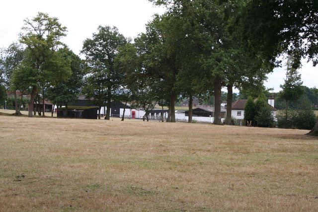
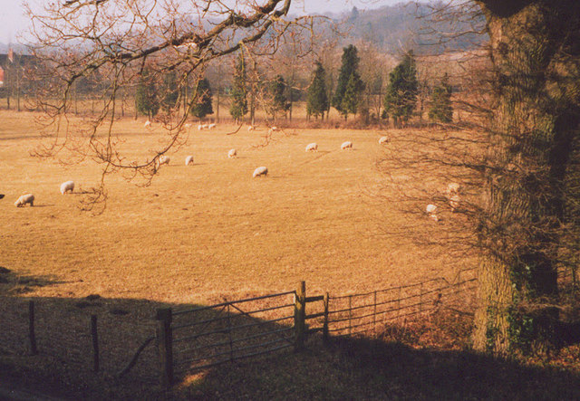
Barnfield Shaw is a picturesque woodland located in Surrey, England. Spread across a sprawling area, it is renowned for its natural beauty and serene ambiance. The woodland is characterized by its dense canopies of trees, predominantly consisting of oak, beech, and birch. The interplay of sunlight filtering through the foliage creates a captivating and tranquil atmosphere.

The forest floor is adorned with a rich variety of flora, including bluebells, ferns, and wild garlic, which add vibrant colors and scents to the surroundings. These diverse plant species make Barnfield Shaw a haven for wildlife, attracting a plethora of animals such as deer, rabbits, squirrels, and a wide array of bird species.

The woodland offers numerous walking trails and paths, allowing visitors to explore its beauty at their own pace. These trails often lead to hidden pockets of tranquility, where one can sit and immerse themselves in the peacefulness of nature. The forest is also home to a small stream, which meanders through the trees, providing a soothing soundtrack to accompany the serenity of the surroundings.

Barnfield Shaw is a popular destination for nature enthusiasts, photographers, and families looking to escape the bustling city life. Its accessibility and proximity to nearby towns make it an ideal day trip destination. The woodland provides an excellent opportunity for outdoor activities such as picnicking, birdwatching, and nature photography.

Overall, Barnfield Shaw in Surrey is a true gem, offering a serene and enchanting experience for all those who visit.

If you have any feedback on the listing, please let us know in the comments section below.

Barnfield Shaw Images

Images are sourced within 2km of 51.22583/-0.053513073 or Grid Reference TQ3649. Thanks to Geograph Open Source API. All images are credited.

Posterngate Farm, South Godstone, Surrey Part of the extensive grounds of Posterngate Farm, where the many activities include the maintenance of a herd of pedigree Charollais, and a lake for trout fishing.  There is even a small business park.  
And this photograph 'wraps up' the TQ34 hectad, of which I have claimed 48 first geographs.
Posterngate Farm, South Godstone, Surrey
Part of the extensive grounds of Posterngate Farm, where the many activities include the maintenance of a herd of pedigree Charollais, and a lake for trout fishing. There is even a small business park. And this photograph 'wraps up' the TQ34 hectad, of which I have claimed 48 first geographs.
South Godstone South Godstone is 3 miles south of Godstone village and developed when the Tonbridge railway line was built in the 19th century.
South Godstone
South Godstone is 3 miles south of Godstone village and developed when the Tonbridge railway line was built in the 19th century.
Fox and Hounds at South Godstone This building has served ale since the 17th century. On the Tilburstow Hill Road and well worth the diversion !
Fox and Hounds at South Godstone
This building has served ale since the 17th century. On the Tilburstow Hill Road and well worth the diversion !
St Mark's Foundation A private chapel at South Park Farm, listed grade II and occasionally used for public services.
St Mark's Foundation
A private chapel at South Park Farm, listed grade II and occasionally used for public services.
Wychcroft Retreat House Anglican Diocese of Southwark Retreat House used for residential training and quiet days
Wychcroft Retreat House
Anglican Diocese of Southwark Retreat House used for residential training and quiet days
Piper's Wood  and Oilseed Rape Field A field of ripe oilseed rape can be seen in the foreground with Piper's wood behind.
Piper's Wood and Oilseed Rape Field
A field of ripe oilseed rape can be seen in the foreground with Piper's wood behind.
Houses in Terra Cotta Road, Surrey Terra Cotta Road leads westwards off Tilburstow Hill Road.  It continues past these houses to end in a small business park.  These houses are probably the nearest you will get to 'affordable' houses in the Godstone area - but you will get a shock if you enquire the price.
Houses in Terra Cotta Road, Surrey
Terra Cotta Road leads westwards off Tilburstow Hill Road. It continues past these houses to end in a small business park. These houses are probably the nearest you will get to 'affordable' houses in the Godstone area - but you will get a shock if you enquire the price.
Little Chef restaurant, South Godstone, Surrey On the west side of the A22.
I suppose some people must actually eat in these establishments, otherwise they would not be there.
Little Chef restaurant, South Godstone, Surrey
On the west side of the A22. I suppose some people must actually eat in these establishments, otherwise they would not be there.
The chapel at Wychcroft An unusual private chapel, dedicated to the People of God, part of the Southwark diocesan retreat house and training centre.
The chapel at Wychcroft
An unusual private chapel, dedicated to the People of God, part of the Southwark diocesan retreat house and training centre.
Sheep grazing at Wychcroft A pastoral scene near Bletchingley.
Sheep grazing at Wychcroft
A pastoral scene near Bletchingley.
Godstone Station, Surrey
The Lagham Public House, Eastbourne Road, South Godstone, Surrey
Eastbourne Road, South Godstone
Oast House at Newhouse Farm, Tandridge Lane, Tandridge, Surrey Twin round kiln oast house, converted to home. The majority of the conical roofs are missing along with cowls.
Oast House at Newhouse Farm, Tandridge Lane, Tandridge, Surrey
Twin round kiln oast house, converted to home. The majority of the conical roofs are missing along with cowls.
Approach to Tandridge Lane - Southlands Lane junction The road sign shows the main route to bend to the right with a side road to the left. Tandridge Lane is in the foreground - it then turns left, and the main route bends right to become Southlands Lane. The junction has been remodelled at some time - formerly the side branch was to the right and Tandridge Lane was the through route.
Approach to Tandridge Lane - Southlands Lane junction
The road sign shows the main route to bend to the right with a side road to the left. Tandridge Lane is in the foreground - it then turns left, and the main route bends right to become Southlands Lane. The junction has been remodelled at some time - formerly the side branch was to the right and Tandridge Lane was the through route.
Cottages, Chathill A rather isolated row of cottages.
Cottages, Chathill
A rather isolated row of cottages.
At the junction New Road meets Miles Lane. Paygate Wood is ahead.
At the junction
New Road meets Miles Lane. Paygate Wood is ahead.
South Park Farm Something more than a farm, there is a chapel in the complex.
South Park Farm
Something more than a farm, there is a chapel in the complex.
Show me another place!

Barnfield Shaw is located at Grid Ref: TQ3649 (Lat: 51.22583, Lng: -0.053513073)

Administrative County: Surrey

District: Tandridge

Police Authority: Surrey

What 3 Words

///owner.crops.headed. Near Godstone, Surrey

Related Wikis

Godstone railway station

Godstone railway station is on the Redhill to Tonbridge Line and serves Godstone in Surrey, England. It is 28 miles 13 chains (28.16 miles, 45.32 km) measured...

Tilburstow Hill

Tilburstow Hill is a 9-hectare (22-acre) nature reserve south-east of Godstone in Surrey. It is managed by the Surrey Wildlife Trust.This is a semi-natural...

Graeme Hendrey Wood

Graeme Hendrey Wood is a 10-hectare (25-acre) nature reserve east of Bletchingley in Surrey. It is managed by the Surrey Wildlife Trust.This former sand...

Godstone Ponds

Godstone Ponds is a 13.6-hectare (34-acre) biological Site of Special Scientific Interest in Godstone in Surrey. Bay Pond is an educational nature reserve...

Tandridge

Tandridge is a village and civil parish in the Tandridge District, in the county of Surrey, England. Its nucleus is on a rise of the Greensand Ridge between...

Bay Pond

Bay Pond is a 7-hectare (17-acre) nature reserve in Godstone in Surrey. It is managed by the Surrey Wildlife Trust. It is part of Godstone Ponds Site...

Godstone

Godstone is a village and civil parish in the Tandridge District of Surrey, England. It is 6 miles (9.7 km) east of Reigate, 3 miles (4.8 km) west of Oxted...

Tandridge Hundred

Tandridge Hundred was a hundred in Surrey, England. It comprised areas in the Tandridge District, the easternmost part of the county, bordering Kent, West...

Nearby Amenities

Located within 500m of 51.22583,-0.053513073
Bus Stop
Harts Lane
Naptan AtcoCode: 40004410063A
Naptan Bearing: N
Naptan CommonName: Harts Lane
Naptan Indicator: Just after
Naptan Landmark: Harts Lane
Naptan NaptanCode: surdmpmj
Naptan Street: Eastbourne Road
Naptan Verified: no
Public Transport: platform
Shelter: no
Source: naptan_import
Wheelchair: no
Lat/Long: 51.227402/-0.0472971
Bus Stop
Harts Lane
Naptan AtcoCode: 40004410063B
Naptan Bearing: S
Naptan CommonName: Harts Lane
Naptan Indicator: Just Before
Naptan Landmark: Harts Lane
Naptan NaptanCode: surdmpmp
Naptan Street: Eastbourne Road
Naptan Verified: no
Public Transport: platform
Shelter: no
Source: naptan_import
Wheelchair: limited
Lat/Long: 51.2276622/-0.0471717
Marker: aerial
Utility: oil
Lat/Long: 51.2251757/-0.060468
Colour: white
Marker: post
Material: concrete
Utility: oil
Lat/Long: 51.2251727/-0.0604717
The data included in this document is from www.openstreetmap.org. The data is made available under ODbL.

Have you been to Barnfield Shaw?

Leave your review of Barnfield Shaw below (or comments, questions and feedback).