Beech Mead Wood

Wood, Forest in Sussex Mid Sussex

England

Beech Mead Wood

Autumn Lady's-tresses, Walstead Cemetery Spiranthes spiralis is the last orchid of the season. Largely confined to southern England in the UK, this small orchid grows in short grass, usually on chalk or limestone.  Away from these, churchyards and not too recently mown dry lawns are worth searching.
Autumn Lady's-tresses, Walstead Cemetery Credit: Robin Webster

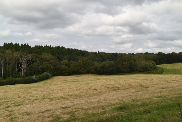
Beech Mead Wood is a picturesque woodland located in the county of Sussex, England. Covering an area of approximately 50 hectares, it is nestled within the South Downs National Park, offering visitors a tranquil escape from the bustling city life. The wood is predominantly made up of beech trees, which provide a dense canopy of foliage and create a serene and shaded environment.

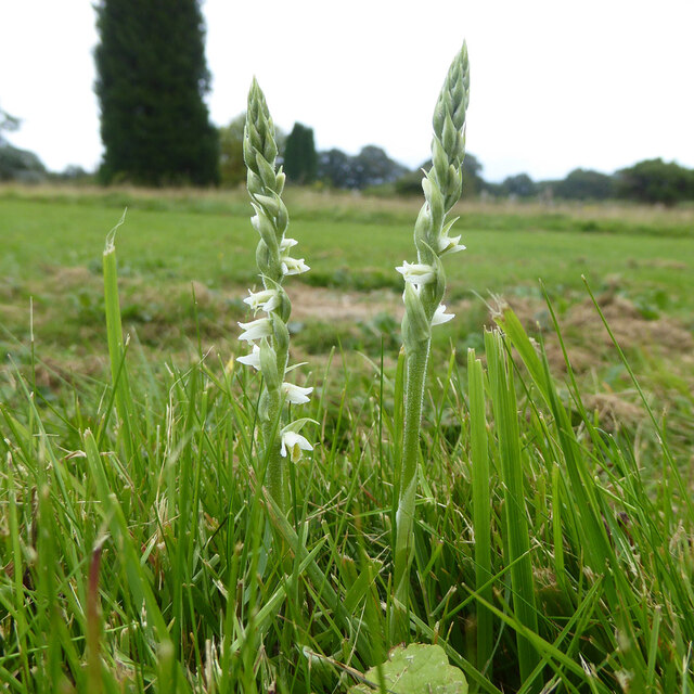
As visitors explore Beech Mead Wood, they will encounter a diverse range of flora and fauna. The forest floor is adorned with an array of wildflowers, including bluebells and primroses, which bloom in the spring months, creating a stunning carpet of colors. The wood is also home to a variety of wildlife, including deer, badgers, foxes, and numerous species of birds, making it a popular spot for birdwatchers and nature enthusiasts.

The wood is crisscrossed with a network of well-maintained footpaths and trails, which make it easily accessible for walkers and hikers of all abilities. These paths meander through the ancient woodland, allowing visitors to fully immerse themselves in the natural beauty of their surroundings. There are also several picnic areas dotted throughout the wood, providing the perfect opportunity for visitors to relax and enjoy a packed lunch amidst the peaceful ambiance.

Beech Mead Wood is not only a haven for wildlife and nature lovers but also a valuable resource for environmental education and conservation. The wood is managed by a local conservation organization, which works tirelessly to preserve the wood's natural habitats and promote sustainable practices.

Overall, Beech Mead Wood offers a serene and enchanting experience for visitors, with its ancient beech trees, diverse wildlife, and well-maintained trails. It is a place where one can escape the hustle and bustle of modern life and reconnect with nature's beauty.

If you have any feedback on the listing, please let us know in the comments section below.

Beech Mead Wood Images

Images are sourced within 2km of 51.00257/-0.062986482 or Grid Reference TQ3624. Thanks to Geograph Open Source API. All images are credited.

Autumn Lady's-tresses, Walstead Cemetery Spiranthes spiralis is the last orchid of the season. Largely confined to southern England in the UK, this small orchid grows in short grass, usually on chalk or limestone.  Away from these, churchyards and not too recently mown dry lawns are worth searching.
Autumn Lady's-tresses, Walstead Cemetery
Spiranthes spiralis is the last orchid of the season. Largely confined to southern England in the UK, this small orchid grows in short grass, usually on chalk or limestone. Away from these, churchyards and not too recently mown dry lawns are worth searching.
Lindfield Pond When the fountain was working.
Lindfield Pond
When the fountain was working.
Lindfield Pond When the fountain was working, and people were feeding the ducks.
Lindfield Pond
When the fountain was working, and people were feeding the ducks.
Sussex Border Path The Sussex Border Path is a footpath route nearly 150 miles long around the inland boundary of the county of Sussex. The county owes its origins to the kingdom of the South Saxons and can claim to have one of the longest inland county boundaries from Emsworth to Rye. The route was devised in 1983 and is well signed along most of the route. Website <span class="nowrap"><a title="http://www.sussexborderpath.co.uk/" rel="nofollow ugc noopener" href="http://www.sussexborderpath.co.uk/">Link</a><img style="margin-left:2px;" alt="External link" title="External link - shift click to open in new window" src="https://s1.geograph.org.uk/img/external.png" width="10" height="10"/></span> 
Map: <a title="https://www.geograph.org.uk/search.php?i=40140109&page=1&displayclass=map#i=40140109&page=1&displayclass=map&zoom=2&lat=51.03263&lon=-0.05427&layers=FTTB00000000000T" href="https://www.geograph.org.uk/search.php?i=40140109&page=1&displayclass=map#i=40140109&page=1&displayclass=map&zoom=2&lat=51.03263&lon=-0.05427&layers=FTTB00000000000T">Link</a>
Sussex Border Path
The Sussex Border Path is a footpath route nearly 150 miles long around the inland boundary of the county of Sussex. The county owes its origins to the kingdom of the South Saxons and can claim to have one of the longest inland county boundaries from Emsworth to Rye. The route was devised in 1983 and is well signed along most of the route. Website LinkExternal link Map: Link
Ham Lane
Ham Lane
Ham Lane
Ham Lane
Five Oaks Wood
Five Oaks Wood
Five Oaks Wood and farmland
Ham Lane The Sussex Border Path is a footpath route nearly 150 miles long around the inland boundary of the county of Sussex. The county owes its origins to the kingdom of the South Saxons and can claim to have one of the longest inland county boundaries from Emsworth to Rye. The route was devised in 1983 and is well signed along most of the route. Website <span class="nowrap"><a title="http://www.sussexborderpath.co.uk/" rel="nofollow ugc noopener" href="http://www.sussexborderpath.co.uk/">Link</a><img style="margin-left:2px;" alt="External link" title="External link - shift click to open in new window" src="https://s1.geograph.org.uk/img/external.png" width="10" height="10"/></span> 
Map: <a title="https://www.geograph.org.uk/search.php?i=40140109&page=1&displayclass=map#i=40140109&page=1&displayclass=map&zoom=2&lat=51.03263&lon=-0.05427&layers=FTTB00000000000T" href="https://www.geograph.org.uk/search.php?i=40140109&page=1&displayclass=map#i=40140109&page=1&displayclass=map&zoom=2&lat=51.03263&lon=-0.05427&layers=FTTB00000000000T">Link</a>
Ham Lane
The Sussex Border Path is a footpath route nearly 150 miles long around the inland boundary of the county of Sussex. The county owes its origins to the kingdom of the South Saxons and can claim to have one of the longest inland county boundaries from Emsworth to Rye. The route was devised in 1983 and is well signed along most of the route. Website LinkExternal link Map: Link
Ham Lane
Ham Lane
Ham Lane
Ham Lane
Ham Lane The Sussex Border Path is a footpath route nearly 150 miles long around the inland boundary of the county of Sussex. The county owes its origins to the kingdom of the South Saxons and can claim to have one of the longest inland county boundaries from Emsworth to Rye. The route was devised in 1983 and is well signed along most of the route. Website <span class="nowrap"><a title="http://www.sussexborderpath.co.uk/" rel="nofollow ugc noopener" href="http://www.sussexborderpath.co.uk/">Link</a><img style="margin-left:2px;" alt="External link" title="External link - shift click to open in new window" src="https://s1.geograph.org.uk/img/external.png" width="10" height="10"/></span> 
Map: <a title="https://www.geograph.org.uk/search.php?i=40140109&page=1&displayclass=map#i=40140109&page=1&displayclass=map&zoom=2&lat=51.03263&lon=-0.05427&layers=FTTB00000000000T" href="https://www.geograph.org.uk/search.php?i=40140109&page=1&displayclass=map#i=40140109&page=1&displayclass=map&zoom=2&lat=51.03263&lon=-0.05427&layers=FTTB00000000000T">Link</a>
Ham Lane
The Sussex Border Path is a footpath route nearly 150 miles long around the inland boundary of the county of Sussex. The county owes its origins to the kingdom of the South Saxons and can claim to have one of the longest inland county boundaries from Emsworth to Rye. The route was devised in 1983 and is well signed along most of the route. Website LinkExternal link Map: Link
Eastlands Farm
Eastlands Farm
Ham Lane Farm
Ham Lane Farm
Ham Lane The Sussex Border Path is a footpath route nearly 150 miles long around the inland boundary of the county of Sussex. The county owes its origins to the kingdom of the South Saxons and can claim to have one of the longest inland county boundaries from Emsworth to Rye. The route was devised in 1983 and is well signed along most of the route. Website <span class="nowrap"><a title="http://www.sussexborderpath.co.uk/" rel="nofollow ugc noopener" href="http://www.sussexborderpath.co.uk/">Link</a><img style="margin-left:2px;" alt="External link" title="External link - shift click to open in new window" src="https://s1.geograph.org.uk/img/external.png" width="10" height="10"/></span> 
Map: <a title="https://www.geograph.org.uk/search.php?i=40140109&page=1&displayclass=map#i=40140109&page=1&displayclass=map&zoom=2&lat=51.03263&lon=-0.05427&layers=FTTB00000000000T" href="https://www.geograph.org.uk/search.php?i=40140109&page=1&displayclass=map#i=40140109&page=1&displayclass=map&zoom=2&lat=51.03263&lon=-0.05427&layers=FTTB00000000000T">Link</a>
Ham Lane
The Sussex Border Path is a footpath route nearly 150 miles long around the inland boundary of the county of Sussex. The county owes its origins to the kingdom of the South Saxons and can claim to have one of the longest inland county boundaries from Emsworth to Rye. The route was devised in 1983 and is well signed along most of the route. Website LinkExternal link Map: Link
Ham Lane
Ham Lane
Ham Lane
Ham Lane
Show me another place!

Beech Mead Wood is located at Grid Ref: TQ3624 (Lat: 51.00257, Lng: -0.062986482)

Administrative County: West Sussex

District: Mid Sussex

Police Authority: Sussex

What 3 Words

///portable.notice.iterative. Near Haywards Heath, West Sussex

Related Wikis

Lindfield Rural

Lindfield Rural is a civil parish in the Mid Sussex District of West Sussex, England. It is located on the southern slopes of the Weald, five miles (8...

Walstead

Walstead is a hamlet located 1.5 kilometres (0.93 mi) south east of Lindfield, West Sussex, England. The hamlet is the home of Great Walstead School, Paxhill...

Great Walstead School

Great Walstead School is a private day school for girls and boys between the ages of 2½ and 13 years with a Christian ethos. It has some 400 children in...

Eastern Road Nature Reserve

Eastern Road Nature Reserve is a 3.5-hectare (8.6-acre) Local Nature Reserve on the eastern outskirts of Haywards Heath in West Sussex. It is owned and...

Nearby Amenities

Located within 500m of 51.00257,-0.062986482
Barrier: stile
Lat/Long: 51.0033604/-0.0592025
Barrier: kissing_gate
Lat/Long: 51.0018786/-0.0578675
Barrier: stile
Lat/Long: 51.0048853/-0.0604081
Barrier: stile
Lat/Long: 51.0058469/-0.0616014
Barrier: stile
Stile: squeezer
Lat/Long: 51.0058484/-0.0617277
Barrier: stile
Lat/Long: 51.0014105/-0.0584894
Barrier: kissing_gate
Lat/Long: 51.0011053/-0.0652546
Addr City: Haywards Heath
Addr Housename: Walstead Place Cottages
Addr Postcode: RH16 2QG
Addr Street: Scaynes Hill Road
Addr Suburb: Lindfield
Lat/Long: 51.0039545/-0.0691232
Addr City: Haywards Heath
Addr Housename: Walstead Manor Cottages
Addr Postcode: RH16 2QG
Addr Street: Scaynes Hill Road
Addr Suburb: Lindfield
Lat/Long: 51.0009256/-0.0655438
Power: pole
Lat/Long: 51.0012995/-0.0593329
Power: pole
Lat/Long: 51.0018188/-0.0601748
Power: pole
Lat/Long: 51.0014836/-0.0626278
Power: pole
Lat/Long: 51.0012764/-0.0638876
Power: pole
Lat/Long: 51.0001956/-0.0576399
Power: pole
Lat/Long: 51.0007441/-0.058481
Power: pole
Lat/Long: 51.0016505/-0.0614847
Power: pole
Lat/Long: 51.0010763/-0.0643223
Power: pole
Lat/Long: 51.0009525/-0.0648281
Barrier: stile
Lat/Long: 51.0017532/-0.0601292
The data included in this document is from www.openstreetmap.org. The data is made available under ODbL.

Have you been to Beech Mead Wood?

Leave your review of Beech Mead Wood below (or comments, questions and feedback).