Eskgrove

Settlement in Midlothian

Scotland

Eskgrove

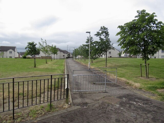
Road from Dalhousie Chesters
Road from Dalhousie Chesters Credit: Richard Webb

Eskgrove is a small village located in Midlothian, Scotland. Situated on the banks of the River Esk, it is surrounded by picturesque countryside and offers a tranquil and scenic setting.

The village is home to a close-knit community, with a population of approximately 500 residents. It is known for its friendly and welcoming atmosphere, reflecting the traditional Scottish hospitality. Eskgrove's residents take pride in their village and work together to maintain its charm and beauty.

The architecture in Eskgrove is predominantly traditional, with a mix of historic stone buildings and newer developments. The village has a small but convenient range of amenities, including a local shop, a post office, and a primary school, making it an ideal place for families. For additional services and amenities, the larger town of Dalkeith is just a short drive away.

Outdoor enthusiasts will find plenty to enjoy in Eskgrove, with its proximity to the beautiful Scottish countryside. The River Esk offers opportunities for fishing and boating, while the surrounding hills and woodlands provide ample space for walking, cycling, and wildlife spotting.

Eskgrove has good transport links, with regular bus services connecting it to nearby towns and cities. The village also benefits from its proximity to the A1 road, making it easily accessible for those commuting to Edinburgh or other parts of Scotland.

Overall, Eskgrove is a charming and idyllic village, offering a quiet and peaceful lifestyle in a beautiful Scottish setting.

If you have any feedback on the listing, please let us know in the comments section below.

Eskgrove Images

Images are sourced within 2km of 55.872911/-3.1362537 or Grid Reference NT2965. Thanks to Geograph Open Source API. All images are credited.

Road from Dalhousie Chesters
Auld Coal Terrace New houses seen from Burnbank Park, the site of Polton Colliery.  The Pittendriech Burn flows under the park through a culvert.
Auld Coal Terrace
New houses seen from Burnbank Park, the site of Polton Colliery. The Pittendriech Burn flows under the park through a culvert.
Burn under Burnbank Park The Pittendriech Burn runs through a culvert under a park built with colliery waste.
Burn under Burnbank Park
The Pittendriech Burn runs through a culvert under a park built with colliery waste.
Bridge over the Pittendriech Burn New houses on the edge of Bonnyrigg. The burn runs under the colliery waste of Burnbank Park.
Bridge over the Pittendriech Burn
New houses on the edge of Bonnyrigg. The burn runs under the colliery waste of Burnbank Park.
Path beside the Pittendriech Burn An icy path heading for nowhere - well a very muddy informal path into Little Wood. The message is clear - more houses to come.
Path beside the Pittendriech Burn
An icy path heading for nowhere - well a very muddy informal path into Little Wood. The message is clear - more houses to come.
Building in Little Wood The current edge of Bonnyrigg. There was once a reservoir in the wood, presumably connected with the nearby Polton Colliery.
Building in Little Wood
The current edge of Bonnyrigg. There was once a reservoir in the wood, presumably connected with the nearby Polton Colliery.
Field near Dalhousie Chesters Very much in the sights of the developers.
Field near Dalhousie Chesters
Very much in the sights of the developers.
Field near Dalhousie Chesters Very much in the sights of the developers.
Field near Dalhousie Chesters
Very much in the sights of the developers.
Field near Dalhousie Chesters One of the surviving fields within the Bonnyrigg Distributor Road.  For now.
Field near Dalhousie Chesters
One of the surviving fields within the Bonnyrigg Distributor Road. For now.
Track, Dalhousie Chesters Almost certain to be developed for housing.
Track, Dalhousie Chesters
Almost certain to be developed for housing.
Track, Dalhousie Chesters With boreholes nearby, it appears that this will one day be built up.
Track, Dalhousie Chesters
With boreholes nearby, it appears that this will one day be built up.
Winter cereals, Dalhousie Chesters Field on the edge of Bonnyrigg and within the distribution road so no doubt in the sights of the developers during this period of rapid urbanisation.
Winter cereals, Dalhousie Chesters
Field on the edge of Bonnyrigg and within the distribution road so no doubt in the sights of the developers during this period of rapid urbanisation.
Path, Bonnyrigg To the Auld Coal residential streets recently built to the south.
Path, Bonnyrigg
To the Auld Coal residential streets recently built to the south.
Penicuik to Musselburgh Path
Danger! The tar changed colour! Because the Heras did not block the road many people braved the hazardous colour.  (A section was resurfaced and the signs had not been fully removed)
Danger!
The tar changed colour! Because the Heras did not block the road many people braved the hazardous colour. (A section was resurfaced and the signs had not been fully removed)
Castell Maynes Crescent New houses by the rails to trails path, Bonnyrigg.
Castell Maynes Crescent
New houses by the rails to trails path, Bonnyrigg.
Penicuik to Musselburgh Path Passing Castell Maynes Crescent.
Penicuik to Musselburgh Path
Passing Castell Maynes Crescent.
Field, Dalhousie Chesters For how much longer? There are boreholes and it is within a bypass.
Field, Dalhousie Chesters
For how much longer? There are boreholes and it is within a bypass.
Show me another place!

Eskgrove is located at Grid Ref: NT2965 (Lat: 55.872911, Lng: -3.1362537)

Unitary Authority: Midlothian

Police Authority: The Lothians and Scottish Borders

What 3 Words

///track.eyelashes.traders. Near Loanhead, Midlothian

Nearby Locations

Eskgrove

Related Wikis

Mavisbank House

Mavisbank is a country house outside Loanhead, south of Edinburgh in Midlothian, Scotland. It was designed by architect William Adam in collaboration with...

Polton railway station

Polton railway station served the village of Polton, Midlothian, Scotland from 1867 to 1964 on the Esk Valley Railway. == History == The station opened...

Polton

Polton is a village located in Lasswade parish, Midlothian, Scotland, anciently a superiority of the Ramsay family, cadets of Dalhousie. In 1618 David...

Loanhead railway station

Loanhead railway station served the town of Loanhead, Midlothian, Scotland, from 1874 to 1968 on the Edinburgh, Loanhead and Roslin Railway. == History... ==

Nearby Amenities

Located within 500m of 55.872911,-3.1362537
Waterway: weir
Lat/Long: 55.8718974/-3.1378164
Post Box
Mapillary: 163748885682446
Operator: Royal Mail
Operator Type: private
Operator Wikidata: Q638098
Post Box Type: lamp
Ref: EH18 71
Lat/Long: 55.8711011/-3.1368797
Historic: memorial
Memorial: war_memorial
Lat/Long: 55.8714833/-3.1388893
Polton
Whitewater: egress
Lat/Long: 55.8713377/-3.1385536
Springfield Mill
Information: board
Tourism: information
Lat/Long: 55.8708328/-3.138272
Barrier: bollard
Lat/Long: 55.8708163/-3.1384788
Roman Fort
Historic: archaeological_site
Source: Survey
Lat/Long: 55.8734843/-3.1404489
Mavisbank
Board Type: history
Information: board
Tourism: information
Lat/Long: 55.87335/-3.13563
Bench
Lat/Long: 55.8759564/-3.1323253
Traffic Calming: cushion
Lat/Long: 55.8699898/-3.1306315
Give Way
Direction: backward
Lat/Long: 55.8700483/-3.1308355
Give Way
Direction: backward
Lat/Long: 55.8703743/-3.1303659
Location: outdoor
Power: substation
Substation: minor_distribution
Lat/Long: 55.8706813/-3.129458
Traffic Calming: cushion
Lat/Long: 55.8710092/-3.1293906
Give Way
Direction: backward
Lat/Long: 55.8710664/-3.1291987
The data included in this document is from www.openstreetmap.org. The data is made available under ODbL.

Have you been to Eskgrove?

Leave your review of Eskgrove below (or comments, questions and feedback).