Big Wood

Wood, Forest in Surrey

England

Big Wood

The Codfather Located in Woodmansterne.
The Codfather Credit: Peter Trimming

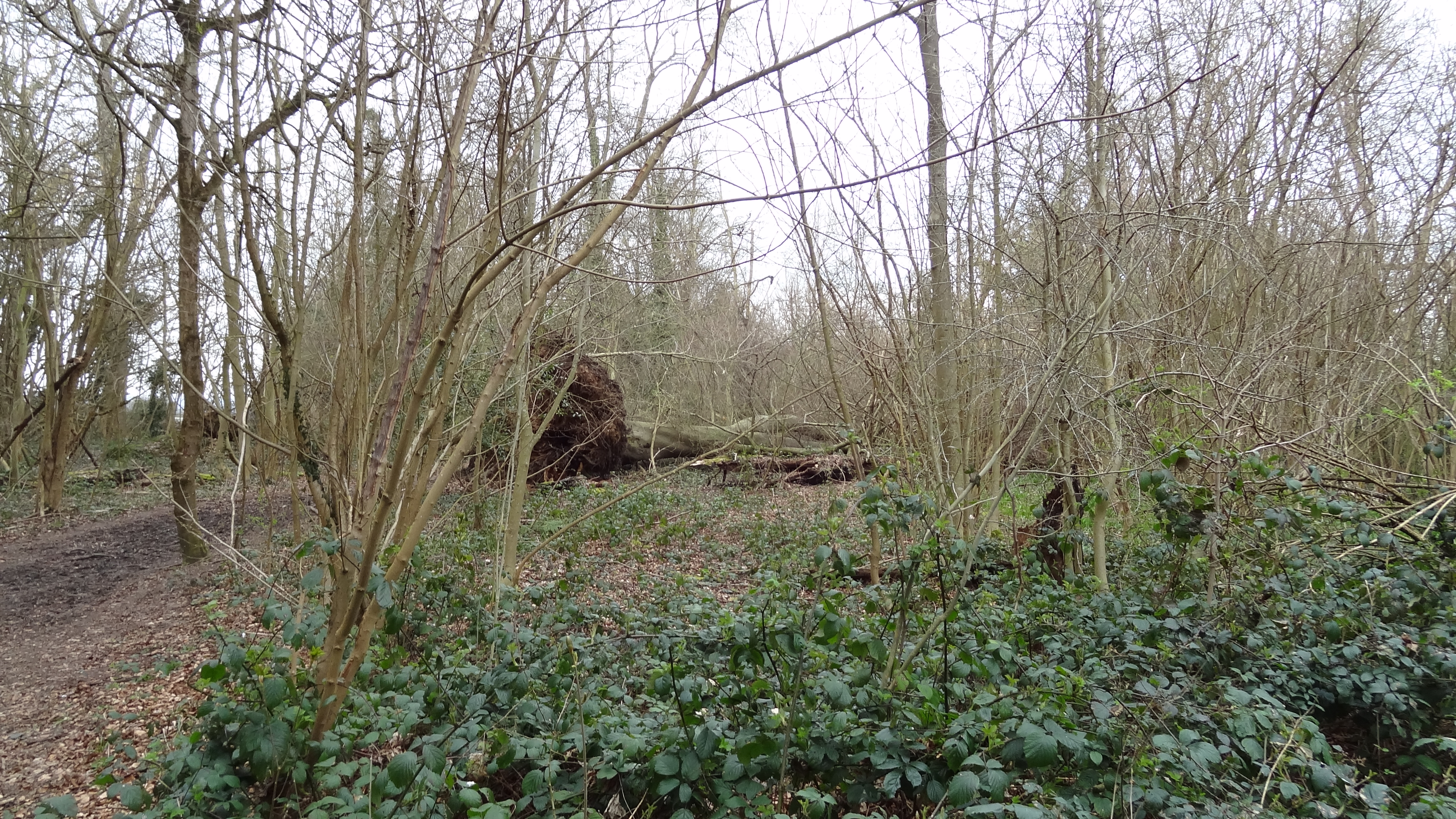
Big Wood is a picturesque woodland located in Surrey, England. It is nestled in the southern part of the county, near the village of Wood. This enchanting forest covers an area of approximately 100 acres and is renowned for its natural beauty and diverse wildlife.

The wood is primarily composed of deciduous trees, including oak, beech, and birch, which create a vibrant and ever-changing landscape throughout the seasons. The dense canopy provides a cool and shaded environment, making it a popular destination for nature lovers, hikers, and picnickers alike.

Big Wood offers a variety of well-maintained trails, allowing visitors to explore its enchanting surroundings. These paths meander through the woodland, offering glimpses of ancient trees, wildflowers, and ferns. The forest floor is carpeted with a rich layer of moss and fallen leaves, creating a serene and peaceful atmosphere.

The woodland is also home to a diverse range of wildlife, making it a haven for nature enthusiasts. Birdwatchers can spot various species, including woodpeckers, owls, and finches, while animal lovers may catch a glimpse of deer, foxes, and rabbits. The woodland provides a natural habitat for these creatures, ensuring their survival and preservation.

Big Wood is easily accessible, with ample parking facilities and well-marked entrances. It attracts visitors from far and wide, who come to enjoy the tranquility and natural beauty that this ancient woodland has to offer. Whether for a leisurely stroll, a family outing, or a peaceful escape from the hustle and bustle of everyday life, Big Wood is a hidden gem in the heart of Surrey.

If you have any feedback on the listing, please let us know in the comments section below.

Big Wood Images

Images are sourced within 2km of 51.328416/-0.16231055 or Grid Reference TQ2860. Thanks to Geograph Open Source API. All images are credited.

The Codfather Located in Woodmansterne.
The Codfather
Located in Woodmansterne.
Coulsdon Crawford Crescent, on the site of the former Cane Hill mental hospital. The water tower is one of just three buildings remaining from the hospital.
Coulsdon
Crawford Crescent, on the site of the former Cane Hill mental hospital. The water tower is one of just three buildings remaining from the hospital.
Coulsdon The site of the former Cane Hill mental hospital. The water tower is one of just three buildings remaining from the hospital. In the foreground is a small pond, surrounded by reeds.
Coulsdon
The site of the former Cane Hill mental hospital. The water tower is one of just three buildings remaining from the hospital. In the foreground is a small pond, surrounded by reeds.
Coulsdon : Cane Hill water tower Water tower of the former Cane Hill Asylum (later Mental Hospital), the history of which may be found at this <span class="nowrap"><a title="https://en.wikipedia.org/wiki/Cane_Hill_Hospital" rel="nofollow ugc noopener" href="https://en.wikipedia.org/wiki/Cane_Hill_Hospital">Link</a><img style="margin-left:2px;" alt="External link" title="External link - shift click to open in new window" src="https://s1.geograph.org.uk/img/external.png" width="10" height="10"/></span>.
Coulsdon : Cane Hill water tower
Water tower of the former Cane Hill Asylum (later Mental Hospital), the history of which may be found at this LinkExternal link.
Rectory Lane, Woodmansterne, near Banstead Rectory lane climbing out of Woodmansterne in Surrey.  This road forms part of the route of the B278.
Rectory Lane, Woodmansterne, near Banstead
Rectory lane climbing out of Woodmansterne in Surrey. This road forms part of the route of the B278.
Manor Way, Woodmansterne Manor Way is a residential road in Woodmansterne, in Surrey.
Manor Way, Woodmansterne
Manor Way is a residential road in Woodmansterne, in Surrey.
Chipstead Valley Road, Woodmansterne Chipstead Valley Road, on the outer fringe of south London, is on the route of the B2032.
Chipstead Valley Road, Woodmansterne
Chipstead Valley Road, on the outer fringe of south London, is on the route of the B2032.
Sandown Road, Woodmansterne Sandown Road in Woodmansterne, on the outer fringe of south London.  Here, the road passes beneath a bridge carrying a railway line before turning sharply to the right.
Sandown Road, Woodmansterne
Sandown Road in Woodmansterne, on the outer fringe of south London. Here, the road passes beneath a bridge carrying a railway line before turning sharply to the right.
St. Andrew's Road, Woodmansterne St. Andrew's Road is a residential road in Woodmansterne, on the outer fringe of south London.

This image was taken on a February afternoon.  At this time of year, the sun is low in the sky resulting in long shadows, while trees are bare for the winter season.
St. Andrew's Road, Woodmansterne
St. Andrew's Road is a residential road in Woodmansterne, on the outer fringe of south London. This image was taken on a February afternoon. At this time of year, the sun is low in the sky resulting in long shadows, while trees are bare for the winter season.
Winifred Road, Coulsdon Winifred Road is a residential road in Coulsdon, in the outer suburbs of south London.  The houses are built on a hillside, thus they stand at a higher level than the road.
Winifred Road, Coulsdon
Winifred Road is a residential road in Coulsdon, in the outer suburbs of south London. The houses are built on a hillside, thus they stand at a higher level than the road.
Alexander Road, Coulsdon Alexander Road is a residential road on a hillside in Coulsdon, in the outer suburbs of south London.

This image was taken on a sunny February afternoon.  At this time of year, the sun is low in the sky, resulting in long shadows.
Alexander Road, Coulsdon
Alexander Road is a residential road on a hillside in Coulsdon, in the outer suburbs of south London. This image was taken on a sunny February afternoon. At this time of year, the sun is low in the sky, resulting in long shadows.
Winter trees on Woodmansterne Road, Coulsdon Trees on Woodmansterne Road, a residential road in Coulsdon in the outer suburbs of south London.

This image was taken on a February afternoon.  Trees were bare for the winter months.  The sun was low in the sky, resulting in long shadows.
Winter trees on Woodmansterne Road, Coulsdon
Trees on Woodmansterne Road, a residential road in Coulsdon in the outer suburbs of south London. This image was taken on a February afternoon. Trees were bare for the winter months. The sun was low in the sky, resulting in long shadows.
Bramley Avenue, Coulsdon Bramley Avenue is a tree-lined residential road in Coulsdon, in the outer suburbs of south London.  A 20 mph speed limit applies, and the road has speed cushions as a traffic-calming measure.

This image was taken on a February afternoon, when most of the trees were bare for the winter season.
Bramley Avenue, Coulsdon
Bramley Avenue is a tree-lined residential road in Coulsdon, in the outer suburbs of south London. A 20 mph speed limit applies, and the road has speed cushions as a traffic-calming measure. This image was taken on a February afternoon, when most of the trees were bare for the winter season.
Southwood Avenue, Coulsdon Southwood Avenue is a residential road on a hillside in Coulsdon, on the outer fringe of south London.

This image was taken on a February afternoon.  Most of the trees were bare for the winter season, although the tree to the left of the road is an evergreen.
Southwood Avenue, Coulsdon
Southwood Avenue is a residential road on a hillside in Coulsdon, on the outer fringe of south London. This image was taken on a February afternoon. Most of the trees were bare for the winter season, although the tree to the left of the road is an evergreen.
Northern end of Coulsdon Inner Relief Road Seven years of devastation has been endured and sixteen perfectly good houses demolished in order to create this traffic jam.  To see a picture from almost the same viewpoint taken four years earlier, in 2003 <a href="https://www.geograph.org.uk/photo/54359">TQ3059 : Demolition of 8, Windermere Road, Coulsdon, Surrey</a>
Northern end of Coulsdon Inner Relief Road
Seven years of devastation has been endured and sixteen perfectly good houses demolished in order to create this traffic jam. To see a picture from almost the same viewpoint taken four years earlier, in 2003 TQ3059 : Demolition of 8, Windermere Road, Coulsdon, Surrey
'Shopper's Car Park', Coulsdon After lying completely empty and disused for over seven years, Croydon Council decided in 2002 to open this patch of ground as a 'Shopper's Car Park'.  The extent of its use can be judged from the photograph. The two pairs of semis. between this ground and the church were demolished in 2003.
'Shopper's Car Park', Coulsdon
After lying completely empty and disused for over seven years, Croydon Council decided in 2002 to open this patch of ground as a 'Shopper's Car Park'. The extent of its use can be judged from the photograph. The two pairs of semis. between this ground and the church were demolished in 2003.
Houses to go, Brighton Road, Coulsdon These two pairs of semis. were demolished in 2003 to make way for the Coulsdon Inner Relief Road.
Houses to go, Brighton Road, Coulsdon
These two pairs of semis. were demolished in 2003 to make way for the Coulsdon Inner Relief Road.
North end of Coulsdon Inner Relief Road After a light powdering of snow.  This traffic is southbound.  The bus will turn right to serve Coulsdon Town Centre, while the other traffic will use the bypass to avoid the centre.
North end of Coulsdon Inner Relief Road
After a light powdering of snow. This traffic is southbound. The bus will turn right to serve Coulsdon Town Centre, while the other traffic will use the bypass to avoid the centre.
Show me another place!

Big Wood is located at Grid Ref: TQ2860 (Lat: 51.328416, Lng: -0.16231055)

Unitary Authority: Sutton

Police Authority: Metropolitan

What 3 Words

///oldest.views.kinks. Near Coulsdon, London

Nearby Locations

Clock House Big Wood

Related Wikis

Ruffett and Big Woods

Ruffett Wood and Big Wood are adjoining woods with a total area of 7 hectares (17 acres) on the border of the London Borough of Sutton, close to the village...

Oaks Park (London)

Oaks Park is a public park in Carshalton in the London Borough of Sutton. It is bounded on the south by Croydon Lane (A2022), and on the east by Woodmansterne...

Little Woodcote

Little Woodcote is an area in the London Borough of Sutton, and also in the London Borough of Croydon and it is located in the south-east of the borough...

Woodmansterne

Woodmansterne is a village in the borough of Reigate and Banstead, Surrey, bordering Greater London, England. It sits on a small plateau of and a southern...

Woodmansterne railway station

Woodmansterne railway station is a railway station which primarily serves the western areas of Coulsdon in the London Borough of Croydon, England. Situated...

Woodcote High School

Woodcote High School is a secondary school with academy status located in the Coulsdon area of the London Borough of Croydon, England. Woodcote is a coeducational...

Chipstead, Surrey

Chipstead is a predominantly commuter village in north-east Surrey, England, that has been a small ecclesiastical parish since the Domesday Survey of 1086...

Coulsdon

Coulsdon (, traditionally pronounced ), is a town in south London, England, within the London Borough of Croydon. Coulsdon was an ancient parish in the...

Nearby Amenities

Located within 500m of 51.328416,-0.16231055
Barrier: bollard
Lat/Long: 51.3266429/-0.1611316
Clockhouse
Is In: Sutton, Greater London, UK
Place: neighbourhood
Lat/Long: 51.3260695/-0.1568827
Turning Circle
Source: Bing
Lat/Long: 51.3262977/-0.1560032
Barrier: bollard
Lat/Long: 51.3264192/-0.1608475
Barrier: bollard
Lat/Long: 51.3317076/-0.1595446
Barrier: bollard
Lat/Long: 51.3320662/-0.1603513
Addr City: Coulsdon
Addr Housenumber: 177
Addr Postcode: CR5 2QF
Addr Street: Grove Lane
Source: codepoint;survey
Lat/Long: 51.328219/-0.1559777
Addr City: Coulsdon
Addr Housenumber: 5
Addr Postcode: CR5 2QY
Addr Street: Longlands Avenue
Source: codepoint;survey
Lat/Long: 51.3267161/-0.1562626
Addr City: Coulsdon
Addr Housenumber: 14
Addr Postcode: CR5 2QH
Addr Street: Downland Close
Source: codepoint;survey
Lat/Long: 51.3266665/-0.1560385
Addr City: Coulsdon
Addr Housenumber: 23
Addr Postcode: CR5 2QY
Addr Street: Longlands Avenue
Source: codepoint;survey
Lat/Long: 51.3265411/-0.1572527
Addr City: Coulsdon
Addr Housenumber: 28
Addr Postcode: CR5 2QJ
Addr Street: Longlands Avenue
Source: codepoint;survey
Lat/Long: 51.3270459/-0.1563654
Addr City: Coulsdon
Addr Housenumber: 28a
Addr Postcode: CR5 2QJ
Addr Street: Longlands Avenue
Source: codepoint;survey
Lat/Long: 51.3270634/-0.1564494
Addr City: Coulsdon
Addr Housenumber: 1a
Addr Postcode: CR5 2QR
Addr Street: June Close
Source: codepoint;survey
Lat/Long: 51.3273326/-0.1560007
Addr City: Coulsdon
Addr Housenumber: 1
Addr Postcode: CR5 2QR
Addr Street: June Close
Source: codepoint;survey
Lat/Long: 51.3274189/-0.1560608
Addr City: Coulsdon
Addr Housenumber: 18
Addr Postcode: CR5 2QR
Addr Street: June Close
Source: codepoint;survey
Lat/Long: 51.3274166/-0.1570164
Addr City: Coulsdon
Addr Housenumber: 30a
Addr Postcode: CR5 2QG
Addr Street: Longlands Avenue
Source: codepoint;survey
Lat/Long: 51.3270893/-0.1566696
Addr City: Coulsdon
Addr Housenumber: 30
Addr Postcode: CR5 2QG
Addr Street: Longlands Avenue
Source: codepoint;survey
Lat/Long: 51.3271026/-0.1567474
Addr City: Coulsdon
Addr Housenumber: 30
Addr Postcode: CR5 2QG
Addr Street: Longlands Avenue
Source: codepoint;survey
Lat/Long: 51.3262865/-0.1603503
Addr City: Coulsdon
Addr Housenumber: 25
Addr Postcode: CR5 2QZ
Addr Street: Longlands Avenue
Source: codepoint;survey
Lat/Long: 51.3263241/-0.1578198
Addr City: Coulsdon
Addr Housenumber: 51
Addr Postcode: CR5 2QZ
Addr Street: Longlands Avenue
Source: codepoint;survey
Lat/Long: 51.3260565/-0.1599185
Addr City: Coulsdon
Addr Housenumber: 18
Addr Postcode: CR5 2QS
Addr Street: Lloyd Avenue
Source: codepoint;survey
Lat/Long: 51.3261627/-0.1576995
Addr City: Coulsdon
Addr Housenumber: 19
Addr Postcode: CR5 2QS
Addr Street: Lloyd Avenue
Source: codepoint;survey
Lat/Long: 51.3262556/-0.1572606
Addr City: Coulsdon
Addr Housenumber: 14
Addr Postcode: CR5 2QS
Addr Street: Lloyd Avenue
Source: codepoint;survey
Lat/Long: 51.3260521/-0.1575933
Addr City: Coulsdon
Addr Housenumber: 2
Addr Postcode: CR5 2QS
Addr Street: Lloyd Avenue
Source: codepoint;survey
Lat/Long: 51.3254948/-0.1569881
Addr City: Coulsdon
Addr Housenumber: 12
Addr Postcode: CR5 2QS
Addr Street: Lloyd Avenue
Source: codepoint;survey
Lat/Long: 51.3258752/-0.1574305
Addr City: Coulsdon
Addr Housenumber: 1
Addr Postcode: CR5 2QX
Addr Street: Pembury Close
Source: codepoint;survey
Lat/Long: 51.3254904/-0.1574446
Addr City: Coulsdon
Addr Housenumber: 20
Addr Postcode: CR5 2QX
Addr Street: Pembury Close
Source: codepoint;survey
Lat/Long: 51.3259194/-0.1578941
Addr City: Coulsdon
Addr Housenumber: 2
Addr Postcode: CR5 2QW
Addr Street: Richland Avenue
Source: codepoint;survey
Lat/Long: 51.3247893/-0.1584922
Addr City: Coulsdon
Addr Housenumber: 38
Addr Postcode: CR5 2QW
Addr Street: Richland Avenue
Source: codepoint;survey
Lat/Long: 51.3258177/-0.1597628
Addr City: Coulsdon
Addr Housenumber: 1
Addr Postcode: CR5 2QU
Addr Street: Richland Avenue
Source: codepoint;survey
Lat/Long: 51.3252648/-0.1597947
Addr City: Coulsdon
Addr Housenumber: 2
Addr Postcode: CR5 2QW
Addr Street: Richland Avenue
Source: codepoint;survey
Lat/Long: 51.3262733/-0.1609308
Addr City: Coulsdon
Addr Housenumber: 13
Addr Postcode: CR5 2QP
Addr Street: Corrigan Avenue
Source: codepoint;survey
Lat/Long: 51.3250281/-0.1593947
Addr City: Coulsdon
Addr Housenumber: 7
Addr Postcode: CR5 2QP
Addr Street: Corrigan Avenue
Source: codepoint;survey
Lat/Long: 51.3247893/-0.1591222
Addr City: Coulsdon
Addr Housenumber: 12
Addr Postcode: CR5 2QP
Addr Street: Corrigan Avenue
Source: codepoint;survey
Lat/Long: 51.3245858/-0.1595646
Addr City: Coulsdon
Addr Housenumber: 18
Addr Postcode: CR5 2QP
Addr Street: Corrigan Avenue
Source: codepoint;survey
Lat/Long: 51.324818/-0.1598655
Barrier: kissing_gate
Lat/Long: 51.3261567/-0.1637605
Walcountians Sports Club
Addr City: Woodmansterne
Addr Housename: Clockhouse Ground
Addr Postcode: SM7 3HU
Addr Street: Carshalton Road
Club: sport
Website: https://www.walcountianssportsclub.co.uk/
Lat/Long: 51.3287532/-0.1686178
The data included in this document is from www.openstreetmap.org. The data is made available under ODbL.

Have you been to Big Wood?

Leave your review of Big Wood below (or comments, questions and feedback).