Marymead Spring

Wood, Forest in Hertfordshire Stevenage

England

Marymead Spring

Knebworth Station Just to confirm that one exists
Knebworth Station Credit: Jack Hill

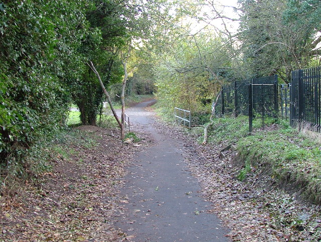
Marymead Spring is a picturesque woodland located in Hertfordshire, England. Covering an area of approximately 50 acres, it is situated in the heart of the county, making it easily accessible to locals and visitors alike. The woodland is named after the natural spring that flows through it, adding to its charm and tranquility.

As one enters Marymead Spring, they are greeted by a diverse range of tree species, including oak, ash, and beech, creating a lush and vibrant canopy overhead. The forest floor is adorned with a rich carpet of wildflowers, ferns, and mosses, making it a haven for nature enthusiasts and photographers.

The woodland is a haven for wildlife, providing a habitat for a variety of species. Many birds, such as woodpeckers, owls, and warblers, can be observed and heard throughout the year. Squirrels scamper amongst the branches, while deer and foxes can occasionally be spotted. The biodiversity of Marymead Spring has earned it recognition as a Site of Special Scientific Interest, highlighting its ecological importance.

There are several walking trails within Marymead Spring, allowing visitors to explore the woodland at their own pace. These well-maintained paths lead to various points of interest, including a small pond and a clearing with benches, perfect for picnics or simply taking in the natural beauty.

Overall, Marymead Spring offers a peaceful and enchanting escape from the hustle and bustle of everyday life. Its stunning woodland, diverse wildlife, and tranquil atmosphere make it a must-visit destination for nature lovers and those seeking a serene retreat in Hertfordshire.

If you have any feedback on the listing, please let us know in the comments section below.

Marymead Spring Images

Images are sourced within 2km of 51.881226/-0.18053568 or Grid Reference TL2521. Thanks to Geograph Open Source API. All images are credited.

Knebworth Station Just to confirm that one exists
Knebworth Station
Just to confirm that one exists
Knebworth   Reformed Church The banner at least will perpetuate a sentiment
Knebworth Reformed Church
The banner at least will perpetuate a sentiment
Hydean Way Shops Typical of local shops in Stevenage new town.  Above a parade of shops including a small supermarket, take away food outlet and Post Office there are maisonettes accessed from the rear.  To the right there are 2/3 bedroomed homes.
Hydean Way Shops
Typical of local shops in Stevenage new town. Above a parade of shops including a small supermarket, take away food outlet and Post Office there are maisonettes accessed from the rear. To the right there are 2/3 bedroomed homes.
South end of Fairlands Valley Park. This photograph was taken facing north into Fairlands Valley Park from the car park used for Stevenage Borough FC (see TL2422).  This park is also used for travelling fairs and circuses.
South end of Fairlands Valley Park.
This photograph was taken facing north into Fairlands Valley Park from the car park used for Stevenage Borough FC (see TL2422). This park is also used for travelling fairs and circuses.
Stevenage Borough FC Taken from the club's car park across the Hertford Road.
Stevenage Borough FC
Taken from the club's car park across the Hertford Road.
Novotel / Knebworth Park. Just off the A1(M) this is at the entrance of Knebworth Park home to "rock concerts through the ages".  The hotel has a helipad in its grounds.  Better access that by A1(M)
Novotel / Knebworth Park.
Just off the A1(M) this is at the entrance of Knebworth Park home to "rock concerts through the ages". The hotel has a helipad in its grounds. Better access that by A1(M)
Garden Shed perhaps at Deard's End Lane, Knebworth The incredibly close nature of the timber uprights is very unusual.
Garden Shed perhaps at Deard's End Lane, Knebworth
The incredibly close nature of the timber uprights is very unusual.
Unusual  double gable end to house in  Park Lane Knebworth Was it once a group of back to back houses?
Unusual double gable end to house in Park Lane Knebworth
Was it once a group of back to back houses?
Harwood Park Crematorium. I took this photograph just before attending a funeral here.  Note the blue sky.  Within 20 minutes the sky was black, it started thundering and hailing - just as the congregation started on "morning has broken".  Just like a scene from "The Exorsist or The Omen.
Harwood Park Crematorium.
I took this photograph just before attending a funeral here. Note the blue sky. Within 20 minutes the sky was black, it started thundering and hailing - just as the congregation started on "morning has broken". Just like a scene from "The Exorsist or The Omen.
Ridlins Athletics Track This photo of the Ridlins Athletics track shows the west corner and the Bert Hill stand.  The back of the stand has space for community groups such as playgroups.
Ridlins Athletics Track
This photo of the Ridlins Athletics track shows the west corner and the Bert Hill stand. The back of the stand has space for community groups such as playgroups.
Football pitches These are to the north west of the running track.
Football pitches
These are to the north west of the running track.
Footbridge over Stevenage Brook. This footpath runs parallel to and within 30 yards of the main Stevenage - Hertford Road.
Footbridge over Stevenage Brook.
This footpath runs parallel to and within 30 yards of the main Stevenage - Hertford Road.
Shops in Kenilworth Close. Supermarket, newsagent, Chinese takeaway and alternative therapist.
Shops in Kenilworth Close.
Supermarket, newsagent, Chinese takeaway and alternative therapist.
Church of St Peter, Broadwater. One of a series of three photos taken from within a couple of hundred yards of each other.  Church shops and flats.  A whole community?
Church of St Peter, Broadwater.
One of a series of three photos taken from within a couple of hundred yards of each other. Church shops and flats. A whole community?
Flats on Broadwater Avenue Most housing in this area consists of two storey houses but there are a number of blocks of flats like this.
Flats on Broadwater Avenue
Most housing in this area consists of two storey houses but there are a number of blocks of flats like this.
Broadwater Avenue shops Very busy local shops in the same style as several other Stevenage neighbourhood centres.
Broadwater Avenue shops
Very busy local shops in the same style as several other Stevenage neighbourhood centres.
Longmeadow Evangelical Church Many of Stevenage's churche seem to thrive and this is one of them.
Longmeadow Evangelical Church
Many of Stevenage's churche seem to thrive and this is one of them.
Knebworth telephone exchange With a modern extension on the back.
Knebworth telephone exchange
With a modern extension on the back.
Show me another place!

Marymead Spring is located at Grid Ref: TL2521 (Lat: 51.881226, Lng: -0.18053568)

Administrative County: Hertfordshire

District: Stevenage

Police Authority: Hertfordshire

What 3 Words

///take.fresh.image. Near Knebworth, Hertfordshire

Nearby Locations

Marymead Spring

Related Wikis

Shephall Manor

Shephall Manor, also known as Shephalbury Manor, is a Grade II listed building in Stevenage, a town in Hertfordshire, England. The house was designed by...

Marx Memorial Library

The Marx Memorial Library in London, United Kingdom is a library, archive, educational, and community outreach charity focused on Marxist and wider socialist...

Stevenage (UK Parliament constituency)

Stevenage is a constituency in Hertfordshire represented in the House of Commons of the UK Parliament since 2010 by Stephen McPartland, a member of the...

The Heathcote School

The Heathcote School was an 11-18 comprehensive school in Stevenage, Hertfordshire. The school was founded in the 1950s. It was awarded Specialist Engineering...

Shephall

Shephall (SHEP-all) is a neighbourhood of the new town of Stevenage in Hertfordshire. It was formerly a separate village and parish, being absorbed into...

Ridlins Mire

Ridlins Mire is a 1.6-hectare (4.0-acre) nature reserve managed by the Herts and Middlesex Wildlife Trust in Stevenage, Hertfordshire, England.This wetland...

Barnwell School

Barnwell School is a coeducational secondary school and sixth form that was established in 1959 and is situated in the south of Stevenage, Hertfordshire...

Broadhall Way

Broadhall Way, known as the Lamex Stadium for sponsorship purposes, is an association football stadium in Stevenage, Hertfordshire. It has been the home...

Nearby Amenities

Located within 500m of 51.881226,-0.18053568
Traffic Calming: cushion
Lat/Long: 51.8797852/-0.1850468
Traffic Calming: cushion
Lat/Long: 51.8791004/-0.1827796
Traffic Calming: cushion
Lat/Long: 51.8775224/-0.1766349
Traffic Calming: cushion
Lat/Long: 51.8824249/-0.1825518
Mini Roundabout
Direction: clockwise
Lat/Long: 51.8820019/-0.1800035
Mini Roundabout
Direction: clockwise
Lat/Long: 51.881432/-0.1784212
Crossing
Crossing: unmarked
Crossing Island: no
Kerb: lowered
Tactile Paving: yes
Lat/Long: 51.8787401/-0.1789956
Mini Roundabout
Direction: clockwise
Lat/Long: 51.8786094/-0.1786937
Traffic Calming: cushion
Lat/Long: 51.8788758/-0.1798244
Traffic Calming: cushion
Lat/Long: 51.8793645/-0.1841207
Traffic Calming: cushion
Lat/Long: 51.8819938/-0.1875485
Pub
The Willows
Addr City: Stevenage
Addr Housenumber: 271
Addr Postcode: SG2 8ET
Addr Street: Broadwater Crescent
Fhrs Id: 851763
Source Addr: FHRS Open Data
Lat/Long: 51.8814544/-0.1778736
Bus Stop
Brookhill
Bench: no
Bin: no
Lit: yes
Naptan AtcoCode: 210021201080
Naptan Bearing: SE
Naptan CommonName: Brookhill
Naptan Crossing: Hazelmere Road
Naptan Indicator: adj
Naptan Landmark: Hazelmere Road
Naptan NaptanCode: hrtgadtj
Naptan PlusbusZoneRef: STEVNGE
Naptan ShortCommonName: NA
Naptan Street: Hertford Road
Naptan Verified: no
Shelter: no
Source: naptan_import
Tactile Paving: yes
Lat/Long: 51.8807613/-0.1861654
Bus Stop
Berkeley Close
Bench: no
Bin: no
Lit: yes
Naptan AtcoCode: 210021201100
Naptan Bearing: E
Naptan CommonName: Berkeley Close
Naptan Crossing: Nursery Close
Naptan Indicator: adj
Naptan Landmark: Nursery Close
Naptan NaptanCode: hrtgadtp
Naptan PlusbusZoneRef: STEVNGE
Naptan ShortCommonName: NA
Naptan Street: Hertford Road
Naptan Verified: no
Shelter: no
Source: naptan_import
Tactile Paving: no
Lat/Long: 51.8790379/-0.1815784
Bus Stop
Parkway
Bench: no
Bin: yes
Lit: yes
Naptan AtcoCode: 210021201240
Naptan Bearing: SE
Naptan CommonName: Parkway
Naptan Crossing: Nodes Drive
Naptan Indicator: adj
Naptan Landmark: Nodes Drive
Naptan NaptanCode: hrtgadpa
Naptan PlusbusZoneRef: STEVNGE
Naptan ShortCommonName: NA
Naptan Street: Broadwater Crescent
Naptan Verified: no
Shelter: no
Source: naptan_import
Tactile Paving: yes
Lat/Long: 51.8827251/-0.1839288
Bus Stop
Marymead Centre
Bench: yes
Bin: yes
Lit: yes
Naptan AtcoCode: 210021201260
Naptan Bearing: SE
Naptan CommonName: Marymead Centre
Naptan Crossing: The Willows
Naptan Indicator: opp
Naptan Landmark: The Willows
Naptan NaptanCode: hrtgadpd
Naptan PlusbusZoneRef: STEVNGE
Naptan ShortCommonName: NA
Naptan Street: Broadwater Crescent
Naptan Verified: no
Shelter: yes
Source: naptan_import
Tactile Paving: yes
Lat/Long: 51.8821583/-0.1804209
Bus Stop
The Noke
Bench: yes
Bin: yes
Lit: yes
Naptan AtcoCode: 210021203380
Naptan Bearing: NW
Naptan CommonName: The Noke
Naptan Crossing: Brook Drive
Naptan Indicator: opp
Naptan Landmark: Brook Drive
Naptan NaptanCode: hrtdwjtj
Naptan PlusbusZoneRef: STEVNGE
Naptan ShortCommonName: NA
Naptan Street: Broadwater Crescent
Naptan Verified: no
Shelter: yes
Source: naptan_import
Tactile Paving: yes
Lat/Long: 51.8799621/-0.1744798
Bus Stop
Marymead Centre
Bench: yes
Bin: yes
Lit: yes
Naptan AtcoCode: 210021203400
Naptan Bearing: NW
Naptan CommonName: Marymead Centre
Naptan Crossing: Spring Drive
Naptan Indicator: o/s
Naptan Landmark: Spring Drive
Naptan NaptanCode: hrtdwjtm
Naptan PlusbusZoneRef: STEVNGE
Naptan ShortCommonName: NA
Naptan Street: Broadwater Crescent
Naptan Verified: no
Shelter: yes
Source: naptan_import
Lat/Long: 51.8816879/-0.1793167
Bus Stop
Parkway
Bench: yes
Bin: yes
Lit: yes
Naptan AtcoCode: 210021203420
Naptan Bearing: NW
Naptan CommonName: Parkway
Naptan Crossing: Marymead Drive
Naptan Indicator: opp
Naptan Landmark: Marymead Drive
Naptan NaptanCode: hrtdwjtp
Naptan PlusbusZoneRef: STEVNGE
Naptan ShortCommonName: NA
Naptan Street: Broadwater Crescent
Naptan Verified: no
Shelter: yes
Source: naptan_import
Tactile Paving: yes
Lat/Long: 51.8831175/-0.1854678
Bus Stop
Berkeley Close
Bench: yes
Bin: yes
Lit: yes
Naptan AtcoCode: 210021203520
Naptan Bearing: W
Naptan CommonName: Berkeley Close
Naptan Crossing: Berkley Close
Naptan Indicator: opp
Naptan Landmark: Berkley Close
Naptan NaptanCode: hrtdwjwp
Naptan PlusbusZoneRef: STEVNGE
Naptan ShortCommonName: NA
Naptan Street: Hertford Road
Naptan Verified: no
Shelter: yes
Source: naptan_import
Tactile Paving: no
Lat/Long: 51.8789824/-0.1820601
Bus Stop
Brookhill
Bench: yes
Bin: no
Lit: yes
Naptan AtcoCode: 210021203540
Naptan Bearing: NW
Naptan CommonName: Brookhill
Naptan Crossing: Kimbolton Crescent
Naptan Indicator: opp
Naptan Landmark: Kimbolton Crescent
Naptan NaptanCode: hrtdwjmt
Naptan PlusbusZoneRef: STEVNGE
Naptan ShortCommonName: NA
Naptan Street: Hertford Road
Naptan Verified: no
Shelter: yes
Source: naptan_import
Tactile Paving: yes
Lat/Long: 51.8809968/-0.1865737
Traffic Calming: cushion
Lat/Long: 51.8789729/-0.1811515
Post Box
Collection Times: Mo-Fr 17:30; Sa 12:15
Post Box Type: pillar
Ref: SG2 204
Lat/Long: 51.882534/-0.183624
Post Box
Brand: Royal Mail
Brand Wikidata: Q638098
Collection Times: Mo-Fr 17:30; Sa 12:15
Operator: Royal Mail
Operator Wikidata: Q638098
Post Box Type: pillar
Ref: SG2 328
Royal Cypher: EIIR
Royal Cypher Wikidata: Q33102113
Source: survey
Lat/Long: 51.881908/-0.179035
Post Box
Collection Times: Mo-Fr 17:30; Sa 12:00
Post Box Design: type_k
Post Box Type: pillar
Ref: SG2 405
Lat/Long: 51.878368/-0.179
Traffic Calming: cushion
Lat/Long: 51.8826369/-0.1836993
Crossing: informal
Lat/Long: 51.8771507/-0.1797536
Crossing: informal
Lat/Long: 51.8801446/-0.1867273
Crossing
Crossing: unmarked
Crossing Island: no
Kerb: lowered
Tactile Paving: yes
Lat/Long: 51.879527/-0.1845112
Traffic Calming: island
Lat/Long: 51.8786159/-0.1785098
Traffic Calming: island
Lat/Long: 51.8786854/-0.1788289
Crossing
Crossing: uncontrolled
Crossing Island: no
Crossing Ref: zebra
Kerb: flush
Tactile Paving: yes
Lat/Long: 51.8799166/-0.1740675
Crossing
Crossing: unmarked
Crossing Island: no
Kerb: flush
Tactile Paving: no
Traffic Calming: table
Lat/Long: 51.8801915/-0.174765
Traffic Calming: cushion
Lat/Long: 51.8802245/-0.1750546
Traffic Calming: cushion
Lat/Long: 51.8804992/-0.1758576
Traffic Calming: cushion
Lat/Long: 51.8808424/-0.1768087
Traffic Calming: cushion
Lat/Long: 51.8810887/-0.1774683
Waste Basket
Lat/Long: 51.8812646/-0.1777245
Crossing
Crossing: uncontrolled
Crossing Island: no
Crossing Ref: zebra
Kerb: flush
Tactile Paving: yes
Traffic Calming: table
Lat/Long: 51.8815518/-0.1787538
Waste Basket
Lat/Long: 51.8816761/-0.1792802
Waste Basket
Lat/Long: 51.8821703/-0.180455
Waste Basket
Lat/Long: 51.882773/-0.1840988
Traffic Calming: cushion
Lat/Long: 51.8834177/-0.1859879
Waste Basket
Lat/Long: 51.8816347/-0.1870666
Traffic Calming: cushion
Lat/Long: 51.8815815/-0.1870901
Crossing
Crossing: unmarked
Crossing Island: no
Kerb: lowered
Tactile Paving: yes
Lat/Long: 51.8812786/-0.1866741
Waste Basket
Lat/Long: 51.880979/-0.186549
Traffic Calming: cushion
Lat/Long: 51.8810807/-0.1865911
Crossing
Crossing: unmarked
Crossing Island: no
Kerb: lowered
Tactile Paving: yes
Lat/Long: 51.8806513/-0.1861964
Crossing
Crossing: unmarked
Crossing Island: no
Kerb: lowered
Tactile Paving: yes
Lat/Long: 51.8805483/-0.1859488
Crossing
Crossing: unmarked
Crossing Island: no
Kerb: lowered
Tactile Paving: yes
Lat/Long: 51.8802075/-0.1855344
Crossing
Crossing: unmarked
Crossing Island: no
Kerb: lowered
Tactile Paving: yes
Lat/Long: 51.8810479/-0.1865621
Traffic Calming: cushion
Lat/Long: 51.8803557/-0.1858335
Waste Basket
Lat/Long: 51.8789797/-0.1820093
Waste Basket
Lat/Long: 51.8790865/-0.1819865
Traffic Calming: cushion
Lat/Long: 51.878195/-0.1775138
Crossing
Crossing: unmarked
Crossing Island: no
Kerb: lowered
Tactile Paving: yes
Lat/Long: 51.8776138/-0.1767384
Post Office
Marymead Post Office
Addr City: Stevenage
Addr Housenumber: 245
Addr Postcode: SG2 8ET
Addr Street: Broadwater Crescent
Brand: Post Office
Brand Wikidata: Q1783168
Operator: Co-op Food
Ref Pol Id: 689
Source: survey
Source Ref Pol Id: pol_branch_list_2022‑05‑27
Lat/Long: 51.8820589/-0.1787653
Co-op Food
Addr City: Stevenage
Addr Housenumber: 245
Addr Postcode: SG2 8ET
Addr Street: Broadwater Crescent
Brand: Co-op Food
Brand Wikidata: Q3277439
Operator: The Co-operative Group
Operator Wikidata: Q117202
Shop: convenience
Website: https://www.coop.co.uk/store-finder/SG2-8ET/247-broadwater-crescent
Lat/Long: 51.8820318/-0.1788093
The data included in this document is from www.openstreetmap.org. The data is made available under ODbL.

Have you been to Marymead Spring?

Leave your review of Marymead Spring below (or comments, questions and feedback).