Elvingston

Settlement in East Lothian

Scotland

Elvingston

Newly cultivated field, Gladsmuir A field between the old and new A1 roads.
Newly cultivated field, Gladsmuir Credit: Richard Webb

Elvingston is a small village located in the county of East Lothian, Scotland. Situated approximately 12 miles east of the capital city, Edinburgh, it is nestled within a picturesque rural setting. The village is known for its tranquil atmosphere and stunning natural beauty, making it an ideal destination for those seeking an escape from the hustle and bustle of city life.

One of the notable features of Elvingston is its historic architecture. The village boasts a number of charming cottages and traditional stone buildings, which add to its quaint and timeless appeal. Additionally, Elvingston is home to a well-preserved 18th-century mansion, known as Elvingston House, which stands as a testament to the village's rich heritage.

Surrounded by rolling hills and lush green countryside, Elvingston offers a variety of outdoor activities for nature enthusiasts. The nearby Lothian countryside provides ample opportunities for walking, hiking, and cycling, allowing visitors to explore the stunning landscapes that East Lothian is renowned for. The village is also in close proximity to the coast, with several beautiful beaches just a short drive away.

Despite its small size, Elvingston has a close-knit community and a strong sense of local pride. The village is home to a handful of amenities, including a local pub and a small convenience store, ensuring that residents have access to essential services.

Overall, Elvingston offers a peaceful and idyllic setting, where visitors can immerse themselves in the natural beauty of East Lothian, while still being within easy reach of the vibrant city of Edinburgh.

If you have any feedback on the listing, please let us know in the comments section below.

Elvingston Images

Images are sourced within 2km of 55.959887/-2.860484 or Grid Reference NT4674. Thanks to Geograph Open Source API. All images are credited.
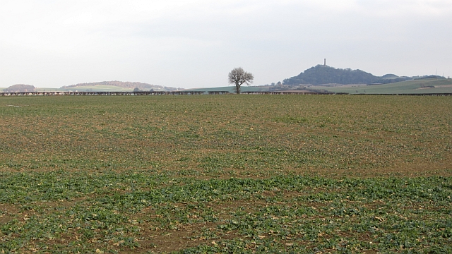
Newly cultivated field, Gladsmuir A field between the old and new A1 roads.
Newly cultivated field, Gladsmuir
A field between the old and new A1 roads.
Butterdean Woods A path runs around the perimeter of the wood.
Butterdean Woods
A path runs around the perimeter of the wood.
Roadside, Liberty Hall The scrub has been removed from this verge.
Roadside, Liberty Hall
The scrub has been removed from this verge.
Green Gates Wood Oak woods along a path between Liberty Hall and Letham Holdings.  East Lothian core path no. 110.
Green Gates Wood
Oak woods along a path between Liberty Hall and Letham Holdings. East Lothian core path no. 110.
East Lothian core path no.110 A wide field margin, prone to being muddy, but very dry today.
East Lothian core path no.110
A wide field margin, prone to being muddy, but very dry today.
Edge of Gladsmuir The former A1 on the western edge of Gladsmuir.
Edge of Gladsmuir
The former A1 on the western edge of Gladsmuir.
Between the A1s A narrow field between the A199 (once the A1) and the newer dual carriageway.
Between the A1s
A narrow field between the A199 (once the A1) and the newer dual carriageway.
Old A1 Now replaced by a dual carriageway.
Old A1
Now replaced by a dual carriageway.
Ruins, Macmerry World War II buildings, probably associated with the local airfield. They are between the old and new alignments of the A1.
Ruins, Macmerry
World War II buildings, probably associated with the local airfield. They are between the old and new alignments of the A1.
A long narrow field A rump field left after the A1 was rebuilt through arable land near Haddington.
A long narrow field
A rump field left after the A1 was rebuilt through arable land near Haddington.
A1 The new dual carriageway A1 looking eastwards. The strip of land between the new and old road is narrow here and is not in production.
A1
The new dual carriageway A1 looking eastwards. The strip of land between the new and old road is narrow here and is not in production.
A small wood near Merryhatton A clump of pines off a road to Huntington.
A small wood near Merryhatton
A clump of pines off a road to Huntington.
The Haddington Branch The North British Railway upset a lot of people when they chose to ignore Haddington and run some distance to the north of the town. Going north meant easier gradients and missing the high ground around Pencraig.  Haddington had to put up with a branch line.

There is no doubt that Haddington could support a service to Edinburgh now, but lack of capacity between Longniddry and Edinburgh is probably a problem. The trackbed is now a cycle path.
The Haddington Branch
The North British Railway upset a lot of people when they chose to ignore Haddington and run some distance to the north of the town. Going north meant easier gradients and missing the high ground around Pencraig. Haddington had to put up with a branch line. There is no doubt that Haddington could support a service to Edinburgh now, but lack of capacity between Longniddry and Edinburgh is probably a problem. The trackbed is now a cycle path.
Oilseed rape, Coates The crop is sitting out the frost awaiting temperatures which will allow growth.
Oilseed rape, Coates
The crop is sitting out the frost awaiting temperatures which will allow growth.
Winter wheat at Setonhill Still quite green below, and still a long way from ripe. The woods are Redcoll[left] and Setohill [right]. The Firth of Forth was visible through the gap.
Winter wheat at Setonhill
Still quite green below, and still a long way from ripe. The woods are Redcoll[left] and Setohill [right]. The Firth of Forth was visible through the gap.
Rape stubble at Setonhill Looking westwards towards the Pentland Hills, about 35km away.
Rape stubble at Setonhill
Looking westwards towards the Pentland Hills, about 35km away.
Country road at Cotty Burn Looking down from the Haddington/Longniddry Railway Walk, which is also NCN76.
Country road at Cotty Burn
Looking down from the Haddington/Longniddry Railway Walk, which is also NCN76.
NCN76 and footpath sign On the Haddington-Longniddry Railway Walk at Cotty Burn.
NCN76 and footpath sign
On the Haddington-Longniddry Railway Walk at Cotty Burn.
Show me another place!

Elvingston is located at Grid Ref: NT4674 (Lat: 55.959887, Lng: -2.860484)

Unitary Authority: East Lothian

Police Authority: The Lothians and Scottish Borders

What 3 Words

///fewer.marine.stubborn. Near Longniddry, East Lothian

Nearby Locations

Elvingston

Related Wikis

Gladsmuir

Gladsmuir is a village and parish in East Lothian, Scotland, situated on the A199 and near Tranent and Prestonpans. == Description == Gladsmuir's principal...

Haddington line

The Haddington line was a branch railway line connecting the Burgh of Haddington to the main line railway network at Longniddry. It was the first branch...

RAF Macmerry

Royal Air Force Macmerry or more simply RAF Macmerry is a former Royal Air Force satellite station located 4.5 miles (7.2 km) west of Haddington, East...

Longniddry railway station

Longniddry railway station is located at the southeast corner of the coastal village of Longniddry, East Lothian, Scotland. The station is on the East...

Nearby Amenities

Located within 500m of 55.959887,-2.860484
Power: pole
Lat/Long: 55.9611511/-2.8531676
Power: pole
Lat/Long: 55.9636372/-2.8646052
Power: pole
Lat/Long: 55.9617937/-2.8667825
Power: pole
Lat/Long: 55.9618883/-2.8610372
Power: pole
Lat/Long: 55.9640336/-2.8633017
Power: pole
Lat/Long: 55.9617366/-2.8594011
Power: pole
Lat/Long: 55.962175/-2.8641754
Power: pole
Lat/Long: 55.961582/-2.8577649
Power: pole
Lat/Long: 55.9613027/-2.8547984
Power: pole
Lat/Long: 55.9614514/-2.8564453
Power: pole
Lat/Long: 55.9620354/-2.8626734
Power: pole
Lat/Long: 55.9619934/-2.8654709
Elvingston
Place: locality
Lat/Long: 55.9588398/-2.8639733
Power: pole
Lat/Long: 55.9589015/-2.8585348
Power: pole
Lat/Long: 55.9587918/-2.8598204
Power: pole
Lat/Long: 55.9590869/-2.8611706
Power: pole
Lat/Long: 55.9592491/-2.861902
Power: pole
Lat/Long: 55.9594147/-2.8626667
Power: pole
Lat/Long: 55.9576709/-2.8591453
Power: pole
Lat/Long: 55.9571028/-2.8588161
Power: pole
Lat/Long: 55.9565359/-2.8584806
The data included in this document is from www.openstreetmap.org. The data is made available under ODbL.

Have you been to Elvingston?

Leave your review of Elvingston below (or comments, questions and feedback).