Bain Wood

Wood, Forest in Lincolnshire East Lindsey

England

Bain Wood

West Wykeham DMV: aerial 2021 One of Lincolnshire's finest. See: <span class="nowrap"><a title="https://www.heritagegateway.org.uk/Gateway/Results_Single.aspx?uid=MLI43549&resourceID=1006" rel="nofollow ugc noopener" href="https://www.heritagegateway.org.uk/Gateway/Results_Single.aspx?uid=MLI43549&resourceID=1006">Link</a><img style="margin-left:2px;" alt="External link" title="External link - shift click to open in new window" src="https://s1.geograph.org.uk/img/external.png" width="10" height="10"/></span>

West Wykeham first appears in the historical record in Domesday book, where a manor is recorded in the hands of Rainer de Brimou. This manor had sokeland in Ludford. At the time of Domesday there was minimum population of 11 people. Ralf de Criol succeeded the Domesday tenant Rainer de Brimou and is recorded as holding the manor in the Lindsey Survey of 1115. 

These lands in West Wykeham were held by Ralf de Criol in 1115, passed to his heir, Hugh de Scoteni in about 1155, and then to Hugh's son, Lambert de Scoteni before 1202. In 1212 the lands were in the hands of Thomas (probably the grandson of Lambert's younger brother, Walter). It was Thomas de Scoteni who granted lands in West Wykeham to Sixhills Priory in 1228-32.
West Wykeham DMV: aerial 2021 Credit: Chris

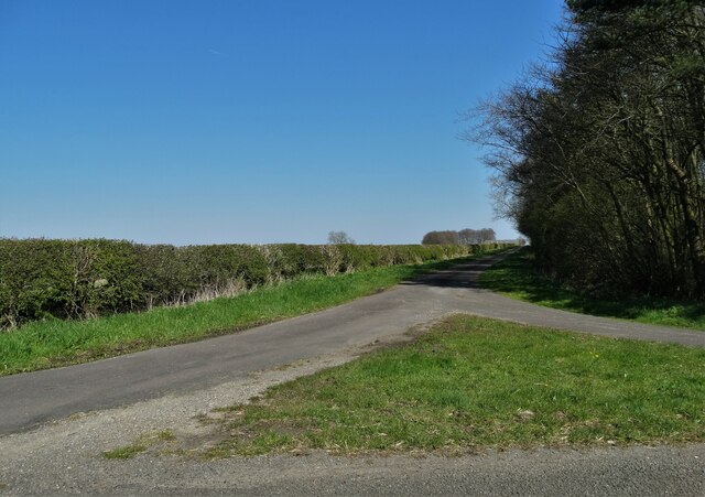
Bain Wood, located in Lincolnshire, is a picturesque forest that spans over an area of approximately 200 acres. Situated near the small village of Wood, this woodland is a popular destination for nature enthusiasts and hikers alike.

Bain Wood is characterized by its diverse range of tree species, including oak, birch, beech, and coniferous trees. The dense canopy formed by these towering trees creates a serene and tranquil atmosphere, making it an ideal place for a leisurely stroll or a peaceful picnic.

The forest is home to a variety of wildlife, providing a habitat for numerous species. Visitors may catch a glimpse of resident birds such as woodpeckers, owls, and various songbirds. Additionally, squirrels, rabbits, and deer can often be spotted as they go about their daily activities.

The wood is crisscrossed by a network of well-maintained trails, allowing visitors to explore the forest at their own pace. These paths cater to both casual walkers and more adventurous hikers, providing options for all fitness levels. Information boards placed strategically along the trails provide interesting facts about the flora and fauna found within the wood, enhancing the educational experience.

Bain Wood also offers amenities to enhance visitors' experience. There are designated picnic areas equipped with benches and tables, providing a comfortable spot to enjoy a meal amidst the natural surroundings. Furthermore, the wood is easily accessible, with ample parking and toilet facilities available nearby.

Overall, Bain Wood in Lincolnshire is a scenic and accessible forest, offering visitors the opportunity to immerse themselves in nature and enjoy the peaceful ambiance it provides.

If you have any feedback on the listing, please let us know in the comments section below.

Bain Wood Images

Images are sourced within 2km of 53.365995/-0.15698363 or Grid Reference TF2287. Thanks to Geograph Open Source API. All images are credited.

West Wykeham DMV: aerial 2021 One of Lincolnshire's finest. See: <span class="nowrap"><a title="https://www.heritagegateway.org.uk/Gateway/Results_Single.aspx?uid=MLI43549&resourceID=1006" rel="nofollow ugc noopener" href="https://www.heritagegateway.org.uk/Gateway/Results_Single.aspx?uid=MLI43549&resourceID=1006">Link</a><img style="margin-left:2px;" alt="External link" title="External link - shift click to open in new window" src="https://s1.geograph.org.uk/img/external.png" width="10" height="10"/></span>

West Wykeham first appears in the historical record in Domesday book, where a manor is recorded in the hands of Rainer de Brimou. This manor had sokeland in Ludford. At the time of Domesday there was minimum population of 11 people. Ralf de Criol succeeded the Domesday tenant Rainer de Brimou and is recorded as holding the manor in the Lindsey Survey of 1115. 

These lands in West Wykeham were held by Ralf de Criol in 1115, passed to his heir, Hugh de Scoteni in about 1155, and then to Hugh's son, Lambert de Scoteni before 1202. In 1212 the lands were in the hands of Thomas (probably the grandson of Lambert's younger brother, Walter). It was Thomas de Scoteni who granted lands in West Wykeham to Sixhills Priory in 1228-32.
West Wykeham DMV: aerial 2021
One of Lincolnshire's finest. See: LinkExternal link West Wykeham first appears in the historical record in Domesday book, where a manor is recorded in the hands of Rainer de Brimou. This manor had sokeland in Ludford. At the time of Domesday there was minimum population of 11 people. Ralf de Criol succeeded the Domesday tenant Rainer de Brimou and is recorded as holding the manor in the Lindsey Survey of 1115. These lands in West Wykeham were held by Ralf de Criol in 1115, passed to his heir, Hugh de Scoteni in about 1155, and then to Hugh's son, Lambert de Scoteni before 1202. In 1212 the lands were in the hands of Thomas (probably the grandson of Lambert's younger brother, Walter). It was Thomas de Scoteni who granted lands in West Wykeham to Sixhills Priory in 1228-32.
Girsby Vale and West Wykeham: aerial 2021 For West Wykeham see <a href="https://www.geograph.org.uk/photo/7002215">TF2188 : West Wykeham DMV: aerial 2021</a>.
Girsby Vale and West Wykeham: aerial 2021
Burgh on Bain - St Helen's Church
Field path leading northeast towards Gayton le Wold
Gayton le Wold - St Peter's Church
Gently undulating fields SE of Biscathorpe Plantation, Lincs
Grim's Mound, Grimblethorpe, Lincs The monument includes the earthwork remains of a bowl barrow known as Grim's
Mound located 110m above sea level in a commanding position on the summit of a
spur between the River Bain and one of its tributaries. It is a grassy mound
some 19m in diameter and 2.6m high, situated adjacent to a trackway running
between the sites of the medieval villages of Biscathorpe and Calcethorpe.
This trackway, which is today known as the Viking Way, overlies the eastern
perimeter of the monument and it bends slightly at this point.
Chance finds of worked flint have been recovered from the plough soil around
the monument which itself is largely undisturbed. Although the encircling
ditch, from which material for the mound was quarried, is not visible, it is
thought to survive buried beneath the present ground surface. (source ancientmonuments.co.uk)
Grim's Mound, Grimblethorpe, Lincs
The monument includes the earthwork remains of a bowl barrow known as Grim's Mound located 110m above sea level in a commanding position on the summit of a spur between the River Bain and one of its tributaries. It is a grassy mound some 19m in diameter and 2.6m high, situated adjacent to a trackway running between the sites of the medieval villages of Biscathorpe and Calcethorpe. This trackway, which is today known as the Viking Way, overlies the eastern perimeter of the monument and it bends slightly at this point. Chance finds of worked flint have been recovered from the plough soil around the monument which itself is largely undisturbed. Although the encircling ditch, from which material for the mound was quarried, is not visible, it is thought to survive buried beneath the present ground surface. (source ancientmonuments.co.uk)
West Wykeham DMV: aerial 2023 West Wykeham first appears in the historical record in Domesday book, where a manor is recorded in the hands of Rainer de Brimou. This manor had sokeland in Ludford. At the time of Domesday there was a minimum population of 11 people. Ralf de Criol succeeded the Domesday tenant Rainer de Brimou and is recorded as holding the manor in the Lindsey Survey of 1115.

These lands in West Wykeham were held by Ralf de Criol in 1115, passed to his heir, Hugh de Scoteni in about 1155, and then to Hugh's son, Lambert de Scoteni before 1202. In 1212 the lands were in the hands of Thomas (probably the grandson of Lambert's younger brother, Walter). It was Thomas de Scoteni who granted lands in West Wykeham to Sixhills Priory in 1228-32.

See: <span class="nowrap"><a title="https://www.heritagegateway.org.uk/Gateway/Results_Single.aspx?uid=MLI43549&resourceID=1006" rel="nofollow ugc noopener" href="https://www.heritagegateway.org.uk/Gateway/Results_Single.aspx?uid=MLI43549&resourceID=1006">Link</a><img style="margin-left:2px;" alt="External link" title="External link - shift click to open in new window" src="https://s1.geograph.org.uk/img/external.png" width="10" height="10"/></span>
West Wykeham DMV: aerial 2023
West Wykeham first appears in the historical record in Domesday book, where a manor is recorded in the hands of Rainer de Brimou. This manor had sokeland in Ludford. At the time of Domesday there was a minimum population of 11 people. Ralf de Criol succeeded the Domesday tenant Rainer de Brimou and is recorded as holding the manor in the Lindsey Survey of 1115. These lands in West Wykeham were held by Ralf de Criol in 1115, passed to his heir, Hugh de Scoteni in about 1155, and then to Hugh's son, Lambert de Scoteni before 1202. In 1212 the lands were in the hands of Thomas (probably the grandson of Lambert's younger brother, Walter). It was Thomas de Scoteni who granted lands in West Wykeham to Sixhills Priory in 1228-32. See: LinkExternal link
East Wykeham DMV and Park: aerial 2023 East Wykeham occurs in the Domesday Book, where a holding of only half a bovate was part of a manor at South Cadeby, and a further 5 bovates and 10 acres of meadow were sokeland of South Cadeby. There was another half a bovate that is recorded as waste. There was a minimum population of five people at that time. There is no manor in East Wykeham recorded in Domesday. In the Lindsey survey of 1115 the holdings of 5 and a half bovates in East Wykeham are in the hands of Alan of Lincoln and a further two bovates held by the Bishop of Lincoln.

The church at East Wykeham was granted to Sixhills Priory in the mid twelfth century; half from Supir de Bayeux and half from Ralf of Grimblethorpe. Included within these gifts were tofts and land in East Wykeham

See: <span class="nowrap"><a title="https://www.heritagegateway.org.uk/Gateway/Results_Single.aspx?uid=MLI40581&resourceID=1006" rel="nofollow ugc noopener" href="https://www.heritagegateway.org.uk/Gateway/Results_Single.aspx?uid=MLI40581&resourceID=1006">Link</a><img style="margin-left:2px;" alt="External link" title="External link - shift click to open in new window" src="https://s1.geograph.org.uk/img/external.png" width="10" height="10"/></span>

A historic park recorded on the 1907 Ordnance Survey map at Wykeham Hall: <span class="nowrap"><a title="https://www.heritagegateway.org.uk/Gateway/Results_Single.aspx?uid=MLI92238&resourceID=1006" rel="nofollow ugc noopener" href="https://www.heritagegateway.org.uk/Gateway/Results_Single.aspx?uid=MLI92238&resourceID=1006">Link</a><img style="margin-left:2px;" alt="External link" title="External link - shift click to open in new window" src="https://s1.geograph.org.uk/img/external.png" width="10" height="10"/></span>
East Wykeham DMV and Park: aerial 2023
East Wykeham occurs in the Domesday Book, where a holding of only half a bovate was part of a manor at South Cadeby, and a further 5 bovates and 10 acres of meadow were sokeland of South Cadeby. There was another half a bovate that is recorded as waste. There was a minimum population of five people at that time. There is no manor in East Wykeham recorded in Domesday. In the Lindsey survey of 1115 the holdings of 5 and a half bovates in East Wykeham are in the hands of Alan of Lincoln and a further two bovates held by the Bishop of Lincoln. The church at East Wykeham was granted to Sixhills Priory in the mid twelfth century; half from Supir de Bayeux and half from Ralf of Grimblethorpe. Included within these gifts were tofts and land in East Wykeham See: LinkExternal link A historic park recorded on the 1907 Ordnance Survey map at Wykeham Hall: LinkExternal link
Saint Helen's Church, Burgh on Bain The charming little church occupies an ancient  site where its  structure  evolved over a thousand years.
Saint Helen's Church, Burgh on Bain
The charming little church occupies an ancient site where its structure evolved over a thousand years.
On The Viking Way south of Little Gayton
Former chalk pit west of Gayton-le-Wold
Cattle at Gayton Manor
Gayton le Wold - St Peter's Church
Cracked pane of glass above the altar Gayton le Wold - St Peter's Church
Cracked pane of glass above the altar
Gayton le Wold - St Peter's Church
Farm track south of Gayton le Wold
The gates of Girsby Manor
Junction of Girsby Lane with Wykeham Lane
Show me another place!

Bain Wood is located at Grid Ref: TF2287 (Lat: 53.365995, Lng: -0.15698363)

Administrative County: Lincolnshire

District: East Lindsey

Police Authority: Lincolnshire

What 3 Words

///tentacles.marsh.cheeses. Near Wold Newton, Lincolnshire

Related Wikis

Burgh on Bain

Burgh on Bain is a village and civil parish in the East Lindsey district of Lincolnshire, England. It is situated on the A157 road, 7 miles (11 km) west...

Girsby, Lincolnshire

Girsby is a hamlet in the East Lindsey district of Lincolnshire, England. It is situated less than 1 mile (2 km) north from the A157 road, 7 miles (11...

East Wykeham

East Wykeham is a deserted medieval village or DMV, seen as earthworks, in the East Lindsey district of Lincolnshire, England. The earthworks are situated...

Grimblethorpe

Grimblethorpe is a hamlet in the East Lindsey district of Lincolnshire, England. It is situated 6 miles (10 km) west from Louth and just north of the village...

Gayton le Wold

Gayton le Wold is a village and civil parish in the East Lindsey district of Lincolnshire, England. It lies 6 miles (10 km) west from Louth, 3 miles (5...

West Wykeham

West Wykeham is a deserted medieval village in East Lindsey, Lincolnshire, England. It is situated just over 1 mile (1.6 km) east from Ludford. West Wykeham...

Biscathorpe

Biscathorpe is an ecclesiastical parish, deserted medieval village and former civil parish, now in the parish of Gayton le Wold, in the East Lindsey district...

Calcethorpe

Calcethorpe is a hamlet and deserted medieval village (DMV), in the East Lindsey district of Lincolnshire, England. It is situated approximately 5 miles...

Nearby Amenities

Located within 500m of 53.365995,-0.15698363
Note: Slippery road hazard for 3/4 mile sign (eastbound direction)
Traffic Sign Backward: GB:557,570[3/4 mile]
Lat/Long: 53.3624854/-0.1543192
Burgh on Bain Bridge
Place: locality
Source: Bing
Lat/Long: 53.362122/-0.1569811
The data included in this document is from www.openstreetmap.org. The data is made available under ODbL.

Have you been to Bain Wood?

Leave your review of Bain Wood below (or comments, questions and feedback).