Brook Copse

Wood, Forest in Surrey Mole Valley

England

Brook Copse

The Surrey Oaks pub at Parkgate
The Surrey Oaks pub at Parkgate Credit: James Insell

Brook Copse is a charming woodland area located in Surrey, England. Stretching across approximately 30 hectares, this tranquil forest offers visitors a peaceful retreat from the bustling city life. It is situated near the village of Shamley Green, just a short drive from Guildford.

The copse features a diverse range of tree species, including oak, beech, and birch, creating a rich and vibrant ecosystem. The woodland floor is covered with a lush carpet of ferns, bluebells, and other wildflowers, adding to its natural beauty. The abundance of flora in Brook Copse attracts a variety of wildlife, making it a popular spot for nature enthusiasts and birdwatchers.

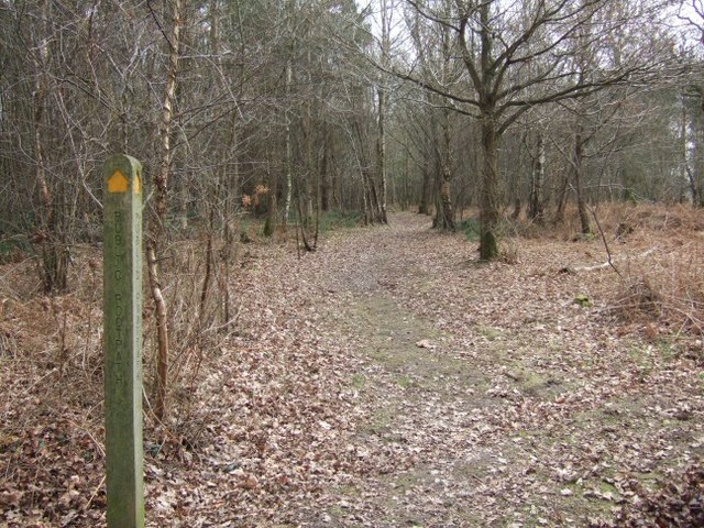
Visitors can explore the copse through a network of well-maintained footpaths, which wind their way through the trees. These paths offer stunning views of the surrounding countryside, providing ample opportunities for peaceful walks and picnics. There is also a small stream that runs through the woodland, adding to its picturesque charm.

Brook Copse is managed by a local conservation organization, ensuring the preservation of its natural habitat. The woodland is open to the public throughout the year, with no admission fees. It is an ideal destination for families, with plenty of space for children to play and discover nature.

Overall, Brook Copse is a hidden gem in Surrey, offering visitors a chance to connect with nature and enjoy the serenity of the countryside. Whether it’s a leisurely stroll or a day spent exploring the woodland, this enchanting forest provides a welcome escape from the demands of everyday life.

If you have any feedback on the listing, please let us know in the comments section below.

Brook Copse Images

Images are sourced within 2km of 51.182961/-0.29317239 or Grid Reference TQ1944. Thanks to Geograph Open Source API. All images are credited.

The Surrey Oaks pub at Parkgate
Telephone box at Parkgate
The Ali Raj Indian restaurant at Parkgate
Bridge at Ewood Lane
Entrance to the Woodland Trust's Hammond's Copse
Information point at the Woodland Trust's Hammond's Copse
Pond bay at Ewood, near Newdigate, Surrey Ewood was one of the main centres for ironmaking in the 15th century. The works were water-powered, driven by a pond which is thought to have been 200 acres in size. The pond bay (or dam) can still be seen behind a cottage on Ewood Lane.
Pond bay at Ewood, near Newdigate, Surrey
Ewood was one of the main centres for ironmaking in the 15th century. The works were water-powered, driven by a pond which is thought to have been 200 acres in size. The pond bay (or dam) can still be seen behind a cottage on Ewood Lane.
Track Junction in Hammond's Copse Looking down the South Eastern track
Track Junction in Hammond's Copse
Looking down the South Eastern track
Hammond's Copse
Hammond's Copse
The Surrey Oaks at Parkgate Seen from the lay-by next to <a href="https://www.geograph.org.uk/photo/25681">TQ2043 : Telephone box at Parkgate</a>.
The Surrey Oaks at Parkgate
Seen from the lay-by next to TQ2043 : Telephone box at Parkgate.
Newdigate Brickworks Nature Reserve Newdigate Brickworks opened in c.1928 and was a successful business for many years. The works closed during the Second World War and much of the site became derelict, but handmade bricks were made here on a smaller scale after the war, the trade lasting until 1974. The site then lay derelict until 2004, when a housing development was built on the old factory site and the four lakes left over from quarrying became a public nature reserve managed by the Surrey Wildlife Trust. The reserve covers 43 acres of lake, grassland and woodland near the centre of this grid-square.
Newdigate Brickworks Nature Reserve
Newdigate Brickworks opened in c.1928 and was a successful business for many years. The works closed during the Second World War and much of the site became derelict, but handmade bricks were made here on a smaller scale after the war, the trade lasting until 1974. The site then lay derelict until 2004, when a housing development was built on the old factory site and the four lakes left over from quarrying became a public nature reserve managed by the Surrey Wildlife Trust. The reserve covers 43 acres of lake, grassland and woodland near the centre of this grid-square.
Jubilee Hall Village hall built circa 1885 (according to the name plate) for Queen Victoria's golden jubilee and recently converted into a dwelling. The rusting corrugated iron roof has been replaced with tile but the essential character of the building has been retained.
Jubilee Hall
Village hall built circa 1885 (according to the name plate) for Queen Victoria's golden jubilee and recently converted into a dwelling. The rusting corrugated iron roof has been replaced with tile but the essential character of the building has been retained.
Main path out of Hammond's Copse This Woodland Trust property has several ways in via public footpaths and bridleways, but there is no public right of way here, although Woodland Trust woods are freely open to the public anyway. Beyond the gate just visible is a parking area for several cars.
Main path out of Hammond's Copse
This Woodland Trust property has several ways in via public footpaths and bridleways, but there is no public right of way here, although Woodland Trust woods are freely open to the public anyway. Beyond the gate just visible is a parking area for several cars.
Footpath to Broad Lane Looking from the edge of Hammond's Copse, which the footpath passes through on its way from Blanks Lane.
Footpath to Broad Lane
Looking from the edge of Hammond's Copse, which the footpath passes through on its way from Blanks Lane.
Bracken and Foxgloves, Hammond's Copse Most of this Woodland Trust wood on Weald Clay is somewhat acidic, judging by the vegetation, as here. Elsewhere in the wood there are more basic areas with Common Spotted-orchids along the paths.
Bracken and Foxgloves, Hammond's Copse
Most of this Woodland Trust wood on Weald Clay is somewhat acidic, judging by the vegetation, as here. Elsewhere in the wood there are more basic areas with Common Spotted-orchids along the paths.
Seat with limited prospect, Hammond's Copse If the vegetation were cut back, it could be seen that the prospect was intended to be over a pond (possibly in winter), or at least a very damp marshy area (certainly in summer).
Seat with limited prospect, Hammond's Copse
If the vegetation were cut back, it could be seen that the prospect was intended to be over a pond (possibly in winter), or at least a very damp marshy area (certainly in summer).
Houses in Mulberry Place, Newdigate Built on the site of Newdigate Brickworks.
Houses in Mulberry Place, Newdigate
Built on the site of Newdigate Brickworks.
Agricultural heap of what? Looking like cat litter or unweathered blue clay, this large heap is probably neither.
Agricultural heap of what?
Looking like cat litter or unweathered blue clay, this large heap is probably neither.
Show me another place!

Brook Copse is located at Grid Ref: TQ1944 (Lat: 51.182961, Lng: -0.29317239)

Administrative County: Surrey

District: Mole Valley

Police Authority: Surrey

What 3 Words

///skill.fried.mutual. Near Holmwood, Surrey

Nearby Locations

Brook Copse

Related Wikis

Newdigate

Newdigate is a village and civil parish in the Mole Valley borough of Surrey lying in a relatively flat part of the Weald to the east of the A24 road between...

Newdigate Brickworks

Newdigate Brickworks is a 24-hectare (59-acre) nature reserve in Newdigate in Surrey. It is managed by the Surrey Wildlife Trust.The clay pits of this...

Holmwood railway station

Holmwood railway station serves the villages of Beare Green and South Holmwood in Surrey, England, on the Sutton and Mole Valley Lines between Dorking...

Wotton Hundred

The Hundred of Wotton, Wotton Hundred or Dorking Hundred was a hundred in Surrey, England. The hundred comprised a south-central portion of the county...

South Holmwood

South Holmwood () is a semi-rural village in Surrey, England. It can be considered cognate with its wider civil parish, which stretches to the east to...

Inholms Clay Pit

Inholms Clay Pit is a 8.4-hectare (21-acre) Local Nature Reserve south of Dorking in Surrey. It is owned by Mole Valley District Council and from 2009...

A24 road (England)

The A24 is a major road in England that runs for 53.2 miles (85.6 km) from Clapham in south-west London to Worthing on the English Channel in West Sussex...

Capel, Surrey

Capel () is a village and civil parish in southern Surrey, England. It is equidistant between Dorking and Horsham – about 5 miles (8.0 km) away. Around...

Nearby Amenities

Located within 500m of 51.182961,-0.29317239
Barrier: stile
Lat/Long: 51.1828362/-0.2947098
Barrier: stile
Lat/Long: 51.1840293/-0.2951699
Power: pole
Source: Bing
Lat/Long: 51.1833245/-0.2980578
Power: pole
Source: Bing
Lat/Long: 51.1855773/-0.298503
Power: pole
Source: Bing
Lat/Long: 51.1854765/-0.2968884
Power: pole
Source: Bing
Lat/Long: 51.1849687/-0.2983797
Ford: yes
Lat/Long: 51.1827824/-0.2939411
Henfold Lakes Fishing
Leisure: fishing
Lat/Long: 51.1822088/-0.2986393
The data included in this document is from www.openstreetmap.org. The data is made available under ODbL.

Have you been to Brook Copse?

Leave your review of Brook Copse below (or comments, questions and feedback).