Fullingmill Copse

Wood, Forest in Sussex Horsham

England

Fullingmill Copse

Footpath to Kensett's Corner Taken from North Lane bridleway.
Footpath to Kensett's Corner Credit: Simon Carey

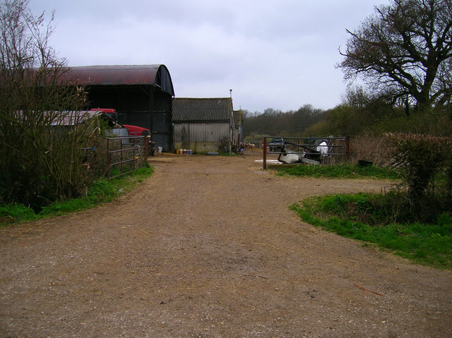
Fullingmill Copse is a picturesque woodland located in Sussex, England. Covering an area of approximately 20 acres, it is a stunning example of a mature mixed woodland. The copse is characterized by its dense canopy of towering oak, beech, and ash trees, which provide a rich habitat for a diverse range of flora and fauna.

The woodland floor is adorned with a carpet of bluebells in the spring, creating a breathtakingly beautiful sight. Other native wildflowers such as wood anemones, primroses, and wild garlic also thrive in the copse, adding vibrant splashes of color throughout the year.

The copse is home to a variety of bird species including woodpeckers, tawny owls, and nuthatches. Visitors may also catch glimpses of squirrels darting through the trees or deer grazing in the undergrowth. The tranquil atmosphere and abundance of wildlife make Fullingmill Copse a popular destination for nature enthusiasts and birdwatchers.

In addition to its natural beauty, Fullingmill Copse has historical significance. It was once part of a larger estate, and remnants of ancient boundaries and ditches can still be seen within the woodland. The copse has also played a role in local folklore, with tales of hidden treasure and mythical creatures associated with the area.

Fullingmill Copse is easily accessible, with well-maintained paths that allow visitors to explore its enchanting surroundings. Whether it is for a leisurely walk, a picnic, or simply to immerse oneself in the tranquility of nature, Fullingmill Copse offers a truly captivating experience for all who visit.

If you have any feedback on the listing, please let us know in the comments section below.

Fullingmill Copse Images

Images are sourced within 2km of 50.932294/-0.35993022 or Grid Reference TQ1516. Thanks to Geograph Open Source API. All images are credited.

Footpath to Kensett's Corner Taken from North Lane bridleway.
Footpath to Kensett's Corner
Taken from North Lane bridleway.
Coppicing, Brickyard Copse Taken from North Lane bridleway.
Coppicing, Brickyard Copse
Taken from North Lane bridleway.
Basing Wood A lone oak stands guard over an army of firs. Taken from North Lane bridleway just north of Coombelands.
Basing Wood
A lone oak stands guard over an army of firs. Taken from North Lane bridleway just north of Coombelands.
Capite Wood Taken from the footpath that links Woodman's Farm with Buckells Farm. The dense cover of the firs gives it a spooky feel.
Capite Wood
Taken from the footpath that links Woodman's Farm with Buckells Farm. The dense cover of the firs gives it a spooky feel.
Footbridge, Capite Wood Carrying the footpath that links Woodman's Farm to Buckells Farm
Footbridge, Capite Wood
Carrying the footpath that links Woodman's Farm to Buckells Farm
Field near Dalesdown School Chanctonbury Ring can be seen between the two trees to the right just above the less than bucolic flytipping area. Taken from the point where the footpath crosses the farm road.
Field near Dalesdown School
Chanctonbury Ring can be seen between the two trees to the right just above the less than bucolic flytipping area. Taken from the point where the footpath crosses the farm road.
Smiley Face, Honeybridge Lane Painted sign next to the entrance of Dalesdown Educational Establishment.
Smiley Face, Honeybridge Lane
Painted sign next to the entrance of Dalesdown Educational Establishment.
Outbuildings, Honeybridge Farm Known as Starkers Farm on the 1940s map. Taken from the footpath that links Daylands Farm with Kings Barn Farm.
Outbuildings, Honeybridge Farm
Known as Starkers Farm on the 1940s map. Taken from the footpath that links Daylands Farm with Kings Barn Farm.
Field, Jessops Farm Taken from the footpath that goes through the farm.
Field, Jessops Farm
Taken from the footpath that goes through the farm.
Footpath, Jack O'Lantern Wood This is one of the better ones too!
Footpath, Jack O'Lantern Wood
This is one of the better ones too!
The route to Hawking Sopers Common Copse is to the right and those rainclouds were heading my way.
The route to Hawking Sopers
Common Copse is to the right and those rainclouds were heading my way.
Dying Deer, near Jessops Farm On the footpath that heads south from the farm. Both back legs seemed to be gone. Not much I could do I'm afraid.
Dying Deer, near Jessops Farm
On the footpath that heads south from the farm. Both back legs seemed to be gone. Not much I could do I'm afraid.
Small Hill near Furzfield Cottage Taken from Spithandle Lane path. The peak should have had Upper Barn on it but this did not appear to be either there or visible.
Small Hill near Furzfield Cottage
Taken from Spithandle Lane path. The peak should have had Upper Barn on it but this did not appear to be either there or visible.
Colour amid the gloom, Spithandle Copse Amongst the churned up mudbath that was Spithandle Lane was the odd bloom of spring flowers and shoots which make a lovely contrast to the murky browns elsewhere
Colour amid the gloom, Spithandle Copse
Amongst the churned up mudbath that was Spithandle Lane was the odd bloom of spring flowers and shoots which make a lovely contrast to the murky browns elsewhere
Spithandle Lane Spithandle Copse to the right, Spithandle Rough to the left. The road at the bottom left heads to College Wood Farm. The lane itself links Wiston to Horsebridge Common.
Spithandle Lane
Spithandle Copse to the right, Spithandle Rough to the left. The road at the bottom left heads to College Wood Farm. The lane itself links Wiston to Horsebridge Common.
Outbuildings, Guessgate Farm Taken from the footpath that links Spithandle Lane to the A283.
Outbuildings, Guessgate Farm
Taken from the footpath that links Spithandle Lane to the A283.
Wiston Viewed from the footpath that links the village with Upper Chancton Farm. The original village was based around the church at the foot of the Downs but through the ages the population steadily migrated northwards particularly along the wasteland near the old decayed hamlet of Buncton. The last of the villagers were moved out in the 19th century when Wiston House extended its park.
Wiston
Viewed from the footpath that links the village with Upper Chancton Farm. The original village was based around the church at the foot of the Downs but through the ages the population steadily migrated northwards particularly along the wasteland near the old decayed hamlet of Buncton. The last of the villagers were moved out in the 19th century when Wiston House extended its park.
Abbots House An 18th century farmhouse on Hole Street a minor lane linking the A283 with Ashington.
Abbots House
An 18th century farmhouse on Hole Street a minor lane linking the A283 with Ashington.
Show me another place!

Fullingmill Copse is located at Grid Ref: TQ1516 (Lat: 50.932294, Lng: -0.35993022)

Administrative County: West Sussex

District: Horsham

Police Authority: Sussex

What 3 Words

///after.drives.birthdays. Near Ashington, West Sussex

Related Wikis

Wiston, West Sussex

Wiston is a scattered village and civil parish in the Horsham District of West Sussex, England. It lies on the A283 road 2.8 miles (4.5 km) northwest of...

Ashington, West Sussex

Ashington is a village and civil parish in the Horsham District of West Sussex, England. It lies on the A24 road 3 miles (4.8 km) north-east of Storrington...

Buncton

Buncton () is a small village in the Horsham District of West Sussex, England, part of the civil parish of Wiston 0.5 miles (0.80 km) north. It lies to...

All Saints Church, Buncton

All Saints Church is an Anglican church in the hamlet of Buncton in the district of Horsham, one of seven local government districts in the English county...

St James's Church, Ashurst

St James's Church is a Church of England parish church in Ashurst, West Sussex. The church is a grade I listed building and it dates from the early 12th...

South Downs National Park

The South Downs National Park is England's newest national park, designated on 31 March 2010. The park, covering an area of 1,627 square kilometres (628...

Ashurst, West Sussex

Ashurst is a village and civil parish in the Horsham District of West Sussex, England, about 2 miles (3.2 km) west of Henfield, and 11 miles (18 km) south...

Fountain Inn, Ashurst

The Fountain Inn is a 16th-century public house in the village of Ashurst, in the Horsham district of West Sussex, England. After a period as a farmhouse...

Related Videos

Horley Walkie Talkies Go To Knepp park

Local Walking Ambling Group Called the Horley Walkie Talkies go to Knepp Park at Dial Post/Shipley for a lovley Amble.

St Peters Student Weekend Away 2023!

In this video I am in Dalesdown on a student Weekend Away with St Peters church. Lydia's channel: A girl of hope ...

Painting and Music with Hester Berry and David Smale (Friday 10th May, 2024)

Doors 6.30pm Event starts at 7.00pm For one evening only, the Knepp Rewilding Project will play host to an atmospheric evening ...

Nearby Amenities

Located within 500m of 50.932294,-0.35993022
The data included in this document is from www.openstreetmap.org. The data is made available under ODbL.

Have you been to Fullingmill Copse?

Leave your review of Fullingmill Copse below (or comments, questions and feedback).