Dobbin's Wood

Wood, Forest in Lincolnshire South Kesteven

England

Dobbin's Wood

Stanton's Pit
Stanton's Pit Credit: Bob Harvey

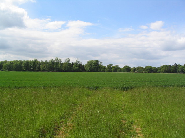
Dobbin's Wood is a picturesque woodland located in the county of Lincolnshire, England. Situated near the village of Dobbin, the wood stretches across approximately 100 acres of land, making it a significant natural attraction in the area. The forest is predominantly composed of deciduous trees, such as oak, beech, and ash, creating a rich and diverse ecosystem.

The wood offers a tranquil and serene environment, making it a popular destination for nature enthusiasts, hikers, and those seeking a peaceful retreat. A network of well-maintained footpaths allows visitors to explore the wood at their leisure, providing opportunities to observe the local wildlife and enjoy the beauty of the surroundings.

Within Dobbin's Wood, there are several clearings that provide picturesque spots for picnics or simply to sit and appreciate the natural scenery. These clearings are often adorned with wildflowers during the spring and summer months, adding a splash of vibrant colors to the already breathtaking landscape.

The wood is also home to various species of birds, including woodpeckers, owls, and songbirds, making it a haven for birdwatchers. Additionally, small mammals such as squirrels, foxes, and rabbits can be spotted throughout the woodland, adding to the charm and diversity of the area.

Dobbin's Wood is managed by the local conservation authority, ensuring the preservation and protection of its natural beauty for future generations to enjoy. The wood provides a peaceful escape from the hustle and bustle of everyday life, offering visitors the chance to connect with nature and experience the tranquility of this enchanting woodland.

If you have any feedback on the listing, please let us know in the comments section below.

Dobbin's Wood Images

Images are sourced within 2km of 52.751365/-0.4557709 or Grid Reference TF0418. Thanks to Geograph Open Source API. All images are credited.

Stanton's Pit
Stanton's Pit
Roadside trees A flash of late afternoon low angle sunlight.
Roadside trees
A flash of late afternoon low angle sunlight.
Country road near Little Bytham
Track  to Hale House Plantation, Grimsthorpe Estate This may not be a right of way, I seem to have lost the cycle track.
Track to Hale House Plantation, Grimsthorpe Estate
This may not be a right of way, I seem to have lost the cycle track.
Old sand pits behind Warren Cottage Just off (and invisible from) the road from Little Bytham to Witham on the Hill
Old sand pits behind Warren Cottage
Just off (and invisible from) the road from Little Bytham to Witham on the Hill
Looking across barley fields towards Scottlethorpe Grange
Woods of Grimsthorpe Estate from Hale House Road
Track past Kennel Plantation, Grimsthorpe Estate The wooden sign below the tree to the left of the track is one of a number of signs indicating a bicycle track.
Track past Kennel Plantation, Grimsthorpe Estate
The wooden sign below the tree to the left of the track is one of a number of signs indicating a bicycle track.
End of Halehouse Road at Hale House ruin, Grimsthorpe Estate Public access along the road/track leading south west from Scottlethorpe along the east side of Grimsthorpe Park ends here (the track turns left into a shooting range). However, other tracks do allow egress to Little Bytham.
End of Halehouse Road at Hale House ruin, Grimsthorpe Estate
Public access along the road/track leading south west from Scottlethorpe along the east side of Grimsthorpe Park ends here (the track turns left into a shooting range). However, other tracks do allow egress to Little Bytham.
Church of St Andrew, Witham on the Hill Earliest portions are mid 12th C. In 1736 the original tower and spire collapsed; the lives of the bell ringers being saved because they were taking a mid-session break at the local tavern.
Church of St Andrew, Witham on the Hill
Earliest portions are mid 12th C. In 1736 the original tower and spire collapsed; the lives of the bell ringers being saved because they were taking a mid-session break at the local tavern.
Cottages, Witham on the Hill At the entrance to this attractive village, on the road from Little Bytham
Cottages, Witham on the Hill
At the entrance to this attractive village, on the road from Little Bytham
Witham Hall, Witham on the Hill Dating from the 18th C. Now a preparatory school
Witham Hall, Witham on the Hill
Dating from the 18th C. Now a preparatory school
Track leading from Lings Farm View north toward its entrance on the Little Bytham to Witham on the Hill road.
Lings Farm is named Careby Farm on the older OS map.
Track leading from Lings Farm
View north toward its entrance on the Little Bytham to Witham on the Hill road. Lings Farm is named Careby Farm on the older OS map.
Sunday cricket, Witham on the Hill
Stanton's Pit Nature Reserve Flooded former quarry managed by Lincolnshire Wildlife Trust
Stanton's Pit Nature Reserve
Flooded former quarry managed by Lincolnshire Wildlife Trust
Bridleway northwards down Fountains Hill Many of the fields in this area had been harvested by mid July
Bridleway northwards down Fountains Hill
Many of the fields in this area had been harvested by mid July
Bridleway north from Witham on the Hill A good bridleway runs north from Witham on the Hill to the disused railway track at Elder Wood
Bridleway north from Witham on the Hill
A good bridleway runs north from Witham on the Hill to the disused railway track at Elder Wood
View to Elderwood Cottage From the bridleway running north from Witham on the Hill
View to Elderwood Cottage
From the bridleway running north from Witham on the Hill
Show me another place!

Dobbin's Wood is located at Grid Ref: TF0418 (Lat: 52.751365, Lng: -0.4557709)

Administrative County: Lincolnshire

District: South Kesteven

Police Authority: Lincolnshire

What 3 Words

///issuer.motels.simulations. Near Bourne, Lincolnshire

Related Wikis

Bourne Rural District

Bourne was a rural district in Lincolnshire, Parts of Kesteven from 1894 to 1931. It was created by the Local Government Act 1894 based on the Bourne rural...

Witham Hall

Witham Hall is an independent boarding and day school situated in Witham on the Hill, Lincolnshire, England. == The hall == The house is described by Sir...

Witham on the Hill

Witham on the Hill is a village and civil parish in the South Kesteven district of Lincolnshire, England. The population of the civil parish was 260 at...

Lound, Lincolnshire

Lound is a village in the South Kesteven district of Lincolnshire, England. It is situated about 2 miles (3 km) south-west from the town of Bourne. Originally...

Little Bytham railway station

Little Bytham railway station was a station in Little Bytham, Lincolnshire on the Great Northern Railway main line. It closed in 1959. The Midland and...

Careby

Careby is the principal village in the a civil parish of Careby Aunby and Holywell [in which the population is included] in the South Kesteven district...

Toft, Lincolnshire

Toft is a small village in the South Kesteven district of Lincolnshire, England. It is situated approximately 2 miles (3 km) south-west from Bourne on...

St Medardus and St Gildardus Church, Little Bytham

The church of St Medardus and St Gildardus in Little Bytham, Lincolnshire, England, is a Grade I listed building. It is dedicated to two 6th-century French...

Nearby Amenities

Located within 500m of 52.751365,-0.4557709
Power: pole
Lat/Long: 52.7486996/-0.4615948
Power: pole
Lat/Long: 52.748715/-0.4602566
Power: pole
Lat/Long: 52.7487283/-0.4586747
Power: pole
Lat/Long: 52.7487559/-0.4570759
Power: pole
Lat/Long: 52.7487692/-0.4554307
Power: pole
Lat/Long: 52.7488834/-0.4539195
Power: pole
Lat/Long: 52.7489763/-0.4527152
Power: pole
Lat/Long: 52.7490581/-0.451506
Power: pole
Lat/Long: 52.749137/-0.4504503
Power: pole
Lat/Long: 52.7496271/-0.4493432
The data included in this document is from www.openstreetmap.org. The data is made available under ODbL.

Have you been to Dobbin's Wood?

Leave your review of Dobbin's Wood below (or comments, questions and feedback).