Eckington

Settlement in Worcestershire Wychavon

England

Eckington

B4080 at the access for Nortonside Farm The signpost to the farm can be seen pointing left from the main road.
B4080 at the access for Nortonside Farm Credit: Peter Whatley

Eckington is a small village located in the county of Worcestershire, England. Situated on the eastern bank of the River Avon, it lies approximately 9 miles south of the city of Worcester and 5 miles northeast of the town of Pershore. The village is nestled in a picturesque rural setting, surrounded by rolling hills and farmland.

Eckington has a rich history dating back to the Anglo-Saxon period, with evidence of settlement in the area since the 6th century. The village is known for its charming traditional architecture, with many timber-framed houses and thatched cottages adorning its streets.

The heart of Eckington is its village green, a focal point for community events and activities. The green is also home to the St. Peter's Church, a Grade II listed building, which dates back to the 12th century and showcases beautiful medieval architecture.

Eckington offers a range of amenities for its residents and visitors. The village has a primary school, a community hall, and a local pub, providing a sense of community and gathering spaces. The surrounding countryside offers ample opportunities for outdoor activities, including walking, cycling, and fishing in the nearby River Avon.

Transport links in Eckington are well-connected, with regular bus services to Worcester and Pershore. The village is also conveniently located near major roads, with the A38 passing through nearby Pershore, providing easy access to larger towns and cities in the region.

In summary, Eckington is a charming village in Worcestershire, known for its historic buildings, scenic surroundings, and strong sense of community.

If you have any feedback on the listing, please let us know in the comments section below.

Eckington Images

Images are sourced within 2km of 52.071638/-2.115577 or Grid Reference SO9241. Thanks to Geograph Open Source API. All images are credited.

B4080 at the access for Nortonside Farm The signpost to the farm can be seen pointing left from the main road.
B4080 at the access for Nortonside Farm
The signpost to the farm can be seen pointing left from the main road.
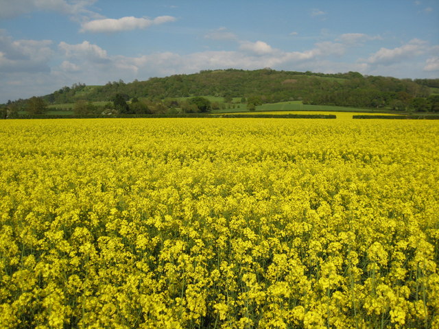
Oil seed rape and Bredon Hill View to Bredon Hill from the west over a field of oil seed rape in blossom, to the north of Bredon's Norton.
Oil seed rape and Bredon Hill
View to Bredon Hill from the west over a field of oil seed rape in blossom, to the north of Bredon's Norton.
Grazing near Nortonside Farm
Approaching White's Farm Crossing
White's Farm Level Crossing near Bredon's Norton
The old main road The old A4104 has now become a parking lot and storage space at this end. Still a right of way, but barely accessible over a large mound of earth.
The old main road
The old A4104 has now become a parking lot and storage space at this end. Still a right of way, but barely accessible over a large mound of earth.
Landing strip near Woodmancote This marker denotes the eastern end of the private grass landing strip to the north of the village. Large barns serving as hangars on the left. The Malvern Hills in the distance (the Worcestershire Beacon is just above the wind sock).
See <a href="https://www.geograph.org.uk/photo/2448255">SO9043 : Landing strip near Woodmancote</a> for the reverse view.
Landing strip near Woodmancote
This marker denotes the eastern end of the private grass landing strip to the north of the village. Large barns serving as hangars on the left. The Malvern Hills in the distance (the Worcestershire Beacon is just above the wind sock). See SO9043 : Landing strip near Woodmancote for the reverse view.
Farm track near Defford Heading east with Bredon Hill on the right. The landowner here kindly allows access along several permitted pathways, not just the public rights of ways like this one.
Farm track near Defford
Heading east with Bredon Hill on the right. The landowner here kindly allows access along several permitted pathways, not just the public rights of ways like this one.
Track north of Woodmancote Heading north to the landing strip hangars just behind the farmhouse.
Track north of Woodmancote
Heading north to the landing strip hangars just behind the farmhouse.
Sheep pasture at Strensham Looking north across lush sheep pasture to the River Avon. On the left is one of the large radar dishes of the Defford satellite communications site.
Sheep pasture at Strensham
Looking north across lush sheep pasture to the River Avon. On the left is one of the large radar dishes of the Defford satellite communications site.
Trig point at Strensham Looking north-west across sheep pasture to the northern Malvern Hills.
Trig point at Strensham
Looking north-west across sheep pasture to the northern Malvern Hills.
Site of Strensham Castle Looking west towards the well-preserved moat around the site of what was once a moated manor house. The original manor house was fortified in 1388 and was probably destroyed in the 17th century after the Civil War as it was a Royalist stronghold. Moat Farm is just in view on the left and houses at Lower Strensham are on the right.
Site of Strensham Castle
Looking west towards the well-preserved moat around the site of what was once a moated manor house. The original manor house was fortified in 1388 and was probably destroyed in the 17th century after the Civil War as it was a Royalist stronghold. Moat Farm is just in view on the left and houses at Lower Strensham are on the right.
Moat at Strensham Castle Looking east to Strensham Church on the hill.
Moat at Strensham Castle
Looking east to Strensham Church on the hill.
B4080 at the junction for The Combertons
Lane to The Combertons
House reconstruction on the lane to The Combertons
Bredon Hill from the lane to the Combertons Banbury Stone Tower is visible on the right skyline.
Bredon Hill from the lane to the Combertons
Banbury Stone Tower is visible on the right skyline.
Glowering sky over Nafford Road
Show me another place!

Eckington is located at Grid Ref: SO9241 (Lat: 52.071638, Lng: -2.115577)

Administrative County: Worcestershire

District: Wychavon

Police Authority: West Mercia

What 3 Words

///undercuts.resorting.mount. Near Eckington, Worcestershire

Nearby Locations

Eckington

Related Wikis

Eckington, Worcestershire

Eckington is a small village near to the southern border of the English county of Worcestershire, according to the 2001 census it had a population of 1...

Eckington railway station

Eckington railway station was a railway station to serve Eckington in Worcestershire. The station was opened by the Birmingham and Gloucester Railway...

Eckington Bridge

Eckington Bridge is a stone bridge over the River Avon in Eckington in the English county of Worcestershire. It is a Grade II* listed building and has...

Bow Brook

The Bow Brook is a substantial brook that flows for 28.8 miles (46.3 km) through Worcestershire, England. It is a lower tributary of the River Avon which...

Nearby Amenities

Located within 500m of 52.071638,-2.115577
Post Box
Fixme: Need to revisit and get aux data and check number.
Post Box Design: type_a
Post Box Type: pillar
Ref: WR10 393
Source: observation
Source Ref: conjecture
Lat/Long: 52.0716066/-2.1155763
Eckington Stores
Addr Postcode: WR10 3AN
Addr Street: Church Street
Fhrs Id: 686261
Shop: convenience
Lat/Long: 52.0697405/-2.1144124
Public Bookcase
Booth: K6
Colour: red
Man Made: telephone_box
Note: From view driving past, appears to be a book exchange / mini-library
Public Bookcase Type: phone_box
Lat/Long: 52.0721099/-2.1156145
Post Box
Collection Times: Mo-Fr 16:30; Sa 11:15
Post Box Type: lamp
Ref: WR10 414
Royal Cypher: EIIR
Royal Cypher Wikidata: Q33102113
Lat/Long: 52.0690124/-2.1165496
Barrier: lytch_gate
Lat/Long: 52.0727827/-2.1153407
Bus Stop
Bell Inn
Bus: yes
Naptan AtcoCode: 2000G031700
Naptan Bearing: N
Naptan CommonName: Bell Inn
Naptan Indicator: Adj
Naptan Landmark: Bell Inn
Naptan NaptanCode: wocdpwmj
Naptan Street: Church street
Public Transport: platform
Source: naptan_import
Lat/Long: 52.0699984/-2.1148102
Bus Stop
Eckington Memorial
Naptan AtcoCode: 2000G031701
Naptan Bearing: N
Naptan BusStopType: CUS
Naptan CommonName: Eckington- Memorial
Naptan Indicator: Adj
Naptan Landmark: War Memorial
Naptan NaptanCode: wocdpwmp
Naptan Street: Church Street
Naptan Verified: no
Public Transport: platform
Source: naptan_import
Lat/Long: 52.0718752/-2.1155764
Bus Stop
Eckington Memorial
Naptan AtcoCode: 2000G031799
Naptan Bearing: S
Naptan BusStopType: CUS
Naptan CommonName: Eckington Memorial
Naptan Indicator: Opp
Naptan Landmark: War Memorial
Naptan NaptanCode: wocdjdta
Naptan Street: Church Street
Naptan Verified: no
Public Transport: platform
Source: naptan_import
Lat/Long: 52.0720613/-2.1153627
Bus Stop
Eckington First School
Bus: yes
Naptan AtcoCode: 2000G671010
Naptan Bearing: NE
Naptan CommonName: Eckington First School
Naptan Indicator: Adj
Naptan Landmark: School
Naptan NaptanCode: wocdpjmj
Naptan Street: School Lane
Naptan Verified: no
Public Transport: platform
Source: naptan_import
Lat/Long: 52.0705816/-2.1113906
Bus Stop
Jarvis Drive
Bus: yes
Naptan AtcoCode: 2000G673006
Naptan Bearing: NW
Naptan CommonName: Jarvis Drive
Naptan Crossing: Jarvis Drive
Naptan Indicator: Opp
Naptan NaptanCode: wocdatwt
Naptan Street: Jarvis Street
Naptan Verified: no
Public Transport: platform
Source: naptan_import
Lat/Long: 52.0720622/-2.1134921
Bus Stop
Eckington Bell Inn
Bus: yes
Naptan AtcoCode: 2000G673011
Naptan Bearing: S
Naptan CommonName: Eckington Bell Inn
Naptan Indicator: Opp
Naptan Landmark: Eckington Bell Inn
Naptan NaptanCode: wocdawap
Naptan Street: Church St
Public Transport: platform
Source: naptan_import
Lat/Long: 52.0697683/-2.1144894
Eckington
Historic Railway: station
Railway: site
Source: NPE
Wikidata: Q5332915
Wikipedia: en:Eckington railway station
Lat/Long: 52.0691477/-2.1155148
Turning Circle
Lat/Long: 52.0696423/-2.1131112
LKOne
Shop: hairdresser
Lat/Long: 52.0695873/-2.1146119
Location Transition: yes
Power: pole
Lat/Long: 52.0677183/-2.1184424
Mill Lane
Location Transition: yes
Power: pole
Transformer: distribution
Voltage Primary: 11000
Lat/Long: 52.0681437/-2.1176628
Power: pole
Lat/Long: 52.0680291/-2.1197612
Power: pole
Lat/Long: 52.0689688/-2.1196051
Location Transition: yes
Power: pole
Lat/Long: 52.0692499/-2.1189371
Power: pole
Lat/Long: 52.0740924/-2.1216021
Power: pole
Lat/Long: 52.0749603/-2.1195248
Power: pole
Lat/Long: 52.0749766/-2.1203982
Power: pole
Lat/Long: 52.0752663/-2.1186848
Power: pole
Lat/Long: 52.0755075/-2.1189901
Power: pole
Lat/Long: 52.0759775/-2.116974
Eckington Memorial
Historic: memorial
Memorial: war_memorial
Source: naptan
Lat/Long: 52.071872/-2.1156194
Defibrillator
Description: On exterior wall of Eckington recreation grond pavilion, facing the car park off the B4080 Pershore Road.
Emergency: defibrillator
Ref: 1952
Lat/Long: 52.0741887/-2.1160784
Defibrillator
Addr Postcode: WR10 3AU
Defibrillator Location: On exterior wall of Eckington Memorial Hall, towards the rear facing the car park and School Lane.
Emergency: defibrillator
Indoor: no
Ref: 1951
Ref GB The Circuit: CECAA59F-8872-445B-A843-7460D13D166D
Lat/Long: 52.0707687/-2.1115315
Waste Basket
Lat/Long: 52.074207/-2.1157241
Generator Method: photovoltaic
Generator Output Electricity: yes
Generator Source: solar
Generator Type: solar_photovoltaic_panel
Location: roof
Power: generator
Lat/Long: 52.070579/-2.1199724
Generator Method: photovoltaic
Generator Output Electricity: yes
Generator Source: solar
Generator Type: solar_photovoltaic_panel
Location: roof
Power: generator
Lat/Long: 52.0687638/-2.1126553
Generator Method: photovoltaic
Generator Output Electricity: yes
Generator Source: solar
Generator Type: solar_photovoltaic_panel
Location: roof
Power: generator
Lat/Long: 52.0720794/-2.1095815
Generator Method: photovoltaic
Generator Output Electricity: yes
Generator Source: solar
Generator Type: solar_photovoltaic_panel
Location: roof
Power: generator
Lat/Long: 52.0717628/-2.111958
Generator Method: photovoltaic
Generator Output Electricity: yes
Generator Source: solar
Generator Type: solar_photovoltaic_panel
Location: roof
Power: generator
Lat/Long: 52.0722871/-2.11519
Generator Method: photovoltaic
Generator Output Electricity: yes
Generator Source: solar
Generator Type: solar_photovoltaic_panel
Location: roof
Power: generator
Lat/Long: 52.0719367/-2.1107295
Power: pole
Lat/Long: 52.0704661/-2.1187869
Power: pole
Lat/Long: 52.069828/-2.1185629
Manor Way
Power: pole
Transformer: distribution
Voltage Primary: 11000
Lat/Long: 52.0695416/-2.1187151
Location Transition: yes
Power: pole
Lat/Long: 52.0695181/-2.1185052
Power: pole
Lat/Long: 52.0701491/-2.1186186
Power: pole
Lat/Long: 52.0708939/-2.1190149
Power: pole
Lat/Long: 52.0713482/-2.1192764
Hammock Road
Power: pole
Transformer: distribution
Voltage Primary: 11000
Lat/Long: 52.0716515/-2.1194454
Power: pole
Lat/Long: 52.0723382/-2.1187627
Power: pole
Lat/Long: 52.0726127/-2.1177408
Location Transition: yes
Power: pole
Lat/Long: 52.0728188/-2.1169496
Power: pole
Lat/Long: 52.0735565/-2.1095172
Location Transition: yes
Power: pole
Lat/Long: 52.0730034/-2.1093019
Power: pole
Lat/Long: 52.0740264/-2.1096982
Power: pole
Lat/Long: 52.0742152/-2.1111506
Power: pole
Lat/Long: 52.0752657/-2.1127573
Power: pole
Lat/Long: 52.0744138/-2.1125662
Power: pole
Lat/Long: 52.0743034/-2.1139167
Power: pole
Lat/Long: 52.074195/-2.1152169
Eckington North
Power: pole
Transformer: distribution
Voltage Primary: 11000
Lat/Long: 52.0740375/-2.1162663
Power: pole
Lat/Long: 52.0741154/-2.1157479
Power: pole
Lat/Long: 52.0739386/-2.1169026
Location Transition: yes
Power: pole
Lat/Long: 52.0751919/-2.1185066
Power: pole
Lat/Long: 52.074467/-2.1180432
Power: pole
Lat/Long: 52.0738141/-2.1175993
Addr Housename: The Cottage
Addr Street: Boon Street
Lat/Long: 52.0707811/-2.1179517
Addr Housename: The Green (Lane)
Addr Street: Station Road
Lat/Long: 52.068971/-2.1169643
Addr Housename: Furwell
Addr Street: Boon Street
Lat/Long: 52.0697306/-2.1167426
Addr Housename: The Old Thatch
Addr Street: Boon Street
Lat/Long: 52.0700654/-2.1170168
Addr Housename: Lochaber
Addr Street: Boon Street
Lat/Long: 52.0693502/-2.1166387
Addr Housename: Hogarth House
Addr Street: Boon Street
Lat/Long: 52.0710635/-2.1181575
Addr Housename: Glenville
Addr Street: Boon Street
Lat/Long: 52.0703727/-2.1176249
Addr Housename: Homerswood
Addr Street: Boon Street
Lat/Long: 52.0691904/-2.1165404
Addr Housename: Appleqood
Addr Street: Boon Street
Lat/Long: 52.0702194/-2.1171551
Addr Housename: Southside
Addr Street: Boon Street
Lat/Long: 52.0695624/-2.1166991
Addr Housename: Woodbine Cottage
Addr Street: Mill Lane
Lat/Long: 52.0684927/-2.1177275
Addr Housename: Barnfield
Addr Street: Station Road
Lat/Long: 52.0684517/-2.1173362
Addr Housename: Sunnycot
Addr Street: Church Street
Lat/Long: 52.0702582/-2.1150144
Addr Housename: Orchard Cottage
Addr Street: Church Street
Lat/Long: 52.0700766/-2.1149369
Addr Housename: The Little House
Addr Street: Boon Street
Lat/Long: 52.0712249/-2.1182632
Addr Housename: Holly Cottage
Addr Street: Mill Lane
Lat/Long: 52.0679274/-2.1180616
Addr Housename: Orchard House
Addr Street: Drakesbridge Road
Lat/Long: 52.0714704/-2.117236
Addr Housename: Cyclone Court
Addr Street: Drakesbridge Road
Lat/Long: 52.0716261/-2.1164211
Addr Housename: Tynwald
Addr Street: Boon Street
Lat/Long: 52.0706157/-2.1177524
Addr Housename: New House
Addr Street: Boon Street
Lat/Long: 52.0705612/-2.1176971
Addr Housename: Nirvana
Addr Street: Station Road
Lat/Long: 52.0687708/-2.1172461
Addr Housename: Piecing Cottage
Addr Street: Drakesbridge Road
Lat/Long: 52.0713924/-2.1182818
Addr Housename: Whitecross Cottage
Addr Street: Church Street
Lat/Long: 52.0716839/-2.1156987
Addr Housename: Anchor Cottage
Addr Street: Boon Street
Lat/Long: 52.0713376/-2.1183522
Addr Housename: The Homestead
Addr Street: Church Street
Lat/Long: 52.0713043/-2.115527
Addr Housename: Gainsborough House
Addr Street: Boon Street
Lat/Long: 52.0709577/-2.1180574
Addr Housename: The Maybury
Addr Street: Drakesbridge Road
Lat/Long: 52.0716739/-2.1161565
Addr Housename: Mid Thatch
Addr Street: Boon Street
Lat/Long: 52.0702828/-2.1172851
Addr Housename: Vine Cottage
Addr Street: Boon Street
Lat/Long: 52.0702993/-2.1174635
Addr Housename: The Coach House
Addr Street: Boon Street
Lat/Long: 52.0708834/-2.1179559
Addr Housename: Roseberry House
Addr Street: Station Road
Lat/Long: 52.0691129/-2.116187
Addr Housename: Court Gate Nursery
Addr Street: Station Road
Lat/Long: 52.0685504/-2.1165442
Addr Housename: Irrafon
Addr Street: Manor Road
Lat/Long: 52.0690627/-2.1184023
Addr Housename: Whitecroft
Addr Street: Station Road
Lat/Long: 52.0690162/-2.1164435
Addr Housename: Sherwood
Addr Street: Boon Street
Lat/Long: 52.0711515/-2.1182088
Addr Housename: Fornells
Addr Street: Church Street
Lat/Long: 52.0714129/-2.1156751
Addr Housename: Jake House
Addr Street: Manor Road
Lat/Long: 52.06884/-2.1186772
Addr Housename: Mapleton
Addr Street: Drakesbridge Road
Lat/Long: 52.0717176/-2.1160052
Addr Housename: Meadowcrofr
Addr Street: Church Street
Lat/Long: 52.0714925/-2.1157236
Addr Housename: Churchgate House
Addr Street: Church Street
Lat/Long: 52.0705743/-2.1151896
Addr Housename: The Levens
Addr Street: Drakesbridge Road
Lat/Long: 52.0714127/-2.1178396
Addr Housename: The Vicarage
Addr Street: Drakesbridge Road
Lat/Long: 52.0714664/-2.1175832
Addr Housename: Court Gate Cottage
Addr Street: Manor Road
Lat/Long: 52.0688384/-2.1182032
Addr Housename: Marlborough House
Addr Street: Manor Road
Lat/Long: 52.0693149/-2.1185344
Addr Housename: Court Close Farm
Addr Street: Manor Road
Lat/Long: 52.0689593/-2.118879
Addr Housename: Plum Tree House
Addr Street: Manor Road
Lat/Long: 52.0693726/-2.1183019
Addr Housename: Bredon
Addr Street: Manor Road
Lat/Long: 52.0693048/-2.1178318
Aeroway: helipad
Surface: grass
Lat/Long: 52.0733893/-2.1115557
The data included in this document is from www.openstreetmap.org. The data is made available under ODbL.

Have you been to Eckington?

Leave your review of Eckington below (or comments, questions and feedback).