Candles Copse

Wood, Forest in Surrey Waverley

England

Candles Copse

Old Milestone, was at Park Hatch, B2130, Dunsfold Road The milestone was located opposite the junction with Dunsfold Common Road, on the East side of the road on the verge beside the drive to the house. Parish of Dunsfold (Waverley district). Cast iron post, Guildford iron casting design, erected by Godalming & Painshill turnpike trust in the 19th century.

Inscription read:-  HORSHAM / 13  ::  GODALMING / 5  ::  BRIGHTON / 35

This image was taken before 2003 when the milestone was smashed by a flail and the remains later totally removed.

Milestone Society National ID: SY_HOGO13
Old Milestone, was at Park Hatch, B2130, Dunsfold Road Credit: Milestone Society

Candles Copse is a charming woodland area located in Surrey, England. Spanning over several hectares, this picturesque forest is a popular destination for nature lovers and outdoor enthusiasts alike.

The copse is characterized by its dense canopy of tall trees, predominantly consisting of oak, beech, and birch. The lush green foliage provides a tranquil and serene atmosphere, making it an ideal spot for relaxation and peaceful walks. The forest floor is covered with a carpet of wildflowers, adding bursts of color to the landscape during the spring and summer months.

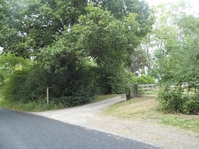
The copse is intersected by a network of well-maintained trails, allowing visitors to explore its natural beauty at their own pace. These paths wind through the forest, offering glimpses of wildlife such as deer, squirrels, and a variety of bird species. The chirping of birds and the rustling of leaves create a harmonious symphony that enhances the overall sensory experience.

Candles Copse is also home to a diverse range of plant species, including ferns, mosses, and lichens. These contribute to the copse's rich biodiversity, providing habitats for numerous insects and small animals. Additionally, the copse has a small stream that meanders through its grounds, adding to the overall charm and natural beauty of the area.

The copse's location in Surrey makes it easily accessible to visitors from nearby towns and cities. Its tranquil atmosphere and scenic surroundings make it a popular destination for nature walks, picnics, and photography. Whether it's a leisurely stroll or a peaceful retreat, Candles Copse offers an enchanting escape into nature for all who visit.

If you have any feedback on the listing, please let us know in the comments section below.

Candles Copse Images

Images are sourced within 2km of 51.135092/-0.53375338 or Grid Reference TQ0238. Thanks to Geograph Open Source API. All images are credited.

Old Milestone, was at Park Hatch, B2130, Dunsfold Road The milestone was located opposite the junction with Dunsfold Common Road, on the East side of the road on the verge beside the drive to the house. Parish of Dunsfold (Waverley district). Cast iron post, Guildford iron casting design, erected by Godalming & Painshill turnpike trust in the 19th century.

Inscription read:-  HORSHAM / 13  ::  GODALMING / 5  ::  BRIGHTON / 35

This image was taken before 2003 when the milestone was smashed by a flail and the remains later totally removed.

Milestone Society National ID: SY_HOGO13
Old Milestone, was at Park Hatch, B2130, Dunsfold Road
The milestone was located opposite the junction with Dunsfold Common Road, on the East side of the road on the verge beside the drive to the house. Parish of Dunsfold (Waverley district). Cast iron post, Guildford iron casting design, erected by Godalming & Painshill turnpike trust in the 19th century. Inscription read:- HORSHAM / 13 :: GODALMING / 5 :: BRIGHTON / 35 This image was taken before 2003 when the milestone was smashed by a flail and the remains later totally removed. Milestone Society National ID: SY_HOGO13
Woodland debris - Creek Copse Some of those look like beech mast - but I'm not an expert on seeds and fruit.
Woodland debris - Creek Copse
Some of those look like beech mast - but I'm not an expert on seeds and fruit.
Ride, Hascombe Hill
Ride, Hascombe Hill
Ride, Hascombe Hill
Ride, Hascombe Hill
Path, Hascombe Hill
Path, Hascombe Hill
Conifer plantation, Hascombe Hill
Narrow view south-east from Telegraph Hill Towards Dunsfold Aerodrome. Trees generally obscure views from the hill, which could not have been the case in telegraph days.
Narrow view south-east from Telegraph Hill
Towards Dunsfold Aerodrome. Trees generally obscure views from the hill, which could not have been the case in telegraph days.
Farm entrance on Alfold Road
Alfold Road south of Cranleigh
Solar Farm near Dunsfold Airfield The solar farm north of Dunsfold Airfield.
Solar Farm near Dunsfold Airfield
The solar farm north of Dunsfold Airfield.
View Towards Hascombe Looking down to the fields adjoining Hascombe Place Farm.
View Towards Hascombe
Looking down to the fields adjoining Hascombe Place Farm.
Bridleway on Nore Hanger Creek Copse is to the right of the path. 

The bridleway, initially, is easy walking; however, on the far side of the hill, the centre of the path appears to have been excavated to enable better drainage. As the channel is well over two feet deep, and not overly wide, I would have thought that riding a horse might be 'interesting'.
Bridleway on Nore Hanger
Creek Copse is to the right of the path. The bridleway, initially, is easy walking; however, on the far side of the hill, the centre of the path appears to have been excavated to enable better drainage. As the channel is well over two feet deep, and not overly wide, I would have thought that riding a horse might be 'interesting'.
Bridleway on Nore Hanger This bridleway runs along the ridge, before dropping off to the north.
Bridleway on Nore Hanger
This bridleway runs along the ridge, before dropping off to the north.
Bridleway on Nore Hanger The bridleway, at this location, is easy walking; however, further down the hill, the centre of the path appears to have been excavated to enable better drainage. As the channel is well over two feet deep, and not overly wide, I would have thought that riding a horse might be 'interesting'.
Bridleway on Nore Hanger
The bridleway, at this location, is easy walking; however, further down the hill, the centre of the path appears to have been excavated to enable better drainage. As the channel is well over two feet deep, and not overly wide, I would have thought that riding a horse might be 'interesting'.
Bridleway on Nore Hanger The bridleway, at this location, appears to have been excavated to enable better drainage. The channel is well over two feet deep.
Bridleway on Nore Hanger
The bridleway, at this location, appears to have been excavated to enable better drainage. The channel is well over two feet deep.
Footpath at Nore The path is located at the base of Hascombe Hill.
Footpath at Nore
The path is located at the base of Hascombe Hill.
View From Hascombe Hill Seen from the footpath at the base of the hill. Dunsfold Aerodrome is in the picture, to the left and centre, in the distance. Some of the buildings are just visible.
View From Hascombe Hill
Seen from the footpath at the base of the hill. Dunsfold Aerodrome is in the picture, to the left and centre, in the distance. Some of the buildings are just visible.
Nore Hanger Early evening sun, through the trees.
Nore Hanger
Early evening sun, through the trees.
Show me another place!

Candles Copse is located at Grid Ref: TQ0238 (Lat: 51.135092, Lng: -0.53375338)

Administrative County: Surrey

District: Waverley

Police Authority: Surrey

What 3 Words

///straddled.haggling.prefix. Near Cranleigh, Surrey

Related Wikis

Top Gear test track

The Top Gear test track is used by the BBC automotive television programme Top Gear. It is located at Dunsfold Aerodrome in Surrey, United Kingdom. The...

Hascombe Hill

Hascombe Hill or Hascombe Camp is the site of an Iron Age multivallate hill fort close to the village of Hascombe in Surrey, England. == History == The...

Dunsfold Aerodrome

Dunsfold Aerodrome (former ICAO code EGTD) is an unlicensed airfield in Surrey, England, near the village of Cranleigh. It extends across land in the villages...

London to Portsmouth canal

The London to Portsmouth canal was a concept for the construction of a secure inland canal route from the British capital of London to the headquarters...

Wey and Arun Canal

The Wey and Arun Canal is a partially open, 23-mile-long (37 km) canal in the southeast of England. It runs southwards from the River Wey at Gunsmouth...

Dunsfold

Dunsfold is a village in the borough of Waverley, Surrey, England, 8.7 miles (14.0 kilometres) south of Guildford. It lies in the Weald and reaches in...

Cranleigh railway station

Cranleigh was a railway station on the Cranleigh Line between Guildford and Horsham. It served the village of Cranleigh, Surrey in southern England....

Hascombe

Hascombe is a village and civil parish in Surrey, England. It is around 3 miles (4.8 km) southeast of Godalming in the Borough of Waverley. The settlement...

Nearby Amenities

Located within 500m of 51.135092,-0.53375338
Milestone
Lat/Long: 51.1330329/-0.5376738
Man Made: water_works
Lat/Long: 51.1312797/-0.5333604
The data included in this document is from www.openstreetmap.org. The data is made available under ODbL.

Have you been to Candles Copse?

Leave your review of Candles Copse below (or comments, questions and feedback).