Chitty's Common

Wood, Forest in Surrey Guildford

England

Chitty's Common

Junction of Stoughton Road and Scouts Lane
Junction of Stoughton Road and Scouts Lane Credit: Basher Eyre

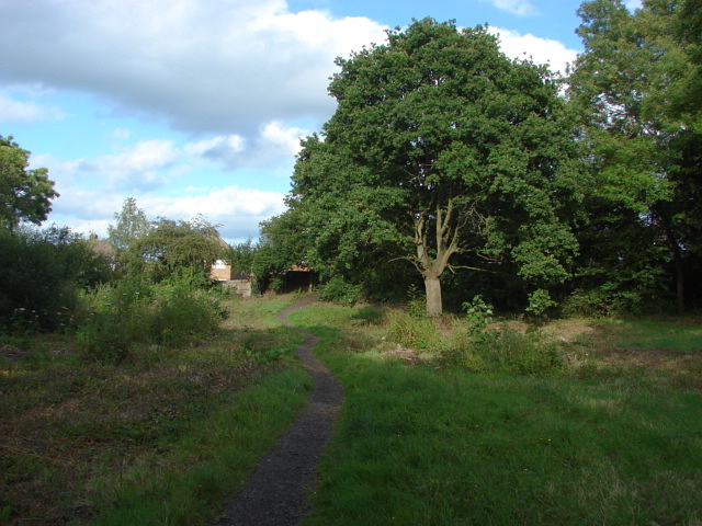
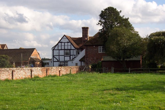
Chitty's Common, located in the county of Surrey in England, is a picturesque woodland area known for its natural beauty and tranquil atmosphere. Situated near the town of Wood, this forested common spans over a vast area, offering visitors a chance to immerse themselves in nature and enjoy a peaceful retreat from the bustling city life.

The common features a diverse range of vegetation, including ancient oak trees, dense thickets, and various wildflowers that bloom throughout the year. The woodland is a haven for wildlife, providing a habitat for numerous species of birds, mammals, and insects. Nature enthusiasts and birdwatchers often flock to Chitty's Common to observe the thriving wildlife in its natural habitat.

Visitors to Chitty's Common can explore the area through its well-maintained footpaths and walking trails, which wind their way through the dense forest. These trails offer opportunities for hiking, jogging, and dog walking, making it a popular destination for outdoor activities and exercise. The serene surroundings and fresh air make it an ideal spot for a leisurely picnic or a peaceful stroll.

Chitty's Common is also steeped in history, with evidence of human presence dating back centuries. The common has witnessed various historical events and is home to archaeological remains that shed light on the region's past. It serves as a reminder of the rich cultural heritage of the area.

Overall, Chitty's Common in Surrey is a natural gem that offers visitors a chance to connect with nature, enjoy outdoor activities, and explore the history of the region. With its scenic beauty and serene atmosphere, it is a popular destination for both locals and tourists seeking a peaceful escape.

If you have any feedback on the listing, please let us know in the comments section below.

Chitty's Common Images

Images are sourced within 2km of 51.260701/-0.59846928 or Grid Reference SU9752. Thanks to Geograph Open Source API. All images are credited.

Junction of Stoughton Road and Scouts Lane
Looking from Queens Drive into Stoughton Road
Queens Drive housing
Junction of Stoughton Road and Queens Drive
Looking from Stoughton Road into Scouts Lane
Lamppost at the junction of Stoughton Road and Scouts Lane Road lighting predates the earliest cars by thousands of years. In the 5th century BC, people in Beijing used bamboo pipes to harness and lead natural gas from volcano leaks to their communities which they then used to ignite lamps that  lit up their thoroughfares at night. 1417 marked the first organized public street lighting system in London. Its mayor, Sir Henry Barton, ordered people to place oil lanterns outside their homes at night during the winter. In 1802, William Murdoch invented the first coal-ignited gas lighting system and in 1879 Paris produced the world’s first electric streetlight system. A year later, Thomas Edison introduced the first carbon-thread incandescent lamp. By 1965 most systems used  high-pressure sodium (HID) lamps.  Today, street lighting commonly uses high-intensity discharge lamps. Milan, Italy is the first major city to have entirely switched to LED lighting
Lamppost at the junction of Stoughton Road and Scouts Lane
Road lighting predates the earliest cars by thousands of years. In the 5th century BC, people in Beijing used bamboo pipes to harness and lead natural gas from volcano leaks to their communities which they then used to ignite lamps that lit up their thoroughfares at night. 1417 marked the first organized public street lighting system in London. Its mayor, Sir Henry Barton, ordered people to place oil lanterns outside their homes at night during the winter. In 1802, William Murdoch invented the first coal-ignited gas lighting system and in 1879 Paris produced the world’s first electric streetlight system. A year later, Thomas Edison introduced the first carbon-thread incandescent lamp. By 1965 most systems used high-pressure sodium (HID) lamps. Today, street lighting commonly uses high-intensity discharge lamps. Milan, Italy is the first major city to have entirely switched to LED lighting
Looking over Stoughton Road towards Cardwells Keep
Stoughton Barracks: mid November 2021 Also see <span class="nowrap"><a title="https://www.mymalayagallery.co.uk/page92.html" rel="nofollow ugc noopener" href="https://www.mymalayagallery.co.uk/page92.html">Link</a><img style="margin-left:2px;" alt="External link" title="External link - shift click to open in new window" src="https://s1.geograph.org.uk/img/external.png" width="10" height="10"/></span>
Stoughton Barracks: mid November 2021
Also see LinkExternal link
Litter on the verge between Fir Tree Road and Cedar Way
Litter on the verge in Hazel Avenue
Litter on the verge in Oak Tree Drive
Litter on the verge in Larch Avenue
Narrowboats on the Wey
Line of Canada goslings
Houses overlooking the River Wey
House beside the River Wey
Boats and containers beside the Wey
Between bridges Bridges carrying the two carriageways of the A25 over the River Wey at Woodbridge.
Between bridges
Bridges carrying the two carriageways of the A25 over the River Wey at Woodbridge.
Show me another place!

Chitty's Common is located at Grid Ref: SU9752 (Lat: 51.260701, Lng: -0.59846928)

Administrative County: Surrey

District: Guildford

Police Authority: Surrey

What 3 Words

///enable.shirts.item. Near Fairlands, Surrey

Related Wikis

Chitty's Common

Chitty's Common is a 5-hectare (12-acre) nature reserve in Guildford in Surrey. It is owned by Surrey County Council and managed by the Surrey Wildlife...

Cycling UK

Cycling UK is a trading name of the Cyclists' Touring Club (CTC), which is a charitable membership organisation supporting cyclists and promoting bicycle...
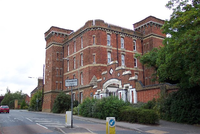
Stoughton Barracks

Stoughton Barracks was a military installation at Guildford in Surrey. == History == The barracks were built in the Fortress Gothic Revival Style and completed...

Fairlands

Fairlands is the largest settlement (neighbourhood) of Worplesdon, a village with a civil parish council in the Borough of Guildford, Surrey, England....

Nearby Amenities

Located within 500m of 51.260701,-0.59846928
Mini Roundabout
Direction: clockwise
Lat/Long: 51.2619271/-0.6040937
Crossing
Lat/Long: 51.2594934/-0.5951203
Bus Stop
Johnston Walk
Bench: yes
Bin: yes
Bus: yes
Naptan AtcoCode: 40004407995A
Naptan Bearing: SE
Naptan CommonName: Rosemary Crescent
Naptan Indicator: Just after
Naptan Landmark: Johnston Walk
Naptan NaptanCode: surawjwm
Naptan PlusbusZoneRef: GUILDFD
Naptan Street: Worplesdon Road
Naptan Verified: no
Public Transport: platform
Shelter: yes
Source: naptan_import
Lat/Long: 51.2597082/-0.5950472
Post Box
Collection Plate: CP1D
Collection Times: Mo-Fr 09:00; Sa 07:00
Last Checked: 2021-08-04
Old Ref: GU2 139
Operator: Royal Mail
Operator Wikidata: Q638098
Post Box Mounting: brick_pillar
Post Box Type: wall
Ref: GU2 139D
Royal Cypher: GR
Royal Cypher Wikidata: Q33102273
Source: survey
Lat/Long: 51.263379/-0.595736
Barrier: bollard
Lat/Long: 51.2632446/-0.5959425
Barrier: bollard
Lat/Long: 51.2590244/-0.5984423
Addr Housenumber: 2
Addr Street: Arbour Cottages
Lat/Long: 51.2587085/-0.6000638
Addr Housenumber: 27
Lat/Long: 51.2591423/-0.5965085
Addr Housenumber: 1
Addr Street: Bryanstone Avenue
Lat/Long: 51.2575444/-0.5960657
Addr Housenumber: 45
Lat/Long: 51.256426/-0.5976615
Addr Housenumber: 44
Lat/Long: 51.256673/-0.5975984
Addr Housenumber: 2
Lat/Long: 51.2568164/-0.5953581
Addr Housenumber: 91
Lat/Long: 51.2565863/-0.6002833
Addr Housenumber: 97
Lat/Long: 51.2571352/-0.5998673
Tarragon Court
Building: yes
Lat/Long: 51.263353/-0.5950847
Post Box
Collection Times: Mo-Fr 16:00; Sa 11:30
Drive Through: no
Operator: Royal Mail
Post Box Type: wall
Ref: GU2 235
Royal Cypher: GR
Royal Cypher Wikidata: Q33102273
Lat/Long: 51.2607017/-0.5932578
Post Box
Collection Times: Mo-Fr 09:00, Sa 07:00
Ref: GU2 210
Lat/Long: 51.2581876/-0.5991073
Bus Stop
Byrefield Road
Naptan AtcoCode: 40004407151A
Naptan Bearing: E
Naptan CommonName: Byrefield Road
Naptan Indicator: E-bound
Naptan Landmark: Byrefield Road
Naptan NaptanCode: surapdgd
Naptan PlusbusZoneRef: GUILDFD
Naptan Street: Byrefield Road
Naptan Verified: yes
Public Transport: platform
Source: naptan_import
Lat/Long: 51.2567729/-0.5950605
Bus Stop
Pitch Place
Bench: no
Naptan AtcoCode: 40004407172A
Naptan Bearing: NW
Naptan CommonName: Pitch Place
Naptan Indicator: adj
Naptan Landmark: Pitch Place
Naptan NaptanCode: surapdwg
Naptan PlusbusZoneRef: GUILDFD
Naptan Street: Worplesdon Road
Naptan Verified: yes
Public Transport: platform
Shelter: no
Source: naptan_import
Tactile Paving: no
Lat/Long: 51.2643195/-0.5975831
Bus Stop
Pitch Place
Naptan AtcoCode: 40004407172B
Naptan Bearing: SE
Naptan CommonName: Pitch Place
Naptan Indicator: Opp
Naptan Landmark: Pitch Place
Naptan NaptanCode: surapdwj
Naptan PlusbusZoneRef: GUILDFD
Naptan Street: Worplesdon Road
Naptan Verified: no
Public Transport: platform
Source: naptan_import
Lat/Long: 51.2637242/-0.5970576
Bus Stop
Johnston Walk
Bus: yes
Naptan AtcoCode: 40004407173A
Naptan Bearing: N
Naptan CommonName: Johnston Walk
Naptan Indicator: Just Before
Naptan Landmark: Bryanstone Avenue
Naptan NaptanCode: surapdwm
Naptan PlusbusZoneRef: GUILDFD
Naptan Street: Worplesdon Road
Naptan Verified: no
Public Transport: platform
Source: naptan_import
Lat/Long: 51.2588432/-0.5951429
Bus Stop
Johnston Walk
Bus: yes
Naptan AtcoCode: 40004407173B
Naptan Bearing: S
Naptan CommonName: Johnston Walk
Naptan Indicator: adj
Naptan Landmark: Bryanstone Avenue
Naptan NaptanCode: surapdwp
Naptan PlusbusZoneRef: GUILDFD
Naptan Street: Worplesdon Road
Naptan Verified: no
Public Transport: platform
Source: naptan_import
Lat/Long: 51.2589647/-0.5949959
Bus Stop
Tarragon Court
Bench: yes
Bin: yes
Naptan AtcoCode: 40004407177A
Naptan Bearing: SW
Naptan CommonName: Tarragon Court
Naptan Indicator: Just after
Naptan Landmark: Tarragon Court
Naptan NaptanCode: surapgat
Naptan PlusbusZoneRef: GUILDFD
Naptan Street: Cumberland Avenue
Naptan Verified: yes
Public Transport: platform
Shelter: yes
Source: naptan_import
Lat/Long: 51.2632844/-0.5958075
Bus Stop
Tarragon Court
Bench: yes
Bin: yes
Naptan AtcoCode: 40004407177B
Naptan Bearing: NE
Naptan CommonName: Tarragon Court
Naptan Indicator: Just Before
Naptan Landmark: Tarragon Court
Naptan NaptanCode: surapgaw
Naptan PlusbusZoneRef: GUILDFD
Naptan Street: Cumberland Avenue
Naptan Verified: yes
Public Transport: platform
Shelter: yes
Source: naptan_import;visual_estimate
Lat/Long: 51.2634512/-0.5958078
Bus Stop
Rosemary Crescent
Naptan AtcoCode: 40004407995B
Naptan Bearing: NW
Naptan CommonName: Rosemary Crescent
Naptan Indicator: Just Before
Naptan Landmark: Rosemary Crescent
Naptan NaptanCode: surawjwp
Naptan PlusbusZoneRef: GUILDFD
Naptan Street: Worplesdon Road
Naptan Verified: no
Public Transport: platform
Source: naptan_import
Lat/Long: 51.2606487/-0.5956332
Crossing
Button Operated: yes
Crossing: traffic_signals
Crossing Island: no
Crossing Markings: zebra
Tactile Paving: yes
Traffic Signals Sound: yes
Lat/Long: 51.2594414/-0.5951203
Pitch Place Farm
Landuse: farm
Note Retag: CS #48756035
Source Shape: os_street_view
Lat/Long: 51.2635982/-0.6003293
Addr Housenumber: 54
Lat/Long: 51.2573392/-0.5991902
Addr Housenumber: 91A
Lat/Long: 51.2566733/-0.6003211
Addr Housenumber: 98
Source: extrapolation
Lat/Long: 51.2588357/-0.5981874
Addr Housenumber: 113
Lat/Long: 51.2580505/-0.5994218
Addr Housenumber: 109
Lat/Long: 51.2578306/-0.5998429
Addr Housenumber: 111
Lat/Long: 51.2578797/-0.5998255
Addr Housenumber: 81
Lat/Long: 51.256365/-0.6003417
Addr Housenumber: 54A
Addr Street: Rydes Hill Road
Lat/Long: 51.2569643/-0.5995895
Addr Housenumber: 95
Lat/Long: 51.2569311/-0.600534
Addr Housenumber: 74
Lat/Long: 51.2580114/-0.5987398
Addr Housenumber: 2
Lat/Long: 51.2572968/-0.6003982
Addr Housenumber: 1
Lat/Long: 51.257065/-0.6007721
Addr Housenumber: 19A
Lat/Long: 51.2581873/-0.6008628
Addr Housenumber: 4
Lat/Long: 51.2573808/-0.6004091
Addr Housenumber: 3
Lat/Long: 51.2571991/-0.6008338
Addr Housenumber: 21
Lat/Long: 51.2583304/-0.6009463
Addr Housenumber: 20
Lat/Long: 51.2582668/-0.6003583
Addr Housenumber: 72
Lat/Long: 51.2579485/-0.5987819
Addr Housenumber: 23
Lat/Long: 51.2574062/-0.5985148
Addr Housenumber: 4
Lat/Long: 51.2573415/-0.5956449
Addr Housenumber: 21
Lat/Long: 51.2574116/-0.5983957
Addr Housenumber: 80
Lat/Long: 51.2566238/-0.5996228
Addr Housenumber: 78
Lat/Long: 51.2566147/-0.5995212
Addr Housenumber: 4
Lat/Long: 51.2568119/-0.5954277
Addr Housenumber: 3
Lat/Long: 51.2575187/-0.5970643
Addr Housenumber: 47
Lat/Long: 51.2564097/-0.5978667
Addr Housenumber: 2
Lat/Long: 51.2575222/-0.5965782
Addr Housenumber: 81
Lat/Long: 51.2563901/-0.5999999
Addr Housenumber: 25
Lat/Long: 51.257388/-0.598779
Addr Housenumber: 4
Lat/Long: 51.2575934/-0.5966061
Addr Housenumber: 82
Source: extrapolation
Lat/Long: 51.2566465/-0.5997716
Addr Housenumber: 72
Lat/Long: 51.2571045/-0.5995486
Addr Housenumber: 23A
Lat/Long: 51.2574116/-0.5986396
Addr Housenumber: 2
Lat/Long: 51.2573528/-0.5955614
Addr Housenumber: 161
Lat/Long: 51.2573861/-0.594998
Addr Housenumber: 208
Lat/Long: 51.2570403/-0.5943332
Addr Housenumber: 246
Lat/Long: 51.2583371/-0.5946588
Addr Housenumber: 149
Lat/Long: 51.2568788/-0.5947811
Addr Housenumber: 244
Lat/Long: 51.2582894/-0.5946216
Addr Housenumber: 181
Lat/Long: 51.2584259/-0.5952313
Addr Housenumber: 163
Lat/Long: 51.2576018/-0.5949775
Addr Housenumber: 210
Lat/Long: 51.2570895/-0.5943445
Power: substation
Lat/Long: 51.2575558/-0.595473
Addr Housenumber: 2
Lat/Long: 51.2592054/-0.6000099
Addr Housenumber: 119
Lat/Long: 51.2581443/-0.5998338
Addr Housenumber: 6
Lat/Long: 51.2589368/-0.6000215
Addr Housenumber: 129
Source: interpolation
Lat/Long: 51.258554/-0.600144
Addr Housenumber: 4
Lat/Long: 51.2592036/-0.600195
Addr Housenumber: 1
Lat/Long: 51.2586611/-0.6000788
Addr Housenumber: 123
Source: extrapolation
Lat/Long: 51.258141/-0.6000917
Addr Housenumber: 117
Lat/Long: 51.2581171/-0.5997506
Addr Housenumber: 1
Lat/Long: 51.2590196/-0.6002133
Addr Housenumber: 92
Lat/Long: 51.25863/-0.5983253
Addr Housenumber: 6
Lat/Long: 51.2587484/-0.6011235
Addr Housenumber: 26
Lat/Long: 51.2601183/-0.6004996
Addr Housenumber: 11
Lat/Long: 51.2589834/-0.6009913
Addr Housenumber: 21
Lat/Long: 51.2598468/-0.6006037
Addr Housenumber: 5
Lat/Long: 51.2589852/-0.6005632
Addr Housenumber: 90
Source: interpolation
Lat/Long: 51.2585684/-0.5983666
Addr Housenumber: 31
Lat/Long: 51.2599554/-0.6009971
Addr Housenumber: 28
Source: extrapolation
Lat/Long: 51.260169/-0.6005604
Addr Housenumber: 80
Source: interpolation
Lat/Long: 51.2582425/-0.5986208
Addr Housenumber: 1
Lat/Long: 51.258762/-0.6006137
Addr Housenumber: 17
Lat/Long: 51.2592422/-0.6011186
Addr Housenumber: 35
Lat/Long: 51.2601653/-0.6008467
Addr Housenumber: 7
Lat/Long: 51.2589562/-0.6006992
Addr Housenumber: 14
Lat/Long: 51.2595825/-0.6006211
Addr Housenumber: 14
Lat/Long: 51.2615348/-0.6008624
Addr Housenumber: 7
Lat/Long: 51.2610296/-0.599665
Addr Housenumber: 5
Lat/Long: 51.2611989/-0.6008827
Addr Housenumber: 41
Lat/Long: 51.2618688/-0.6004262
Addr Housenumber: 1
Lat/Long: 51.2609595/-0.6011047
Addr Housenumber: 17
Lat/Long: 51.2607237/-0.6009205
Addr Housenumber: 16
Lat/Long: 51.2602989/-0.5995349
Addr Housenumber: 1
Lat/Long: 51.2612068/-0.6001389
Addr Housenumber: 13
Lat/Long: 51.2614767/-0.5997347
Addr Housenumber: 19
Addr Street: Keens Park Road
Lat/Long: 51.2606658/-0.6013648
Addr Housenumber: 3
Addr Street: Keens Park Road
Lat/Long: 51.2615219/-0.6000847
Addr Housenumber: 28
Lat/Long: 51.260881/-0.6002222
Addr Housenumber: 2
Lat/Long: 51.2611779/-0.6000259
Addr Housenumber: 8
Lat/Long: 51.2614658/-0.5992748
Addr Housenumber: 9
Lat/Long: 51.2604627/-0.601384
Addr Housenumber: 18
Lat/Long: 51.2615189/-0.6012049
Addr Housenumber: 6
Lat/Long: 51.2610585/-0.5997742
Addr Housenumber: 1
Addr Street: Keens Park Road
Lat/Long: 51.261834/-0.5999915
Addr Housenumber: 1
Lat/Long: 51.2604203/-0.6005027
Addr Housenumber: 13
Lat/Long: 51.261655/-0.6005986
Addr Housenumber: 47
Lat/Long: 51.2618549/-0.6007705
Addr Housenumber: 4
Lat/Long: 51.2610663/-0.6012494
Addr Housenumber: 8
Lat/Long: 51.2607956/-0.5994909
Addr Housenumber: 25
Addr Street: Keens Lane
Lat/Long: 51.2620891/-0.5993182
Addr Housenumber: 12
Lat/Long: 51.2614712/-0.5995727
Addr Housenumber: 9
Lat/Long: 51.260841/-0.600629
Addr Housenumber: 7
Addr Street: Keens Park Road
Note: FIXME I did not notice, but it makes sense that 7 in here
Source: interpolation
Lat/Long: 51.2610043/-0.6004867
Addr Housenumber: 17
Lat/Long: 51.2602946/-0.5999561
Addr Housenumber: 5
Addr Street: Keens Park Road
Lat/Long: 51.2612358/-0.6002296
Addr Housenumber: 17
Lat/Long: 51.2615056/-0.6000239
Addr Housenumber: 11
Lat/Long: 51.2606223/-0.601381
Addr Housenumber: 31
Lat/Long: 51.2609678/-0.6004018
Addr Housenumber: 4
Lat/Long: 51.261084/-0.5998612
Addr Housenumber: 7
Lat/Long: 51.2618875/-0.5995091
Addr Housenumber: 8
Lat/Long: 51.2603524/-0.6013072
Addr Housenumber: 185
Lat/Long: 51.2586117/-0.5954633
Addr Housenumber: 3
Lat/Long: 51.2577364/-0.5960861
Addr Housenumber: 201
Lat/Long: 51.2594606/-0.5953164
Addr Housenumber: 53
Lat/Long: 51.2601755/-0.5964368
Addr Housenumber: 26
Lat/Long: 51.2586244/-0.5979674
Addr Housenumber: 292
Lat/Long: 51.2606478/-0.5949998
Addr Housenumber: 269
Lat/Long: 51.2620013/-0.5963512
Addr Housenumber: 287
Lat/Long: 51.262499/-0.5966083
Addr Housenumber: 276
Lat/Long: 51.2596545/-0.5945703
Addr Housenumber: 36
Lat/Long: 51.2588315/-0.5973715
Addr Housenumber: 29
Lat/Long: 51.2591121/-0.5959704
Addr Housenumber: 16
Lat/Long: 51.2611656/-0.5972081
Addr Housenumber: 17a
Lat/Long: 51.2585668/-0.5959234
Addr Housenumber: 291
Lat/Long: 51.2626091/-0.5966601
Addr Housenumber: 32
Lat/Long: 51.2589093/-0.5968942
Addr Housenumber: 27
Lat/Long: 51.2590532/-0.5963826
Addr Housenumber: 3
Lat/Long: 51.2619112/-0.5969716
Addr Housenumber: 15a
Lat/Long: 51.2583201/-0.5959306
Addr Housenumber: 30
Lat/Long: 51.2591137/-0.5980261
Addr Housenumber: 203
Lat/Long: 51.2618163/-0.5962745
Addr Housenumber: 25
Lat/Long: 51.2589695/-0.596397
Addr Housenumber: 8
Lat/Long: 51.2577703/-0.5966501
Addr Housenumber: 17
Lat/Long: 51.2579993/-0.5982973
Addr Housenumber: 280
Lat/Long: 51.2601317/-0.5947351
Addr Housenumber: 201
Lat/Long: 51.2617766/-0.5962579
Addr Housenumber: 290
Lat/Long: 51.2605884/-0.5949766
Addr Housenumber: 278
Lat/Long: 51.2597093/-0.59453
Addr Housenumber: 203
Lat/Long: 51.259527/-0.5953415
Addr Housenumber: 40
Lat/Long: 51.2588278/-0.5976549
Addr Housenumber: 241
Lat/Long: 51.2608774/-0.5958525
Addr Housenumber: 31
Lat/Long: 51.2593157/-0.5960789
Addr Housenumber: 17
Lat/Long: 51.2585396/-0.5962596
Addr Housenumber: 289
Lat/Long: 51.2625453/-0.5966361
Addr Housenumber: 34
Lat/Long: 51.2590197/-0.5968971
Addr Housenumber: 27a
Lat/Long: 51.2590894/-0.5961909
Addr Housenumber: 6
Lat/Long: 51.2618683/-0.597232
Addr Housenumber: 7
Lat/Long: 51.2616362/-0.597259
Addr Housenumber: 15b
Lat/Long: 51.2583337/-0.5958402
Addr Housenumber: 27
Lat/Long: 51.2589157/-0.5981211
Addr Housenumber: 183
Lat/Long: 51.2585523/-0.5954327
Addr Housenumber: 15
Lat/Long: 51.2583315/-0.5962379
Addr Housenumber: 1
Lat/Long: 51.258647/-0.5976013
Addr Housenumber: 18
Lat/Long: 51.2580672/-0.5982973
Claron
Addr Street: Rosemary Crescent
Building: yes
Note: FIXME check 10 and Claron are not swapped
Lat/Long: 51.2602089/-0.5976472
Addr Housenumber: 2
Lat/Long: 51.2606081/-0.5967585
Addr Housenumber: 10
Lat/Long: 51.2598737/-0.5973987
Addr Housenumber: 9
Lat/Long: 51.260599/-0.5974635
Addr Housenumber: 11
Lat/Long: 51.2603124/-0.5976183
Addr Housenumber: 12
Lat/Long: 51.2598646/-0.5977024
Addr Housenumber: 10
Addr Street: Rosemary Crescent
Note: FIXME check 10 and Claron are not swapped
Lat/Long: 51.2602669/-0.5978439
Addr Housenumber: 1
Lat/Long: 51.2607167/-0.5967404
Addr Housenumber: 19
Lat/Long: 51.2609565/-0.5963716
Addr Housenumber: 2a
Lat/Long: 51.2605402/-0.5965921
Addr Housenumber: 1
Lat/Long: 51.2592175/-0.5973119
Addr Housenumber: 20
Lat/Long: 51.2592537/-0.5977168
Board Type: notice
Information: board
Tourism: information
Lat/Long: 51.2622292/-0.5984255
Bench
Lat/Long: 51.2622086/-0.5984356
Board Type: nature
Information: board
Lat/Long: 51.2591778/-0.5996168
Addr Housenumber: 6
Lat/Long: 51.2580591/-0.5937955
Addr Housenumber: 6
Lat/Long: 51.2580472/-0.592852
Addr Housenumber: 4
Lat/Long: 51.2581556/-0.5938982
Addr Housenumber: 2
Lat/Long: 51.2580302/-0.5930096
Addr Housenumber: 3
Lat/Long: 51.2578985/-0.5932348
Addr Housenumber: 4
Addr Street: Thornton Close
Lat/Long: 51.2581711/-0.5942151
Addr Housenumber: 2
Lat/Long: 51.258175/-0.5939737
Addr Housenumber: 23
Lat/Long: 51.2583675/-0.5924141
Addr Housenumber: 1
Lat/Long: 51.2579874/-0.5932718
Addr Housenumber: 2
Addr Street: Thornton Close
Lat/Long: 51.2581282/-0.5945747
Addr Housenumber: 20
Lat/Long: 51.2574752/-0.5935537
Addr Housenumber: 3
Lat/Long: 51.258275/-0.5933249
Addr Housenumber: 1
Lat/Long: 51.2582652/-0.593393
Addr Housenumber: 20A
Lat/Long: 51.2590579/-0.5941119
Addr Housenumber: 1
Lat/Long: 51.2583947/-0.5941304
Addr Housenumber: 34A
Lat/Long: 51.2593655/-0.5948196
Addr Housenumber: 11
Lat/Long: 51.2587163/-0.5942161
Addr Housenumber: 30A
Lat/Long: 51.2592496/-0.594572
Addr Housenumber: 26
Lat/Long: 51.2592243/-0.5943105
Addr Housenumber: 7
Lat/Long: 51.2585348/-0.5942044
Addr Housenumber: 34
Lat/Long: 51.2593451/-0.5948196
Addr Housenumber: 20
Lat/Long: 51.2590287/-0.5940886
Addr Housenumber: 32
Lat/Long: 51.259273/-0.5948087
Addr Housenumber: 30
Lat/Long: 51.2592496/-0.5945253
Addr Housenumber: 9
Lat/Long: 51.258648/-0.5941966
Addr Housenumber: 242
Lat/Long: 51.2580763/-0.5945724
Addr Housenumber: 17
Lat/Long: 51.2613811/-0.5931639
Addr Housenumber: 48
Lat/Long: 51.2615489/-0.591948
Addr Housenumber: 12
Lat/Long: 51.2617307/-0.5930678
Addr Housenumber: 1
Lat/Long: 51.2616177/-0.5924874
Addr Housenumber: 17
Lat/Long: 51.2608005/-0.593701
Addr Housenumber: 1
Lat/Long: 51.2620353/-0.5920591
Addr Housenumber: 260
Lat/Long: 51.2591059/-0.5948591
Addr Housenumber: 252
Lat/Long: 51.2586538/-0.5947153
Addr Housenumber: 13
Lat/Long: 51.2616465/-0.5931062
Addr Housenumber: 27
Lat/Long: 51.2610373/-0.5933348
Addr Housenumber: 20
Lat/Long: 51.2603984/-0.5934864
Addr Housenumber: 258
Lat/Long: 51.2590103/-0.5947789
Addr Housenumber: 18
Lat/Long: 51.2603317/-0.5936363
Addr Housenumber: 11
Lat/Long: 51.2606448/-0.5939219
Addr Housenumber: 270
Lat/Long: 51.2595688/-0.5946634
Addr Housenumber: 177
Lat/Long: 51.261481/-0.5914365
Note: FIXME is number 264 here?
Source: extrapolation
Lat/Long: 51.2594845/-0.5947527
Addr Housenumber: 20
Lat/Long: 51.2613811/-0.5927898
Addr Housenumber: 33
Lat/Long: 51.2611853/-0.5931015
Addr Housenumber: 9
Lat/Long: 51.2618798/-0.5930076
Addr Housenumber: 272
Lat/Long: 51.2596377/-0.5945885
Addr Housenumber: 8
Lat/Long: 51.2619335/-0.592791
Addr Housenumber: 15
Lat/Long: 51.2607512/-0.5937612
Addr Housenumber: 2
Lat/Long: 51.2597922/-0.5944443
Addr Housenumber: 1
Lat/Long: 51.2602668/-0.5944982
Addr Housenumber: 266
Lat/Long: 51.2594973/-0.5947411
Addr Housenumber: 19
Lat/Long: 51.2613034/-0.5930153
Addr Housenumber: 19
Lat/Long: 51.2608536/-0.5936222
Addr Housenumber: 50
Lat/Long: 51.2616008/-0.5918985
Addr Housenumber: 4
Lat/Long: 51.2598376/-0.5943671
Addr Housenumber: 4
Lat/Long: 51.2617868/-0.5924195
Addr Housenumber: 3
Lat/Long: 51.260317/-0.594421
Addr Housenumber: 176
Lat/Long: 51.2615236/-0.5915566
Addr Housenumber: 2
Lat/Long: 51.2619576/-0.5917721
Addr Housenumber: 24
Lat/Long: 51.2615431/-0.5925745
Addr Housenumber: 16
Lat/Long: 51.2614741/-0.5931421
Addr Housenumber: 5
Lat/Long: 51.2618903/-0.5925335
Addr Housenumber: 22
Lat/Long: 51.2607506/-0.5929516
Addr Housenumber: 17
Lat/Long: 51.2604413/-0.5920304
Addr Housenumber: 13
Lat/Long: 51.2603248/-0.5923467
Addr Housenumber: 56
Lat/Long: 51.2592737/-0.5924353
Addr Housenumber: 78
Lat/Long: 51.2599065/-0.5922427
Addr Housenumber: 2
Lat/Long: 51.2599536/-0.5921434
Addr Housenumber: 15
Lat/Long: 51.2603536/-0.5921885
Addr Housenumber: 115
Source: interpolation
Lat/Long: 51.2595426/-0.5935822
Addr Housenumber: 1
Lat/Long: 51.2606894/-0.5929393
Addr Housenumber: 4
Lat/Long: 51.2599877/-0.5920874
Addr Housenumber: 143
Lat/Long: 51.2603996/-0.5933854
Addr Housenumber: 131
Lat/Long: 51.2600095/-0.5927958
Addr Housenumber: 3
Lat/Long: 51.2605816/-0.5928572
Addr Housenumber: 42
Lat/Long: 51.2595267/-0.5917365
Addr Housenumber: 34
Lat/Long: 51.2598988/-0.5915343
Bicycle Parking
Spaces: 2
Lat/Long: 51.2617115/-0.5918507
Addr Housenumber: 19
Lat/Long: 51.2605315/-0.5918682
Addr Housenumber: 17A
Lat/Long: 51.2604726/-0.5919623
Addr Housenumber: 109
Source: interpolation
Lat/Long: 51.2592717/-0.5934121
Addr Housenumber: 99
Lat/Long: 51.2590126/-0.5928123
Addr Housenumber: 20
Lat/Long: 51.2603692/-0.5913743
Addr Housenumber: 101
Lat/Long: 51.2590427/-0.5929036
Addr Housenumber: 15A
Lat/Long: 51.2603887/-0.5921124
Addr Housenumber: 89
Source: interpolation
Lat/Long: 51.258827/-0.5921558
Addr Housenumber: 76
Lat/Long: 51.2598734/-0.5923004
Traffic Calming: bump
Lat/Long: 51.2634372/-0.595694
Traffic Calming: bump
Lat/Long: 51.2631253/-0.5961671
Traffic Calming: bump
Lat/Long: 51.2640861/-0.5951282
Traffic Calming: bump
Lat/Long: 51.2644254/-0.5948062
Addr Housenumber: 91
Source: visual_estimate
Lat/Long: 51.2617412/-0.6033419
Source: visual_estimate
Lat/Long: 51.2610737/-0.6041715
Addr Housenumber: 1
Source: visual_estimate
Lat/Long: 51.261437/-0.6032607
Sidney Court
Addr Housename: Sidney Court
Building: yes
Lat/Long: 51.2618165/-0.6038056
Addr Housenumber: 21
Source: visual_estimate
Lat/Long: 51.2615167/-0.6039925
Addr Housenumber: 20
Source: visual_estimate
Lat/Long: 51.2613947/-0.6040362
Source: visual_estimate
Lat/Long: 51.2609965/-0.6033959
Addr Housenumber: 103
Lat/Long: 51.2591008/-0.5930325
Addr Housenumber: 105
Lat/Long: 51.2591617/-0.5931679
Addr Housenumber: 107
Lat/Long: 51.2592101/-0.5932754
Bench
Backrest: yes
Material: plastic
Seats: 3
Lat/Long: 51.2644104/-0.5980453
Addr Housenumber: 26
Lat/Long: 51.2608766/-0.5927741
Addr Housenumber: 28
Lat/Long: 51.2609363/-0.59269
Addr City: Guildford
Addr Housenumber: 36
Addr Street: Johnston Walk
Lat/Long: 51.2611388/-0.5924047
Addr City: Guildford
Addr Postcode: GU2 9XR
Addr Street: Johnston Walk
Source Addr Postcode: companies house opendata
Lat/Long: 51.2611877/-0.5923358
Bench
Lat/Long: 51.2615187/-0.5950624
Addr Housename: 6
Lat/Long: 51.2600456/-0.5919955
Addr Housename: 8
Lat/Long: 51.2600846/-0.5919333
Barrier: bollard
Motor Vehicle: no
Lat/Long: 51.2621434/-0.6004051
Barrier: bollard
Motor Vehicle: no
Lat/Long: 51.2620275/-0.6010331
Crossing
Crossing: uncontrolled
Crossing Island: yes
Crossing Markings: zebra
Lat/Long: 51.2627474/-0.5965
Addr Housename: 25
Lat/Long: 51.2619589/-0.6047545
Addr Housename: 29
Lat/Long: 51.2622084/-0.604123
Addr Housename: 34
Lat/Long: 51.2627244/-0.6036503
Addr Housename: 35
Lat/Long: 51.2628542/-0.6034951
Addr Housename: 21
Lat/Long: 51.2617625/-0.6053853
Addr Housename: 22
Lat/Long: 51.261813/-0.6052229
Addr Housename: 23
Lat/Long: 51.2618605/-0.6050703
Addr Housename: 24
Lat/Long: 51.261903/-0.6049339
Addr Housename: 26
Lat/Long: 51.2620112/-0.6046428
Addr Housename: 27
Lat/Long: 51.2620685/-0.6044691
Addr Housename: 28
Lat/Long: 51.2621235/-0.604333
Addr Housename: 30
Lat/Long: 51.2623297/-0.6040119
Addr Housename: 31
Lat/Long: 51.2624118/-0.6039367
Addr Housename: 32
Lat/Long: 51.2625106/-0.6038461
Addr Housename: 33
Lat/Long: 51.2626175/-0.6037482
Man Made: manhole
Manhole: drain
Lat/Long: 51.260215/-0.5920063
Grit Bin
Lat/Long: 51.260043/-0.5924983
The data included in this document is from www.openstreetmap.org. The data is made available under ODbL.

Have you been to Chitty's Common?

Leave your review of Chitty's Common below (or comments, questions and feedback).