Eight Acre Copse

Wood, Forest in Surrey Waverley

England

Eight Acre Copse

Ridgley Road at the junction of Coxcomb Lane
Ridgley Road at the junction of Coxcomb Lane Credit: David Howard

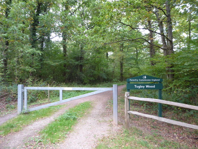
Eight Acre Copse is a picturesque woodland located in Surrey, England. Situated in the heart of the Surrey Hills Area of Outstanding Natural Beauty, this serene copse covers an area of approximately eight acres, as its name suggests. It is a popular destination for nature enthusiasts, hikers, and those seeking solace in the tranquil surroundings of a forested landscape.

The copse is characterized by its lush greenery and diverse flora and fauna. Tall, majestic oak trees dominate the woodland, providing a canopy that offers shade in the summer months. In addition to oaks, other tree species such as beech, birch, and ash can be found, creating a rich tapestry of colors during the autumn season. The forest floor is covered with a thick layer of moss, ferns, and bluebells, adding to the enchanting atmosphere of the copse.

Eight Acre Copse is home to a variety of wildlife, including deer, foxes, squirrels, and numerous bird species. It serves as an important habitat for these animals, providing shelter and sustenance. Birdwatchers can spot species such as woodpeckers, thrushes, and owls within the copse, making it a haven for avian enthusiasts.

The copse offers a network of well-maintained trails, allowing visitors to explore its natural beauty at their leisure. These paths wind through the woodland, providing opportunities for walking, jogging, or simply enjoying a peaceful stroll. The copse also has designated picnic areas, making it an ideal spot for families and friends to gather and enjoy a meal amidst the tranquility of nature.

Overall, Eight Acre Copse is a stunning woodland that encapsulates the beauty and serenity of the Surrey countryside. With its diverse ecosystem, well-maintained trails, and abundant wildlife, it offers a delightful escape from the busyness of modern life.

If you have any feedback on the listing, please let us know in the comments section below.

Eight Acre Copse Images

Images are sourced within 2km of 51.104194/-0.60893499 or Grid Reference SU9734. Thanks to Geograph Open Source API. All images are credited.

Ridgley Road at the junction of Coxcomb Lane
Shops on The Green, Chiddingfold
Shops on The Green, Chiddingfold A very small Boots, one of the few large chains who kept their village shops as well.
Shops on The Green, Chiddingfold
A very small Boots, one of the few large chains who kept their village shops as well.
House on The Green, Chiddingfold
The Winterton Arms, Chiddingfold
Houses on Petworth Road, Chiddingfold
Petworth Road, Chiddingfold
Old house on Petworth Road, Chiddingfold
Exploring eastwards along the Bashire (6) Looking from Shillinglee Park Road into Pickhurst Road
Running total: 25 B points
Exploring eastwards along the Bashire (6)
Looking from Shillinglee Park Road into Pickhurst Road Running total: 25 B points
Exploring eastwards along the Bashire (7) Footpath sign opposite Robin Farm Racing Stables
Exploring eastwards along the Bashire (7)
Footpath sign opposite Robin Farm Racing Stables
Exploring eastwards along the Bashire (8) Entrance to Tugley Wood
Running total: 27 B points
Exploring eastwards along the Bashire (8)
Entrance to Tugley Wood Running total: 27 B points
Entering Chiddingfold, A283 Chiddingfold is a village and civil parish in the heart of The Weald in the Waverley district of Surrey. It lies on the A283 between Milford and Petworth.
Wikipedia: <span class="nowrap"><a title="http://en.wikipedia.org/wiki/Chiddingfold" rel="nofollow ugc noopener" href="http://en.wikipedia.org/wiki/Chiddingfold">Link</a><img style="margin-left:2px;" alt="External link" title="External link - shift click to open in new window" src="https://s1.geograph.org.uk/img/external.png" width="10" height="10"/></span>
Entering Chiddingfold, A283
Chiddingfold is a village and civil parish in the heart of The Weald in the Waverley district of Surrey. It lies on the A283 between Milford and Petworth. Wikipedia: LinkExternal link
A283, Chiddingfold The A283 runs 37 miles from Milford near Guildford south to Shoreham-on-Sea across rural Surrey and West Sussex.
<span class="nowrap"><a title="https://www.sabre-roads.org.uk/wiki/index.php?title=A283" rel="nofollow ugc noopener" href="https://www.sabre-roads.org.uk/wiki/index.php?title=A283">Link</a><img style="margin-left:2px;" alt="External link" title="External link - shift click to open in new window" src="https://s1.geograph.org.uk/img/external.png" width="10" height="10"/></span>
A283, Chiddingfold
The A283 runs 37 miles from Milford near Guildford south to Shoreham-on-Sea across rural Surrey and West Sussex. LinkExternal link
The Swan Inn
The Swan Inn
Church of St Mary Chiddingfold is a village and civil parish in the heart of The Weald in the Waverley district of Surrey. It lies on the A283 between Milford and Petworth.
Wikipedia: <span class="nowrap"><a title="http://en.wikipedia.org/wiki/Chiddingfold" rel="nofollow ugc noopener" href="http://en.wikipedia.org/wiki/Chiddingfold">Link</a><img style="margin-left:2px;" alt="External link" title="External link - shift click to open in new window" src="https://s1.geograph.org.uk/img/external.png" width="10" height="10"/></span>
Church of St Mary
Chiddingfold is a village and civil parish in the heart of The Weald in the Waverley district of Surrey. It lies on the A283 between Milford and Petworth. Wikipedia: LinkExternal link
A283 at The Winterton Arms The A283 runs 37 miles from Milford near Guildford south to Shoreham-on-Sea across rural Surrey and West Sussex.
<span class="nowrap"><a title="https://www.sabre-roads.org.uk/wiki/index.php?title=A283" rel="nofollow ugc noopener" href="https://www.sabre-roads.org.uk/wiki/index.php?title=A283">Link</a><img style="margin-left:2px;" alt="External link" title="External link - shift click to open in new window" src="https://s1.geograph.org.uk/img/external.png" width="10" height="10"/></span>
A283 at The Winterton Arms
The A283 runs 37 miles from Milford near Guildford south to Shoreham-on-Sea across rural Surrey and West Sussex. LinkExternal link
Show me another place!

Eight Acre Copse is located at Grid Ref: SU9734 (Lat: 51.104194, Lng: -0.60893499)

Administrative County: Surrey

District: Waverley

Police Authority: Surrey

What 3 Words

///detail.buying.exulted. Near Chiddingfold, Surrey

Related Wikis

Pickhurst

Pickhurst is a grade II* listed house set in 130 acres (53 ha) of land near Chiddingfold, Surrey, England. == History == It was designed by the Scottish...

Chiddingfold

Chiddingfold is a village and civil parish in the Weald in the Waverley district of Surrey, England. It lies on the A283 road between Milford and Petworth...

The Farm (recording studio)

The Farm (also known as Fisher Lane Farm) was a recording studio in Chiddingfold, Surrey owned by the rock band Genesis. The group bought the property...

St Teresa of Avila Church, Chiddingfold

St Teresa of Avila Church is a Roman Catholic Parish church in Chiddingfold, Surrey. It is situated on the corner of Petworth Road and Woodside Road in...

Shillinglee

Shillinglee is an 18th-century house and estate in West Sussex, England near the Surrey border, in between the villages of Chiddingfold and Plaistow. It...

Chiddingfold Forest

Chiddingfold Forest is a 542.5-hectare (1,341-acre) biological Site of Special Scientific Interest in Chiddingfold in Surrey and West Sussex. One part...

Ramster

Ramster Garden is an open garden, near Chiddingfold, Surrey, covering over 20 acres (81,000 m2). First landscaped and laid out in the 1890s by Gauntlett...

Ramsnest Common

Ramsnest Common is a hamlet in the far south of the Borough of Waverley, the largest district of Surrey, England centred on the A283 1.5 miles (2.4 km...

Nearby Amenities

Located within 500m of 51.104194,-0.60893499
Botany Bay
Access: permissive
Natural: wood
Operator: Forestry Commission
Lat/Long: 51.1038586/-0.6032175
The data included in this document is from www.openstreetmap.org. The data is made available under ODbL.

Have you been to Eight Acre Copse?

Leave your review of Eight Acre Copse below (or comments, questions and feedback).