Brogborough Road Spinney

Wood, Forest in Bedfordshire

England

Brogborough Road Spinney

Brogborough former land fill site The large area is returning to nature well.
Brogborough former land fill site Credit: James Emmans

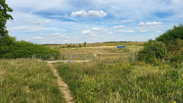
Brogborough Road Spinney is a small woodland area located in Bedfordshire, England. Situated near the village of Brogborough, the spinney is a picturesque and tranquil spot known for its natural beauty and diverse range of flora and fauna.

Covering an area of approximately 20 acres, Brogborough Road Spinney is primarily composed of deciduous trees, including oak, ash, and beech. These trees form a dense canopy overhead, providing shade and shelter for an array of wildlife. The forest floor is adorned with a variety of wildflowers, such as bluebells, primroses, and wood anemones, which bloom in vibrant colors during the springtime.

The spinney is crisscrossed by several footpaths, which allow visitors to explore the area and enjoy its natural wonders. The paths wind through the woodland, leading to small clearings and hidden ponds. These water features attract an abundance of wildlife, including various bird species, such as woodpeckers, owls, and warblers, as well as small mammals like squirrels, foxes, and rabbits.

Brogborough Road Spinney is a haven for nature enthusiasts and photographers, offering countless opportunities to capture the beauty of its surroundings. The tranquil atmosphere and diverse ecosystem make it a popular spot for birdwatching, nature walks, and simply enjoying the serenity of the natural world.

Managed by local authorities, the spinney is carefully maintained to preserve its unique character and ecological balance. It serves as a valuable habitat for wildlife and a cherished recreational area for the local community and visitors alike.

If you have any feedback on the listing, please let us know in the comments section below.

Brogborough Road Spinney Images

Images are sourced within 2km of 52.041314/-0.59346238 or Grid Reference SP9639. Thanks to Geograph Open Source API. All images are credited.

Brogborough former land fill site The large area is returning to nature well.
Brogborough former land fill site
The large area is returning to nature well.
Ridgmont Station from the A507 bridge A view of Ridgmont Station looking east from the A507 bridge.  The grey building in the middle left is the Network Rail Marston Vale Signalling Centre from where traffic on the Bletchley to Bedford line is controlled.  The station building is now the Marston Vale Heritage Centre and Cafe.
Ridgmont Station from the A507 bridge
A view of Ridgmont Station looking east from the A507 bridge. The grey building in the middle left is the Network Rail Marston Vale Signalling Centre from where traffic on the Bletchley to Bedford line is controlled. The station building is now the Marston Vale Heritage Centre and Cafe.
Bridleway bridge at Brogborough This metal bridge carries the John Bunyan Trail across the Bedford to Bletchley railway line.  It is one of few overbridges on this line, as most of the road and footpath crossings are on the level.
Bridleway bridge at Brogborough
This metal bridge carries the John Bunyan Trail across the Bedford to Bletchley railway line. It is one of few overbridges on this line, as most of the road and footpath crossings are on the level.
Matrix board - M1 southbound
Communications Tower and Overbridge at Brogborough
Roundabout at Junction 13 of the M1
M1 Southbound near to Brogborough The M1 is a north–south motorway connecting London to Leeds, where it joins the A1(M) near Aberford. It was the first motorway to be completed in the United Kingdom.
The motorway is 193 miles long and was constructed in four phases. Most of the motorway was opened between 1959 and 1968 but the southern end was extended in 1977 and the northern end was extended in 1999.
M1 Southbound near to Brogborough
The M1 is a north–south motorway connecting London to Leeds, where it joins the A1(M) near Aberford. It was the first motorway to be completed in the United Kingdom. The motorway is 193 miles long and was constructed in four phases. Most of the motorway was opened between 1959 and 1968 but the southern end was extended in 1977 and the northern end was extended in 1999.
Warehouse at Brogborough One of many at J13 of the M1. This one is RAJA UK, a supplier of packaging materials.
Warehouse at Brogborough
One of many at J13 of the M1. This one is RAJA UK, a supplier of packaging materials.
Tourist attraction direction sign on the A421 Popular local destinations of Woburn Abbey and Safari Park, and Center [sic] Parcs.
Tourist attraction direction sign on the A421
Popular local destinations of Woburn Abbey and Safari Park, and Center [sic] Parcs.
The A421 at Brogborough Westbound, 200m to the slip road for the M1 at J13.
The A421 at Brogborough
Westbound, 200m to the slip road for the M1 at J13.
A421, exit to the southbound M1 at J13 With traffic congestion as the result of a hold-up on the motorway.
A421, exit to the southbound M1 at J13
With traffic congestion as the result of a hold-up on the motorway.
Wood End Farm Wood End Farm, Cranfield.
Wood End Farm
Wood End Farm, Cranfield.
Marston Vale The view across Marston Vale to Lidlington from Wood End Farm, Cranfield.
Marston Vale
The view across Marston Vale to Lidlington from Wood End Farm, Cranfield.
What a Load of Rubbish The land-fill site at Brogborough.
What a Load of Rubbish
The land-fill site at Brogborough.
A421 The A421 between Marston Moretaine and Brogborough.
A421
The A421 between Marston Moretaine and Brogborough.
Edge of the Brogborough Landfill Site More than 90% of the area of this gridsquare if covered by the Brogborough Landfill Site (to the right of shot) which is managed for electricity production from the waste gases passing along these pipes.
Edge of the Brogborough Landfill Site
More than 90% of the area of this gridsquare if covered by the Brogborough Landfill Site (to the right of shot) which is managed for electricity production from the waste gases passing along these pipes.
Brogborough Landfill Site This is the point at which an old bridleway runs up to the edge of the Brogborough Landfill Site, an ex-brick clay quarry operated by Shanks Group plc; a company specialising in waste manangement and electricity generation from landfill gases.
Brogborough Landfill Site
This is the point at which an old bridleway runs up to the edge of the Brogborough Landfill Site, an ex-brick clay quarry operated by Shanks Group plc; a company specialising in waste manangement and electricity generation from landfill gases.
Lidlington Reservoir and Escheat Farm Aerial view of the reservoir adjacent to the small town of Lidlington.  The buildings in the foreground are Escheats Farm and Vale Farm.  The road skirting the reservoir is the A421.   On the right of the farms is a dismantled railway line - I have not ascertained what its route was, but part of it appears to have been reused in the vicinity of Brogborough for an improved routing of the A421.
Lidlington Reservoir and Escheat Farm
Aerial view of the reservoir adjacent to the small town of Lidlington. The buildings in the foreground are Escheats Farm and Vale Farm. The road skirting the reservoir is the A421. On the right of the farms is a dismantled railway line - I have not ascertained what its route was, but part of it appears to have been reused in the vicinity of Brogborough for an improved routing of the A421.
Show me another place!

Brogborough Road Spinney is located at Grid Ref: SP9639 (Lat: 52.041314, Lng: -0.59346238)

Unitary Authority: Central Bedfordshire

Police Authority: Bedfordshire

What 3 Words

///bonkers.profile.unframed. Near Lidlington, Bedfordshire

Nearby Locations

Brogborough Road Spinney

Related Wikis

Brogborough

Brogborough is a village and civil parish in the Central Bedfordshire district of Bedfordshire, England, by junction 13 of the M1 motorway. According...

Rugemont Castle

Rugemont Castle was a castle in the village of Ridgmont, in the county of Bedfordshire, England (grid reference SP97033846). == History == Not much is...

Hulcote, Bedfordshire

Hulcote is a village and (as Holcot) a former civil parish, now in the parish of Hulcote and Salford, in the Central Bedfordshire district of the ceremonial...

Ridgmont railway station

Ridgmont railway station is a small unstaffed railway station that serves the village of Ridgmont in Bedfordshire. The station is about 1 mile (2 km) away...

Nearby Amenities

Located within 500m of 52.041314,-0.59346238
Man Made: mast
Tower Type: communication
Lat/Long: 52.0387046/-0.5947234
Place: farm
Lat/Long: 52.0445329/-0.5939888
Power: pole
Lat/Long: 52.0412996/-0.588946
Power: pole
Lat/Long: 52.0406429/-0.5880046
Power: pole
Lat/Long: 52.0399467/-0.5867949
Direction: 120
Generator Method: photovoltaic
Generator Output Electricity: yes
Generator Solar Modules: 112
Generator Source: solar
Generator Type: solar_photovoltaic_panel
Location: roof
Power: generator
Tilt: 20
Lat/Long: 52.0413802/-0.5994116
The data included in this document is from www.openstreetmap.org. The data is made available under ODbL.

Have you been to Brogborough Road Spinney?

Leave your review of Brogborough Road Spinney below (or comments, questions and feedback).